The posts in this forum are NOT official forecasts and should not be used as such. They are just the opinion of the poster and may or may not be backed by sound meteorological data. They are NOT endorsed by any professional institution or STORM2K. For official information, please refer to products from the National Hurricane Center and National Weather Service.
Almost a "bifurcated" look with the well above avg subtropics and southern half of the MDR, with the anoms in between being above avg but not to the extent of the other two areas listed. I could definitely see at least some modest stability issues arising from the subtropical warmth, but it's not like the MDR proper is cool, so perhaps not overwhelmingly so? I'm probably just spitballing here though
2 likes
Please note the thougths expressed by this account are solely those of the user and are from a hobbyist perspective. For more comprehensive analysis, consult an actual professional meteorologist or meteorology agency.
Almost a "bifurcated" look with the well above avg subtropics and southern half of the MDR, with the anoms in between being above avg but not to the extent of the other two areas listed. I could definitely see at least some modest stability issues arising from the subtropical warmth, but it's not like the MDR proper is cool, so perhaps not overwhelmingly so? I'm probably just spitballing here though
Maybe some wavebreaking issues like in 2022?
0 likes
Visit the Caribbean-Central America Weather Thread where you can find at first post web cams,radars and observations from Caribbean basin members Click Here
Almost a "bifurcated" look with the well above avg subtropics and southern half of the MDR, with the anoms in between being above avg but not to the extent of the other two areas listed. I could definitely see at least some modest stability issues arising from the subtropical warmth, but it's not like the MDR proper is cool, so perhaps not overwhelmingly so? I'm probably just spitballing here though
Please note the thougths expressed by this account are solely those of the user and are from a hobbyist perspective. For more comprehensive analysis, consult an actual professional meteorologist or meteorology agency.
DorkyMcDorkface wrote:Almost a "bifurcated" look with the well above avg subtropics and southern half of the MDR, with the anoms in between being above avg but not to the extent of the other two areas listed. I could definitely see at least some modest stability issues arising from the subtropical warmth, but it's not like the MDR proper is cool, so perhaps not overwhelmingly so? I'm probably just spitballing here though
I would say these are two separate issues. That is, SSTA gradient (thermodynamic issue) is not the primary driver for Rossby wave breaking (a dynamic/barotropic issue). However, the overall atmospheric pattern/teleconnections are often similar (e.g., enhanced subtropical high -> increased surface heating/lower-tropospheric warmth in the subtropics -> amplified subtropical jet stream). We can have a SSTA gradient issue without Rossby wave breaking (RWB), and vice versa. These are the primary two negatives I see heading into this season, and I'll break it down below.
Stability Issues from Warmer Subtropical/North Atlantic SSTAs When the subtropics/North Atlantic are warmer than the MDR, the meridional temperature gradient weakens, reducing the instability needed for deep convection in the MDR and Caribbean. This leads to:
Increased Static Stability: Warmer subtropical SSTs heat the lower troposphere, creating a stronger temperature inversion or shallower lapse rate, inhibiting vertical motion and convection.
Reduced Convection: Cooler MDR SSTs relative to the subtropics limit latent heat release, weakening the convective potential of African easterly waves (AEWs) and TC genesis.
Potential Wind Shear Increase: Altered circulation patterns may enhance vertical wind shear, further stabilizing the atmosphere by disrupting TC organization.
These are primarily thermodynamic, driven by changes in the vertical temperature profile and moisture availability. Warmer subtropical SSTs -> increased lower-tropospheric temperatures -> reduced lapse rate and stabilizing the atmosphere locally in the MDR. This directly weakens convection without necessarily involving large-scale dynamical disruptions.
Stability Issues from Rossby Wave Breaking RWB occurs when large-scale Rossby waves overturn, often due to interactions with the subtropical or midlatitude jet stream, leading to equatorward intrusions of troughs or anticyclones:
Strengthening the Subtropical High and Jet Stream: Enhanced surface heating strengthens the Azores-Bermuda High and amplifies the jet stream, promoting wave amplification and breaking.
Facilitating Trough Intrusions: Warmer SSTs can modulate upper-level circulation, encouraging Rossby waves to propagate equatorward and break, introducing high shear and dry air into the tropics.
This is a dynamic process involving the nonlinear overturning of Rossby waves in the upper troposphere/lower stratosphere. RWB introduces extratropical influences (e.g., troughs, shear, dry air) into the tropics, altering the large-scale circulation and creating unfavorable conditions for TC genesis. This can lead to increased vertical wind shear, additional subsidence dumping in the MDR, and advection of continental dry air. We typically see this occur when there is a sharp temperature gradient between the subtropics/North Atlantic and the continental air over North America. 2013 is a great example of this, because our thermohaline circulation and overall atmospheric circulation remained in a spring time pattern (meaning we had a continual parade of mid-latitude systems even into August/September that created a strong temperature gradient and introduced Rossby wave breaking).
Thanks for the explanation, if I could like this post a hundred times over I would...
3 likes
Please note the thougths expressed by this account are solely those of the user and are from a hobbyist perspective. For more comprehensive analysis, consult an actual professional meteorologist or meteorology agency.
Visit the Caribbean-Central America Weather Thread where you can find at first post web cams,radars and observations from Caribbean basin members Click Here
You know, for all the recent generic talk of a season with cool sea surface temperatures, the MDR looks to have warmed up quite significantly since spring. Also, there seem to be hints of a fairly warm Canary Current trying to take place.
I think there's a lot more uncertainty this year than last year in terms of activity expectations, but last year shouldn't be a good comparison year as the MDR was so dang warm, almost record-breaking warm at the time of year, that it makes for a very unfair/poor comparison.
Bottom line is, we're likely going to have a neutral ENSO state, with the absence of El Nino. We don't have a "cold" tropical Atlantic Ocean. I think that alone is a setup for a rather busy season.
9 likes
Unless explicitly stated, all info in my posts is based on my own opinions and observations. Tropical storms and hurricanes can be extremely dangerous. Do not think you can beat Mother Nature. Refer to an accredited weather research agency or meteorologist if you need to make serious decisions regarding an approaching storm.
You know, for all the recent generic talk of a season with cool sea surface temperatures, the MDR looks to have warmed up quite significantly since spring. Also, there seem to be hints of a fairly warm Canary Current trying to take place.
I think there's a lot more uncertainty this year than last year in terms of activity expectations, but last year shouldn't be a good comparison year as the MDR was so dang warm, almost record-breaking warm at the time of year, that it makes for a very unfair/poor comparison.
Bottom line is, we're likely going to have a neutral ENSO state, with the absence of El Nino. We don't have a "cold" tropical Atlantic Ocean. I think that alone is a setup for a rather busy season.
Without 2023 & 2024, a glance at that SSTa map would cause most everyone to expect an above average season. 2023 & 2024 were just crazy anomalous. I am curious how this year's SST pattern looks compared to 2017. Whatever the case the reality is that SSTs will be more than warm enough to support plenty of storms, the unknown is the steering currents (which are impossible to predict at this stage).
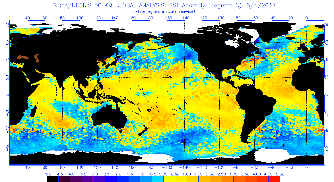
This is what 2017 looked today:
Cooler subtropics/North Atlantic and a warmer Canary Current/eastern mdr.
You know, for all the recent generic talk of a season with cool sea surface temperatures, the MDR looks to have warmed up quite significantly since spring. Also, there seem to be hints of a fairly warm Canary Current trying to take place.
I think there's a lot more uncertainty this year than last year in terms of activity expectations, but last year shouldn't be a good comparison year as the MDR was so dang warm, almost record-breaking warm at the time of year, that it makes for a very unfair/poor comparison.
Bottom line is, we're likely going to have a neutral ENSO state, with the absence of El Nino. We don't have a "cold" tropical Atlantic Ocean. I think that alone is a setup for a rather busy season.
Without 2023 & 2024, a glance at that SSTa map would cause most everyone to expect an above average season. 2023 & 2024 were just crazy anomalous. I am curious how this year's SST pattern looks compared to 2017. Whatever the case the reality is that SSTs will be more than warm enough to support plenty of storms, the unknown is the steering currents (which are impossible to predict at this stage).
1 likes
I am NOT a professional meteorologist, so take all of my posts with a grain of salt. My opinions are mine and mine alone.
Yeah looks like a CAG setup for real this time. As Andy mentioned though I would hedge on an EPAC system being more likely given climo this time of year, but as usual with these setups you cannot definitively make such a conclusion this far out in time.
3 likes
Please note the thougths expressed by this account are solely those of the user and are from a hobbyist perspective. For more comprehensive analysis, consult an actual professional meteorologist or meteorology agency.
You know, for all the recent generic talk of a season with cool sea surface temperatures, the MDR looks to have warmed up quite significantly since spring. Also, there seem to be hints of a fairly warm Canary Current trying to take place.
I think there's a lot more uncertainty this year than last year in terms of activity expectations, but last year shouldn't be a good comparison year as the MDR was so dang warm, almost record-breaking warm at the time of year, that it makes for a very unfair/poor comparison.
Bottom line is, we're likely going to have a neutral ENSO state, with the absence of El Nino. We don't have a "cold" tropical Atlantic Ocean. I think that alone is a setup for a rather busy season.
Without 2023 & 2024, a glance at that SSTa map would cause most everyone to expect an above average season. 2023 & 2024 were just crazy anomalous. I am curious how this year's SST pattern looks compared to 2017. Whatever the case the reality is that SSTs will be more than warm enough to support plenty of storms, the unknown is the steering currents (which are impossible to predict at this stage).
The ECMWF may update is up. It has ACE between 130-140. Precipitation not too high at MDR between Africa and Lesser Antilles but goes up in Caribbean. (Homegrowns?)
Visit the Caribbean-Central America Weather Thread where you can find at first post web cams,radars and observations from Caribbean basin members Click Here
cycloneye wrote:The ECMWF may update is up. It has ACE between 130-140. Precipitation not too high at MDR between Africa and Lesser Antilles but goes up in Caribbean. (Homegrowns?)
Thanks, Luis. 1. The May 2025 Euro Atlantic basin forecast numbers for 2025 are pretty similar to the April 2025 Euro forecasts for 2025. They’re actually slightly less active with ACE of 110% vs 120%.
2. The May 2025 Euro forecasts for 2025 are way less active than those of the May 2024 forecasts for 2024 but they’re not calling for a quiet season as they’re calling for near normal:
-ACE: 110% vs 200% -# of H: 7.1 vs 12.8 -# of NS: 14.5 vs 22.8 -Activity from Gulf through NW Caribbean, Florida, and Bahamas is similar to last month’s forecast, which is notably lower than 2024 with it enhanced in May of 2024 (almost all red on the map those areas) vs mainly near normal in May of 2025 (actually has slightly reduced vs normal (blue) in small areas)
In summary, the latest Euro (May) is similar to the April forecast for the 2025 season with near normal (not quiet) vs well above normal in their 2024 forecasts.
3 likes
Personal Forecast Disclaimer: The posts in this forum are NOT official forecasts and should not be used as such. They are just the opinion of the poster and may or may not be backed by sound meteorological data. They are NOT endorsed by any professional institution or storm2k.org. For official information, please refer to the NHC and NWS products.
cycloneye wrote:The ECMWF may update is up. It has ACE between 130-140. Precipitation not too high at MDR between Africa and Lesser Antilles but goes up in Caribbean. (Homegrowns?)
2016, 2018/2019, 2021, and 2023 have shown that 130-140 or more ace can be achieved with only an average quantity of hurricanes. I think 2019/2021 had a similar sst configuration with a warm band in the subtropics, an avg mdr, and above normal ssts along the equator.
EC May seasonal outlook just arrived. EC is forecasting a rather normal number of storms - 14.5 named storms - normal is 14.6. Only 7.2 hurricanes - normal is 7.5. ACE only 10% above normal. Dry in the deep tropics east of the Caribbean. I'm hoping it's even quiet than that. Perhaps we'll have more storms recurving east of the Caribbean. I say watch out NE Caribbean and East U.S. Coast this year. Quieter Gulf.
wxman57 wrote:EC May seasonal outlook just arrived. EC is forecasting a rather normal number of storms - 14.5 named storms - normal is 14.6. Only 7.2 hurricanes - normal is 7.5. ACE only 10% above normal. Dry in the deep tropics east of the Caribbean. I'm hoping it's even quiet than that. Perhaps we'll have more storms recurving east of the Caribbean. I say watch out NE Caribbean and East U.S. Coast this year. Quieter Gulf.
Ummm, don't like the words watch out NE Caribbean.
2 likes
Visit the Caribbean-Central America Weather Thread where you can find at first post web cams,radars and observations from Caribbean basin members Click Here
wxman57 wrote:EC May seasonal outlook just arrived. EC is forecasting a rather normal number of storms - 14.5 named storms - normal is 14.6. Only 7.2 hurricanes - normal is 7.5. ACE only 10% above normal. Dry in the deep tropics east of the Caribbean. I'm hoping it's even quiet than that. Perhaps we'll have more storms recurving east of the Caribbean. I say watch out NE Caribbean and East U.S. Coast this year. Quieter Gulf.
Yeah that's fair. If I'm not mistaken neutral years typically feature more East Coast strikes than Gulf ones? Although there's more to it than just ENSO obviously. Worth mentioning three of the CSU's analogs had significant landfalls on the eastern seaboard (1996, 1999, 2011).
3 likes
Please note the thougths expressed by this account are solely those of the user and are from a hobbyist perspective. For more comprehensive analysis, consult an actual professional meteorologist or meteorology agency.
Visit the Caribbean-Central America Weather Thread where you can find at first post web cams,radars and observations from Caribbean basin members Click Here