Texas Spring 2025
Moderator: S2k Moderators
Forum rules

The posts in this forum are NOT official forecast and should not be used as such. They are just the opinion of the poster and may or may not be backed by sound meteorological data. They are NOT endorsed by any professional institution or STORM2K.
-
mmmmsnouts
- Tropical Storm

- Posts: 217
- Joined: Tue Sep 05, 2023 10:04 pm
- Location: Arlington, TX
Re: Texas Spring 2025
Warning no longer says a confirmed tornado. If you draw a line down the middle of the warning box it goes through Cresson, Burleson, and Mansfield.
0 likes
-
txtwister78

- Category 5

- Posts: 2204
- Joined: Wed Jan 30, 2019 12:56 pm
- Location: San Antonio
Re: Texas Spring 2025
cheezyWXguy wrote:txtwister78 wrote:Tornadic circulation has occluded. Have to watch to see if this cycles but it has definitely weakened which is good sign for the time being.
Looks like it’s trying. This storm has held together better than I would have expected. Not sure if loss of daytime heating will kill this off in time for southern dfw to avoid being affected
Yeah hail core increasing again and it's trying to reform another circulation a little south of the old location so definitely cycling.
0 likes
-
rwfromkansas
- Category 5
- Posts: 3038
- Joined: Sat Aug 27, 2005 12:47 am
- Location: North Fort Worth
Re: Texas Spring 2025
Starting to get light rain in north FW/ Saginaw area from the storm. Heavy rain and hail looks to stay along and south of I-30.
0 likes
-
txtwister78
- Category 5
- Posts: 2204
- Joined: Wed Jan 30, 2019 12:56 pm
- Location: San Antonio
-
HockeyTx82
- S2K Supporter

- Posts: 2796
- Joined: Tue Oct 27, 2009 11:17 am
- Location: Ponder, TX
Re: Texas Spring 2025
The storm in Denton County, Ponder, has been a constant 20 to 35 mph wind. I picked over an inch of rain.
It's really falling apart as it gets towards downtown Fort Worth, the storm to the South that is.
It's really falling apart as it gets towards downtown Fort Worth, the storm to the South that is.
0 likes
Don't hold me accountable for anything I post on this forum. Leave the real forecasting up to the professionals.
Location: Ponder, TX (all observation posts are this location unless otherwise noted)
Location: Ponder, TX (all observation posts are this location unless otherwise noted)
-
ElectricStorm

- Category 5
- Posts: 5147
- Age: 25
- Joined: Tue Aug 13, 2019 11:23 pm
- Location: Norman, OK
Re: Texas Spring 2025
New cell in Kansas rapidly blew up and now has a strong meso, significant tornado likey soon just south of... Greensburg 
0 likes
B.S Meteorology, University of Oklahoma '25
Please refer to the NHC, NWS, or SPC for official information.
Please refer to the NHC, NWS, or SPC for official information.
-
HockeyTx82
- S2K Supporter
- Posts: 2796
- Joined: Tue Oct 27, 2009 11:17 am
- Location: Ponder, TX
Re: Texas Spring 2025
Brent wrote:Radar indicated tornado just east of Denton
That's the storm that was rocking me in Ponder. You line that up it, it was basically be right over my house if that started west of 35.
I'm listening on the radio power flashes being reported. Chasers chasing the storm
0 likes
Don't hold me accountable for anything I post on this forum. Leave the real forecasting up to the professionals.
Location: Ponder, TX (all observation posts are this location unless otherwise noted)
Location: Ponder, TX (all observation posts are this location unless otherwise noted)
-
HockeyTx82
- S2K Supporter
- Posts: 2796
- Joined: Tue Oct 27, 2009 11:17 am
- Location: Ponder, TX
Re: Texas Spring 2025
It's almost like that collapsing storm allowed the one up north to go stronger
2 likes
Don't hold me accountable for anything I post on this forum. Leave the real forecasting up to the professionals.
Location: Ponder, TX (all observation posts are this location unless otherwise noted)
Location: Ponder, TX (all observation posts are this location unless otherwise noted)


-
HockeyTx82
- S2K Supporter
- Posts: 2796
- Joined: Tue Oct 27, 2009 11:17 am
- Location: Ponder, TX
Re: Texas Spring 2025
Day two has concluded, so what are your predictions for day three? Will the excitement continue in North Texas, or will Oklahoma and Nebraska dominate the event?
0 likes
Don't hold me accountable for anything I post on this forum. Leave the real forecasting up to the professionals.
Location: Ponder, TX (all observation posts are this location unless otherwise noted)
Location: Ponder, TX (all observation posts are this location unless otherwise noted)
-
rwfromkansas
- Category 5
- Posts: 3038
- Joined: Sat Aug 27, 2005 12:47 am
- Location: North Fort Worth
Re: Texas Spring 2025
Mile wide tornado a county SW of my hometown up in KS. No major towns for a bit, but a city of 40,000 in the path.
0 likes
-
ElectricStorm
- Category 5
- Posts: 5147
- Age: 25
- Joined: Tue Aug 13, 2019 11:23 pm
- Location: Norman, OK
Re: Texas Spring 2025
Tornado Emergency Plevna, KS. That's one of the largest debris balls I've ever seen
0 likes
B.S Meteorology, University of Oklahoma '25
Please refer to the NHC, NWS, or SPC for official information.
Please refer to the NHC, NWS, or SPC for official information.
-
mmmmsnouts
- Tropical Storm
- Posts: 217
- Joined: Tue Sep 05, 2023 10:04 pm
- Location: Arlington, TX
Re: Texas Spring 2025
I can’t remember the cap knocking down a cell as big as that one in Erath/Hood to absolutely nothing so quickly. I’m not even sure it rained at all in Arlington. (Though we did have several passing showers early afternoon.)
0 likes
-
ElectricStorm
- Category 5
- Posts: 5147
- Age: 25
- Joined: Tue Aug 13, 2019 11:23 pm
- Location: Norman, OK
Re: Texas Spring 2025
Well today ended up being quite the outbreak with several destructive wedges in KS and multiple other tornadoes in Oklahoma, Texas, and Colorado. Despite the overall low storm coverage south of the OK/KS border, I think today played out pretty much as expected for the most part, although I thought we would see a couple more cells in OK than we did.
Tomorrow (Monday) has a high ceiling if storms can stay discrete/semi-discrete with multiple rounds moving through eastern OK. Central OK and north TX seem more uncertain but we'll see. However, most model runs I've seen so far keep it pretty messy, probably due to shear being less perpendicular than it was today. SPC outlook will be out soon and while I do think a 15# could be necessary later on, I would probably leave it at 10# for this update. Regardless, another dangerous day if even a couple storms can stay discrete.
Tomorrow (Monday) has a high ceiling if storms can stay discrete/semi-discrete with multiple rounds moving through eastern OK. Central OK and north TX seem more uncertain but we'll see. However, most model runs I've seen so far keep it pretty messy, probably due to shear being less perpendicular than it was today. SPC outlook will be out soon and while I do think a 15# could be necessary later on, I would probably leave it at 10# for this update. Regardless, another dangerous day if even a couple storms can stay discrete.
1 likes
B.S Meteorology, University of Oklahoma '25
Please refer to the NHC, NWS, or SPC for official information.
Please refer to the NHC, NWS, or SPC for official information.
-
Brent
- S2K Supporter
- Posts: 38755
- Age: 37
- Joined: Sun May 16, 2004 10:30 pm
- Location: Tulsa Oklahoma
- Contact:
Re: Texas Spring 2025
ElectricStorm wrote:Well today ended up being quite the outbreak with several destructive wedges in KS and multiple other tornadoes in Oklahoma, Texas, and Colorado. Despite the overall low storm coverage south of the OK/KS border, I think today played out pretty much as expected for the most part, although I thought we would see a couple more cells in OK than we did.
Tomorrow (Monday) has a high ceiling if storms can stay discrete/semi-discrete with multiple rounds moving through eastern OK. Central OK and north TX seem more uncertain but we'll see. However, most model runs I've seen so far keep it pretty messy, probably due to shear being less perpendicular than it was today. SPC outlook will be out soon and while I do think a 15# could be necessary later on, I would probably leave it at 10# for this update. Regardless, another dangerous day if even a couple storms can stay discrete.
They went moderate already wow


0 likes
#neversummer
-
HockeyTx82
- S2K Supporter
- Posts: 2796
- Joined: Tue Oct 27, 2009 11:17 am
- Location: Ponder, TX
Re: Texas Spring 2025
So what's the thoughts for today? Sounds like we have a cap in place over DFW, but Oklahoma is ground zero.
Obviously rain is needed but hopefully the severe threat stays in check.
Obviously rain is needed but hopefully the severe threat stays in check.
0 likes
Don't hold me accountable for anything I post on this forum. Leave the real forecasting up to the professionals.
Location: Ponder, TX (all observation posts are this location unless otherwise noted)
Location: Ponder, TX (all observation posts are this location unless otherwise noted)
-
Brent
- S2K Supporter
- Posts: 38755
- Age: 37
- Joined: Sun May 16, 2004 10:30 pm
- Location: Tulsa Oklahoma
- Contact:
Re: Texas Spring 2025
HockeyTx82 wrote:So what's the thoughts for today? Sounds like we have a cap in place over DFW, but Oklahoma is ground zero.
Obviously rain is needed but hopefully the severe threat stays in check.
Yeah it looks bad up here
Best hope if it gets messy and we shift towards a flooding threat
Looks like more severe weather possible next weekend
0 likes
#neversummer
-
wxman22

- Category 5
- Posts: 1951
- Joined: Mon Jan 30, 2006 12:39 am
- Location: Wichita Falls, TX
- Contact:
Re: Texas Spring 2025
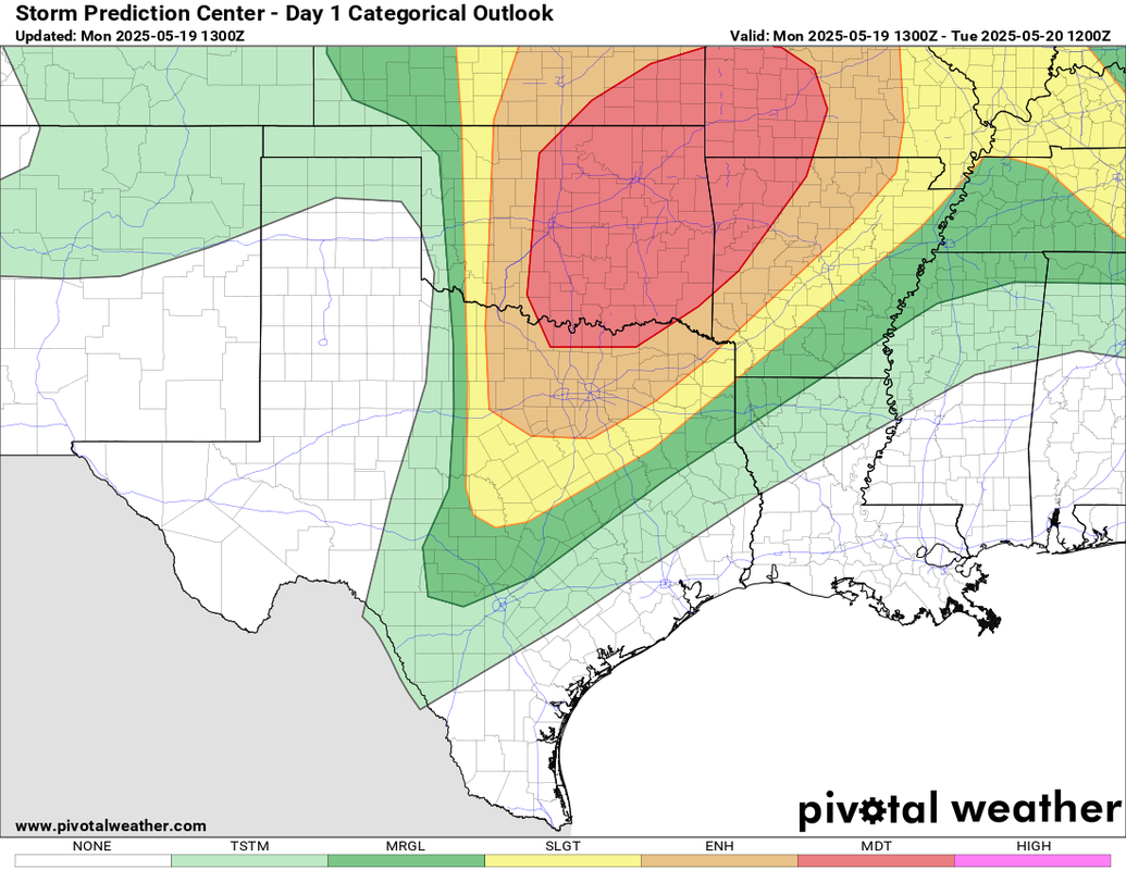
Day 1 Convective Outlook
NWS Storm Prediction Center Norman OK
0751 AM CDT Mon May 19 2025
Valid 191300Z - 201200Z
...THERE IS A MODERATE RISK OF SEVERE THUNDERSTORMS FAR NORTH
TEXAS...MUCH OF CENTRAL AND EASTERN OKLAHOMA...SOUTHEAST
KANSAS...AND THE OZARKS...
...SUMMARY...
Significant severe weather is likely from the central/southern
Plains into the the Ozarks today into tonight. All severe weather
hazards are expected, to include tornadoes (some potentially strong
to intense), very large hail, and severe winds.
... Synopsis ...
A large, amplified trough over the Rockies will shift slowly
eastward into the Plains today. Embedded within this longwave
trough, a complex evolution is expected. Downstream of the trough, a
negatively tilted shortwave trough will deepen and close off across
the northern Plains. Meanwhile, upstream, a closed low currently
over Idaho will dig southeastward, open up, and eject into the
central Plains.
As this evolution occurs, strong midlevel flow (in excess of 50
knots) will remain across much of the central and southern Plains
through the forecast period. By late in the afternoon, midlevel flow
will strengthen to perhaps 70 knots in response to the ejecting low
into the central Plains.
At the surface, the main synoptic low will be somewhat
diffuse/elongated over northwest Kansas into southwest Nebraska this
morning. Extending southward from this low, a dryline will stretch
through western Kansas into the Oklahoma and Texas Panhandles,
continuing into west Texas. A warm front will extend eastward near
the Kansas-Nebraska border before curving southeastward into
Missouri into the southern Appalachians.
The surface low is expected to gradually fill today as it slowly
moves east/northeast into south-central Nebraska, Despite this, rich
Gulf moisture will be maintained across the central and southern
Plains. Dewpoint temperatures at or above 70F will advect northward
from Texas through Oklahoma perhaps to as far north as northeast
Kansas.
During the afternoon, strong diurnal heating along the dryline may
result in a sub-synoptic low developing across northwest Oklahoma.
This low will slowly progress east along the Oklahoma-Kansas border
during the afternoon, weakening with time.
... Southern and Central Plains into the Ozarks ...
A strongly sheared atmosphere will already be in place at the start
of the forecast period. As diurnal heating commences and 70F
dewpoints advect northward, the atmosphere across much of the
central and southern Plains will become strongly to extremely
unstable as well, with surface-based CAPE values between 3000-5000
J/kg across the region.
Multiple rounds of storms are expected across the region today. One
such initiating mechanism looks to be a subtle shortwave trough
embedded in the larger scale flow currently across eastern New
Mexico. This wave should initiate thunderstorms across eastern
Oklahoma northward into eastern Kansas by midday. It is unclear if
these storms will initially be elevated, but as they move east and
the atmosphere destabilizes further ahead of the line, a transition
to more surface-based convection should occur. At the same time, the
low-level jet is forecast to strengthen/reorganize across eastern
Oklahoma/western Arkansas into western Missouri. This will yield
ample low-level curvature to the hodograph. Thus, given the strongly
sheared environment in place, supercells capable of producing all
severe hazards, including strong tornadoes, will be possible with
this first round of storms.
By mid-to-late afternoon, 30-60 meter mid-level height falls should
overspread the dryline as it mixes east into central Kansas
southward into western north Texas. Rapid thunderstorm development
is expected along the dryline given the forecast extreme
instability. These thunderstorms should develop west of the better
low-level jet/flow, where the low-level flow is expected to be a
little more veered than across eastern Kansas/Oklahoma. This veered
low-level flow still will result in a strongly sheered environment,
but with more straight hodographs and less low-level curvature. The
result should be another round of supercells, albeit with a tendency
to split. These supercells will be capable of producing very large
hail and tornadoes. The number of supercells across the dryline
combined with a propensity to split, may result in destructive
interference and result in a more episodic hail and tornado threat.
In addition to the hail and tornado threat, the number of expected
thunderstorms in the presence of a very moist and unstable
atmosphere with steep lapse rates may result in strong downdraft
winds. The most likely region for this will be across portions of
northeast Oklahoma, northwest Arkansas, southeast Kansas, and
southwest Missouri. A 45% wind area was included in this outlook.
0 likes
-
cheezyWXguy

- Category 5
- Posts: 6282
- Joined: Mon Feb 13, 2006 12:29 am
- Location: Dallas, TX