I just checked the Home Weather Station, it was in the 90s and now it's down to 75 after that outflow boundary crossed through out in Ponder.
I wonder what impact that'll have on the north side of it for any future development later on.
Texas Spring 2025
Moderator: S2k Moderators
Forum rules

The posts in this forum are NOT official forecast and should not be used as such. They are just the opinion of the poster and may or may not be backed by sound meteorological data. They are NOT endorsed by any professional institution or STORM2K.
-
HockeyTx82
- S2K Supporter

- Posts: 2795
- Joined: Tue Oct 27, 2009 11:17 am
- Location: Ponder, TX
Re: Texas Spring 2025
0 likes
Don't hold me accountable for anything I post on this forum. Leave the real forecasting up to the professionals.
Location: Ponder, TX (all observation posts are this location unless otherwise noted)
Location: Ponder, TX (all observation posts are this location unless otherwise noted)
-
wxman22

- Category 5

- Posts: 1948
- Joined: Mon Jan 30, 2006 12:39 am
- Location: Wichita Falls, TX
- Contact:
Re: Texas Spring 2025

Mesoscale Discussion 0931
NWS Storm Prediction Center Norman OK
0144 PM CDT Thu May 22 2025
Areas affected...parts of western North Texas and adjacent
southwestern Oklahoma
Concerning...Severe potential...Watch possible
Valid 221844Z - 222045Z
Probability of Watch Issuance...60 percent
SUMMARY...Isolated supercell development may initiate west through
southwest of the Wichita Falls area during the next hour or two.
Trends are being monitored for the possibility of a new severe
weather watch.
DISCUSSION...Deepening convective development is ongoing to the
west-southwest of Wichita Falls TX, where a corridor of stronger
heating/deeper boundary-layer mixing has contributed to weakening
inhibition for boundary-layer parcels characterized by CAPE up to
3000 J/kg. At the same time, southwestward propagating gravity
waves and outflow, generated by the more intense earlier convection
southwest of Ardmore OK, are approaching from the northwest and
could support at least isolated intensifying thunderstorm
development during the next hour or two. In the presence of
moderate to strong west-northwesterly deep layer shear, this may
include an evolving supercell posing a risk for large hail and
strong damaging wind gusts.
..Kerr/Guyer.. 05/22/2025
0 likes
-
rwfromkansas
- Category 5
- Posts: 3038
- Joined: Sat Aug 27, 2005 12:47 am
- Location: North Fort Worth
Re: Texas Spring 2025
Will outflow lower the risk or increase it?
It does both sometimes.
I would think maybe provide a focus because it’s not a huge MCS but probably depends on if it brings lots of cooling.
It does both sometimes.
I would think maybe provide a focus because it’s not a huge MCS but probably depends on if it brings lots of cooling.
0 likes

Re: Texas Spring 2025
That supercell has all but dissipated. I'd lean towards a lower threat where that outflow passes by, but farther W/NW could get interesting.
But sometimes ya never know.
But sometimes ya never know.
0 likes
-
Stratton23
- Category 5
- Posts: 3563
- Joined: Fri Jul 21, 2023 10:59 pm
- Location: Katy, Tx
Re: Texas Spring 2025
Next 2 weeks or so look very encouraging for rain across the whole state as the pattern turns pretty active , might have to watch the system in the pacific as their are some hints that the moisture could get pulled into texas as it rides up the western coast of mexico
0 likes
-
cheezyWXguy

- Category 5
- Posts: 6282
- Joined: Mon Feb 13, 2006 12:29 am
- Location: Dallas, TX
Re: Texas Spring 2025
cstrunk wrote:That supercell has all but dissipated. I'd lean towards a lower threat where that outflow passes by, but farther W/NW could get interesting.
But sometimes ya never know.
There’s quite a bit of time for the atmosphere to recover before day’s end, and with no real concentrated forcing I would think convection later will be sporadic and somewhat random regardless. All that to say it probably doesn’t make much of a difference for or against imo. Probably why the CAMs have had so much trouble staying consistent.
0 likes
-
wxman22
- Category 5
- Posts: 1948
- Joined: Mon Jan 30, 2006 12:39 am
- Location: Wichita Falls, TX
- Contact:
Re: Texas Spring 2025
3 Supercells have developed up here.Jeez this part of the state seems to be a magnet for storms.Wichita county has already had 26 severe thunderstorm warnings this year.
Last edited by wxman22 on Thu May 22, 2025 3:29 pm, edited 1 time in total.
0 likes
Re: Texas Spring 2025
cheezyWXguy wrote:cstrunk wrote:That supercell has all but dissipated. I'd lean towards a lower threat where that outflow passes by, but farther W/NW could get interesting.
But sometimes ya never know.
There’s quite a bit of time for the atmosphere to recover before day’s end, and with no real concentrated forcing I would think convection later will be sporadic and somewhat random regardless. All that to say it probably doesn’t make much of a difference for or against imo. Probably why the CAMs have had so much trouble staying consistent.
A stalling outflow boundary aligned with the new WFS supercells riding southeastward could spell trouble too. Looks like the boundary is beginning to stall.
0 likes

-
rwfromkansas
- Category 5
- Posts: 3038
- Joined: Sat Aug 27, 2005 12:47 am
- Location: North Fort Worth
Re: Texas Spring 2025
Well that is weird. The boundary was plowing through, then stalled, now it's actually going back north! What the heck. How does that happen?
It literally stopped 3 miles north of me. I'm at 92 degrees.
It literally stopped 3 miles north of me. I'm at 92 degrees.
0 likes
-
wxman22
- Category 5
- Posts: 1948
- Joined: Mon Jan 30, 2006 12:39 am
- Location: Wichita Falls, TX
- Contact:
Re: Texas Spring 2025
Getting some heavy rain with a brief period of pea size hail. More storms back building to the west.

0 likes
-
rwfromkansas
- Category 5
- Posts: 3038
- Joined: Sat Aug 27, 2005 12:47 am
- Location: North Fort Worth
Re: Texas Spring 2025
A few degrees cooler with extensive anvil clouds. But, I think the outflow washed out. No wind shift yet.
0 likes
-
wxman22
- Category 5
- Posts: 1948
- Joined: Mon Jan 30, 2006 12:39 am
- Location: Wichita Falls, TX
- Contact:
Re: Texas Spring 2025
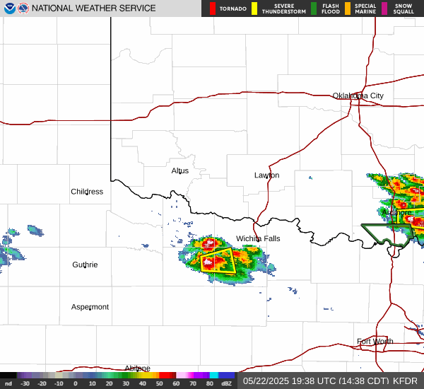
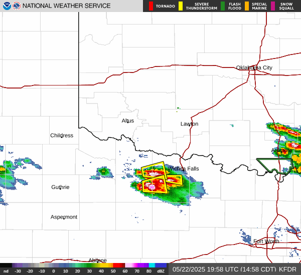
Another supercell has developed over WF. There appears to be a stalled boundary that the storms are developing off of. A Flash Flood Warning has also been issued now. These storms should eventually congeal into a MCS and move south. Numerous supercells have developed this afternoon. Thank goodness they are mostly weak. And are none tornadic.

0 likes
-
wxman22
- Category 5
- Posts: 1948
- Joined: Mon Jan 30, 2006 12:39 am
- Location: Wichita Falls, TX
- Contact:
Re: Texas Spring 2025
Supercells developing in the Hill Country.

Last edited by wxman22 on Thu May 22, 2025 6:27 pm, edited 2 times in total.
0 likes

Re: Texas Spring 2025
wxman22 wrote:Another supercell has developed over WF. There appears to be a stalled boundary that the storms are developing off of. A Flash Flood Warning has also been issued now. These storms should eventually congeal into a MCS and move south. Numerous supercells have developed this afternoon. Thank goodness they are mostly weak. And are none tornadic.
https://i.ibb.co/G4n6cCnL/KFDR-0-1.gif
Four Sixes ranch getting hit.
0 likes
-
txtwister78

- Category 5
- Posts: 2203
- Joined: Wed Jan 30, 2019 12:56 pm
- Location: San Antonio
Re: Texas Spring 2025
Yeah HRRR and even SPC missed on the southern HC development. WRF and RRFS a bit more accurate.
These are drifting south so definitely putting down some good rainfall despite the hail associated with them.
These are drifting south so definitely putting down some good rainfall despite the hail associated with them.
0 likes
-
HockeyTx82
- S2K Supporter
- Posts: 2795
- Joined: Tue Oct 27, 2009 11:17 am
- Location: Ponder, TX
Re: Texas Spring 2025
One of these days the Enhanced Risk curse will get lifted. We can't keep dodging mother nature forever. 
0 likes
Don't hold me accountable for anything I post on this forum. Leave the real forecasting up to the professionals.
Location: Ponder, TX (all observation posts are this location unless otherwise noted)
Location: Ponder, TX (all observation posts are this location unless otherwise noted)
-
rwfromkansas
- Category 5
- Posts: 3038
- Joined: Sat Aug 27, 2005 12:47 am
- Location: North Fort Worth
Re: Texas Spring 2025
Well, that’s funny. Not a drop. And it’s not super cool or something. Just nothing very impressive at all even west except for the cell diving south from Graham.
0 likes
Return to “USA & Caribbean Weather”
Who is online
Users browsing this forum: AnnularCane and 108 guests