
2025 Global Model Runs Discussion (Out thru day 16)
Moderator: S2k Moderators
Forum rules

The posts in this forum are NOT official forecasts and should not be used as such. They are just the opinion of the poster and may or may not be backed by sound meteorological data. They are NOT endorsed by any professional institution or STORM2K. For official information, please refer to products from the National Hurricane Center and National Weather Service.
Re: 2025 Global Model Runs Discussion (Out thru day 16)
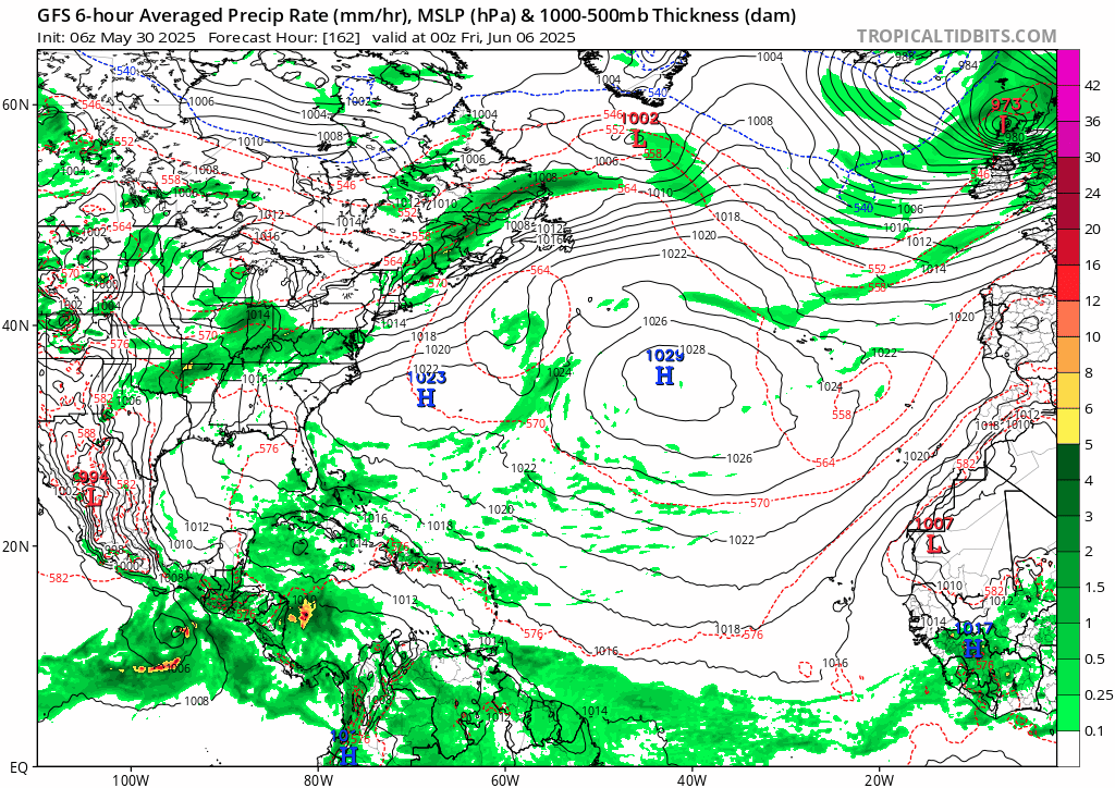
6z GFS ensembles sill on with this. 6z Operational is, well... something else. Euro ensembles have it also, but not quite as gung ho.
Last edited by BobHarlem on Fri May 30, 2025 9:53 am, edited 1 time in total.
0 likes

Re: 2025 Global Model Runs Discussion (Out thru day 16)
I'll be looking at the 00Z 5/31 GFS run to see if there is a legit TC formation forecast (144 hrs out) in the W Carib that may possibly enter the GOM.
0 likes
-
cycloneye

- Admin

- Posts: 149260
- Age: 69
- Joined: Thu Oct 10, 2002 10:54 am
- Location: San Juan, Puerto Rico
Re: 2025 Global Model Runs Discussion (Out thru day 16)
3 likes
Visit the Caribbean-Central America Weather Thread where you can find at first post web cams,radars
and observations from Caribbean basin members Click Here
and observations from Caribbean basin members Click Here

Re: 2025 Global Model Runs Discussion (Out thru day 16)
A slightly weaker on Katrina on June 10, yeah, sounds totally legit 
0 likes
TC naming lists: retirements and intensity
Most aggressive Advisory #1's in North Atlantic (cr. kevin for starting the list)
Most aggressive Advisory #1's in North Atlantic (cr. kevin for starting the list)
-
DunedinDave
- Category 1

- Posts: 269
- Joined: Fri Aug 25, 2023 10:31 am
Re: 2025 Global Model Runs Discussion (Out thru day 16)
June 10 is still a ways away. Euro is not on board with GFS idea yet so I would be skeptical right now. GFS is notorious for building something up and then nothing comes of it.
0 likes

Re: 2025 Global Model Runs Discussion (Out thru day 16)
Should get a new BOMM later today or tomorrow. All models aren't on board yet, but here we go...
1 likes


Re: 2025 Global Model Runs Discussion (Out thru day 16)
With all the GFS bashing going on across social media how many times last year was it the GFS spotting development that verified before the Euro even caught up?
Maybe a tale of two extremes. Not saying the GFS is correct in this instance, but past history is very telling.
Maybe a tale of two extremes. Not saying the GFS is correct in this instance, but past history is very telling.
1 likes
-
cycloneye
- Admin
- Posts: 149260
- Age: 69
- Joined: Thu Oct 10, 2002 10:54 am
- Location: San Juan, Puerto Rico
Re: 2025 Global Model Runs Discussion (Out thru day 16)
Umm, Andy between the lines of the message has this developing but not as the wild GFS has.
https://x.com/AndyHazelton/status/1928468513393463602
https://x.com/AndyHazelton/status/1928468513393463602
3 likes
Visit the Caribbean-Central America Weather Thread where you can find at first post web cams,radars
and observations from Caribbean basin members Click Here
and observations from Caribbean basin members Click Here
-
tolakram
- Admin
- Posts: 20178
- Age: 62
- Joined: Sun Aug 27, 2006 8:23 pm
- Location: Florence, KY (name is Mark)
Re: 2025 Global Model Runs Discussion (Out thru day 16)
MetroMike wrote:With all the GFS bashing going on across social media how many times last year was it the GFS spotting development that verified before the Euro even caught up?
Maybe a tale of two extremes. Not saying the GFS is correct in this instance, but past history is very telling.
GFS develops everything and rarely misses anything, but is wrong most of the time. Yea, when something does end up developing it's usually first.
7 likes
M a r k
- - - - -
Join us in chat: Storm2K Chatroom Invite. Android and IOS apps also available.
The posts in this forum are NOT official forecasts and should not be used as such. Posts are NOT endorsed by any professional institution or STORM2K.org. For official information and forecasts, please refer to NHC and NWS products.

Re: 2025 Global Model Runs Discussion (Out thru day 16)
MetroMike wrote:With all the GFS bashing going on across social media how many times last year was it the GFS spotting development that verified before the Euro even caught up?
Maybe a tale of two extremes. Not saying the GFS is correct in this instance, but past history is very telling.
That's a very good point. Do I think a 946mb hurricane is going to barrel into Louisiana within 2 weeks? Hell no. On the other hand, how reasonable is it for a superior global model to have a capacity to sniff out tropical genesis (to some extent) well ahead of all other global models? Sure, there is an "X" percentage that nothing at all develops in the Western Caribbean or GOM by June 15 however I think that persistent GFS model runs are highly foretelling that "something" will minimally pose a threat of developing. A tropical wave or gyre could bubble up from Central America and ultimately remain entangled with land, or something begins to organize but runs out of time, or a sloppy tropical (or subtropical) depression could form and intensify just enough to get tagged with a name and dump copious rain over Louisiana (or S Florida, Yucatan, etc).
If any of the above plays out so too will the familiar global model adjustments occur. The EURO or ICON will suddenly come to play, CMC will more or less mimic whatever the EURO suggests, and the GFS will begin backing off "Armageddon", with subsequent forecasts suggesting a much less strong and more reasonable outcome. I'd hedge toward expecting a confluence of convection and lower surface pressures that will result in our first significant Atlantic tropical disturbance. I think a reasonable outcome would range somewhere between too weak/unorganized to classify as a TD, and something near a borderline TD/TS (or "Potential advisory event).
1 likes
Andy D
(For official information, please refer to the NHC and NWS products.)
(For official information, please refer to the NHC and NWS products.)
Re: 2025 Global Model Runs Discussion (Out thru day 16)
12z gfs shifted east again, too far out to say anything more than watch this general area in a week. (Ensemble spread area) First shows up on the GFS really on the 7th/8th.

1 likes
Re: 2025 Global Model Runs Discussion (Out thru day 16)
tolakram wrote:MetroMike wrote:With all the GFS bashing going on across social media how many times last year was it the GFS spotting development that verified before the Euro even caught up?
Maybe a tale of two extremes. Not saying the GFS is correct in this instance, but past history is very telling.
GFS develops everything and rarely misses anything, but is wrong most of the time. Yea, when something does end up developing it's usually first.
True, however this perspective could just as easily be considered - The EURO, CMC, & ICON all suggest a less than 10% chance of tropical development within their window of vision. How useful is that for cruisers, vacationers, wedding planners, etc if commonly wrong ...even if the ultimate outcome is not a direct threat from a tropical storm but instead resulting in a good deal of really cruddy weather?
0 likes
Andy D
(For official information, please refer to the NHC and NWS products.)
(For official information, please refer to the NHC and NWS products.)
-
wxman57

- Moderator-Pro Met

- Posts: 23171
- Age: 68
- Joined: Sat Jun 21, 2003 8:06 pm
- Location: Houston, TX (southwest)
Re: 2025 Global Model Runs Discussion (Out thru day 16)
GFS always pulls something like this in May or June. I can't find any hint of a feature in the Euro (surface & aloft). The one positive for development is that I'll be on vacation June 8-11. Storms like to form when I'm unavailable. One thing to watch for is any evidence of development showing up in other models over the coming week.
GFS Trend Valid 18Z Tuesday, June 10th. Try copying/pasting the link below into your browser to see the animation. It won't convert to a URL here because of that "blob:" at the beginning:
blob:https://www.tropicaltidbits.com/b0257e0e-e5cb-4aa4-ba2a-5edd3660eb2e
GFS Trend Valid 18Z Tuesday, June 10th. Try copying/pasting the link below into your browser to see the animation. It won't convert to a URL here because of that "blob:" at the beginning:
blob:https://www.tropicaltidbits.com/b0257e0e-e5cb-4aa4-ba2a-5edd3660eb2e
1 likes
-
Stratton23
- Category 5

- Posts: 3517
- Joined: Fri Jul 21, 2023 10:59 pm
- Location: Katy, Tx
Re: 2025 Global Model Runs Discussion (Out thru day 16)
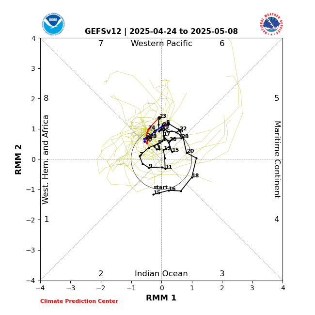
the one thing i will say that the GFS does have going for it is the MJO, favorable passage moves into the caribbean / gulf in 10-14 days, that could help to really enhance or kick start a CAG, thats something the models definitely do not handle well at all
0 likes
-
cycloneye
- Admin
- Posts: 149260
- Age: 69
- Joined: Thu Oct 10, 2002 10:54 am
- Location: San Juan, Puerto Rico
Re: 2025 Global Model Runs Discussion (Out thru day 16)
Good post from Levi Cowan. For those who may not see it, here it is.
@TropicalTidbits
The GFS model is predicting sudden hurricane development in the western Caribbean in 8-10 days.
I'll take the under. As my long-time followers know, this model is infamous for over-amplifying tropical thunderstorm complexes. You can see the massive amount of 24-hour rainfall dropped in one spot, evidence of that convection. The associated vertical mass flux generates cyclonic vorticity that quickly causes a compact, strong circulation to emerge in a high shear (unfavorable) environment. This look is typically implausible.
The quoted tweet from 3 days ago lays out why there may be opportunities for tropical storm formation as we head into the 2nd and 3rd week of June. But you can usually safely bet that the GFS will be too eager and early, especially when it's a 10-day forecast.
Don't get wrapped up in sensational posts with scary graphics depicting hurricanes in the Gulf that some social media accounts make a living on. We'll certainly be keeping tabs on this region in June, though, and if a credible threat becomes likely, you'll hear about it here and at
@NHC_Atlantic
.
https://x.com/TropicalTidbits/status/1928516790830903440
5 likes
Visit the Caribbean-Central America Weather Thread where you can find at first post web cams,radars
and observations from Caribbean basin members Click Here
and observations from Caribbean basin members Click Here

Re: 2025 Global Model Runs Discussion (Out thru day 16)
Not even June 1st and GFS is already living up.to its acronym Give Florida a Storm.
Tuesday the 10th I have a summer party on a boat in Key West, this is the only thing that favors potential development in my amatuer opinion.
Tuesday the 10th I have a summer party on a boat in Key West, this is the only thing that favors potential development in my amatuer opinion.
3 likes
-
Kingarabian

- S2K Supporter

- Posts: 16345
- Joined: Sat Aug 08, 2009 3:06 am
- Location: Honolulu, Hawaii
Re: 2025 Global Model Runs Discussion (Out thru day 16)
Also watch and see if the CMC catches on.
0 likes
RIP Kobe Bryant
-
Blown Away

- S2K Supporter
- Posts: 10253
- Joined: Wed May 26, 2004 6:17 am
Re: 2025 Global Model Runs Discussion (Out thru day 16)
In past decades it was common for a June gyre from the SW Caribbean to move up the W Coast of FL, the difference was these lows were sloppy TD’s or low end TS. June SST’s are now running above historical averages in the GOA and can support strong TS to Hurricane systems. It would not shock me to see a strong TS to Cat 1-2 in June in the E GOA (GOM).
3 likes
Hurricane Eye Experience: David 79, Irene 99, Frances 04, Jeanne 04, Wilma 05… Hurricane Brush Experience: Andrew 92, Erin 95, Floyd 99, Matthew 16, Irma 17, Ian 22, Nicole 22…
-
HurricaneBelle

- S2K Supporter
- Posts: 1209
- Joined: Sun Aug 27, 2006 6:12 pm
- Location: Clearwater, FL
Re: 2025 Global Model Runs Discussion (Out thru day 16)
Blown Away wrote:In past decades it was common for a June gyre from the SW Caribbean to move up the W Coast of FL, the difference was these lows were sloppy TD’s or low end TS. June SST’s are now running above historical averages in the GOA and can support strong TS to Hurricane systems. It would not shock me to see a strong TS to Cat 1-2 in June in the E GOA (GOM).
Just what we need, our fourth Perrycane in three seasons.
1 likes
-
tolakram
- Admin
- Posts: 20178
- Age: 62
- Joined: Sun Aug 27, 2006 8:23 pm
- Location: Florence, KY (name is Mark)
Re: 2025 Global Model Runs Discussion (Out thru day 16)
chaser1 wrote:tolakram wrote:MetroMike wrote:With all the GFS bashing going on across social media how many times last year was it the GFS spotting development that verified before the Euro even caught up?
Maybe a tale of two extremes. Not saying the GFS is correct in this instance, but past history is very telling.
GFS develops everything and rarely misses anything, but is wrong most of the time. Yea, when something does end up developing it's usually first.
True, however this perspective could just as easily be considered - The EURO, CMC, & ICON all suggest a less than 10% chance of tropical development within their window of vision. How useful is that for cruisers, vacationers, wedding planners, etc if commonly wrong ...even if the ultimate outcome is not a direct threat from a tropical storm but instead resulting in a good deal of really cruddy weather?
Keep your eye on the weather, will it actually be cruddy?
1 likes
M a r k
- - - - -
Join us in chat: Storm2K Chatroom Invite. Android and IOS apps also available.
The posts in this forum are NOT official forecasts and should not be used as such. Posts are NOT endorsed by any professional institution or STORM2K.org. For official information and forecasts, please refer to NHC and NWS products.
- - - - -
Join us in chat: Storm2K Chatroom Invite. Android and IOS apps also available.
The posts in this forum are NOT official forecasts and should not be used as such. Posts are NOT endorsed by any professional institution or STORM2K.org. For official information and forecasts, please refer to NHC and NWS products.
Who is online
Users browsing this forum: No registered users and 84 guests