2025 Global Model Runs Discussion (Out thru day 16)

This is the general tropical discussion area. Anyone can take their shot at predicting a storms path.

Moderator: S2k Moderators

Forum rules

The posts in this forum are NOT official forecasts and should not be used as such. They are just the opinion of the poster and may or may not be backed by sound meteorological data. They are NOT endorsed by any professional institution or STORM2K. For official information, please refer to products from the National Hurricane Center and National Weather Service.

Help Support Storm2K
Message
Author
User avatar
Nimbus
Category 5
Category 5
Posts: 5300
Joined: Mon Jul 19, 2004 10:54 am

Re: 2025 Global Model Runs Discussion (Out thru day 16)

#121 Postby Nimbus » Sat May 31, 2025 8:59 pm

OuterBanker wrote:0Z North on Naples along the east coast.
06 SAME AS 0Z
12Z North of Naples and up the Apps.
18Z Into NOLA as a cat 3 up Ms valley.

That's just todays runs.

GFS just loves early season CAG's.


Thought it might just be hurricane season awareness or something but The GFS will either not verify and go poof or the other models will have to start showing something pretty soon as we get into the middle of this week.
1 likes   

User avatar
StPeteMike
Category 2
Category 2
Posts: 631
Joined: Thu Jun 07, 2018 11:26 pm

Re: 2025 Global Model Runs Discussion (Out thru day 16)

#122 Postby StPeteMike » Sat May 31, 2025 9:03 pm

mitchell wrote:Several of the GFS runs, including the 18z that brings a strong hurricane into the central Gulf, look odd with the genesis of the storm. The way it shifts between systems in the PAC and Caribbean in the development phase. Almost like it's not sure which basis the development takes hold.

This is pretty typical with GFS in the early season and the Central American Gyre. Not surprisingly, as the CAG normally spits out multiple weak vortices and it all depends on what one has the best environment and furthest one away from the other vortices to get going without being impacted.

We should be in the range by Monday to really determine if this is a phantom storm or if other models start jumping in on further development. Water temps are around 86 F in the area that GFS keeps placing the point of organizing, so it’s not out of the realm to think something can form…. it’s just GFS against everything at this moment.
5 likes   
The above post is not official and should not be used as such. It is the opinion of the poster and may or may not be backed by sound meteorological data. It is not endorsed by any professional institution or storm2k.org. For official information, please refer to the NHC and NWS products.

User avatar
DorkyMcDorkface
Category 3
Category 3
Posts: 887
Age: 27
Joined: Mon Sep 30, 2019 1:32 pm
Location: Mid-Atlantic

Re: 2025 Global Model Runs Discussion (Out thru day 16)

#123 Postby DorkyMcDorkface » Sat May 31, 2025 11:47 pm

Ok, retrying this post with a different image hosting site...

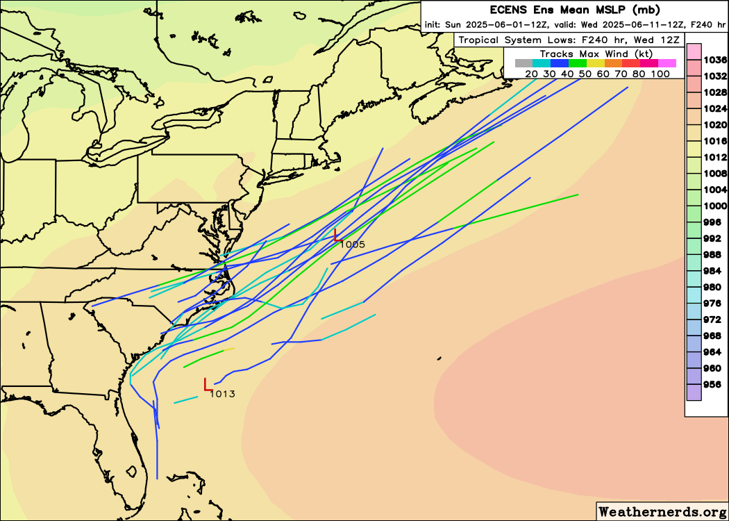
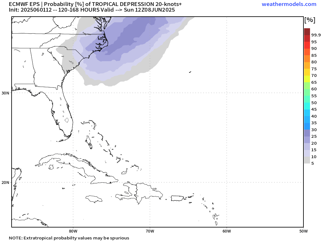
Regardless of whether or not the GFS verifies with the Caribbean/Gulf thing, in the shorter term I'm actually more interested in what appears to be a surface trough spinning up off the SE coast/near the Bahamas on most of the guidance. GFS just recently joined in on this idea for 00z, and the CMC and ICON have had it prior to that. There was also a modest EPS signal at 12z (have to see what the 00z operational shows). Something to monitor in the coming week perhaps, especially since models tend to play catch-up with these sorts of small-scale developments.

Image
Image
Image
Image
4 likes   
Please note the thougths expressed by this account are solely those of the user and are from a hobbyist perspective. For more comprehensive analysis, consult an actual professional meteorologist or meteorology agency.


Floyd 1999 | Isabel 2003 | Hanna 2008 | Irene 2011 | Sandy 2012 | Isaias 2020

User avatar
StPeteMike
Category 2
Category 2
Posts: 631
Joined: Thu Jun 07, 2018 11:26 pm

Re: 2025 Global Model Runs Discussion (Out thru day 16)

#124 Postby StPeteMike » Sat May 31, 2025 11:51 pm

There seems to be a decent amount of model support for a weak TS to spin up just off E FL in about 4-5 days. I know these storms, often weak, do seem to slip under the radar because models will barely show them compared to the GFS modelcane we are seeing 12 days out.

Though I don’t think it will amount to anything more to some swells and rain along the coast, I would not be surprised to something come together within the next week in that area.
1 likes   
The above post is not official and should not be used as such. It is the opinion of the poster and may or may not be backed by sound meteorological data. It is not endorsed by any professional institution or storm2k.org. For official information, please refer to the NHC and NWS products.

User avatar
StPeteMike
Category 2
Category 2
Posts: 631
Joined: Thu Jun 07, 2018 11:26 pm

Re: 2025 Global Model Runs Discussion (Out thru day 16)

#125 Postby StPeteMike » Sat May 31, 2025 11:52 pm

DorkyMcDorkface wrote:Ok, retrying this post with a different image hosting site...

Regardless of whether or not the GFS verifies with the Caribbean/Gulf thing, in the shorter term I'm actually more interested in what appears to be a surface trough spinning up off the SE coast/near the Bahamas on most of the guidance. GFS just recently joined in on this idea for 00z, and the CMC and ICON have had it prior to that. There was also a modest EPS signal at 12z (have to see what the 00z operational shows). Something to monitor in the coming week perhaps, especially since models tend to play catch-up with these sorts of small-scale developments.

https://i.imgur.com/OHccQQd.gif
https://i.imgur.com/2gRthrO.gif
https://i.imgur.com/lrddZVE.gif
https://i.imgur.com/PuLkXI5.png

Was SLOWLY typing when you posted this. Seem to be in the same page.
2 likes   
The above post is not official and should not be used as such. It is the opinion of the poster and may or may not be backed by sound meteorological data. It is not endorsed by any professional institution or storm2k.org. For official information, please refer to the NHC and NWS products.

jlauderdal
S2K Supporter
S2K Supporter
Posts: 7182
Joined: Wed May 19, 2004 5:46 am
Location: NE Fort Lauderdale
Contact:

Re: 2025 Global Model Runs Discussion (Out thru day 16)

#126 Postby jlauderdal » Sun Jun 01, 2025 5:16 am

DorkyMcDorkface wrote:Ok, retrying this post with a different image hosting site...

Regardless of whether or not the GFS verifies with the Caribbean/Gulf thing, in the shorter term I'm actually more interested in what appears to be a surface trough spinning up off the SE coast/near the Bahamas on most of the guidance. GFS just recently joined in on this idea for 00z, and the CMC and ICON have had it prior to that. There was also a modest EPS signal at 12z (have to see what the 00z operational shows). Something to monitor in the coming week perhaps, especially since models tend to play catch-up with these sorts of small-scale developments.

https://i.imgur.com/OHccQQd.gif
https://i.imgur.com/2gRthrO.gif
https://i.imgur.com/lrddZVE.gif
https://i.imgur.com/PuLkXI5.png

We finally have a rainy season in SEFL. Interesting 3 days ahead as the front sits and possibly spawns something of interest, meanwhile, we might bust the drought. As far as the GFS goes, it has pushed the system west towards New Orleans, at least it isnt underestimating the ridge now like the GFS likes to do,
0 likes   

tolakram
Admin
Admin
Posts: 20009
Age: 62
Joined: Sun Aug 27, 2006 8:23 pm
Location: Florence, KY (name is Mark)

Re: 2025 Global Model Runs Discussion (Out thru day 16)

#127 Postby tolakram » Sun Jun 01, 2025 9:25 am

The GFS is moving the storm west AND later in time. Yesterday there was a storm near Florida at 222 hours, now nothing. At 276 hours another storm in the gulf heading north.
1 likes   
M a r k
- - - - -
Join us in chat: Storm2K Chatroom Invite. Android and IOS apps also available.

The posts in this forum are NOT official forecasts and should not be used as such. Posts are NOT endorsed by any professional institution or STORM2K.org. For official information and forecasts, please refer to NHC and NWS products.

MarioProtVI
Category 4
Category 4
Posts: 935
Age: 24
Joined: Sun Sep 29, 2019 7:33 pm
Location: New Jersey

Re: 2025 Global Model Runs Discussion (Out thru day 16)

#128 Postby MarioProtVI » Sun Jun 01, 2025 10:28 am

tolakram wrote:The GFS is moving the storm west AND later in time. Yesterday there was a storm near Florida at 222 hours, now nothing. At 276 hours another storm in the gulf heading north.

Classic GFS chasing random ghost vorticity
2 likes   

DunedinDave
Tropical Storm
Tropical Storm
Posts: 227
Joined: Fri Aug 25, 2023 10:31 am

Re: 2025 Global Model Runs Discussion (Out thru day 16)

#129 Postby DunedinDave » Sun Jun 01, 2025 12:26 pm

Over/under on when GFS goes from a full blown hurricane to absolutely nothing.

I will say 6z on June 2 (before noon Monday).
0 likes   

User avatar
DorkyMcDorkface
Category 3
Category 3
Posts: 887
Age: 27
Joined: Mon Sep 30, 2019 1:32 pm
Location: Mid-Atlantic

Re: 2025 Global Model Runs Discussion (Out thru day 16)

#130 Postby DorkyMcDorkface » Sun Jun 01, 2025 12:45 pm

DorkyMcDorkface wrote:Ok, retrying this post with a different image hosting site...

Regardless of whether or not the GFS verifies with the Caribbean/Gulf thing, in the shorter term I'm actually more interested in what appears to be a surface trough spinning up off the SE coast/near the Bahamas on most of the guidance. GFS just recently joined in on this idea for 00z, and the CMC and ICON have had it prior to that. There was also a modest EPS signal at 12z (have to see what the 00z operational shows). Something to monitor in the coming week perhaps, especially since models tend to play catch-up with these sorts of small-scale developments.

https://i.imgur.com/OHccQQd.gif
https://i.imgur.com/2gRthrO.gif
https://i.imgur.com/lrddZVE.gif
https://i.imgur.com/PuLkXI5.png

Add UKMET to the list

NEW TROPICAL STORM FORECAST TO DEVELOP AFTER 108 HOURS
FORECAST POSITION AT T+108 : 33.5N 76.7W

VERIFYING TIME POSITION STRENGTH TENDENCY
-------------- -------- -------- --------
00UTC 06.06.2025 33.5N 76.7W WEAK
12UTC 06.06.2025 33.5N 76.4W WEAK LITTLE CHANGE
00UTC 07.06.2025 33.9N 74.5W WEAK LITTLE CHANGE
12UTC 07.06.2025 37.3N 72.9W WEAK LITTLE CHANGE
00UTC 08.06.2025 38.8N 66.8W WEAK LITTLE CHANGE
12UTC 08.06.2025 41.2N 60.7W WEAK LITTLE CHANGE
0 likes   

Please note the thougths expressed by this account are solely those of the user and are from a hobbyist perspective. For more comprehensive analysis, consult an actual professional meteorologist or meteorology agency.


Floyd 1999 | Isabel 2003 | Hanna 2008 | Irene 2011 | Sandy 2012 | Isaias 2020

User avatar
cycloneye
Admin
Admin
Posts: 145255
Age: 68
Joined: Thu Oct 10, 2002 10:54 am
Location: San Juan, Puerto Rico

Re: 2025 Global Model Runs Discussion (Out thru day 16)

#131 Postby cycloneye » Sun Jun 01, 2025 1:03 pm

0 likes   
Visit the Caribbean-Central America Weather Thread where you can find at first post web cams,radars
and observations from Caribbean basin members Click Here

Stratton23
Category 5
Category 5
Posts: 2506
Joined: Fri Jul 21, 2023 10:59 pm
Location: Katy, Tx

Re: 2025 Global Model Runs Discussion (Out thru day 16)

#132 Postby Stratton23 » Sun Jun 01, 2025 1:21 pm

regardless of the GFS, the caribbean/ gulf look like a hotspot for development after the 10th with the MJO moving in, I suspect we will see models respond to this change as we get closer in time
4 likes   

User avatar
cycloneye
Admin
Admin
Posts: 145255
Age: 68
Joined: Thu Oct 10, 2002 10:54 am
Location: San Juan, Puerto Rico

Re: 2025 Global Model Runs Discussion (Out thru day 16)

#133 Postby cycloneye » Sun Jun 01, 2025 1:54 pm

DorkyMcDorkface, the 12z Euro.

Image
1 likes   
Visit the Caribbean-Central America Weather Thread where you can find at first post web cams,radars
and observations from Caribbean basin members Click Here

User avatar
Kingarabian
S2K Supporter
S2K Supporter
Posts: 15979
Joined: Sat Aug 08, 2009 3:06 am
Location: Honolulu, Hawaii

Re: 2025 Global Model Runs Discussion (Out thru day 16)

#134 Postby Kingarabian » Sun Jun 01, 2025 2:20 pm

Strung out weak vort showing on the charts near the Bahamas/SE Florida. Won't start to consolidate until about 48 hours if the models are right.
1 likes   
RIP Kobe Bryant

User avatar
DorkyMcDorkface
Category 3
Category 3
Posts: 887
Age: 27
Joined: Mon Sep 30, 2019 1:32 pm
Location: Mid-Atlantic

Re: 2025 Global Model Runs Discussion (Out thru day 16)

#135 Postby DorkyMcDorkface » Sun Jun 01, 2025 3:05 pm

cycloneye wrote:DorkyMcDorkface, the 12z Euro.

https://i.imgur.com/yRqZ8E9.jpeg

EPS followed suit with an uptick as well

Image
Image
2 likes   

Please note the thougths expressed by this account are solely those of the user and are from a hobbyist perspective. For more comprehensive analysis, consult an actual professional meteorologist or meteorology agency.


Floyd 1999 | Isabel 2003 | Hanna 2008 | Irene 2011 | Sandy 2012 | Isaias 2020

User avatar
cycloneye
Admin
Admin
Posts: 145255
Age: 68
Joined: Thu Oct 10, 2002 10:54 am
Location: San Juan, Puerto Rico

Re: 2025 Global Model Runs Discussion (Out thru day 16)

#136 Postby cycloneye » Sun Jun 01, 2025 9:20 pm

1 likes   
Visit the Caribbean-Central America Weather Thread where you can find at first post web cams,radars
and observations from Caribbean basin members Click Here

User avatar
captainbarbossa19
Professional-Met
Professional-Met
Posts: 1092
Age: 27
Joined: Wed Aug 21, 2019 11:09 pm
Location: Beaumont, TX

Re: 2025 Global Model Runs Discussion (Out thru day 16)

#137 Postby captainbarbossa19 » Sun Jun 01, 2025 10:03 pm


This definitely is more near-term and deserves monitoring at the minimum.
2 likes   

Stratton23
Category 5
Category 5
Posts: 2506
Joined: Fri Jul 21, 2023 10:59 pm
Location: Katy, Tx

Re: 2025 Global Model Runs Discussion (Out thru day 16)

#138 Postby Stratton23 » Mon Jun 02, 2025 12:01 am

While the GFS isnt going to verify with its fantasy storm that it still hasnt let go of yet, I will say the upper level pattern its showing is one you hope doesnt happen during this season, land falling tropical system with two ridges building on either side cause the system to stall out, just one model output, but thats definitely a steering pattern you dont want to see showing up with any sort of tropical system anywhere along the us coast
3 likes   

Stormcenter
S2K Supporter
S2K Supporter
Posts: 6681
Joined: Wed Sep 03, 2003 11:27 am
Location: Houston, TX

Re: 2025 Global Model Runs Discussion (Out thru day 16)

#139 Postby Stormcenter » Mon Jun 02, 2025 1:36 am

Stratton23 wrote:While the GFS isnt going to verify with its fantasy storm that it still hasnt let go of yet, I will say the upper level pattern its showing is one you hope doesnt happen during this season, land falling tropical system with two ridges building on either side cause the system to stall out, just one model output, but thats definitely a steering pattern you dont want to see showing up with any sort of tropical system anywhere along the us coast


How do you know for sure the GFS won’t verify?
1 likes   

Stratton23
Category 5
Category 5
Posts: 2506
Joined: Fri Jul 21, 2023 10:59 pm
Location: Katy, Tx

Re: 2025 Global Model Runs Discussion (Out thru day 16)

#140 Postby Stratton23 » Mon Jun 02, 2025 2:01 am

Stormcenter wrote:
Stratton23 wrote:While the GFS isnt going to verify with its fantasy storm that it still hasnt let go of yet, I will say the upper level pattern its showing is one you hope doesnt happen during this season, land falling tropical system with two ridges building on either side cause the system to stall out, just one model output, but thats definitely a steering pattern you dont want to see showing up with any sort of tropical system anywhere along the us coast


How do you know for sure the GFS won’t verify?


Because it has no support from the EPS/GEPS ensembles and the op CMC and Euro runs dont have anything. The GFS has a very high false alarm rate of spinning up tropical systems in the SW caribbean, its actually a bias the model has.
1 likes   


Return to “Talkin' Tropics”

Who is online

Users browsing this forum: No registered users and 27 guests