
Texas Summer 2025
Moderator: S2k Moderators
Forum rules

The posts in this forum are NOT official forecast and should not be used as such. They are just the opinion of the poster and may or may not be backed by sound meteorological data. They are NOT endorsed by any professional institution or STORM2K.
-
CaptinCrunch

- S2K Supporter

- Posts: 8777
- Age: 58
- Joined: Mon Nov 03, 2003 4:33 pm
- Location: Kennedale, TX (Tarrant Co.)
Re: Texas Summer 2025
I got egg to golf ball size hail in Kennedale, good thing I have a safe area for our vehicles. The hail last about 15 min and started out as dime to nickel size but quickly went to egg/golf ball size.
0 likes
-
wxman22

- Category 5

- Posts: 1897
- Joined: Mon Jan 30, 2006 12:39 am
- Location: Wichita Falls, TX
- Contact:
Re: Texas Summer 2025
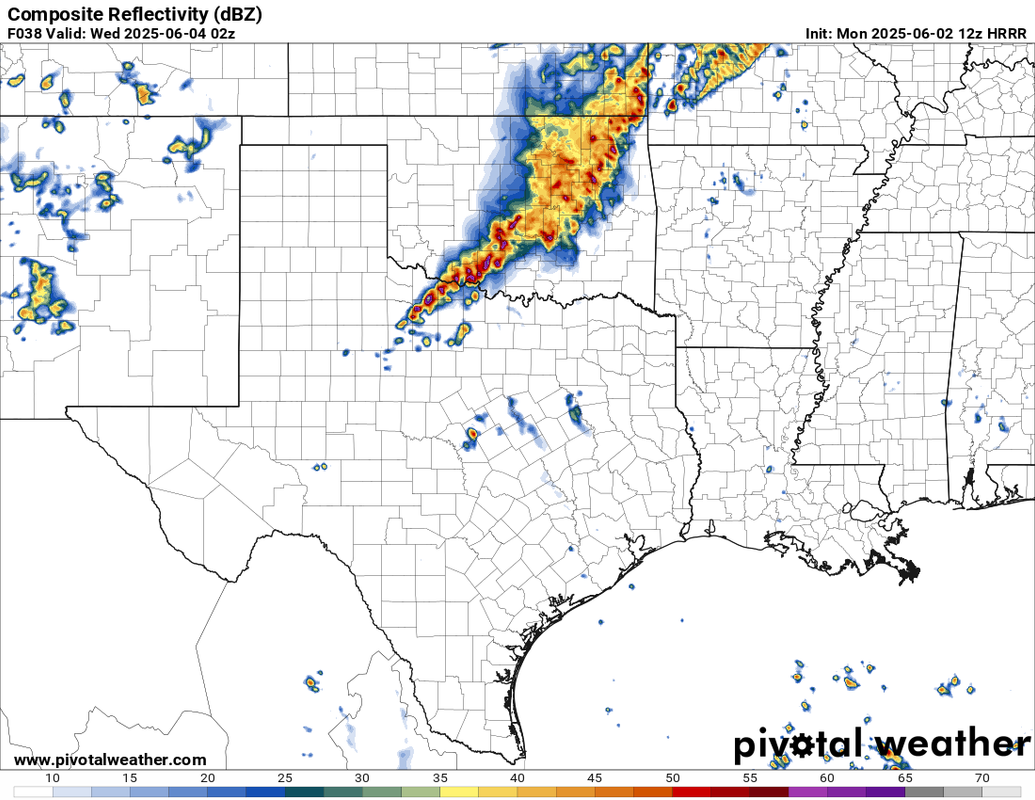
Good support from the CAM’s for a potent squall line here tomorrow evening. Wouldn’t be surprised to see an upgrade to Enhanced Risk eventually.


0 likes


-
CaptinCrunch
- S2K Supporter
- Posts: 8777
- Age: 58
- Joined: Mon Nov 03, 2003 4:33 pm
- Location: Kennedale, TX (Tarrant Co.)
Re: Texas Summer 2025
Cpv17 wrote:
The 0z really cut back on those totals lol
Looks like the Winter Snow accumulation maps, over done from start to finish.
2 likes
-
wxman22
- Category 5
- Posts: 1897
- Joined: Mon Jan 30, 2006 12:39 am
- Location: Wichita Falls, TX
- Contact:
Re: Texas Summer 2025
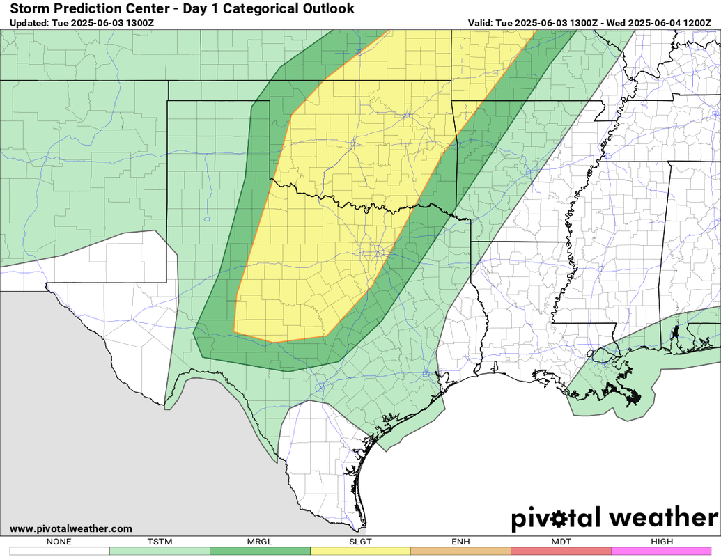
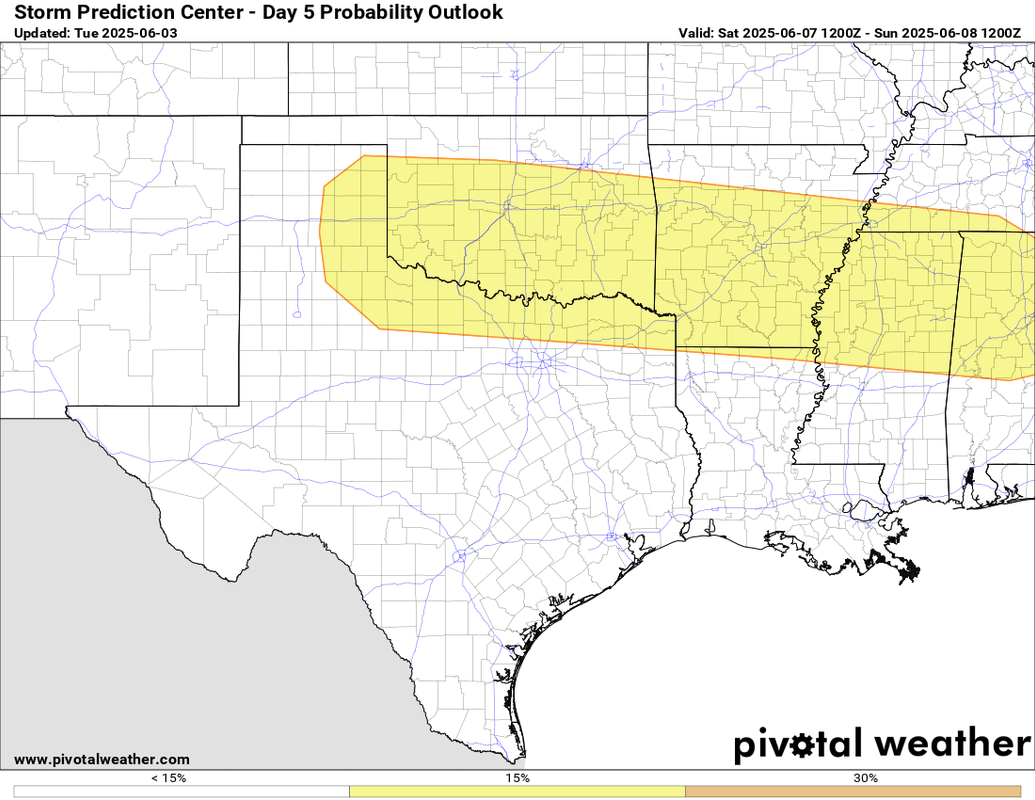
As expected the SPC mentioned in the afternoon update the possibility of an Enhanced Risk for wind tomorrow.
..Central Texas to the Ozarks...
Modestly enhanced/focused forcing for ascent preceding the
southern-stream shortwave trough and weak lee cyclone over the
southern/central Plains will support numerous bands of
eastward-moving thunderstorms during the afternoon into the
evening/overnight hours. While overnight convection and related
boundary-layer overturning is expected here, diurnal heating of an
increasingly moist boundary layer (lower 70s dewpoints) will still
yield moderate surface-based buoyancy. This, combined with 30-40 kt
of effective shear, will support a mix of supercell clusters and
organized line segments -- capable of producing scattered severe
wind gusts, large hail, and possibly a couple embedded tornadoes.
While there does appear to be a focused/favorable corridor for
swaths of severe wind with upscale-growing convection (especially
over the central/southern Plains), early-day storms limit confidence
in the overall convective evolution -- precluding an upgrade to
30-percent wind/ENH at this time.
0 likes

-
HockeyTx82
- S2K Supporter
- Posts: 2785
- Joined: Tue Oct 27, 2009 11:17 am
- Location: Ponder, TX
Re: Texas Summer 2025
This moring stuff plus cloud cover I assume would lesson our threat later on for DFW?
0 likes
Don't hold me accountable for anything I post on this forum. Leave the real forecasting up to the professionals.
Location: Ponder, TX (all observation posts are this location unless otherwise noted)
Location: Ponder, TX (all observation posts are this location unless otherwise noted)
-
rwfromkansas
- Category 5
- Posts: 3026
- Joined: Sat Aug 27, 2005 12:47 am
- Location: North Fort Worth
Re: Texas Summer 2025
HockeyTx82 wrote:This moring stuff plus cloud cover I assume would lesson our threat later on for DFW?
Likely not the evening squall line but other stuff probably. It’s not much so I don’t see a big impact. Just light rain mostly now. No big outflow.
0 likes
-
wxman22
- Category 5
- Posts: 1897
- Joined: Mon Jan 30, 2006 12:39 am
- Location: Wichita Falls, TX
- Contact:
Re: Texas Summer 2025
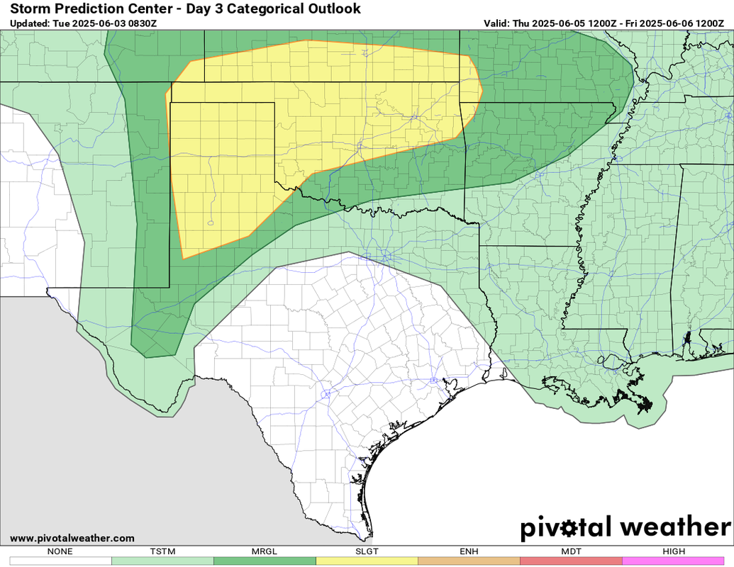
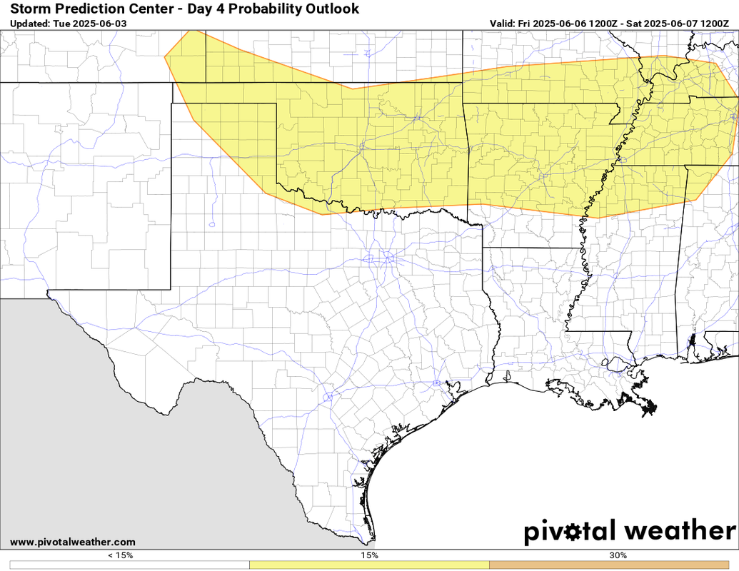
Busy week ahead for the southern plains with several opportunities for severe weather this week starting today.
0 likes

-
HockeyTx82
- S2K Supporter
- Posts: 2785
- Joined: Tue Oct 27, 2009 11:17 am
- Location: Ponder, TX
Re: Texas Summer 2025
wxman22 wrote:https://i.ibb.co/V0RxpLc5/IMG-0477.png
A watch dropped but much more further north than that box would have indicated.
0 likes
Don't hold me accountable for anything I post on this forum. Leave the real forecasting up to the professionals.
Location: Ponder, TX (all observation posts are this location unless otherwise noted)
Location: Ponder, TX (all observation posts are this location unless otherwise noted)


Re: Texas Summer 2025
Ensembles medium-long range is showing signs of troughing along the Pac NW and west coast. Inversely would support a ridge mid June, so we would likely start to see our first extended heat. Not all that unusual though given that will be approaching the summer solstice. Get as much rain as you can the next 1-2 weeks.
0 likes
The above post and any post by Ntxw is NOT an official forecast and should not be used as such. It is just the opinion of the poster and may or may not be backed by sound meteorological data. It is NOT endorsed by any professional institution including Storm2k. For official information, please refer to NWS products.
Help support Storm2K!
-
wxman22
- Category 5
- Posts: 1897
- Joined: Mon Jan 30, 2006 12:39 am
- Location: Wichita Falls, TX
- Contact:
Re: Texas Summer 2025
Wow what a storm! Winds have been gusting to hurricane force for 15+ mins with nickel size hail. Have some large branches down.And powerlines are down blocking some highways. Strongest storm I’ve seen so far this year wind wise! I love the weather up here lol.
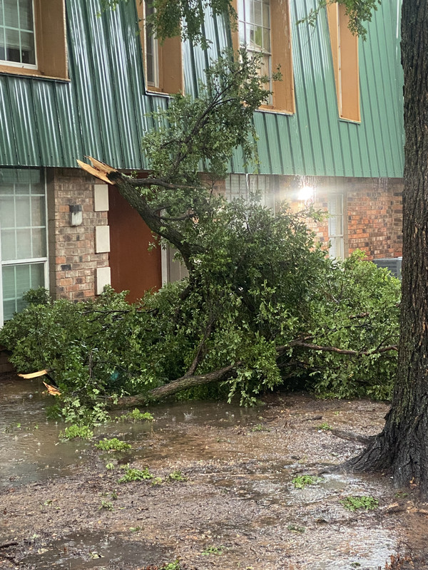
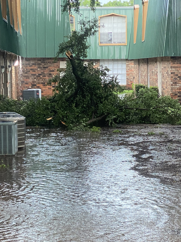
3 likes
Re: Texas Summer 2025
Ntxw wrote:Ensembles medium-long range is showing signs of troughing along the Pac NW and west coast. Inversely would support a ridge mid June, so we would likely start to see our first extended heat. Not all that unusual though given that will be approaching the summer solstice. Get as much rain as you can the next 1-2 weeks.
I’m really not too concerned yet about any death ridge parking itself over us for a long extended period of time.
1 likes
-
South Texas Storms

- Professional-Met

- Posts: 4256
- Joined: Thu Jun 24, 2010 12:28 am
- Location: Houston, TX
Re: Texas Summer 2025
Cpv17 wrote:Ntxw wrote:Ensembles medium-long range is showing signs of troughing along the Pac NW and west coast. Inversely would support a ridge mid June, so we would likely start to see our first extended heat. Not all that unusual though given that will be approaching the summer solstice. Get as much rain as you can the next 1-2 weeks.
I’m really not too concerned yet about any death ridge parking itself over us for a long extended period of time.
Longer range models have been indicating south TX could see closer to normal temps and possibly above normal rainfall during the second half of June. The ridge could be far enough north to bring southern areas easterly flow which would open us up to any tropical waves moving westward across the Gulf.
2 likes

Return to “USA & Caribbean Weather”
Who is online
Users browsing this forum: A1A, CaptinCrunch, TomballEd and 116 guests