Texas Summer 2025
Moderator: S2k Moderators
Forum rules

The posts in this forum are NOT official forecast and should not be used as such. They are just the opinion of the poster and may or may not be backed by sound meteorological data. They are NOT endorsed by any professional institution or STORM2K.
-
rwfromkansas
- Category 5

- Posts: 3026
- Joined: Sat Aug 27, 2005 12:47 am
- Location: North Fort Worth
Re: Texas Summer 2025
rwfromkansas wrote:Wow, true derechos seem rare here. But, this looks legit...
Wasn't the last one June 2019?
0 likes
-
bubba hotep

- S2K Supporter

- Posts: 6013
- Joined: Wed Dec 28, 2016 1:00 am
- Location: Collin County Texas
Re: Texas Summer 2025
Quixotic wrote:Possible derecho tomorrow?
I smell what you're cooking
1 likes
Winter time post are almost exclusively focused on the DFW area.
-
wxman22

- Category 5
- Posts: 1902
- Joined: Mon Jan 30, 2006 12:39 am
- Location: Wichita Falls, TX
- Contact:
Re: Texas Summer 2025
I wouldn't be surprised if they expand the Moderate Risk into DFW.The late night Day 1 discussion will be interesting... and the 0Z CAM's also. Some of them are showing wind gust over 110 mph in some areas! Hopefully thats overdone.
2 likes
-
bubba hotep
- S2K Supporter
- Posts: 6013
- Joined: Wed Dec 28, 2016 1:00 am
- Location: Collin County Texas
Re: Texas Summer 2025
wxman22 wrote:I wouldn't be surprised if they expand the Moderate Risk into DFW.The late night Day 1 discussion will be interesting... and the 0Z CAM's also. Some of them are showing wind gust over 110 mph in some areas! Hopefully thats overdone.
Also, I wouldn't sleep on storms across North Texas this evening.
1 likes
Winter time post are almost exclusively focused on the DFW area.


Re: Texas Summer 2025
wxman22 wrote:I wouldn't be surprised if they expand the Moderate Risk into DFW.The late night Day 1 discussion will be interesting... and the 0Z CAM's also. Some of them are showing wind gust over 110 mph in some areas! Hopefully thats overdone.
I expect that the SPC update will expand the moderate risk. The instability combined with the shear are ripe ingredients for bowing out. Whether it meets official derecho criteria remains to be seen but this is the most significant wind threat I’ve seen in a while.
1 likes
-
HockeyTx82
- S2K Supporter
- Posts: 2787
- Joined: Tue Oct 27, 2009 11:17 am
- Location: Ponder, TX
Re: Texas Summer 2025
I guess my question is how often do we see such extremes and then how often do such extremes actually occur?
And I assume this is a Leading Edge once the storm blows through we're done type scenario, so if you don't get it on the first go through then you won't get anything?
And I assume this is a Leading Edge once the storm blows through we're done type scenario, so if you don't get it on the first go through then you won't get anything?
0 likes
Don't hold me accountable for anything I post on this forum. Leave the real forecasting up to the professionals.
Location: Ponder, TX (all observation posts are this location unless otherwise noted)
Location: Ponder, TX (all observation posts are this location unless otherwise noted)
Re: Texas Summer 2025
HockeyTx82 wrote:I guess my question is how often do we see such extremes and then how often do such extremes actually occur?
And I assume this is a Leading Edge once the storm blows through we're done type scenario, so if you don't get it on the first go through then you won't get anything?
I’d say this is more rare than Tornadoes. Immediately, this is a one and done but from what I’m seeing outflow boundaries will be around for the next few days that will provide focus for more development.
Anecdotal but I remember an event like this in the mid 90s. I woke up around noon in my parents house which was about 60 years old and long settled and well made. It was groaning. The setup tomorrow caused 100mph winds that caused that old brick house to move enough to make noise. Recall that windows were blown out downtown.
0 likes
-
HockeyTx82
- S2K Supporter
- Posts: 2787
- Joined: Tue Oct 27, 2009 11:17 am
- Location: Ponder, TX
Re: Texas Summer 2025
Quixotic wrote:HockeyTx82 wrote:I guess my question is how often do we see such extremes and then how often do such extremes actually occur?
And I assume this is a Leading Edge once the storm blows through we're done type scenario, so if you don't get it on the first go through then you won't get anything?
I’d say this is more rare than Tornadoes. Immediately, this is a one and done but from what I’m seeing outflow boundaries will be around for the next few days that will provide focus for more development.
Anecdotal but I remember an event like this in the mid 90s. I woke up around noon in my parents house which was about 60 years old and long settled and well made. It was groaning. The setup tomorrow caused 100mph winds that caused that old brick house to move enough to make noise. Recall that windows were blown out downtown.
What about the models actually showing something like this and what is the actual hit rate on them being correct?
0 likes
Don't hold me accountable for anything I post on this forum. Leave the real forecasting up to the professionals.
Location: Ponder, TX (all observation posts are this location unless otherwise noted)
Location: Ponder, TX (all observation posts are this location unless otherwise noted)
-
South Texas Storms

- Professional-Met

- Posts: 4256
- Joined: Thu Jun 24, 2010 12:28 am
- Location: Houston, TX
Re: Texas Summer 2025
After being impacted by a derecho last year in Houston, I never want to experience that again. Hope our north TX friends stay safe tomorrow night. I'm expecting widespread gusts of 50-70 mph across north TX and southern OK, with isolated areas seeing up to 100 mph winds. Not fun.
2 likes
-
Brent
- S2K Supporter
- Posts: 38729
- Age: 37
- Joined: Sun May 16, 2004 10:30 pm
- Location: Tulsa Oklahoma
- Contact:
Re: Texas Summer 2025
South Texas Storms wrote:After being impacted by a derecho last year in Houston, I never want to experience that again. Hope our north TX friends stay safe tomorrow night. I'm expecting widespread gusts of 50-70 mph across north TX and southern OK, with isolated areas seeing up to 100 mph winds. Not fun.
Yeah the one here in 2023 was the worst thing I've ever seen and I mean I went through the worst tornado outbreak in 50 years in Alabama and softball sized hail in DFW once.... Nothing ever did that much damage on a wide scale for days or even weeks in some areas. Most of the city was completely trashed
I am good
The good news is they are rare and take an absolutely perfect setup
0 likes
#neversummer


Re: Texas Summer 2025
HockeyTx82 wrote:Quixotic wrote:HockeyTx82 wrote:I guess my question is how often do we see such extremes and then how often do such extremes actually occur?
And I assume this is a Leading Edge once the storm blows through we're done type scenario, so if you don't get it on the first go through then you won't get anything?
I’d say this is more rare than Tornadoes. Immediately, this is a one and done but from what I’m seeing outflow boundaries will be around for the next few days that will provide focus for more development.
Anecdotal but I remember an event like this in the mid 90s. I woke up around noon in my parents house which was about 60 years old and long settled and well made. It was groaning. The setup tomorrow caused 100mph winds that caused that old brick house to move enough to make noise. Recall that windows were blown out downtown.
What about the models actually showing something like this and what is the actual hit rate on them being correct?
We usually see one or two big derecho/MCS type event with 70mph+ gusts annually, lately early June has delivered. Every few years there's a big one that downs a lot of foliage in an area.
0 likes
The above post and any post by Ntxw is NOT an official forecast and should not be used as such. It is just the opinion of the poster and may or may not be backed by sound meteorological data. It is NOT endorsed by any professional institution including Storm2k. For official information, please refer to NWS products.
Help support Storm2K!
-
wxman22
- Category 5
- Posts: 1902
- Joined: Mon Jan 30, 2006 12:39 am
- Location: Wichita Falls, TX
- Contact:
Re: Texas Summer 2025
South Texas Storms wrote:After being impacted by a derecho last year in Houston, I never want to experience that again. Hope our north TX friends stay safe tomorrow night. I'm expecting widespread gusts of 50-70 mph across north TX and southern OK, with isolated areas seeing up to 100 mph winds. Not fun.
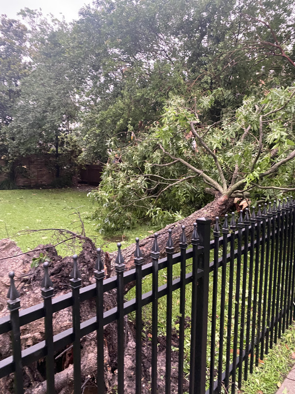
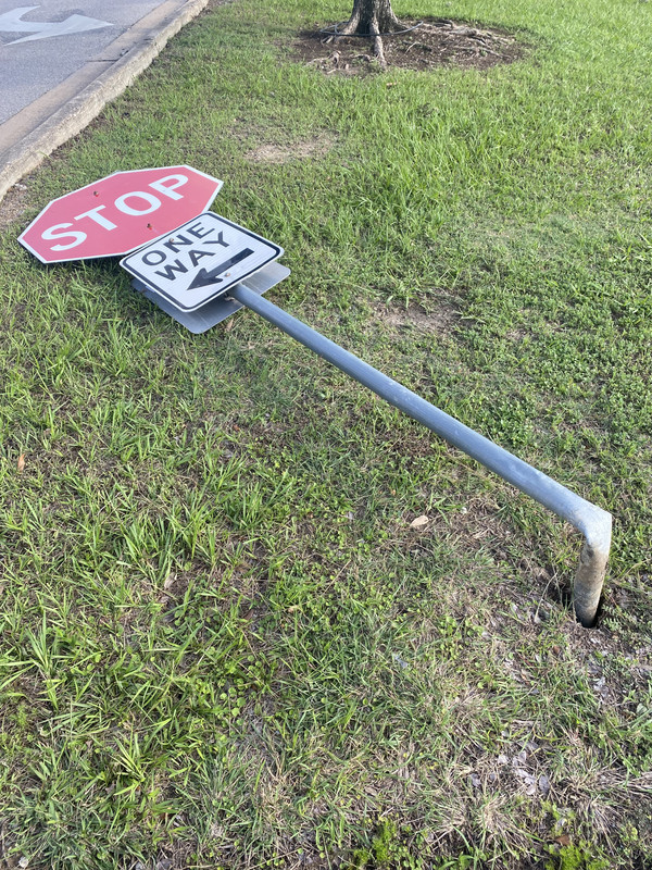
I was without power for 3 days from that storm.It was terrible, trees down and uprooted all over the neighborhood (The Heights). Here's a couple of pics a took after the storm.


Last edited by wxman22 on Sat Jun 07, 2025 9:09 pm, edited 3 times in total.
1 likes
Re: Texas Summer 2025
Last derecho I remember here in DFW was around June 2023. I happened to be at the airport when the firsts gusts started to blow in from the west. Construction barrels and other debris were flying all over the place. Pretty wild scene though the rain wasn't all that heavy. Another one I remember was around 2014 and I was driving from Ft. Worth to Grand Prairie on I20 with sunshine if front of me and flying debris and dark clouds behind me. The rain was heavier with that one. Made it home just as it was coming through. Limbs were strewn all over the neighborhood.
0 likes
Re: Texas Summer 2025
South Texas Storms wrote:After being impacted by a derecho last year in Houston, I never want to experience that again. Hope our north TX friends stay safe tomorrow night. I'm expecting widespread gusts of 50-70 mph across north TX and southern OK, with isolated areas seeing up to 100 mph winds. Not fun.
DFW also got hit hard on 5/28 last year. Over 6000K lost power including myself (the worst event in Oncor's history) with widespread 70-90 MPH winds, 5am in the morning at that.
On top of that, the wake winds were impressive too. Had a couple hours with post-storm wind gusts of 40-50 MPH.
However, it technically wasn't a derecho.
0 likes
-
wxman22
- Category 5
- Posts: 1902
- Joined: Mon Jan 30, 2006 12:39 am
- Location: Wichita Falls, TX
- Contact:
Re: Texas Summer 2025
snownado wrote:South Texas Storms wrote:After being impacted by a derecho last year in Houston, I never want to experience that again. Hope our north TX friends stay safe tomorrow night. I'm expecting widespread gusts of 50-70 mph across north TX and southern OK, with isolated areas seeing up to 100 mph winds. Not fun.
DFW also got hit hard on 5/28 last year. Over 6000K lost power including myself (the worst event in Oncor's history) with widespread 70-90 MPH winds, 5am in the morning at that.
On top of that, the wake winds were impressive too. Had a couple hours with post-storm wind gusts of 50 MPH, which even promoted an extremely rare High Wind Warning.
However, it technically wasn't a derecho.
We were under a High Wind Warning last night here from outflow from the dying storm complex. This was the 4th High Wind Warning this year here.Which is not common based on the data I've seen. Its been a windy year.

0 likes
-
Iceresistance

- Category 5
- Posts: 9579
- Age: 22
- Joined: Sat Oct 10, 2020 9:45 am
- Location: Tecumseh, OK/Norman, OK
Re: Texas Summer 2025
0 likes
Bill 2015 & Beta 2020
Winter 2020-2021
All observations are in Tecumseh, OK unless otherwise noted.
Winter posts are focused mainly for Oklahoma & Texas.
Take any of my forecasts with a grain of salt, refer to the NWS, SPC, and NHC for official information
Never say Never with weather! Because ANYTHING is possible!
Winter 2020-2021
All observations are in Tecumseh, OK unless otherwise noted.
Winter posts are focused mainly for Oklahoma & Texas.
Take any of my forecasts with a grain of salt, refer to the NWS, SPC, and NHC for official information
Never say Never with weather! Because ANYTHING is possible!
-
rwfromkansas
- Category 5
- Posts: 3026
- Joined: Sat Aug 27, 2005 12:47 am
- Location: North Fort Worth
Re: Texas Summer 2025
Did some reading on derecho forecasting tonight. Looked at the HRRR, and holy smokes, it looks scary.
1600 DCAPE exceeding very high threhold.
4021 MUCAPE.
56 shear
Assuming I did the math right, which is iffy...tomorrow has a high Derecho Composite of around 6.
https://www.nssl.noaa.gov/users/mcon/pu ... iption.htm
1600 DCAPE exceeding very high threhold.
4021 MUCAPE.
56 shear
Assuming I did the math right, which is iffy...tomorrow has a high Derecho Composite of around 6.
https://www.nssl.noaa.gov/users/mcon/pu ... iption.htm
0 likes
-
wxman22
- Category 5
- Posts: 1902
- Joined: Mon Jan 30, 2006 12:39 am
- Location: Wichita Falls, TX
- Contact:
Re: Texas Summer 2025

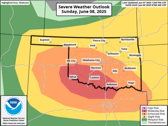
Day 1 Convective Outlook
NWS Storm Prediction Center Norman OK
0100 AM CDT Sun Jun 08 2025
Valid 081200Z - 091200Z
...THERE IS A MODERATE RISK OF SEVERE THUNDERSTORMS ACROSS PORTIONS
OF SOUTHERN OKLAHOMA INTO NORTHERN TEXAS...
...THERE IS A SLIGHT RISK OF SEVERE THUNDERSTORMS SEPARATELY ALONG
THE EAST COAST...
...SUMMARY...
A severe weather outbreak is possible across the southern Plains
today. A few tornadoes, destructive wind gusts of 80-100 mph, and
giant hail up to 5 inches in diameter are likely. Strong gusts, and
perhaps a couple of tornadoes, are also possible along portions of
the East Coast.
...Synopsis...
***A severe weather outbreak is possible across the southern Plains
today***
A broad mid-level trough will deepen across the Great Lakes into the
OH Valley, with multiple embedded mid-level impulses poised to pivot
around the upper trough across the southern Plains to the Southeast
and Atlantic Seaboard today. A broad northwesterly upper-flow regime
will become established across the Plains States into the MS Valley,
with modest mid-level flow contributing to strong deep-layer shear.
Beneath this stronger flow/shear and cold temperatures aloft will be
rich low-level moisture, which will support extreme instability,
especially in the southern Plains. Here, a volatile setup for severe
weather will exist. All severe hazards are expected, with
destructive wind gusts and giant hail likely. The severe threat
should persist to some degree into the Lower MS Valley after dark. A
severe risk will also accompany storms along parts of the East
Coast, as passing mid-level impulses provide enough lift and shear
atop a moist, unstable airmass.
...Southern Plains into the Lower MS Valley...
A diffuse baroclinic zone will be positioned across the TX
Panhandle, southeast into central or southern OK at the start of the
period. It is unclear how prolific convection will be during the
morning to early afternoon. Latest high-resolution model guidance
consensus suggests that these storms should not be overly intense,
nor should their impact on the free warm sector be overly
detrimental. Assuming this is the case, strong daytime heating, amid
some high level cirrus clouds, should support surface temperatures
reaching 90 F amid mid 70s F dewpoints. Given robust boundary layer
heating of this moisture beneath 8-9 C/km mid-level lapse rates,
widespread extreme buoyancy should develop by afternoon. Forecast
soundings show deep, wide CAPE profiles, with over 5000 J/kg MLCAPE
possible (perhaps locally higher in spots). At the same time, modest
veering with height in the lowest few hundred mb, and northwesterly
flow in the 500-200 mb increasing to 50-70 kts, will promote 50+ kts
of effective bulk shear (elongated hodographs with small low-level
curvature).
A quasi-stationary cold front will be draped somewhere along the
KS/OK border into MO, with a dryline positioned in far western TX
during the afternoon. With maximum daytime heating and minimal
MLCINH, robust convective initiation is expected along these
boundaries around mid-afternoon. Given the extreme buoyancy/shear
parameter space, the more isolated, discrete storms should quickly
become intense supercells capable of a few tornadoes, severe gusts
(perhaps exceeding 75 mph), and large hail. 2+ inch diameter hail
should become commonplace if multiple supercells can sustain
themselves, with giant hail (perhaps over 5 inches in diameter)
possible. Though much more conditional, an intense tornado could
develop somewhere in the eastern TX Panhandle if a longer-lived,
inflow-dominant supercell manages to materialize and optimally
ingest the extreme buoyancy while also traversing the diffuse
baroclinic boundary. However, confidence in this scenario is too low
for the introduction of higher tornado probabilities at this time.
At some point during the afternoon early evening, supercell cold
pool mergers should support the development of either one intense
MCS (perhaps in the form of a bow echo), or multiple small but
intense bowing segments. Should a bow echo form, widespread severe
winds are likely. In either scenario, gust magnitudes may
potentially reaching 80-100 mph, hence the maintenance of a Category
4/Moderate Risk. An MCS should progress toward the lower MS Valley
during the evening into the overnight, with a lingering severe wind
threat that should gradually subside with time.
0 likes
-
wxman22
- Category 5
- Posts: 1902
- Joined: Mon Jan 30, 2006 12:39 am
- Location: Wichita Falls, TX
- Contact:
Re: Texas Summer 2025
A severe weather outbreak is on the table tonight. Stay weather aware.


Day 1 Convective Outlook
NWS Storm Prediction Center Norman OK
0707 AM CDT Sun Jun 08 2025
Valid 081300Z - 091200Z
...THERE IS A MODERATE RISK OF SEVERE THUNDERSTORMS THIS AFTERNOON
AND EVENING FROM THE EASTERN TEXAS PANHANDLE INTO SOUTHERN OKLAHOMA
AND NORTHWEST/NORTH-CENTRAL TEXAS...
...THERE IS A SLIGHT RISK OF SEVERE THUNDERSTORMS THIS AFTERNOON
FROM THE MID-ATLANTIC REGION INTO GEORGIA....
...SUMMARY...
A severe weather outbreak is possible across the southern Plains
today. A few tornadoes, destructive wind gusts of 80-100 mph, and
giant hail up to 5 inches in diameter are likely. Strong gusts, and
perhaps a couple of tornadoes, are also possible along portions of
the East Coast.
...OK/TX...
Broad west-northwesterly flow is present today across the
central/southern Plains states, with a surface cold front sagging
southward across KS. Ahead of the front, a very moist
boundary-layer air mass is in place across much of OK and TX, with
dewpoints in the upper 60s and lower 70s. Strong daytime heating
and near dry-adiabatic low/mid-level lapse rates will yield a large
reservoir of extremely high CAPE values across western OK and
northwest TX.
Rapid development of intense thunderstorms will ensue by mid/late
afternoon along the cold front over northwest OK and along a complex
dryline structure over the eastern TX Panhandle. Strong deep layer
shear will favor supercells, despite rather weak low-level winds.
Very large hail, damaging winds, and a few tornadoes will be
possible as these storms track southeastward across western/central
OK and congeal into one or more bowing segments. Recent CAM
solutions suggest pockets of deep boundary-layer mixing, with some
areas heating into the mid 90s while dewpoints drop into the 50s.
If this scenario develops, significant wind and hail would remain a
concern, but the overall risk of tornadoes would be reduced.
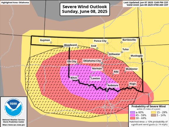
The risk of widespread destructive winds will increase through the
evening as the convective complex tracks into northwest and
north-central TX. The activity make remain intense as far east as
northern/central LA tonight.
0 likes
Return to “USA & Caribbean Weather”
Who is online
Users browsing this forum: MHTX5, SnowyOwl31 and 60 guests