Scoreboard:
EPAC 2 now with Barbara and maybe 3 very soon with 91E and more by next weekend while the North Atlantic basin is at 0.
2025 EPAC Season
Moderator: S2k Moderators
Forum rules

The posts in this forum are NOT official forecasts and should not be used as such. They are just the opinion of the poster and may or may not be backed by sound meteorological data. They are NOT endorsed by any professional institution or STORM2K. For official information, please refer to products from the National Hurricane Center and National Weather Service.
-
cycloneye

- Admin

- Posts: 149696
- Age: 69
- Joined: Thu Oct 10, 2002 10:54 am
- Location: San Juan, Puerto Rico
Re: 2025 EPAC Season
1 likes
Visit the Caribbean-Central America Weather Thread where you can find at first post web cams,radars
and observations from Caribbean basin members Click Here
and observations from Caribbean basin members Click Here
-
cycloneye
- Admin
- Posts: 149696
- Age: 69
- Joined: Thu Oct 10, 2002 10:54 am
- Location: San Juan, Puerto Rico
Re: 2025 EPAC Season
5 AM PDT:
South of Southern Mexico:
An area of low pressure is forecast to develop late next week south
of southern Mexico. Environmental conditions appear conducive for
some gradual development of this system, and a tropical depression
could form late this week.
* Formation chance through 48 hours...low...near 0 percent.
* Formation chance through 7 days...medium...40 percent.
0 likes
Visit the Caribbean-Central America Weather Thread where you can find at first post web cams,radars
and observations from Caribbean basin members Click Here
and observations from Caribbean basin members Click Here
-
Kingarabian

- S2K Supporter

- Posts: 16377
- Joined: Sat Aug 08, 2009 3:06 am
- Location: Honolulu, Hawaii
Re: 2025 EPAC Season
06z GFS not developing that 0/40 area. Has all the energy refocusing off the BOC.
1 likes
RIP Kobe Bryant
-
Category5Kaiju

- Category 5

- Posts: 4345
- Joined: Thu Dec 24, 2020 12:45 pm
- Location: Seattle during the summer, Phoenix during the winter
Re: 2025 EPAC Season
Ok, is anybody else getting this weird, grammar-error-riddled message on the NHC hurricane tracking website? Or is this just me?

1 likes
Unless explicitly stated, all information in my posts is based on my own opinions and observations. Tropical storms and hurricanes can be extremely dangerous. Refer to an accredited weather research agency or meteorologist if you need to make serious decisions regarding an approaching storm.
-
cycloneye
- Admin
- Posts: 149696
- Age: 69
- Joined: Thu Oct 10, 2002 10:54 am
- Location: San Juan, Puerto Rico
Re: 2025 EPAC Season
South of Southern Mexico:
An area of low pressure is forecast to develop later this week south
of southern Mexico. Environmental conditions appear conducive for
some gradual development of this system, and a tropical depression
could form late this week or over the weekend.
* Formation chance through 48 hours...low...near 0 percent.
* Formation chance through 7 days...medium...50 percent.
0 likes
Visit the Caribbean-Central America Weather Thread where you can find at first post web cams,radars
and observations from Caribbean basin members Click Here
and observations from Caribbean basin members Click Here
-
cycloneye
- Admin
- Posts: 149696
- Age: 69
- Joined: Thu Oct 10, 2002 10:54 am
- Location: San Juan, Puerto Rico
Re: 2025 EPAC Season
Kingarabian wrote:06z GFS not developing that 0/40 area. Has all the energy refocusing off the BOC.
At 12z it develops the 0/50 one as well on the other side.

3 likes
Visit the Caribbean-Central America Weather Thread where you can find at first post web cams,radars
and observations from Caribbean basin members Click Here
and observations from Caribbean basin members Click Here
-
Category5Kaiju
- Category 5
- Posts: 4345
- Joined: Thu Dec 24, 2020 12:45 pm
- Location: Seattle during the summer, Phoenix during the winter
Re: 2025 EPAC Season
The EPAC has now generated more NSs than the WPAC and the Atlantic combined. 
2 likes
Unless explicitly stated, all information in my posts is based on my own opinions and observations. Tropical storms and hurricanes can be extremely dangerous. Refer to an accredited weather research agency or meteorologist if you need to make serious decisions regarding an approaching storm.
-
cycloneye
- Admin
- Posts: 149696
- Age: 69
- Joined: Thu Oct 10, 2002 10:54 am
- Location: San Juan, Puerto Rico
Re: 2025 EPAC Season
Here comes Dalila. 18z simulated GFS run has a fairly strong cane from the 0/50 AOI that looks to make landfall near Manzanillo, Mexico.

1 likes
Visit the Caribbean-Central America Weather Thread where you can find at first post web cams,radars
and observations from Caribbean basin members Click Here
and observations from Caribbean basin members Click Here
-
cycloneye
- Admin
- Posts: 149696
- Age: 69
- Joined: Thu Oct 10, 2002 10:54 am
- Location: San Juan, Puerto Rico
Re: 2025 EPAC Season
5 PM PDT:


South of Southern Mexico:
An area of low pressure is forecast to develop later this week south
of southern Mexico. Environmental conditions appear conducive for
some gradual development of this system, and a tropical depression
could form late this week or over the weekend.
* Formation chance through 48 hours...low...near 0 percent.
* Formation chance through 7 days...medium...50 percent
1 likes
Visit the Caribbean-Central America Weather Thread where you can find at first post web cams,radars
and observations from Caribbean basin members Click Here
and observations from Caribbean basin members Click Here
-
Kingarabian
- S2K Supporter
- Posts: 16377
- Joined: Sat Aug 08, 2009 3:06 am
- Location: Honolulu, Hawaii
Re: 2025 EPAC Season
12z model suite showing one more for the EPAC after the 0/60 AOI.
1 likes
RIP Kobe Bryant
-
Yellow Evan

- Professional-Met

- Posts: 16257
- Age: 27
- Joined: Fri Jul 15, 2011 12:48 pm
- Location: Henderson, Nevada/Honolulu, HI
- Contact:
Re: 2025 EPAC Season
Incoming WWB should allow for cyclonic vorticity advection further south and potentially more time over favorable thermodynamics as a result.
2 likes
-
cycloneye
- Admin
- Posts: 149696
- Age: 69
- Joined: Thu Oct 10, 2002 10:54 am
- Location: San Juan, Puerto Rico
Re: 2025 EPAC Season
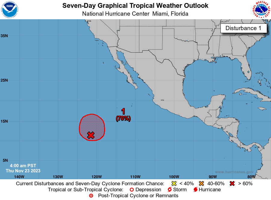
South of Southern Mexico:
An area of low pressure is forecast to develop later this week south
of southern Mexico. Environmental conditions appear conducive for
gradual development of this system, and a tropical depression is
likely to form late this week or over the weekend.
* Formation chance through 48 hours...low...near 0 percent.
* Formation chance through 7 days...high...70 percent.
1 likes
Visit the Caribbean-Central America Weather Thread where you can find at first post web cams,radars
and observations from Caribbean basin members Click Here
and observations from Caribbean basin members Click Here
-
cycloneye
- Admin
- Posts: 149696
- Age: 69
- Joined: Thu Oct 10, 2002 10:54 am
- Location: San Juan, Puerto Rico
Re: 2025 EPAC Season
11 PM PDT:
South of Southern Mexico:
An area of low pressure is forecast to develop later this week south
of southern Mexico. Environmental conditions appear conducive for
gradual development of this system, and a tropical depression is
likely to form late this week or over the weekend.
* Formation chance through 48 hours...low...near 0 percent.
* Formation chance through 7 days...high...70 percent.
An area of low pressure is forecast to develop later this week south
of southern Mexico. Environmental conditions appear conducive for
gradual development of this system, and a tropical depression is
likely to form late this week or over the weekend.
* Formation chance through 48 hours...low...near 0 percent.
* Formation chance through 7 days...high...70 percent.
0 likes
Visit the Caribbean-Central America Weather Thread where you can find at first post web cams,radars
and observations from Caribbean basin members Click Here
and observations from Caribbean basin members Click Here

2025 Global Model Runs Discussion (Out thru day 16)
Very active 00z EPS for the EPAC. Multiple members show 1 or 2 strong hurricanes and 2 members even go as low as 930 mb.


1 likes
-
cycloneye
- Admin
- Posts: 149696
- Age: 69
- Joined: Thu Oct 10, 2002 10:54 am
- Location: San Juan, Puerto Rico
Re: 2025 EPAC Season
5 AM PDT:
South of Southern Mexico:
An area of low pressure is forecast to develop later this week south
of southern Mexico. Environmental conditions appear conducive for
gradual development of this system, and a tropical depression is
likely to form late this week or over the weekend while moving
generally west-northwestward just offshore the southwestern coast
of Mexico.
* Formation chance through 48 hours...low...near 0 percent.
* Formation chance through 7 days...high...70 percent.
0 likes
Visit the Caribbean-Central America Weather Thread where you can find at first post web cams,radars
and observations from Caribbean basin members Click Here
and observations from Caribbean basin members Click Here
-
cycloneye
- Admin
- Posts: 149696
- Age: 69
- Joined: Thu Oct 10, 2002 10:54 am
- Location: San Juan, Puerto Rico
Re: 2025 Global Model Runs Discussion (Out thru day 16)
kevin wrote:Very active 00z EPS for the EPAC. Multiple members show 1 or 2 strong hurricanes and 2 members even go as low as 930 mb.
https://i.imgur.com/af5FhL8.png
https://i.imgur.com/vjGwRnH.png
Hi kevin. Moved your EPS post to this EPAC thread as the topic you bring is for that basin.
1 likes
Visit the Caribbean-Central America Weather Thread where you can find at first post web cams,radars
and observations from Caribbean basin members Click Here
and observations from Caribbean basin members Click Here
-
Kingarabian
- S2K Supporter
- Posts: 16377
- Joined: Sat Aug 08, 2009 3:06 am
- Location: Honolulu, Hawaii
Re: 2025 EPAC Season
Looks like what ever caused that coastal El Niño is aiding rising motion in the far eastern pacific which is aiding TCG at a rapid rate.
0 likes
RIP Kobe Bryant
-
Yellow Evan
- Professional-Met
- Posts: 16257
- Age: 27
- Joined: Fri Jul 15, 2011 12:48 pm
- Location: Henderson, Nevada/Honolulu, HI
- Contact:
Re: 2025 EPAC Season
0 likes
-
Kingarabian
- S2K Supporter
- Posts: 16377
- Joined: Sat Aug 08, 2009 3:06 am
- Location: Honolulu, Hawaii
Re: 2025 EPAC Season
Yellow Evan wrote::uarrow: We’d be seeing lower latitude genesis if this was driven by weak trades along the equator. This may change a bit next week but for now the trade anomalies have been displaced further north.
Weak trades at the equator are either superceded by -VP 200 anomalies or those -VP 200 anomalies setup right after. Which is why you can have development near 10N/10S.
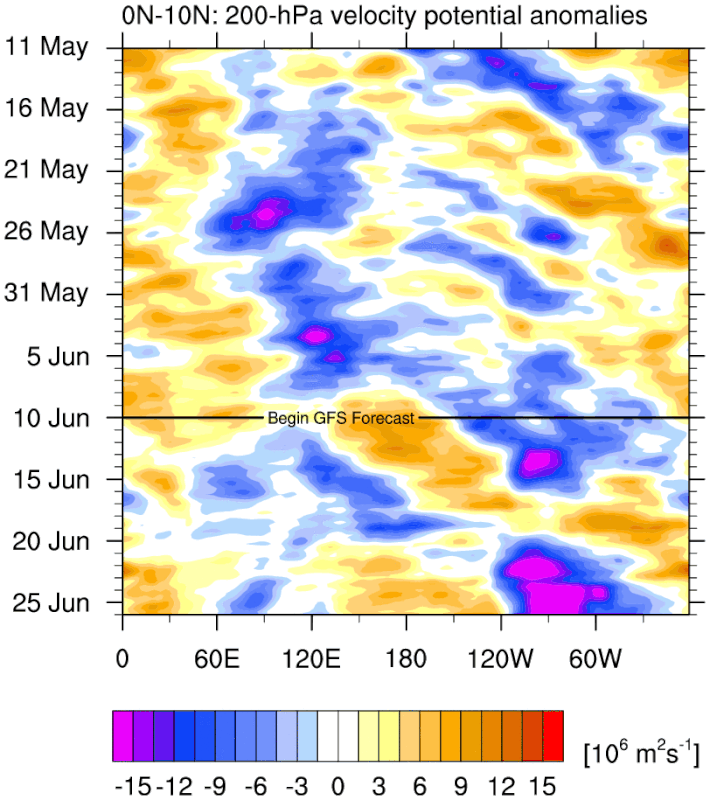
The cause of this outbreak in EPAC activity seems to be related to whatever mechanism that caused Nino 1+2 to warm up.
0 likes
RIP Kobe Bryant
-
cycloneye
- Admin
- Posts: 149696
- Age: 69
- Joined: Thu Oct 10, 2002 10:54 am
- Location: San Juan, Puerto Rico
Re: 2025 EPAC Season
For the record of thread. 11 AM TWO:
South of Southern Mexico:
A broad area of low pressure located several hundred miles south of
the Gulf of Tehuantepec is producing disorganized shower and
thunderstorm activity. Environmental conditions appear conducive
for gradual development of this system, and a tropical depression is
likely to form late this week or over the weekend while moving
generally west-northwestward just offshore the southwestern coast
of Mexico.
* Formation chance through 48 hours...low...10 percent.
* Formation chance through 7 days...high...80 percent.
0 likes
Visit the Caribbean-Central America Weather Thread where you can find at first post web cams,radars
and observations from Caribbean basin members Click Here
and observations from Caribbean basin members Click Here
Who is online
Users browsing this forum: No registered users and 196 guests