BULLETIN
Tropical Storm Dalila Intermediate Advisory Number 11A
NWS National Hurricane Center Miami FL EP042025
500 AM MST Sun Jun 15 2025
...DALILA MOVING AWAY FROM THE COAST OF SOUTHWESTERN
MEXICO...
...ALL TROPICAL STORM WARNINGS DISCONTINUED...
SUMMARY OF 500 AM MST...1200 UTC...INFORMATION
----------------------------------------------
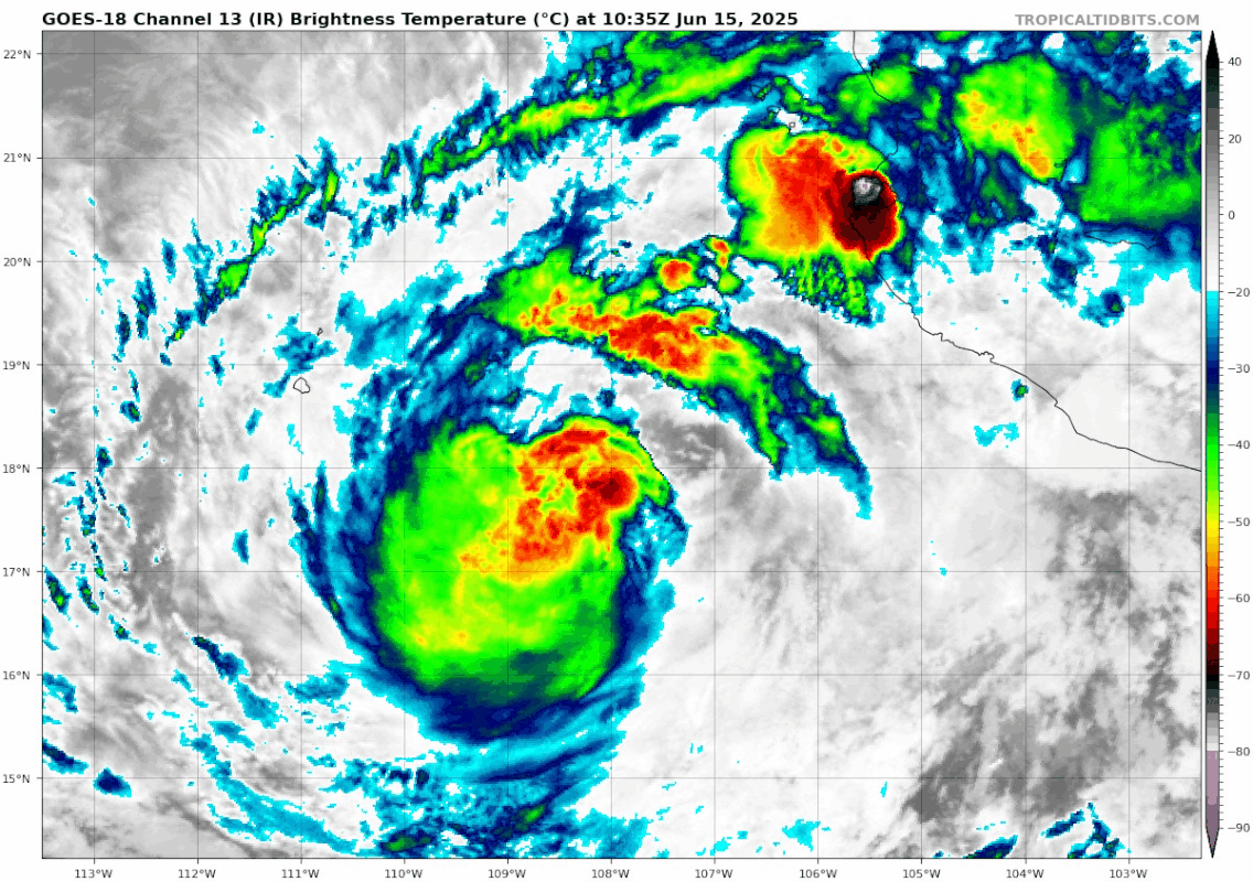
LOCATION...18.1N 107.4W
ABOUT 215 MI...340 KM WSW OF MANZANILLO MEXICO
MAXIMUM SUSTAINED WINDS...60 MPH...95 KM/H
PRESENT MOVEMENT...WNW OR 285 DEGREES AT 14 MPH...22 KM/H
MINIMUM CENTRAL PRESSURE...996 MB...29.42 INCHES
EPAC: DALILA - Post-Tropical - Discussion
Moderator: S2k Moderators
-
cycloneye

- Admin

- Posts: 149721
- Age: 69
- Joined: Thu Oct 10, 2002 10:54 am
- Location: San Juan, Puerto Rico
Re: EPAC: DALILA - Tropical Storm - Discussion
0 likes
Visit the Caribbean-Central America Weather Thread where you can find at first post web cams,radars
and observations from Caribbean basin members Click Here
and observations from Caribbean basin members Click Here


Re: EPAC: DALILA - Tropical Storm - Discussion
Poof?
1 likes
TC naming lists: retirements and intensity
Most aggressive Advisory #1's in North Atlantic (cr. kevin for starting the list)
Most aggressive Advisory #1's in North Atlantic (cr. kevin for starting the list)
-
cycloneye
- Admin
- Posts: 149721
- Age: 69
- Joined: Thu Oct 10, 2002 10:54 am
- Location: San Juan, Puerto Rico
Re: EPAC: DALILA - Tropical Storm - Discussion
Tropical Storm Dalila Discussion Number 12
NWS National Hurricane Center Miami FL EP042025
800 AM MST Sun Jun 15 2025
Dalila's satellite appearance has degraded since the previous
advisory. Cloud tops have been warming, and what convection remains
is displaced to the southwest. First-light visible imagery showed
that the system has decoupled with the low-level center exposed due
to moderate northeasterly wind shear. Given the current satellite
presentation, subjective and objective intensity estimates have
started to drop-off, and the initial intensity is lowered to 45 kt
for this advisory.
Dalila is moving towards the west-northwest, at an estimated 295/8
kt. As Dalila continues to weaken and becomes a shallower vortex, a
turn towards the west is expected within the low-level wind flow.
The current NHC track forecast is similar to the previous, near the
consensus aids.
The storm will continue to weaken today within a cooler SSTs and a
drier, more stable environment. Dalila is already struggling to
produce convection and should become a post-tropical cyclone later
tonight. The latest intensity forecast shows steady weakening and
the system dissipating in a couple of days.
FORECAST POSITIONS AND MAX WINDS
INIT 15/1500Z 18.2N 107.8W 45 KT 50 MPH
12H 16/0000Z 18.3N 109.1W 35 KT 40 MPH...POST-TROPICAL
24H 16/1200Z 18.3N 110.8W 30 KT 35 MPH...POST-TROP/REMNT LOW
36H 17/0000Z 18.2N 112.5W 25 KT 30 MPH...POST-TROP/REMNT LOW
48H 17/1200Z 18.2N 114.4W 20 KT 25 MPH...POST-TROP/REMNT LOW
60H 18/0000Z...DISSIPATED
$$
Forecaster Kelly
0 likes
Visit the Caribbean-Central America Weather Thread where you can find at first post web cams,radars
and observations from Caribbean basin members Click Here
and observations from Caribbean basin members Click Here
-
cycloneye
- Admin
- Posts: 149721
- Age: 69
- Joined: Thu Oct 10, 2002 10:54 am
- Location: San Juan, Puerto Rico
Re: EPAC: DALILA - Tropical Storm - Discussion
Tropical Storm Dalila Discussion Number 13
NWS National Hurricane Center Miami FL EP042025
200 PM MST Sun Jun 15 2025
Dalila's convection has collapsed, leaving behind a single
fragmented band of thunderstorms. Subjective and objective
satellite estimates have lowered this cycle and the initial
intensity has been reduced to 40 kt based on a blend of the TAFB and
SAB Dvorak estimates. Dalila is expected to continue weakening as
the storm moves over cooler waters and into a hostile environment.
The NHC intensity forecast predicts Dalila to become a post-tropical
remnant low later today.
The storm is moving west-northwestward at 8 kt and should continue
gradually turning westward in the low-level flow. A more westward
motion is expected in the next day or two until the system
dissipates in a couple of days.
FORECAST POSITIONS AND MAX WINDS
INIT 15/2100Z 18.2N 108.4W 40 KT 45 MPH
12H 16/0600Z 18.3N 109.6W 30 KT 35 MPH...POST-TROP/REMNT LOW
24H 16/1800Z 18.3N 111.3W 25 KT 30 MPH...POST-TROP/REMNT LOW
36H 17/0600Z 18.2N 113.1W 25 KT 30 MPH...POST-TROP/REMNT LOW
48H 17/1800Z 18.2N 115.0W 20 KT 25 MPH...POST-TROP/REMNT LOW
60H 18/0600Z...DISSIPATED
$$
Forecaster Bucci
0 likes
Visit the Caribbean-Central America Weather Thread where you can find at first post web cams,radars
and observations from Caribbean basin members Click Here
and observations from Caribbean basin members Click Here
-
cycloneye
- Admin
- Posts: 149721
- Age: 69
- Joined: Thu Oct 10, 2002 10:54 am
- Location: San Juan, Puerto Rico
Re: EPAC: DALILA - Post-Tropical - Discussion
BULLETIN
Post-Tropical Cyclone Dalila Advisory Number 14
NWS National Hurricane Center Miami FL EP042025
800 PM MST Sun Jun 15 2025
...DALILA BECOMES POST-TROPICAL...
...THIS IS THE LAST NHC ADVISORY ON DALILA...
SUMMARY OF 800 PM MST...0300 UTC...INFORMATION
----------------------------------------------
LOCATION...18.6N 109.2W
ABOUT 320 MI...515 KM W OF MANZANILLO MEXICO
MAXIMUM SUSTAINED WINDS...35 MPH...55 KM/H
PRESENT MOVEMENT...WNW OR 285 DEGREES AT 9 MPH...15 KM/H
MINIMUM CENTRAL PRESSURE...1004 MB...29.65 INCHES
0 likes
Visit the Caribbean-Central America Weather Thread where you can find at first post web cams,radars
and observations from Caribbean basin members Click Here
and observations from Caribbean basin members Click Here
Who is online
Users browsing this forum: No registered users and 72 guests