EPAC: ERICK - Post-Tropical - Discussion
Moderator: S2k Moderators
-
Yellow Evan

- Professional-Met

- Posts: 16240
- Age: 27
- Joined: Fri Jul 15, 2011 12:48 pm
- Location: Henderson, Nevada/Honolulu, HI
- Contact:
Re: EPAC: FIVE-E - Potential Tropical Cyclone - Discussion Update=00z Best Track as TD
With genesis tonight, this give us a 60-72 hour window to intensify under high moisture, low shear, a great outflow pattern and high ocean temperatures.
1 likes
-
cycloneye

- Admin

- Posts: 149464
- Age: 69
- Joined: Thu Oct 10, 2002 10:54 am
- Location: San Juan, Puerto Rico
Re: EPAC: FIVE-E - Tropical Depression - Discussion
BULLETIN
Tropical Depression Five-E Advisory Number 2
NWS National Hurricane Center Miami FL EP052025
900 PM CST Mon Jun 16 2025
...HURRICANE WATCH ISSUED FOR PORTIONS OF SOUTHERN MEXICO...
SUMMARY OF 900 PM CST...0300 UTC...INFORMATION
----------------------------------------------
LOCATION...11.2N 92.6W
ABOUT 535 MI...860 KM SE OF PUNTA MALDONADO MEXICO
MAXIMUM SUSTAINED WINDS...35 MPH...55 KM/H
PRESENT MOVEMENT...WNW OR 300 DEGREES AT 12 MPH...19 KM/H
MINIMUM CENTRAL PRESSURE...1007 MB...29.74 INCHES
WATCHES AND WARNINGS
--------------------
CHANGES WITH THIS ADVISORY:
The government of Mexico has issued a Hurricane Watch from Bahia De
Huatulco to Punta Maldonado and a Tropical Storm Watch east of
Bahia De Huatulco to Salina Cruz.
Tropical Depression Five-E Discussion Number 2
NWS National Hurricane Center Miami FL EP052025
900 PM CST Mon Jun 16 2025
Geostationary satellite and microwave images indicate that the
system has developed a well-defined circulation, and deep convection
has been consolidating near and north of the center. Therefore, the
system now meets the criteria of a tropical depression. The initial
intensity remains 30 kt based on the latest Dvorak estimates from
TAFB and SAB.
The depression is moving west-northwestward at 10 kt. A slower
west-northwestward to northwestward motion is expected during the
next few days as the ridge currently steering the system weakens.
Although the models are in fair agreement, the complexity of the
track moving parallel to the coast of southern Mexico means that
small changes in the system's heading will cause notable differences
on where and when the most significant wind impacts will occur.
The NHC track forecast lies near the middle of the guidance
envelope and is generally similar to the previous one. Users are
reminded that the average 60-hour NHC track error is a little more
than 60 n mi.
The environmental conditions are nearly ideal for intensification
with the vertical wind shear expected to be less than 10 kt,
mid-level humidities near or above 80 percent, and SSTs over 29
C for the next 2 or 3 days. Nearly all of the models show the
system strengthening significantly, and given the conducive
conditions, rapid intensification is a possibility. The NHC
intensity forecast lies near the consensus models and shows the
cyclone becoming a tropical storm by early Tuesday and a hurricane
before it reaches Mexico.
Based on this forecast, a Hurricane Watch has been issued for
portions of southern Mexico. Watches will likely be extended
westward on Tuesday.
KEY MESSAGES:
1. The depression is expected to become a tropical storm by early
Tuesday and quickly strengthen into a hurricane by Wednesday as it
approaches southern Mexico. A Hurricane Watch has been issued for
portions of southern Mexico.
2. The depression will likely produce heavy rainfall across
portions of Central America and southern Mexico through this week.
Life-threatening flooding and mudslides are possible, especially in
areas of steep terrain.
3. Storm surge could produce coastal flooding near where the center
crosses the coast.
FORECAST POSITIONS AND MAX WINDS
INIT 17/0300Z 11.2N 92.6W 30 KT 35 MPH
12H 17/1200Z 11.8N 93.3W 35 KT 40 MPH
24H 18/0000Z 12.5N 94.2W 45 KT 50 MPH
36H 18/1200Z 13.3N 95.2W 55 KT 65 MPH
48H 19/0000Z 14.2N 96.3W 70 KT 80 MPH
60H 19/1200Z 15.5N 97.4W 80 KT 90 MPH
72H 20/0000Z 16.6N 98.7W 50 KT 60 MPH...INLAND
96H 21/0000Z 18.3N 101.3W 20 KT 25 MPH...POST-TROP/INLAND
120H 22/0000Z...DISSIPATED
$$
Forecaster Cangialosi

0 likes
Visit the Caribbean-Central America Weather Thread where you can find at first post web cams,radars
and observations from Caribbean basin members Click Here
and observations from Caribbean basin members Click Here
-
Sciencerocks
- Category 5

- Posts: 10186
- Age: 40
- Joined: Thu Jul 06, 2017 1:51 am

-
cycloneye
- Admin
- Posts: 149464
- Age: 69
- Joined: Thu Oct 10, 2002 10:54 am
- Location: San Juan, Puerto Rico
Re: EPAC: FIVE-E - Tropical Depression - Discussion
0 likes
Visit the Caribbean-Central America Weather Thread where you can find at first post web cams,radars
and observations from Caribbean basin members Click Here
and observations from Caribbean basin members Click Here
-
Yellow Evan
- Professional-Met
- Posts: 16240
- Age: 27
- Joined: Fri Jul 15, 2011 12:48 pm
- Location: Henderson, Nevada/Honolulu, HI
- Contact:
Re: EPAC: FIVE-E - Tropical Depression - Discussion
He should expect something reasonably strong.
0 likes
-
Astromanía
- Category 2

- Posts: 796
- Age: 27
- Joined: Sat Aug 25, 2018 10:34 pm
- Location: Monterrey, N.L, México
Re: EPAC: FIVE-E - Tropical Depression - Discussion
I'm seriously worried about the people of Acapulco. They don't need another strong hurricane after Otis and John, they haven't recovered from those yet.
1 likes
-
cycloneye
- Admin
- Posts: 149464
- Age: 69
- Joined: Thu Oct 10, 2002 10:54 am
- Location: San Juan, Puerto Rico
Re: EPAC: FIVE-E - Tropical Depression - Discussion
BULLETIN
Tropical Depression Five-E Intermediate Advisory Number 2A
NWS National Hurricane Center Miami FL EP052025
1200 AM CST Tue Jun 17 2025
...DEPRESSION NEARING TROPICAL STORM STRENGTH...
SUMMARY OF 1200 AM CST...0600 UTC...INFORMATION
-----------------------------------------------
LOCATION...11.6N 93.0W
ABOUT 495 MI...800 KM SE OF PUNTA MALDONADO MEXICO
MAXIMUM SUSTAINED WINDS...35 MPH...55 KM/H
PRESENT MOVEMENT...WNW OR 300 DEGREES AT 12 MPH...19 KM/H
MINIMUM CENTRAL PRESSURE...1007 MB...29.74 INCHES
0 likes
Visit the Caribbean-Central America Weather Thread where you can find at first post web cams,radars
and observations from Caribbean basin members Click Here
and observations from Caribbean basin members Click Here
-
WaveBreaking

- Category 2
- Posts: 722
- Joined: Sun Jun 30, 2024 11:33 am
- Location: US
Re: EPAC: FIVE-E - Tropical Depression - Discussion
Banding features and a possible core starting to show up on IR


1 likes
I am NOT a professional meteorologist, so take all of my posts with a grain of salt. My opinions are mine and mine alone.

Re: EPAC: FIVE-E - Tropical Depression - Discussion
I've got a bad feeling about this one. This is forming in the warmest portion of the EPAC with 30C SSTs with an MPI of 150+ kt. Its only limitation is time and that, fortunately, some of the hurricane models show significant weakening right before landfall. But this is mostly caused since it parallels the coast for quite a while before landfall, which could still change. I'm not outright predicting another Otis or anything like that, but something similar in strength to John last year is definitely possible.
Also, on another topic, props to ICON for sniffing out this EPAC system well ahead of other models when they still showed it more to the east and thus as a weak system mostly over land. GFS even had it enter the BOC to become an Atlantic threat.
Also, on another topic, props to ICON for sniffing out this EPAC system well ahead of other models when they still showed it more to the east and thus as a weak system mostly over land. GFS even had it enter the BOC to become an Atlantic threat.
3 likes
Re: EPAC: ERICK - Tropical Storm - Discussion
05E ERICK 250617 0600 11.7N 93.3W EPAC 35 1005
NRL
0 likes
-
cycloneye
- Admin
- Posts: 149464
- Age: 69
- Joined: Thu Oct 10, 2002 10:54 am
- Location: San Juan, Puerto Rico
Re: EPAC: ERICK - Tropical Storm - Discussion
BULLETIN
Tropical Storm Erick Advisory Number 3
NWS National Hurricane Center Miami FL EP052025
300 AM CST Tue Jun 17 2025
...DEPRESSION BECOMES TROPICAL STORM ERICK...
...EXPECTED TO BECOME A HURRICANE BY TOMORROW...
SUMMARY OF 300 AM CST...0900 UTC...INFORMATION
----------------------------------------------
LOCATION...11.9N 93.6W
ABOUT 450 MI...725 KM SE OF PUNTA MALDONADO MEXICO
MAXIMUM SUSTAINED WINDS...40 MPH...65 KM/H
PRESENT MOVEMENT...WNW OR 300 DEGREES AT 12 MPH...19 KM/H
MINIMUM CENTRAL PRESSURE...1005 MB...29.68 INCHES
Tropical Storm Erick Discussion Number 3
NWS National Hurricane Center Miami FL EP052025
300 AM CST Tue Jun 17 2025
Satellite imagery shows that the system is gradually becoming
better organized. TAFB determined a Dvorak data T-number of T2.5
which is confirmed from a spiral banding measurement of roughly a
0.5 wrap on enhanced IR images. Therefore, the intensity estimate
is set at 35 kt for this advisory, and the cyclone is being named.
Based on the latest center fixes, the motion remains 300/10 kt, as
in the previous advisory. A mid-level ridge to the north of the
storm is forecast to weaken a bit by the global models, and this
should result in a west-northwestward to northwestward motion at a
slower forward speed. The track guidance is in fairly good
agreement and similar to the previous model runs. It should
be noted that the complexity of the track moving parallel to the
coast of southern Mexico means that small changes in the system's
heading will cause substantial differences in where and when the
most significant wind impacts will occur. The official track
forecast is close to the various consensus solutions including the
FSU Superensemble. Users are reminded that the average 60-hour NHC
track error is a little more than 60 n mi.
Erick is situated in an atmospheric and oceanic environment which
appears to be very conducive for strengthening, with low shear,
water temperatures near 29 deg C and mid-tropospheric humidities of
75-80 percent. The official intensity forecast is a little higher
than the previous one, but some of the numerical guidance shows
even more strengthening than that. Moreover, the various Rapid
Intensification (RI) indices show a significant chance for RI
before landfall. Thus, the NHC forecast for the peak strength of
Erick could be conservative.
0 likes
Visit the Caribbean-Central America Weather Thread where you can find at first post web cams,radars
and observations from Caribbean basin members Click Here
and observations from Caribbean basin members Click Here
-
Kingarabian

- S2K Supporter

- Posts: 16364
- Joined: Sat Aug 08, 2009 3:06 am
- Location: Honolulu, Hawaii
Re: EPAC: ERICK - Tropical Storm - Discussion
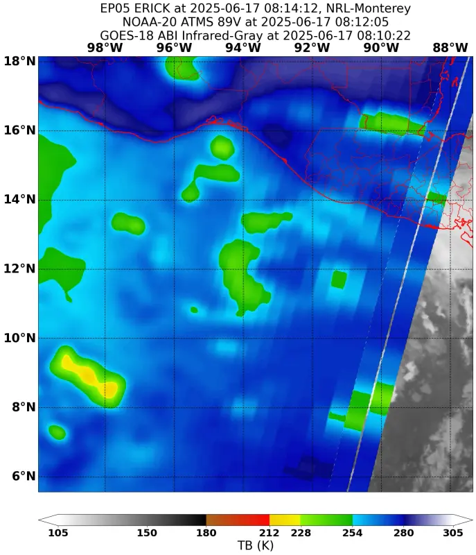
Low resolution ATMS pass but it shows a core is forming.
0 likes
RIP Kobe Bryant
-
cycloneye
- Admin
- Posts: 149464
- Age: 69
- Joined: Thu Oct 10, 2002 10:54 am
- Location: San Juan, Puerto Rico
Re: EPAC: ERICK - Tropical Storm - Discussion
Look at all the curved bandings. Not liking what I see for landfall, but hopefully, nothing like Otis,John or Patricia.

0 likes
Visit the Caribbean-Central America Weather Thread where you can find at first post web cams,radars
and observations from Caribbean basin members Click Here
and observations from Caribbean basin members Click Here
Re: EPAC: ERICK - Tropical Storm - Discussion
06z hurricane models peak intensities.
HWRF = 954 mb, 104 kt at +60h
HMON = 941 mb, 120 kt at +57h
HAFS-A = 978 mb, 89 kt at +54h
HAFS-B = 962 mb, 108 kt at +51h
HWRF = 954 mb, 104 kt at +60h
HMON = 941 mb, 120 kt at +57h
HAFS-A = 978 mb, 89 kt at +54h
HAFS-B = 962 mb, 108 kt at +51h
0 likes
-
cycloneye
- Admin
- Posts: 149464
- Age: 69
- Joined: Thu Oct 10, 2002 10:54 am
- Location: San Juan, Puerto Rico
Re: EPAC: ERICK - Tropical Storm - Discussion
BULLETIN
Tropical Storm Erick Intermediate Advisory Number 3A
NWS National Hurricane Center Miami FL EP052025
600 AM CST Tue Jun 17 2025
...ERICK EXPECTED TO BECOME A HURRICANE ON WEDNESDAY WHILE
APPROACHING THE COASTS OF OAXACA AND GUERRERO MEXICO...
SUMMARY OF 600 AM CST...1200 UTC...INFORMATION
----------------------------------------------
LOCATION...12.1N 93.8W
ABOUT 430 MI...695 KM SE OF PUNTA MALDONADO MEXICO
MAXIMUM SUSTAINED WINDS...40 MPH...65 KM/H
PRESENT MOVEMENT...WNW OR 300 DEGREES AT 12 MPH...19 KM/H
MINIMUM CENTRAL PRESSURE...1005 MB...29.68 INCHES
0 likes
Visit the Caribbean-Central America Weather Thread where you can find at first post web cams,radars
and observations from Caribbean basin members Click Here
and observations from Caribbean basin members Click Here
-
cycloneye
- Admin
- Posts: 149464
- Age: 69
- Joined: Thu Oct 10, 2002 10:54 am
- Location: San Juan, Puerto Rico
Re: EPAC: ERICK - Tropical Storm - Discussion
EP, 05, 2025061712, , BEST, 0, 121N, 939W, 40, 1003, TS
0 likes
Visit the Caribbean-Central America Weather Thread where you can find at first post web cams,radars
and observations from Caribbean basin members Click Here
and observations from Caribbean basin members Click Here
-
Sciencerocks
- Category 5
- Posts: 10186
- Age: 40
- Joined: Thu Jul 06, 2017 1:51 am

-
cycloneye
- Admin
- Posts: 149464
- Age: 69
- Joined: Thu Oct 10, 2002 10:54 am
- Location: San Juan, Puerto Rico
Re: EPAC: ERICK - Tropical Storm - Discussion
1 likes
Visit the Caribbean-Central America Weather Thread where you can find at first post web cams,radars
and observations from Caribbean basin members Click Here
and observations from Caribbean basin members Click Here
-
cycloneye
- Admin
- Posts: 149464
- Age: 69
- Joined: Thu Oct 10, 2002 10:54 am
- Location: San Juan, Puerto Rico
Re: EPAC: ERICK - Tropical Storm - Discussion
Breaking News= New peak intensity up to 95kt
BULLETIN
Tropical Storm Erick Advisory Number 4
NWS National Hurricane Center Miami FL EP052025
900 AM CST Tue Jun 17 2025
...ERICK FORECAST TO RAPIDLY INTENSIFY...
...HURRICANE WARNINGS ISSUED FOR PORTIONS OF THE OAXACA COAST...
SUMMARY OF 900 AM CST...1500 UTC...INFORMATION
----------------------------------------------
LOCATION...12.3N 94.1W
ABOUT 285 MI...460 KM SE OF PUERTO ANGEL MEXICO
ABOUT 410 MI...655 KM SE OF PUNTA MALDONADO MEXICO
MAXIMUM SUSTAINED WINDS...45 MPH...75 KM/H
PRESENT MOVEMENT...WNW OR 300 DEGREES AT 9 MPH...15 KM/H
MINIMUM CENTRAL PRESSURE...1003 MB...29.62 INCHES
WATCHES AND WARNINGS
--------------------
CHANGES WITH THIS ADVISORY:
The government of Mexico has issued a Hurricane Warning from Puerto
Angel to Punta Maldonado. A Hurricane Watch has been issued west
of Punta Maldonado to Acapulco. A Tropical Storm Warning has been
issued east of Puerto Angel to Salina Cruz.
Tropical Storm Erick Discussion Number 4
NWS National Hurricane Center Miami FL EP052025
900 AM CST Tue Jun 17 2025
Erick's structure continues to show signs of organization, with a
partial 0819 UTC AMSR2 microwave pass possibly showing the initial
development of an inner core. Subjective Dvorak estimates from
TAFB and SAB are T2.5/35 kt, and the latest objective ADT estimate
is just over 40 kt. Based on a blend of these data, the initial
intensity is raised to 40 kt.
Erick appears to have slowed down a bit and is moving
west-northwestward (300 degrees) at 8 kt. The storm is reaching
the western extent of a mid-level ridge to the north, with a
mid-/upper-level trough located over northern Mexico. These
features should cause Erick to turn northwestward later today, with
that trajectory continuing for the next 3 days. Speed-wise, the
cyclone is likely to move at its slowest (around 6 kt) this evening
but then gradually accelerate during the next several days.
Although the models are in good agreement on the general track of
Erick, the storm's parallel trajectory to the coast of Mexico will
play an important role in exactly which areas receive the most
significant wind and surge impacts. The updated NHC track forecast
has been nudged westward, and generally lies between the HCCA and
TVCE consensus aids.
The environment appears ideal for rapid strengthening. Vertical
shear is expected to be very low, with the cyclone moving over
waters of around 29 degrees Celsius and within a moist
mid-level environment of around 80 percent relative humidity.
As a result of these conditions, Rapid intensification (RI) indices
are rather high, particular for the 36- and 48-hour periods. The
NHC intensity forecast explicitly shows RI occurring while Erick
approaches the coast of southern Mexico, with a 48-hour intensity
just below major hurricane strength. Despite this increase in the
forecast intensity, there are still a few models (including the
normally skillful HCCA aid) that show Erick reaching major
hurricane strength, and additional upward adjustments in the
forecast could be required later today.
KEY MESSAGES:
1. Erick is expected to rapidly intensify before reaching the coast
of southern Mexico on Thursday, and a hurricane warning is now in
effect for portions of the coast of Oaxaca. A hurricane watch is
in effect for portions of the Guerrero coast.
2. Erick will produce heavy rainfall across portions of Central
America and Southwest Mexico through this week. Life threatening
flooding and mudslides are possible, especially in areas of steep
terrain.
3. A dangerous storm surge is expected to produce coastal flooding
near and to the east of where the center crosses the coast, in
areas of onshore winds.
FORECAST POSITIONS AND MAX WINDS
INIT 17/1500Z 12.3N 94.1W 40 KT 45 MPH
12H 18/0000Z 12.8N 94.9W 55 KT 65 MPH
24H 18/1200Z 13.6N 96.0W 70 KT 80 MPH
36H 19/0000Z 14.7N 97.2W 90 KT 105 MPH
48H 19/1200Z 16.0N 98.5W 95 KT 110 MPH
60H 20/0000Z 17.5N 100.2W 60 KT 70 MPH...INLAND
72H 20/1200Z 18.8N 102.1W 30 KT 35 MPH...POST-TROP/REMNT LOW
96H 21/1200Z...DISSIPATED
$$
Forecaster Berg/Mora
2 likes
Visit the Caribbean-Central America Weather Thread where you can find at first post web cams,radars
and observations from Caribbean basin members Click Here
and observations from Caribbean basin members Click Here
Re: EPAC: ERICK - Tropical Storm - Discussion: Breaking news= New peak intensity up to 95kt
12 UTC rapid intensification indices give a 37% (AI-RI) and 35% (SHIPS consensus) chance of 65kt/72hr intensification which would mean at least 105 kt before landfall. SHIPS even has 72% chance of 55/48 -> 95 kt within 48 hours. On top of that Erick already looks better now than most models said would be the case. I'm afraid we're looking at another potential MH landfall in Mexico.
4 likes
Who is online
Users browsing this forum: No registered users and 17 guests