https://x.com/cyclonicwx/status/1934987176493654457
EPAC: ERICK - Post-Tropical - Discussion
Moderator: S2k Moderators
-
DorkyMcDorkface

- Category 5

- Posts: 1012
- Age: 28
- Joined: Mon Sep 30, 2019 1:32 pm
- Location: Mid-Atlantic
Re: EPAC: ERICK - Tropical Storm - Discussion: Breaking news= New peak intensity up to 95kt
0 likes
Please note the thoughts expressed by this account are solely those of the user and are from a hobbyist perspective. For more comprehensive analysis, consult an actual professional meteorologist or meteorological agency.
Floyd 1999 | Isabel 2003 | Hanna 2008 | Irene 2011 | Sandy 2012 | Isaias 2020
-
cycloneye

- Admin

- Posts: 149465
- Age: 69
- Joined: Thu Oct 10, 2002 10:54 am
- Location: San Juan, Puerto Rico
Re: EPAC: ERICK - Tropical Storm - Discussion: Breaking news= New peak intensity up to 95kt
Erick is about to reach one of the warmest areas of the planet in terms of sst's. 

4 likes
Visit the Caribbean-Central America Weather Thread where you can find at first post web cams,radars
and observations from Caribbean basin members Click Here
and observations from Caribbean basin members Click Here
-
Kingarabian

- S2K Supporter

- Posts: 16364
- Joined: Sat Aug 08, 2009 3:06 am
- Location: Honolulu, Hawaii
Re: EPAC: ERICK - Tropical Storm - Discussion
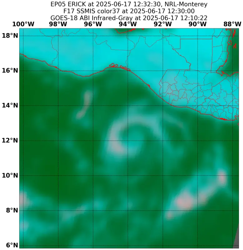
Latest SSMIS pass shows the core developing at a quick pace. Great overall structure. Better than the first 4 slops we've seen so far.
1 likes
RIP Kobe Bryant
-
Category5Kaiju

- Category 5
- Posts: 4333
- Joined: Thu Dec 24, 2020 12:45 pm
- Location: Seattle and Phoenix
Re: EPAC: ERICK - Tropical Storm - Discussion
So are there any large towns or cities in the way of Erick?
0 likes
Unless explicitly stated, all info in my posts is based on my own opinions and observations. Tropical storms and hurricanes can be extremely dangerous. Refer to an accredited weather research agency or meteorologist if you need to make serious decisions regarding an approaching storm.
-
cycloneye
- Admin
- Posts: 149465
- Age: 69
- Joined: Thu Oct 10, 2002 10:54 am
- Location: San Juan, Puerto Rico
Re: EPAC: ERICK - Tropical Storm - Discussion
Category5Kaiju wrote:So are there any large towns or cities in the way of Erick?
Hopefully, Acapulco gets spared the worse, but it will be very close.
1 likes
Visit the Caribbean-Central America Weather Thread where you can find at first post web cams,radars
and observations from Caribbean basin members Click Here
and observations from Caribbean basin members Click Here
-
DorkyMcDorkface
- Category 5
- Posts: 1012
- Age: 28
- Joined: Mon Sep 30, 2019 1:32 pm
- Location: Mid-Atlantic
Re: EPAC: ERICK - Tropical Storm - Discussion
Category5Kaiju wrote:So are there any large towns or cities in the way of Erick?
I believe Acapulco is the largest (pop. >650,000). Same general area affected by Otis
0 likes
Please note the thoughts expressed by this account are solely those of the user and are from a hobbyist perspective. For more comprehensive analysis, consult an actual professional meteorologist or meteorological agency.
Floyd 1999 | Isabel 2003 | Hanna 2008 | Irene 2011 | Sandy 2012 | Isaias 2020
-
cycloneye
- Admin
- Posts: 149465
- Age: 69
- Joined: Thu Oct 10, 2002 10:54 am
- Location: San Juan, Puerto Rico
Re: EPAC: ERICK - Tropical Storm - Discussion
Zoomed to the building inner core.

2 likes
Visit the Caribbean-Central America Weather Thread where you can find at first post web cams,radars
and observations from Caribbean basin members Click Here
and observations from Caribbean basin members Click Here
-
Yellow Evan

- Professional-Met

- Posts: 16240
- Age: 27
- Joined: Fri Jul 15, 2011 12:48 pm
- Location: Henderson, Nevada/Honolulu, HI
- Contact:
Re: EPAC: ERICK - Tropical Storm - Discussion
Convection is wrapping around but overall structure is very bandy so far - need more centralized convection to generate a steeper pressure gradient and a tighter RMW
3 likes
-
cycloneye
- Admin
- Posts: 149465
- Age: 69
- Joined: Thu Oct 10, 2002 10:54 am
- Location: San Juan, Puerto Rico
Re: EPAC: ERICK - Tropical Storm - Discussion
0 likes
Visit the Caribbean-Central America Weather Thread where you can find at first post web cams,radars
and observations from Caribbean basin members Click Here
and observations from Caribbean basin members Click Here
-
cycloneye
- Admin
- Posts: 149465
- Age: 69
- Joined: Thu Oct 10, 2002 10:54 am
- Location: San Juan, Puerto Rico
Re: EPAC: ERICK - Tropical Storm - Discussion
Up to 50 mph.
BULLETIN
Tropical Storm Erick Intermediate Advisory Number 4A
NWS National Hurricane Center Miami FL EP052025
1200 PM CST Tue Jun 17 2025
...ERICK STRENGTHENING...
SUMMARY OF 1200 PM CST...1800 UTC...INFORMATION
-----------------------------------------------
LOCATION...12.6N 94.1W
ABOUT 265 MI...430 KM SE OF PUERTO ANGEL MEXICO
ABOUT 395 MI...635 KM SE OF PUNTA MALDONADO MEXICO
MAXIMUM SUSTAINED WINDS...50 MPH...85 KM/H
PRESENT MOVEMENT...WNW OR 300 DEGREES AT 9 MPH...15 KM/H
MINIMUM CENTRAL PRESSURE...1001 MB...29.56 INCHES
2 likes
Visit the Caribbean-Central America Weather Thread where you can find at first post web cams,radars
and observations from Caribbean basin members Click Here
and observations from Caribbean basin members Click Here
-
cheezyWXguy

- Category 5
- Posts: 6282
- Joined: Mon Feb 13, 2006 12:29 am
- Location: Dallas, TX
Re: EPAC: ERICK - Tropical Storm - Discussion
Yellow Evan wrote:Convection is wrapping around but overall structure is very bandy so far - need more centralized convection to generate a steeper pressure gradient and a tighter RMW
Thinking dmax tonight will help with that
0 likes
-
cycloneye
- Admin
- Posts: 149465
- Age: 69
- Joined: Thu Oct 10, 2002 10:54 am
- Location: San Juan, Puerto Rico
Re: EPAC: ERICK - Tropical Storm - Discussion
Meso floater.

4 likes
Visit the Caribbean-Central America Weather Thread where you can find at first post web cams,radars
and observations from Caribbean basin members Click Here
and observations from Caribbean basin members Click Here
-
cycloneye
- Admin
- Posts: 149465
- Age: 69
- Joined: Thu Oct 10, 2002 10:54 am
- Location: San Juan, Puerto Rico
Re: EPAC: ERICK - Tropical Storm - Discussion
Ramping up now.
. 05E (ERICK)
B. 17/1800Z
C. 12.7N
D. 94.1W
E. THREE/GOES-E
F. T3.5/3.5
G. IR/EIR/VIS/SSMIS/MHS
H. REMARKS...12/10 BANDING YIELDS A DT OF 4.0. THE MET IS 3.0 BASED
ON A RAPID DEVELOPMENT TREND OVER THE PAST 24 HOURS. THE PT IS 3.5. THE
SIX HOUR AVERAGE DT OF 3.8 DOES NOT JUSTIFY BREAKING CONSTRAINTS AT THIS
TIME. THE FT IS BASED ON CONSTRAINTS LIMITING THE CHANGE IN T-NUMBER TO
1.0 OVER SIX HOURS.
I. ADDL POSITIONS
17/1214Z 12.5N 94.0W SSMIS
17/1558Z 12.6N 94.0W MHS
...COVERDALE
0 likes
Visit the Caribbean-Central America Weather Thread where you can find at first post web cams,radars
and observations from Caribbean basin members Click Here
and observations from Caribbean basin members Click Here
-
ColdMiser123

- Professional-Met
- Posts: 905
- Age: 29
- Joined: Mon Sep 26, 2016 3:26 pm
- Location: Northeast US
Re: EPAC: ERICK - Tropical Storm - Discussion
The steering pattern for Erick consists of SE/SSE low-level flow, & more E upper-level flow. The stronger & taller Erick is, the more influenced by the upper-level steering flow it will be, & the more likely Erick will take a more westward track.

0 likes
B.S., M.S., Meteorology & Atmospheric Science
-
Kingarabian
- S2K Supporter
- Posts: 16364
- Joined: Sat Aug 08, 2009 3:06 am
- Location: Honolulu, Hawaii
Re: EPAC: ERICK - Tropical Storm - Discussion
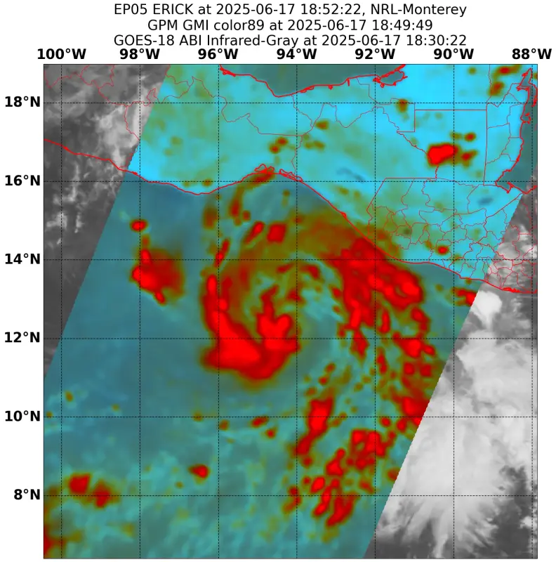
Latest GMI pass showing the core tightening up:
Warm spot on visible.
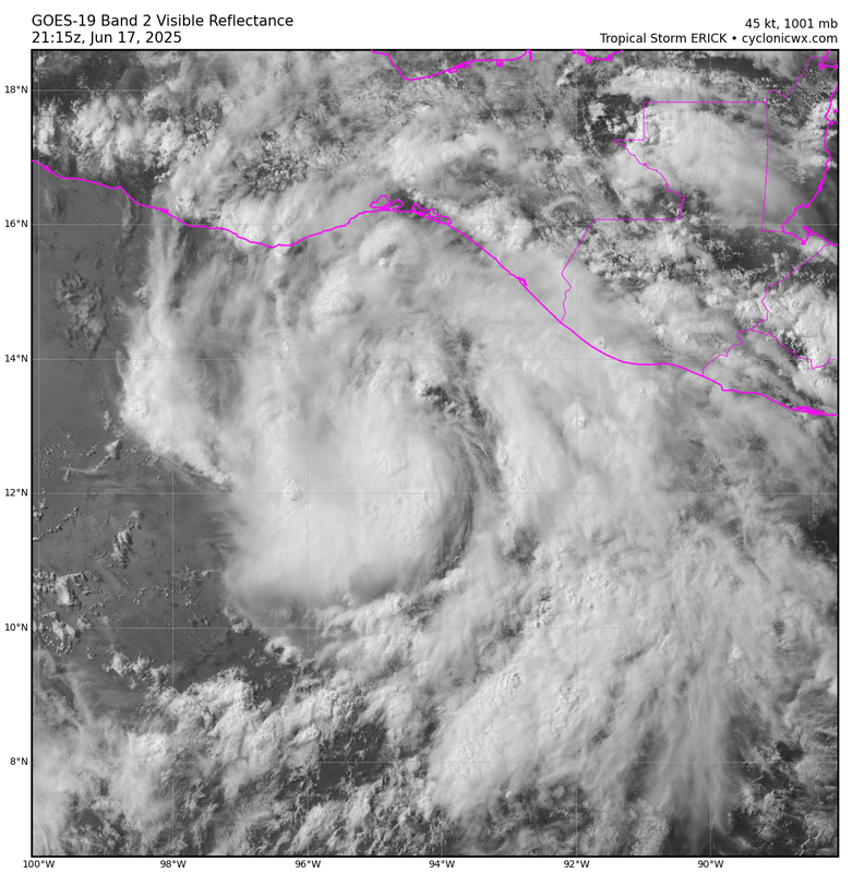
Borderline hurricane
Warm spot on visible.
Borderline hurricane
3 likes
RIP Kobe Bryant
-
Hurricane2022

- Category 5
- Posts: 2037
- Joined: Tue Aug 23, 2022 11:38 pm
- Location: Araçatuba, Brazil
Re: EPAC: ERICK - Tropical Storm - Discussion
Kingarabian wrote:Latest GMI pass showing the core tightening up:
https://i.postimg.cc/LsfqZhqN/image.webp
Warm spot on visible.
https://i.postimg.cc/XYZJ5XZt/goes19-05-E-vis-202506172115.png
Borderline hurricane
https://x.com/SouthFLwx04/status/1935077093974417863
1 likes
Sorry for the bad English sometimes...!
For reliable and detailed information for any meteorological phenomenon, please consult the National Hurricane Center, Joint Typhoon Warning Center , or your local Meteo Center.
--------
ECCE OMNIA NOVA FACIAM (Ap 21,5).
For reliable and detailed information for any meteorological phenomenon, please consult the National Hurricane Center, Joint Typhoon Warning Center , or your local Meteo Center.
--------
ECCE OMNIA NOVA FACIAM (Ap 21,5).
-
cycloneye
- Admin
- Posts: 149465
- Age: 69
- Joined: Thu Oct 10, 2002 10:54 am
- Location: San Juan, Puerto Rico
Re: EPAC: ERICK - Tropical Storm - Discussion
For the archieve of the thread the delayed posting of advisory.
BULLETIN
Tropical Storm Erick Advisory Number 5
NWS National Hurricane Center Miami FL EP052025
300 PM CST Tue Jun 17 2025
...ERICK FORECAST TO BRING HURRICANE CONDITIONS TO PORTIONS OF
SOUTHERN MEXICO WEDNESDAY NIGHT AND THURSDAY...
...LIFE-THREATENING FLASH FLOODS LIKELY...
SUMMARY OF 300 PM CST...2100 UTC...INFORMATION
----------------------------------------------
LOCATION...12.9N 94.4W
ABOUT 240 MI...385 KM SE OF PUERTO ANGEL MEXICO
ABOUT 365 MI...590 KM SE OF PUNTA MALDONADO MEXICO
MAXIMUM SUSTAINED WINDS...50 MPH...85 KM/H
PRESENT MOVEMENT...NW OR 310 DEGREES AT 7 MPH...11 KM/H
MINIMUM CENTRAL PRESSURE...1001 MB...29.56 INCHES
Tropical Storm Erick Discussion Number 5
NWS National Hurricane Center Miami FL EP052025
300 PM CST Tue Jun 17 2025
Erick has continued to become better organized in visible satellite
imagery, with an extended cloud band curling one revolution around
the center. However, there is also some evidence of a dry slot
filtering into the circulation from the southeast, and possibly as
a result, infrared cloud top temperatures in the band are not as
cold as they could be. Subjective Dvorak classifications have
risen to T3.0/45 kt from TAFB and T3.5/55 kt from SAB, but the
initial intensity is held conservatively at 45 kt since objective
numbers are closest to the TAFB estimate.
The center appears to have turned northwestward (310 degrees) and
is moving around 6 kt. A mid-level ridge to the north of the
cyclone, and a mid-/upper-level trough over northern Mexico, should
keep Erick on a generally northwestward trajectory for the next
couple of days, with a gradual increase in forward speed. The NHC
forecast track lies close to the HCCA and TVCE consensus aids, and
it a little east of the previous prediction. Because of the
oblique angle of Erick's track relative to the coast, it is
impossible to know exactly where the strongest winds might occur,
but it is becoming increasingly likely that they will occur in the
area of western Oaxaca or eastern Guerrero states.
Despite the current convective pattern, the environment of low wind
shear, high mid-level moisture, and warm sea surface temperatures
should still support rapid strengthening. Erick also has the
structure to enable rapid intensification, and it may only take
mixing out some of the dry air for that process to begin. Rapid
intensification (RI) indices fell a little on this forecast cycle,
mainly due to a negative contribution from the influx of drier
boundary layer air. However, assuming this dry air can mix out,
the NHC intensity forecast continues to be near the high end of the
guidance (closest to HCCA and HMON), and still shows Erick near or
at major hurricane strength when it approaches the coast of
southern Mexico.
KEY MESSAGES:
1. Erick is expected to rapidly intensify before reaching the coast
of southern Mexico on Thursday, and a hurricane warning is in effect
for portions of the coast of Oaxaca. A hurricane watch is in effect
for portions of the Guerrero coast.
2. Erick will produce heavy rainfall across portions of Central
America and Southwest Mexico through this week. Life-threatening
flooding and mudslides are possible, especially in areas of steep
terrain.
3. A dangerous storm surge is expected to produce coastal flooding
near and to the east of where the center crosses the coast, in
areas of onshore winds.
FORECAST POSITIONS AND MAX WINDS
INIT 17/2100Z 12.9N 94.4W 45 KT 50 MPH
12H 18/0600Z 13.3N 95.2W 60 KT 70 MPH
24H 18/1800Z 14.2N 96.4W 80 KT 90 MPH
36H 19/0600Z 15.4N 97.5W 95 KT 110 MPH
48H 19/1800Z 16.9N 99.0W 80 KT 90 MPH...INLAND
60H 20/0600Z 18.3N 100.8W 35 KT 40 MPH...INLAND
72H 20/1800Z...DISSIPATED
$$
Forecaster Berg
0 likes
Visit the Caribbean-Central America Weather Thread where you can find at first post web cams,radars
and observations from Caribbean basin members Click Here
and observations from Caribbean basin members Click Here
-
Sciencerocks
- Category 5
- Posts: 10186
- Age: 40
- Joined: Thu Jul 06, 2017 1:51 am

-
cycloneye
- Admin
- Posts: 149465
- Age: 69
- Joined: Thu Oct 10, 2002 10:54 am
- Location: San Juan, Puerto Rico
Re: EPAC: ERICK - Tropical Storm - Discussion
BULLETIN
Tropical Storm Erick Intermediate Advisory Number 5A
NWS National Hurricane Center Miami FL EP052025
600 PM CST Tue Jun 17 2025
...ERICK FORECAST TO BRING HURRICANE CONDITIONS TO PORTIONS OF
SOUTHERN MEXICO WEDNESDAY NIGHT AND THURSDAY...
...LIFE-THREATENING FLASH FLOODS LIKELY...
SUMMARY OF 600 PM CST...0000 UTC...INFORMATION
----------------------------------------------
LOCATION...12.9N 94.6W
ABOUT 230 MI...370 KM SSE OF PUERTO ANGEL MEXICO
ABOUT 355 MI...570 KM SE OF PUNTA MALDONADO MEXICO
MAXIMUM SUSTAINED WINDS...50 MPH...85 KM/H
PRESENT MOVEMENT...NW OR 310 DEGREES AT 7 MPH...11 KM/H
MINIMUM CENTRAL PRESSURE...1001 MB...29.56 INCHES
0 likes
Visit the Caribbean-Central America Weather Thread where you can find at first post web cams,radars
and observations from Caribbean basin members Click Here
and observations from Caribbean basin members Click Here


Re: EPAC: ERICK - Tropical Storm - Discussion
Looks like all strengthening from here on out. First major?
0 likes
The above post and any post by Ntxw is NOT an official forecast and should not be used as such. It is just the opinion of the poster and may or may not be backed by sound meteorological data. It is NOT endorsed by any professional institution including Storm2k. For official information, please refer to NWS products.
Help support Storm2K!

Who is online
Users browsing this forum: No registered users and 7 guests