2025 ENSO Updates
Moderator: S2k Moderators
Forum rules

The posts in this forum are NOT official forecasts and should not be used as such. They are just the opinion of the poster and may or may not be backed by sound meteorological data. They are NOT endorsed by any professional institution or STORM2K. For official information, please refer to products from the National Hurricane Center and National Weather Service.
Re: 2025 ENSO Updates
Why was 2024 ever even called a La Nina by some private meteorologists, particularly after the fact when no new trimonthlies were going to reach? Because there were some Nina like conditions? It does not look like this event will qualify even when the climo inevitably gets updated. I just don’t see a -.2C becoming a -0.5C reading in the next 15 years unless they change away from ERSST v5 or stop classifying events purely on the basis of absolute ONI. 2024 was a cool neutral year that briefly went into La Nina territory. An unofficial La Nina if you will, but not a full one. Strength is based on 3 consecutive trimonthlies, so there is a point to be made there. However, you do need 5 trimonthlies for a weak phase to even qualify as an ENSO event in the first place.
2 likes
All posts by Dean_175 are NOT official forecasts and should not be used as such. They are just the opinion of the poster and may or may not be backed by sound meteorological data. They are NOT endorsed by any professional institution or storm2k.org. For official information, please refer to the NHC and NWS products.
Re: 2025 ENSO Updates
Dean_175 wrote:Why was 2024 ever even called a La Nina by some private meteorologists, particularly after the fact when no new trimonthlies were going to reach? Because there were some Nina like conditions? It does not look like this event will qualify even when the climo inevitably gets updated. I just don’t see a -.2C becoming a -0.5C reading in the next 15 years unless they change away from ERSST v5 or stop classifying events purely on the basis of absolute ONI. 2024 was a cool neutral year that briefly went into La Nina territory. An unofficial La Nina if you will, but not a full one. Strength is based on 3 consecutive trimonthlies, so there is a point to be made there. However, you do need 5 trimonthlies for a weak phase to even qualify as an ENSO event in the first place.
Officially, it wasn’t La Nina. You may realize this but for those not aware, it was the equivalent of a low end moderate La Niña peak (-1.12 for DJF) per RONI:
https://www.cpc.ncep.noaa.gov/data/indi ... .ascii.txt
I think that the ASO 2024 RONI of -0.75, which was near the “sweet spot” historically for the most dangerous seasons to the NE Caribbean, Bahamas, FL, SE US, and the E GOM on an ONI basis, can help explain why the 2024 season was so bad for these areas despite an ASO ONI of a mere -0.21 (barely cold neutral). Thus I continue to feel that RONI tends to be more telling than ONI regarding the hurricane season.
If I’m recalling correctly, US Tropics last year posted some maps showing weak La Niña during ASO to average more dangerous to those areas than the average for cold neutral or moderate to strong La Niña based on many decades of data. Of course these are just averages and there’s still plenty of variance in individual seasons. Regardless, the fact that I think we’re likely headed for an ASO 2025 RONI within weak La Niña boundaries isn’t exactly comforting to me. But the good news fwiw per the last few Euro seasonals is that those areas on the whole won’t be hit nearly as hard as last year’s terrible season.
As this shows, RONI trimonthlies have maintained equivalent weak La Niña levels with the last one at -0.53 (MAM). Interestingly, RONI less ONI was -0.44 in MAM. This has risen from the -0.64 bottom of about a year ago. Will this trend of them getting back closer together continue? Nobody knows.
I’m thinking that AMJ will likely drop back down slightly…perhaps to ~-0.6 based on underlying OISST but there’s uncertainty due to the recent narrowing of RONI minus ONI. It will be interesting to see what happens.
2 likes
Personal Forecast Disclaimer:
The posts in this forum are NOT official forecasts and should not be used as such. They are just the opinion of the poster and may or may not be backed by sound meteorological data. They are NOT endorsed by any professional institution or storm2k.org. For official information, please refer to the NHC and NWS products.
The posts in this forum are NOT official forecasts and should not be used as such. They are just the opinion of the poster and may or may not be backed by sound meteorological data. They are NOT endorsed by any professional institution or storm2k.org. For official information, please refer to the NHC and NWS products.
-
USTropics
- Professional-Met

- Posts: 2739
- Joined: Sun Aug 12, 2007 3:45 am
- Location: Florida State University
Re: 2025 ENSO Updates
LarryWx wrote:Dean_175 wrote:Why was 2024 ever even called a La Nina by some private meteorologists, particularly after the fact when no new trimonthlies were going to reach? Because there were some Nina like conditions? It does not look like this event will qualify even when the climo inevitably gets updated. I just don’t see a -.2C becoming a -0.5C reading in the next 15 years unless they change away from ERSST v5 or stop classifying events purely on the basis of absolute ONI. 2024 was a cool neutral year that briefly went into La Nina territory. An unofficial La Nina if you will, but not a full one. Strength is based on 3 consecutive trimonthlies, so there is a point to be made there. However, you do need 5 trimonthlies for a weak phase to even qualify as an ENSO event in the first place.
Officially, it wasn’t La Nina. You may realize this but for those not aware, it was the equivalent of a low end moderate La Niña peak (-1.12 for DJF) per RONI:
https://www.cpc.ncep.noaa.gov/data/indi ... .ascii.txt
I think that the ASO 2024 RONI of -0.75, which was near the “sweet spot” historically for the most dangerous seasons to the NE Caribbean, Bahamas, FL, SE US, and the E GOM on an ONI basis, can help explain why the 2024 season was so bad for these areas despite an ASO ONI of a mere -0.21 (barely cold neutral). Thus I continue to feel that RONI tends to be more telling than ONI regarding the hurricane season.
If I’m recalling correctly, US Tropics last year posted some maps showing weak La Niña during ASO to average more dangerous to those areas than the average for cold neutral or moderate to strong La Niña based on many decades of data. Of course these are just averages and there’s still plenty of variance in individual seasons. Regardless, the fact that I think we’re likely headed for an ASO 2025 RONI within weak La Niña boundaries isn’t exactly comforting to me. But the good news fwiw per the last few Euro seasonals is that those areas on the whole won’t be hit nearly as hard as last year’s terrible season.
As this shows, RONI trimonthlies have maintained equivalent weak La Niña levels with the last one at -0.53 (MAM). Interestingly, RONI less ONI was -0.44 in MAM. This has risen from the -0.64 bottom of about a year ago. Will this trend of them getting back closer together continue? Nobody knows.
I’m thinking that AMJ will likely drop back down slightly…perhaps to ~-0.6 based on underlying OISST but there’s uncertainty due to the recent narrowing of RONI minus ONI. It will be interesting to see what happens.
There are some really good comments from Nathaniel Johnson (he is one of the meteorologists that writes the ENSO blog) on RONI vs ONI. Here were some of his replies to comments:
It's true that ENSO, as monitored by the Nino-3.4 sea surface temperatures, and the Southern Oscillation Index do not track each other perfectly, but I am not sure what you mean by El Nino and the Southern Oscillation have been out of phase in recent years. Overall, when we average over three-month seasons, the Southern Oscillation Index (SOI) generally has tracked the Oceanic Nino Index (ONI) in the way we expect for El Nino and La Nina - compare the SOI table with the ONI table.
The effect of ocean warming on our traditional indices is an important consideration, and that is why some have advocated for a relative Nino-3.4 index over the traditional index that carries some of that global warming influence unrelated to ENSO. We expect the relative Nino-3.4 index to maintain a closer relationship with the SOI. So I can understand your point that we didn't see as strong a relationship between the SOI and traditional Nino-3.4 index in the most recent El Nino (2023/24), but we wouldn't expect to separate the SOI from ENSO because ENSO is a coupled phenomenon that requires interaction between the tropical atmosphere and ocean. The better solution may be use alternative indices like the relative Nino-3.4 index that better capture this interaction.
Your suggestion about forecasting El Nino/La Nina and the Southern Oscillation separately is interesting. As I mentioned above, we won't be able to separate the Southern Oscillation from ENSO (one of the requirements for El Nino/La Nina is that the tropical atmosphere is consistent with El Nino/La Nina conditions, and that will be reflected in the Southern Oscillation), but we still could consider what it would take to forecast the part of the Southern Oscillation that is independent of ENSO. Because the SOI is an atmospheric index, it bounces up and down a lot more than the Nino-3.4 region sea surface temperatures. So, if we subtracted out the part of the SOI that is tied to the ocean surface temperatures (again, probably using the relative Nino-3.4 index), then I suspect that what's left of the SOI is mostly predictable on weather and subseasonal timescales. So, it may be useful on those shorter timescales, but I suspect that the seasonal predictability of the ENSO-independent SOI would be quite small.
I would need more context about what La Nina-like characteristics you are referring to, but I will raise a couple of general possibilities. First, some of the effects of ENSO on the Far East tend to be delayed, as they are relayed through the more delayed warming or cooling of the Indian Ocean. So, we summer impacts of ENSO on the Far East may be a delayed impact of the previous winter's ENSO (the so-called Indian Ocean capacitor effect). Another possibility, as we have raised repeatedly in the blog, is that the relative Nino 3.4 index is consistent with weak La Nina conditions even though the traditional Nino-3.4 index indicates neutral ENSO conditions. So, the atmosphere may be reflecting the fact that the tropical east-central Pacific is cool relative to the rest of the tropics.
I think the reason is more related to the latter - the shift of the tropical convection pattern during La Nina forces a negative PNA-like pattern that leads to a retraction of the North Pacific jet stream. These responses are never as simple as the most basic theory, and there are reinforcing feedbacks from transient eddy fluxes. So, I don't think I could rule out some role for the changes in baroclinicity associated with the change in the north-south temperature gradient.
As to why we haven't been using RONI sooner, I just have to leave that to the community at large. Thanks for your question!
1 likes
-
Kingarabian

- S2K Supporter

- Posts: 16377
- Joined: Sat Aug 08, 2009 3:06 am
- Location: Honolulu, Hawaii
Re: 2025 ENSO Updates
BTW most recent CFS runs have switched to LA Nina by the end of the year. Big flip compared to what it was showing during the spring months.
3 likes
RIP Kobe Bryant
-
cycloneye

- Admin

- Posts: 149696
- Age: 69
- Joined: Thu Oct 10, 2002 10:54 am
- Location: San Juan, Puerto Rico
Re: 2025 ENSO Updates: CPC Weekly Update of 6/23/25=Niño 3.4 up to +0.2C
CPC in the weekly update has niño 3.4 up to +0.2C.
https://www.cpc.ncep.noaa.gov/products/ ... ts-web.pdf

https://www.cpc.ncep.noaa.gov/products/ ... ts-web.pdf
2 likes
Visit the Caribbean-Central America Weather Thread where you can find at first post web cams,radars
and observations from Caribbean basin members Click Here
and observations from Caribbean basin members Click Here
Re: 2025 ENSO Updates: CPC Weekly Update of 6/23/25=Niño 3.4 up to +0.2C
cycloneye wrote:CPC in the weekly update has niño 3.4 up to +0.2C.
https://www.cpc.ncep.noaa.gov/products/ ... ts-web.pdf
https://i.imgur.com/cNcccF4.jpeg
The RONI equivalent for 3.4 is probably in the general vicinity of -0.2C.
1 likes
Personal Forecast Disclaimer:
The posts in this forum are NOT official forecasts and should not be used as such. They are just the opinion of the poster and may or may not be backed by sound meteorological data. They are NOT endorsed by any professional institution or storm2k.org. For official information, please refer to the NHC and NWS products.
The posts in this forum are NOT official forecasts and should not be used as such. They are just the opinion of the poster and may or may not be backed by sound meteorological data. They are NOT endorsed by any professional institution or storm2k.org. For official information, please refer to the NHC and NWS products.
-
cycloneye
- Admin
- Posts: 149696
- Age: 69
- Joined: Thu Oct 10, 2002 10:54 am
- Location: San Juan, Puerto Rico
Re: 2025 ENSO Updates
0 likes
Visit the Caribbean-Central America Weather Thread where you can find at first post web cams,radars
and observations from Caribbean basin members Click Here
and observations from Caribbean basin members Click Here
-
Kingarabian
- S2K Supporter
- Posts: 16377
- Joined: Sat Aug 08, 2009 3:06 am
- Location: Honolulu, Hawaii
Re: 2025 ENSO Updates
Strong IO WWB and a stout Pacific trade burst.
Good chance ENSO flips negative here for the remainder of the year. Well see since the -VP200 pattern over the Pacific has been anything but -ENSO.
Good chance ENSO flips negative here for the remainder of the year. Well see since the -VP200 pattern over the Pacific has been anything but -ENSO.
1 likes
RIP Kobe Bryant
-
WeatherBoy2000
- Category 1

- Posts: 463
- Joined: Mon Apr 10, 2023 9:29 am
Re: 2025 ENSO Updates
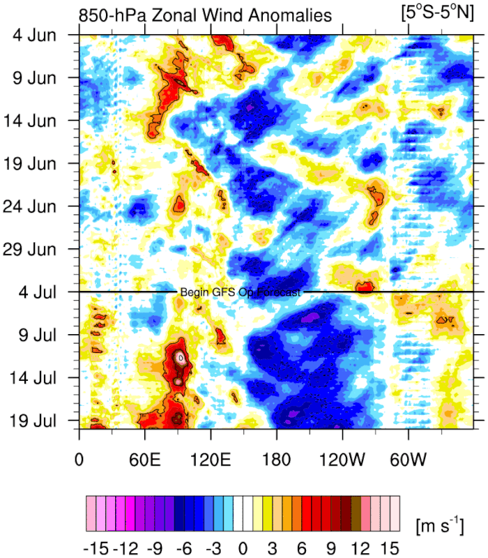
Kingarabian wrote:Strong IO WWB and a stout Pacific trade burst.
https://i.postimg.cc/L8WRCjkH/u-anom-30-5-S-5-N.gif
Good chance ENSO flips negative here for the remainder of the year. Well see since the -VP200 pattern over the Pacific has been anything but -ENSO.
https://x.com/WxTca/status/1941915107405029537
The pdo also seems to be heading in a further negative direction, although, this is more down to the waters off Japan getting exceedingly warm than due to the waters off North America getting any cooler.
1 likes
Re: 2025 ENSO Updates
WeatherBoy2000 wrote:Kingarabian wrote:Strong IO WWB and a stout Pacific trade burst.
https://i.postimg.cc/L8WRCjkH/u-anom-30-5-S-5-N.gif
Good chance ENSO flips negative here for the remainder of the year. Well see since the -VP200 pattern over the Pacific has been anything but -ENSO.
https://x.com/WxTca/status/1941915107405029537
The pdo also seems to be heading in a further negative direction, although, this is more down to the waters off Japan getting exceedingly warm than due to the waters off North America getting any cooler.
The WCS, which has daily PDOs on most days, had the 7/1/25 PDO down to -3.07. That is the lowest WCS daily I’ve seen since starting to follow it a couple of years ago. That corresponds to a NOAA daily PDO way down almost to -4!
My guess based on the past is that the daily PDO has pretty much bottomed.
0 likes
Personal Forecast Disclaimer:
The posts in this forum are NOT official forecasts and should not be used as such. They are just the opinion of the poster and may or may not be backed by sound meteorological data. They are NOT endorsed by any professional institution or storm2k.org. For official information, please refer to the NHC and NWS products.
The posts in this forum are NOT official forecasts and should not be used as such. They are just the opinion of the poster and may or may not be backed by sound meteorological data. They are NOT endorsed by any professional institution or storm2k.org. For official information, please refer to the NHC and NWS products.
-
cycloneye
- Admin
- Posts: 149696
- Age: 69
- Joined: Thu Oct 10, 2002 10:54 am
- Location: San Juan, Puerto Rico
Re: 2025 ENSO Updates
CPC weekly update has niño 3.4 at dead neutral at 0.0C.
https://www.cpc.ncep.noaa.gov/products/ ... ts-web.pdf

https://www.cpc.ncep.noaa.gov/products/ ... ts-web.pdf
0 likes
Visit the Caribbean-Central America Weather Thread where you can find at first post web cams,radars
and observations from Caribbean basin members Click Here
and observations from Caribbean basin members Click Here
-
Yellow Evan

- Professional-Met
- Posts: 16257
- Age: 27
- Joined: Fri Jul 15, 2011 12:48 pm
- Location: Henderson, Nevada/Honolulu, HI
- Contact:
Re: 2025 ENSO Updates
No clear reasons why the PDO has tanked so hard. Reemergence of the mixed layer in the fall probably means that the recent of magnitude of -PDO is unlikely to sustain past the summer but unless ENSO can take a more EP focused look (like last year), I have increasing doubts on a return of +PDO in the near future (which I had raised as a possibility earlier in the year).
0 likes
-
cycloneye
- Admin
- Posts: 149696
- Age: 69
- Joined: Thu Oct 10, 2002 10:54 am
- Location: San Juan, Puerto Rico
Re: 2025 ENSO Updates
2 likes
Visit the Caribbean-Central America Weather Thread where you can find at first post web cams,radars
and observations from Caribbean basin members Click Here
and observations from Caribbean basin members Click Here
-
cycloneye
- Admin
- Posts: 149696
- Age: 69
- Joined: Thu Oct 10, 2002 10:54 am
- Location: San Juan, Puerto Rico
Re: 2025 ENSO Updates
Breaking News
The July NMME is out and has La Niña for the Fall and Winter.
https://x.com/webberweather/status/1942356536434515994
The July NMME is out and has La Niña for the Fall and Winter.
https://x.com/webberweather/status/1942356536434515994
2 likes
Visit the Caribbean-Central America Weather Thread where you can find at first post web cams,radars
and observations from Caribbean basin members Click Here
and observations from Caribbean basin members Click Here
-
Yellow Evan
- Professional-Met
- Posts: 16257
- Age: 27
- Joined: Fri Jul 15, 2011 12:48 pm
- Location: Henderson, Nevada/Honolulu, HI
- Contact:
Re: 2025 ENSO Updates: July NMME with La Niña for Fall and Winter
I can’t remember if 200 mbar wind was a factor in MEI, but that has not resembled a La Niña the last month. 850 mbar and OLR paint a somewhat different picture but still surprised to see MEI plummet.
0 likes
-
Kingarabian
- S2K Supporter
- Posts: 16377
- Joined: Sat Aug 08, 2009 3:06 am
- Location: Honolulu, Hawaii
Re: 2025 ENSO Updates: July NMME with La Niña for Fall and Winter
Waters east of Japan are on fire.
1 likes
RIP Kobe Bryant


Re: 2025 ENSO Updates
The waters off Japan are hotter the usual for this time of year with temps from 24c-28c. It maybe a La Nina later in the year but I can see it been a more of a warm neutral year with both the Pacific and Atlantic been hot.

0 likes
-
cycloneye
- Admin
- Posts: 149696
- Age: 69
- Joined: Thu Oct 10, 2002 10:54 am
- Location: San Juan, Puerto Rico
Re: 2025 ENSO Updates
CPC July update has neutral thru summer and then La Niña may come by fall and winter.
https://www.cpc.ncep.noaa.gov/products/ ... disc.shtml
https://x.com/NWSCPC/status/1943294137941528908
https://www.cpc.ncep.noaa.gov/products/ ... disc.shtml
https://x.com/NWSCPC/status/1943294137941528908
0 likes
Visit the Caribbean-Central America Weather Thread where you can find at first post web cams,radars
and observations from Caribbean basin members Click Here
and observations from Caribbean basin members Click Here
Re: 2025 ENSO Updates: CPC July update=Neutral thru summer / La Niña by fall and winter
Summary of latest model progs for Nino 3.4: coolest month (these don’t take into account RONI type of adjustments downward)
BoM (Australian): -0.2 (in August)(too warm overall in prior 2 years; last July was slightly too warm with -0.17 for OND vs actual of ~-0.4)
Euro: ~-0.2 (almost always has been too warm…July forecast last year was only down to -0.11 for NDJ vs actual of ~-0.5)
JMA: ~-0.9 (Nov)(did well 2 years ago but too cool last year as July forecast had -0.87 for OND vs actual of ~-0.4)
MetFrance: ~-0.6 (Dec)(July outlook too warm 2 years ago but did fairly well last year with it actually slightly too cool with -0.61 OND vs actual of ~-0.4)
CFS: -0.5 (Nov)(last July much too cold with -1.32 for OND!)
UKMET: -0.76 (Oct) (this is from June as I don’t see July outlook yet)(did great 2 years ago but last July much too cool with -0.95 in OND)
————
So, my latest guess based on last year’s errors and current forecasts (all listed above) is for ONI low point this fall/winter of ~-0.4. That would likely mean RONI low of a somewhat ominous (from hit risk standpoint for the NE Caribbean to SE US on avg) -0.6 to -0.9.
But -0.6 to -0.9 RONI being “somewhat ominous” for those areas on avg doesn’t mean it will necessarily be a bad season for them as that’s just based on averages and there’s lots of variance year to year. Actually, the Euro’s last few forecasts have had it near to slightly quieter than the 1993-2015 avg for those regions as a whole unlike what it showed for that area last year at this time.
1 likes
Personal Forecast Disclaimer:
The posts in this forum are NOT official forecasts and should not be used as such. They are just the opinion of the poster and may or may not be backed by sound meteorological data. They are NOT endorsed by any professional institution or storm2k.org. For official information, please refer to the NHC and NWS products.
The posts in this forum are NOT official forecasts and should not be used as such. They are just the opinion of the poster and may or may not be backed by sound meteorological data. They are NOT endorsed by any professional institution or storm2k.org. For official information, please refer to the NHC and NWS products.
Who is online
Users browsing this forum: Old-TimeCane and 166 guests