2025 Global Model Runs Discussion (Out thru day 16)
Moderator: S2k Moderators
Forum rules
The posts in this forum are NOT official forecasts and should not be used as such. They are just the opinion of the poster and may or may not be backed by sound meteorological data. They are NOT endorsed by any professional institution or STORM2K. For official information, please refer to products from the National Hurricane Center and National Weather Service.
Re: 2025 Global Model Runs Discussion (Out thru day 16)
0z GFS Ensembles below... The Euro ensembles shows this also, but not as many members, but the general trend is something moves off South Carolina, loops over Florida then attempts to get going in the Gulf, disorganized, but something to monitor.


0 likes
- cajungal
- Category 5

- Posts: 2354
- Age: 49
- Joined: Sun Mar 14, 2004 9:34 pm
- Location: Schriever, Louisiana (60 miles southwest of New Orleans)
Re: 2025 Global Model Runs Discussion (Out thru day 16)
Even if disorganized would mean a ton of rain for me in SE Louisiana. And Saturday the 26th is my son’s pool birthday party. Last year we only got an hour of pool time for his party because of weather and was hoping to have a better outcome this year especially with family coming from out of town.
0 likes
-
Pas_Bon
- Tropical Depression

- Posts: 87
- Age: 46
- Joined: Mon Jul 15, 2019 12:25 pm
- Location: League City, TX
Re: 2025 Global Model Runs Discussion (Out thru day 16)
cajungal wrote:Even if disorganized would mean a ton of rain for me in SE Louisiana. And Saturday the 26th is my son’s pool birthday party. Last year we only got an hour of pool time for his party because of weather and was hoping to have a better outcome this year especially with family coming from out of town.
The potential storm in question denotes Sat 7/18 as landfall in modeling, though.
Happy early birthday to your son.
1 likes
- cajungal
- Category 5

- Posts: 2354
- Age: 49
- Joined: Sun Mar 14, 2004 9:34 pm
- Location: Schriever, Louisiana (60 miles southwest of New Orleans)
Re: 2025 Global Model Runs Discussion (Out thru day 16)
Pas_Bon wrote:cajungal wrote:Even if disorganized would mean a ton of rain for me in SE Louisiana. And Saturday the 26th is my son’s pool birthday party. Last year we only got an hour of pool time for his party because of weather and was hoping to have a better outcome this year especially with family coming from out of town.
The potential storm in question denotes Sat 7/18 as landfall in modeling, though.
Happy early birthday to your son.
Thank you his real birthday is August 4th but always have to have his party the last Saturday in July before the pool closes because lifeguards go back to school
1 likes
- cajungal
- Category 5

- Posts: 2354
- Age: 49
- Joined: Sun Mar 14, 2004 9:34 pm
- Location: Schriever, Louisiana (60 miles southwest of New Orleans)
Re: 2025 Global Model Runs Discussion (Out thru day 16)
Pas_Bon wrote:cajungal wrote:Even if disorganized would mean a ton of rain for me in SE Louisiana. And Saturday the 26th is my son’s pool birthday party. Last year we only got an hour of pool time for his party because of weather and was hoping to have a better outcome this year especially with family coming from out of town.
The potential storm in question denotes Sat 7/18 as landfall in modeling, though.
And forgot to add that July 18th wouldn’t be good for me either as will be in Navarre beach. Can’t win
Happy early birthday to your son.
0 likes
Re: 2025 Global Model Runs Discussion (Out thru day 16)
Mesoscales at 12 show a spin crossing the peninsula in the 3 1/2 day range.
12km NAM
https://www.tropicaltidbits.com/analysi ... 1212&fh=84
At 250 you can see an upper spin in the western gulf and a blocking high in the Southeast flow at that point is toward SWLA and the Triangle.
https://www.tropicaltidbits.com/analysi ... 1212&fh=84
12km NAM
https://www.tropicaltidbits.com/analysi ... 1212&fh=84
At 250 you can see an upper spin in the western gulf and a blocking high in the Southeast flow at that point is toward SWLA and the Triangle.
https://www.tropicaltidbits.com/analysi ... 1212&fh=84
1 likes
Re: 2025 Global Model Runs Discussion (Out thru day 16)
You can see it up at 18,000 feet but this is probably a preceding upper low
https://www.tropicaltidbits.com/analysi ... 71212&fh=5
https://www.tropicaltidbits.com/analysi ... 71212&fh=5
0 likes
Re: 2025 Global Model Runs Discussion (Out thru day 16)
https://www.tropicaltidbits.com/analysi ... 1212&fh=66
12z ICON ends with a wrapping up system hitting the triangle but coming in slowly with weak steering currents at 180 hours. That’s 7 1/2 days so valid next Saturday.
500mb
https://www.tropicaltidbits.com/analysi ... 1212&fh=66
MSLP
https://www.tropicaltidbits.com/analysi ... 71212&fh=6
Takes it down to 1004. No real MJO support in the models for anything strong. See what the rest of the globals do as they run.
Last edited by Steve on Sat Jul 12, 2025 11:09 am, edited 1 time in total.
0 likes
-
Stormlover70
- Tropical Storm

- Posts: 194
- Age: 56
- Joined: Fri Jun 21, 2024 5:31 am
- Location: New port richey
-
Stratton23
- Category 5

- Posts: 3558
- Joined: Fri Jul 21, 2023 10:59 pm
- Location: Katy, Tx
Re: 2025 Global Model Runs Discussion (Out thru day 16)
Last nights UKMET shows a weak surface low forming, ICON now showing developing, these two in my opinion are big models to watch as they both have been very good the last couple of hurricane seasons, if they show development, its definitely worth keeping a closer eye on
1 likes
- cycloneye
- Admin

- Posts: 149463
- Age: 69
- Joined: Thu Oct 10, 2002 10:54 am
- Location: San Juan, Puerto Rico
Re: 2025 Global Model Runs Discussion (Out thru day 16)
The Euro AIFS is starting to have intents to have a TC in MDR at long range.


4 likes
Visit the Caribbean-Central America Weather Thread where you can find at first post web cams,radars
and observations from Caribbean basin members Click Here
and observations from Caribbean basin members Click Here
- DorkyMcDorkface
- Category 5

- Posts: 1012
- Age: 28
- Joined: Mon Sep 30, 2019 1:32 pm
- Location: Mid-Atlantic
Re: 2025 Global Model Runs Discussion (Out thru day 16)
Looks like there's an MDR signal appearing in 7-10 days on the EPS. Nothing significant intensity wise but it's just intriguing that something is there to begin with for really the first time this season, which is noteworthy. This appears to line up with the period of the CCKW passage so it's definitely possible whatever TW exits Africa by then interacts with it, potentially spurring TCG.


[


[
9 likes
Please note the thoughts expressed by this account are solely those of the user and are from a hobbyist perspective. For more comprehensive analysis, consult an actual professional meteorologist or meteorological agency.
Floyd 1999 | Isabel 2003 | Hanna 2008 | Irene 2011 | Sandy 2012 | Isaias 2020
Re: 2025 Global Model Runs Discussion (Out thru day 16)
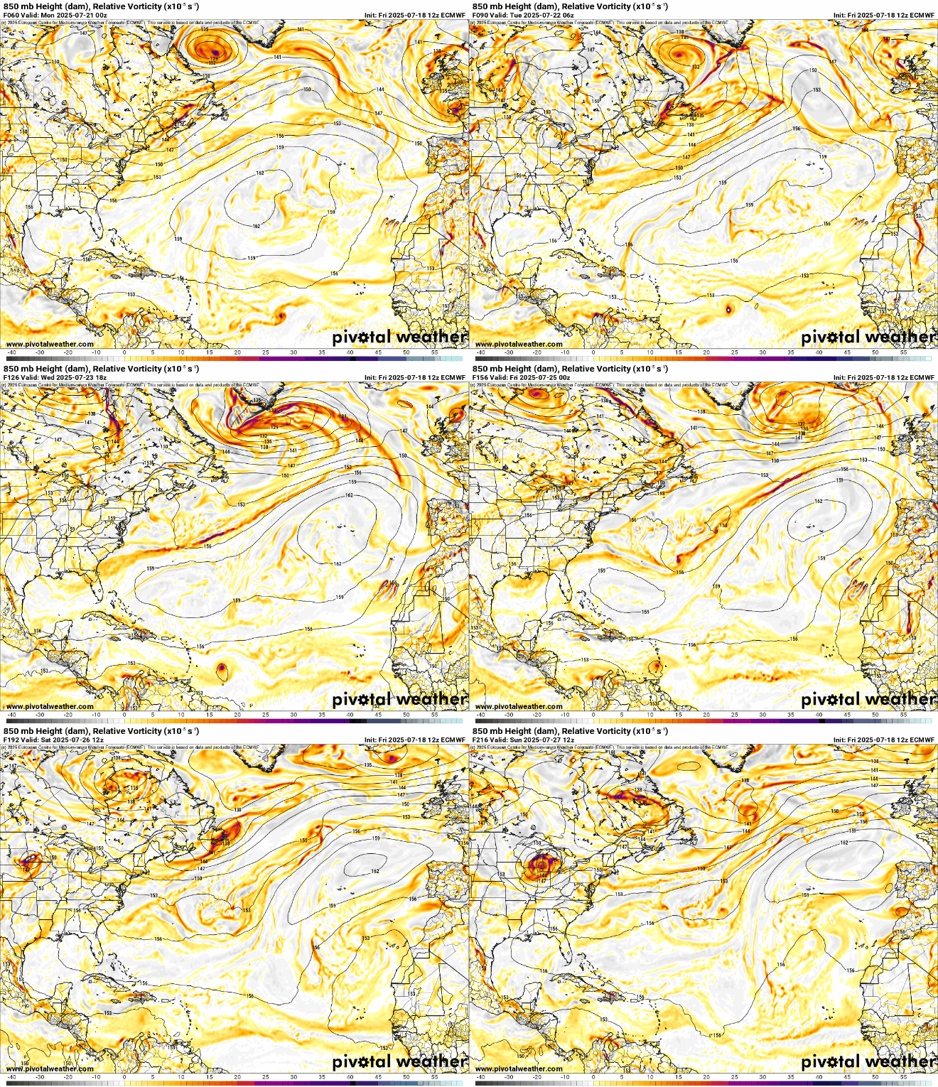
0z euroo operational now shows the MDR wave Deloping around July 26th and approaching the Leeward islands and then Puero Rico on the 28th. Ensembles also back this up. The GFS does not have this, but Canadian does hint at it also (close to the 27th). The GFS does show something forming east of the Carolinas then heading out to sea. And the Euro and GFS both still hint at 93L Looping back off the SE and across Florida into the Gulf. (With really no development)
1 likes
- cycloneye
- Admin

- Posts: 149463
- Age: 69
- Joined: Thu Oct 10, 2002 10:54 am
- Location: San Juan, Puerto Rico
Re: 2025 Global Model Runs Discussion (Out thru day 16)
The 12z run from Euro does not have anything notable, however, it has a strong wave crossing PR on the 27th.


1 likes
Visit the Caribbean-Central America Weather Thread where you can find at first post web cams,radars
and observations from Caribbean basin members Click Here
and observations from Caribbean basin members Click Here
-
TomballEd
- Category 5

- Posts: 1292
- Age: 62
- Joined: Wed Aug 16, 2023 4:52 pm
- Location: Spring/Klein area, not Tomball
Re: 2025 Global Model Runs Discussion (Out thru day 16)
Op Euro had quite a few troughs making it to the SE, which could mean another 93L type system/non system. Euro ensembles still have the MDR signal although they weaken and die as they approach or enter the Caribbean. The 12Z GFS/Canadian ensembles and 0Z Euro ensembles show a lot of shear in the Caribbean.
I don't really expect much before mid-August.
I don't really expect much before mid-August.
3 likes
Re: 2025 Global Model Runs Discussion (Out thru day 16)
MDR's in a near enough timeframe the NHC may put a low chance lemon on the outlook soon. All the major models pick it up (Icon included) but it's fairly weak.


1 likes
Re: 2025 Global Model Runs Discussion (Out thru day 16)
12z Icon showing 3 MDR areas an ex-93l back in the gulf

12z GFS showing the MDR area and what was 93L spinning up again off the SE.


12z GFS showing the MDR area and what was 93L spinning up again off the SE.

1 likes
-
TomballEd
- Category 5

- Posts: 1292
- Age: 62
- Joined: Wed Aug 16, 2023 4:52 pm
- Location: Spring/Klein area, not Tomball
Re: 2025 Global Model Runs Discussion (Out thru day 16)
Dry air dominates most of the basin on the GFS. But 'Son of 93L' may bring more welcome showers and reduced air conditioning bills to my house in a week. GFS ensembles show some support for that.
6Z Euro ensembles like the MDR towards Caribbean system more than the 0Z Euro ensembles. I think the PPV Euro ensembles are out. I have to ask my wife permission. I want to see if 12Z Euro continues the trend towards that MDR system.
6Z Euro ensembles like the MDR towards Caribbean system more than the 0Z Euro ensembles. I think the PPV Euro ensembles are out. I have to ask my wife permission. I want to see if 12Z Euro continues the trend towards that MDR system.
0 likes
Re: 2025 Global Model Runs Discussion (Out thru day 16)
12z Euro is even stronger this run, and takes it over Barbados into the Caribbean where it then dies in the Caribbean Sea graveyard. Does nothing substantial with ex-93L this run.


0 likes
Who is online
Users browsing this forum: No registered users and 75 guests


