https://x.com/RyanMaue/status/1950191354153214106
WPAC: IONA - Post-Tropical - Discussion
Moderator: S2k Moderators
-
cycloneye

- Admin

- Posts: 149275
- Age: 69
- Joined: Thu Oct 10, 2002 10:54 am
- Location: San Juan, Puerto Rico
Re: CPAC: IONA - Hurricane - Discussion
1 likes
Visit the Caribbean-Central America Weather Thread where you can find at first post web cams,radars
and observations from Caribbean basin members Click Here
and observations from Caribbean basin members Click Here
-
cycloneye
- Admin
- Posts: 149275
- Age: 69
- Joined: Thu Oct 10, 2002 10:54 am
- Location: San Juan, Puerto Rico
Re: CPAC: IONA - Hurricane - Discussion
Hurricane Iona Discussion Number 10
NWS Central Pacific Hurricane Center Honolulu HI CP012025
Issued by NWS National Hurricane Center Miami FL
500 AM HST Tue Jul 29 2025
Iona is still rapidly intensifying. Satellite images indicate that
the eye of the hurricane is becoming more distinct, and it is
surrounded by a symmetric ring of cold cloud tops. A blend of the
latest intensity estimates from PHFO, JTWC, and UW-CIMSS supports
increasing the initial intensity to 110 kt, just below category 4
status. Iona has strengthened at a very rapid pace of about 50 kt
over the past 24 hours. Although Iona is very powerful, the wind
field is quite small. The hurricane- and tropical-storm-force
winds are estimated to only extend up to 20 n mi and 70 n mi
from the center, respectively.
The major hurricane could get a little stronger today, and the
official forecast is at the top end of the intensity guidance in
the short term. However, as is the case in most major hurricanes,
internal dynamics like eyewall replacement cycles could occur that
cause fluctuations in the system's strength. Iona is expected to
move into less favorable conditions of drier air, stronger shear,
and slightly cooler SSTs by tonight, and that should end the
strengthening trend and induce weakening. This forecast is in best
agreement with the HCCA model.
Iona has been moving due westward at about 11 kt on the south side
of a narrow mid-level ridge situated across the Hawaiian Islands.
The hurricane should continue westward on the south side of the
ridge during the next few days, and then turn west-northwestward to
northwestward after that when it moves toward the southwestern
periphery of the high pressure system. The models are a little
slower this cycle, and the new track forecast has been adjusted in
that direction. Iona is expected to cross the International Date
Line in a little more than 4 days.
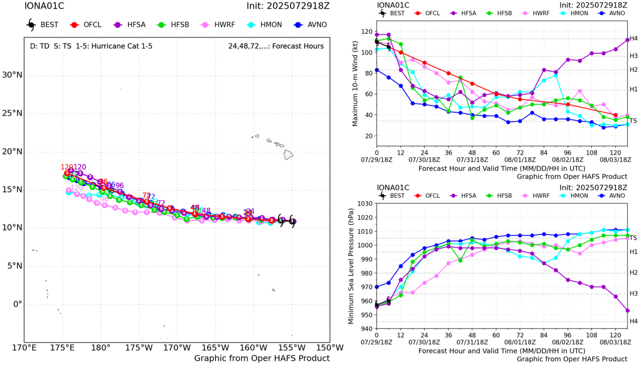
FORECAST POSITIONS AND MAX WINDS
INIT 29/1500Z 10.8N 154.3W 110 KT 125 MPH
12H 30/0000Z 10.8N 156.2W 120 KT 140 MPH
24H 30/1200Z 10.9N 159.1W 105 KT 120 MPH
36H 31/0000Z 11.2N 162.4W 95 KT 110 MPH
48H 31/1200Z 11.6N 166.1W 85 KT 100 MPH
60H 01/0000Z 12.2N 169.8W 75 KT 85 MPH
72H 01/1200Z 13.0N 173.0W 70 KT 80 MPH
96H 02/1200Z 15.0N 179.0W 55 KT 65 MPH
120H 03/1200Z 16.8N 176.0E 40 KT 45 MPH
$$
Forecaster Cangialosi
NWS Central Pacific Hurricane Center Honolulu HI CP012025
Issued by NWS National Hurricane Center Miami FL
500 AM HST Tue Jul 29 2025
Iona is still rapidly intensifying. Satellite images indicate that
the eye of the hurricane is becoming more distinct, and it is
surrounded by a symmetric ring of cold cloud tops. A blend of the
latest intensity estimates from PHFO, JTWC, and UW-CIMSS supports
increasing the initial intensity to 110 kt, just below category 4
status. Iona has strengthened at a very rapid pace of about 50 kt
over the past 24 hours. Although Iona is very powerful, the wind
field is quite small. The hurricane- and tropical-storm-force
winds are estimated to only extend up to 20 n mi and 70 n mi
from the center, respectively.
The major hurricane could get a little stronger today, and the
official forecast is at the top end of the intensity guidance in
the short term. However, as is the case in most major hurricanes,
internal dynamics like eyewall replacement cycles could occur that
cause fluctuations in the system's strength. Iona is expected to
move into less favorable conditions of drier air, stronger shear,
and slightly cooler SSTs by tonight, and that should end the
strengthening trend and induce weakening. This forecast is in best
agreement with the HCCA model.
Iona has been moving due westward at about 11 kt on the south side
of a narrow mid-level ridge situated across the Hawaiian Islands.
The hurricane should continue westward on the south side of the
ridge during the next few days, and then turn west-northwestward to
northwestward after that when it moves toward the southwestern
periphery of the high pressure system. The models are a little
slower this cycle, and the new track forecast has been adjusted in
that direction. Iona is expected to cross the International Date
Line in a little more than 4 days.
FORECAST POSITIONS AND MAX WINDS
INIT 29/1500Z 10.8N 154.3W 110 KT 125 MPH
12H 30/0000Z 10.8N 156.2W 120 KT 140 MPH
24H 30/1200Z 10.9N 159.1W 105 KT 120 MPH
36H 31/0000Z 11.2N 162.4W 95 KT 110 MPH
48H 31/1200Z 11.6N 166.1W 85 KT 100 MPH
60H 01/0000Z 12.2N 169.8W 75 KT 85 MPH
72H 01/1200Z 13.0N 173.0W 70 KT 80 MPH
96H 02/1200Z 15.0N 179.0W 55 KT 65 MPH
120H 03/1200Z 16.8N 176.0E 40 KT 45 MPH
$$
Forecaster Cangialosi
0 likes
Visit the Caribbean-Central America Weather Thread where you can find at first post web cams,radars
and observations from Caribbean basin members Click Here
and observations from Caribbean basin members Click Here
-
Kingarabian

- S2K Supporter

- Posts: 16348
- Joined: Sat Aug 08, 2009 3:06 am
- Location: Honolulu, Hawaii
Re: CPAC: IONA - Hurricane - Discussion
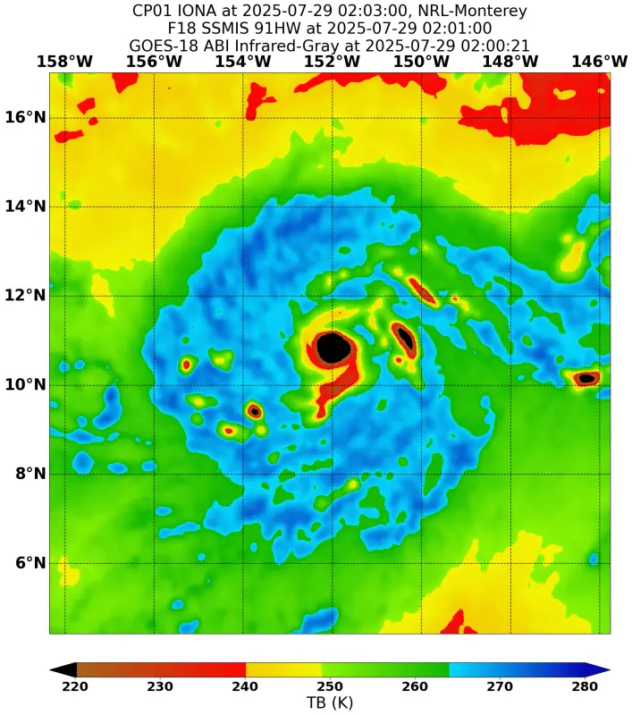
Latest SSMIS pass can't even pickup the eye. Intense eyewall with a very small eye in diameter. This supports upper echelon cat.4 intensity.
3 likes
RIP Kobe Bryant
-
cycloneye
- Admin
- Posts: 149275
- Age: 69
- Joined: Thu Oct 10, 2002 10:54 am
- Location: San Juan, Puerto Rico
Re: CPAC: IONA - Hurricane - Discussion
Hayabusa,Iona is expected to cross the International Date Line in a little more than 4 days. How the models have it at WPAC?
0 likes
Visit the Caribbean-Central America Weather Thread where you can find at first post web cams,radars
and observations from Caribbean basin members Click Here
and observations from Caribbean basin members Click Here
-
DorkyMcDorkface

- Category 4

- Posts: 988
- Age: 28
- Joined: Mon Sep 30, 2019 1:32 pm
- Location: Mid-Atlantic
Re: CPAC: IONA - Hurricane - Discussion: Up to 125 mph
Uniform CDO cooling and warming eye. Gotta be knocking on the door of C4 (if it isn't there already):

5 likes
Please note the thougths expressed by this account are solely those of the user and are from a hobbyist perspective. For more comprehensive analysis, consult an actual professional meteorologist or meteorology agency.
Floyd 1999 | Isabel 2003 | Hanna 2008 | Irene 2011 | Sandy 2012 | Isaias 2020
-
wxman57

- Moderator-Pro Met

- Posts: 23172
- Age: 68
- Joined: Sat Jun 21, 2003 8:06 pm
- Location: Houston, TX (southwest)
Re: CPAC: IONA - Hurricane - Discussion: Up to 125 mph
DorkyMcDorkface wrote:Uniform CDO cooling and warming eye. Gotta be knocking on the door of C4 (if it isn't there already):
https://i.imgur.com/KP2DlcX.gif
I'm estimating 120 kts now, maybe higher. Should be peaking today.
5 likes
-
Kingarabian
- S2K Supporter
- Posts: 16348
- Joined: Sat Aug 08, 2009 3:06 am
- Location: Honolulu, Hawaii
Re: CPAC: IONA - Hurricane - Discussion: Up to 125 mph
Its been averaging a T6.0 for a little while now. Eye warms any further and it'll be a T6.5.
1 likes
RIP Kobe Bryant
-
Yellow Evan

- Professional-Met

- Posts: 16231
- Age: 27
- Joined: Fri Jul 15, 2011 12:48 pm
- Location: Henderson, Nevada/Honolulu, HI
- Contact:
Re: CPAC: IONA - Hurricane - Discussion: Up to 125 mph
I said 120/948 earlier. We’re probably past peak now as the CDO has looked more ragged and the eye is cooling.
2 likes
-
cycloneye
- Admin
- Posts: 149275
- Age: 69
- Joined: Thu Oct 10, 2002 10:54 am
- Location: San Juan, Puerto Rico
Re: CPAC: IONA - Hurricane - Discussion
Since Douglas 2020, there has not been a hurricane with 125 mph until now.
https://x.com/philklotzbach/status/1950224254181519382
https://x.com/philklotzbach/status/1950224254181519382
0 likes
Visit the Caribbean-Central America Weather Thread where you can find at first post web cams,radars
and observations from Caribbean basin members Click Here
and observations from Caribbean basin members Click Here
-
wxman57
- Moderator-Pro Met
- Posts: 23172
- Age: 68
- Joined: Sat Jun 21, 2003 8:06 pm
- Location: Houston, TX (southwest)
Re: CPAC: IONA - Hurricane - Discussion: Up to 125 mph
Yellow Evan wrote:I said 120/948 earlier. We’re probably past peak now as the CDO has looked more ragged and the eye is cooling.
Note that a very small hurricane will have a central pressure much higher than a large hurricane. Pressure probably in the upper 950s or possibly 960-962. Eye is only 6 miles across. Very tight pressure gradient.
1 likes
-
ScottNAtlanta

- Category 5

- Posts: 2535
- Joined: Sat May 25, 2013 3:11 pm
- Location: Atlanta, GA
Re: CPAC: IONA - Hurricane - Discussion
As of last advisory
Moving: W at 13 mph
Min pressure: 957 mb
Max sustained: 125 mph
Moving: W at 13 mph
Min pressure: 957 mb
Max sustained: 125 mph
1 likes
The posts in this forum are NOT official forecast and should not be used as such. They are just the opinion of the poster and may or may not be backed by sound meteorological data. They are NOT endorsed by any professional institution or storm2k.org. For official information, please refer to the NHC and NWS products.
-
StormWeather

- Category 1

- Posts: 475
- Joined: Wed Jun 05, 2024 2:34 pm
Re: CPAC: IONA - Hurricane - Discussion
To me it seems recently that Iona attempted to recover its eye briefly, but it failed.
0 likes
Just an average cyclone tracker
The posts in this forum are NOT official forecasts and should not be used as such. They are just the opinion of the poster and may or may not be backed by sound meteorological data. They are NOT endorsed by any professional institution or storm2k.org. For official information, please refer to the NHC and NWS products
The posts in this forum are NOT official forecasts and should not be used as such. They are just the opinion of the poster and may or may not be backed by sound meteorological data. They are NOT endorsed by any professional institution or storm2k.org. For official information, please refer to the NHC and NWS products
-
ElectricStorm

- Category 5
- Posts: 5139
- Age: 25
- Joined: Tue Aug 13, 2019 11:23 pm
- Location: Norman, OK
Re: CPAC: IONA - Hurricane - Discussion
Looks like it's starting to feel the shear now. Probably well into the Cat 4 range earlier, hopefully we see an increase to 120kts in the TCR although it may have been higher than that.
2 likes
B.S Meteorology, University of Oklahoma '25
Please refer to the NHC, NWS, or SPC for official information.
Please refer to the NHC, NWS, or SPC for official information.
-
Kingarabian
- S2K Supporter
- Posts: 16348
- Joined: Sat Aug 08, 2009 3:06 am
- Location: Honolulu, Hawaii
Re: CPAC: IONA - Hurricane - Discussion
Dry air getting inside and it looks like this maybe the end. Never did become a predominant buzzsaw/gain annular characteristics.
1 likes
RIP Kobe Bryant
-
Yellow Evan
- Professional-Met
- Posts: 16231
- Age: 27
- Joined: Fri Jul 15, 2011 12:48 pm
- Location: Henderson, Nevada/Honolulu, HI
- Contact:
Re: CPAC: IONA - Hurricane - Discussion
Kingarabian wrote:Dry air getting inside and it looks like this maybe the end. Never did become a predominant buzzsaw/gain annular characteristics.
Harder this far west because shear tends to be westerly in this area of the world unless there's a strong La Nina to push rising motion from the MC/WPAC into the IO. The more classic annulars typically occur around 125-130W.
3 likes
-
cycloneye
- Admin
- Posts: 149275
- Age: 69
- Joined: Thu Oct 10, 2002 10:54 am
- Location: San Juan, Puerto Rico
Re: CPAC: IONA - Hurricane - Discussion
Hurricane Iona Discussion Number 11
NWS Central Pacific Hurricane Center Honolulu HI CP012025
Issued by NWS National Hurricane Center Miami FL
1100 AM HST Tue Jul 29 2025
After rapidly intensifying over the past day or so, Iona's strength
appears to have leveled off. The eye of the hurricane is not quite
as distinct as it was a few hours ago and the convective pattern is
slightly less symmetric. The initial intensity is held at 110 kt,
but this is near the high end of the latest satellite intensity
estimates. Although Iona is quite powerful, its wind field remains
compact. The hurricane- and tropical-storm-force wind radii are
estimated to only extend up to 25 n mi and 80 n mi from the center,
respectively.
The major hurricane is likely near its peak intensity. Water vapor
images show a large area of dry and likely stable air just west of
the system, and this stable air combined with increasing shear
should cause Iona to steadily weaken during the next several days.
The new forecast is a touch lower than the previous one and lies
generally near the middle of the guidance envelope.
Iona has been moving due westward at about 12 kt on the south side
of a narrow mid-level ridge situated across the Hawaiian Islands.
The hurricane should continue westward on the south side of the
ridge during the next few days, and then turn west-northwestward to
northwestward after that when it moves toward the southwestern
periphery of the high pressure system. The models are again a
little slower this cycle, and the new track forecast has been
adjusted in that direction. Iona is expected to cross the
International Date Line in about 4 days.
FORECAST POSITIONS AND MAX WINDS
INIT 29/2100Z 10.9N 155.7W 110 KT 125 MPH
12H 30/0600Z 11.0N 157.7W 100 KT 115 MPH
24H 30/1800Z 11.2N 160.7W 90 KT 105 MPH
36H 31/0600Z 11.5N 164.1W 80 KT 90 MPH
48H 31/1800Z 11.9N 167.7W 70 KT 80 MPH
60H 01/0600Z 12.6N 171.0W 60 KT 70 MPH
72H 01/1800Z 13.5N 174.0W 55 KT 65 MPH
96H 02/1800Z 15.3N 179.6W 50 KT 60 MPH
120H 03/1800Z 17.2N 175.6E 40 KT 45 MPH
$$
Forecaster Cangialosi
1 likes
Visit the Caribbean-Central America Weather Thread where you can find at first post web cams,radars
and observations from Caribbean basin members Click Here
and observations from Caribbean basin members Click Here
-
Hurricane2022

- Category 5
- Posts: 2016
- Joined: Tue Aug 23, 2022 11:38 pm
- Location: Araçatuba, Brazil
Re: CPAC: IONA - Hurricane - Discussion
0 likes
Sorry for the bad English sometimes...!
For reliable and detailed information for any meteorological phenomenon, please consult the National Hurricane Center, Joint Typhoon Warning Center , or your local Meteo Center.
--------
ECCE OMNIA NOVA FACIAM (Ap 21,5).
For reliable and detailed information for any meteorological phenomenon, please consult the National Hurricane Center, Joint Typhoon Warning Center , or your local Meteo Center.
--------
ECCE OMNIA NOVA FACIAM (Ap 21,5).

Re: CPAC: IONA - Hurricane - Discussion
cycloneye wrote:Hayabusa,Iona is expected to cross the International Date Line in a little more than 4 days. How the models have it at WPAC?
12z Euro keeps it as a TS as it enters the WPac, 18z is weaker, other 12z global models have it dissipating as it nears the dateline
1 likes
ヤンデレ女が寝取られるているのを見たい!!!
ECMWF ensemble NWPAC plots: https://ecmwfensnwpac.imgbb.com/
Multimodel NWPAC plots: https://multimodelnwpac.imgbb.com/
GFS Ensemble NWPAC plots (16 & 35 day forecast): https://gefsnwpac.imgbb.com/
Plots updated automatically
ECMWF ensemble NWPAC plots: https://ecmwfensnwpac.imgbb.com/
Multimodel NWPAC plots: https://multimodelnwpac.imgbb.com/
GFS Ensemble NWPAC plots (16 & 35 day forecast): https://gefsnwpac.imgbb.com/
Plots updated automatically
Re: CPAC: IONA - Hurricane - Discussion
18z HFSA intensifies to near cat 4 at the end of the run
1 likes
ヤンデレ女が寝取られるているのを見たい!!!
ECMWF ensemble NWPAC plots: https://ecmwfensnwpac.imgbb.com/
Multimodel NWPAC plots: https://multimodelnwpac.imgbb.com/
GFS Ensemble NWPAC plots (16 & 35 day forecast): https://gefsnwpac.imgbb.com/
Plots updated automatically
ECMWF ensemble NWPAC plots: https://ecmwfensnwpac.imgbb.com/
Multimodel NWPAC plots: https://multimodelnwpac.imgbb.com/
GFS Ensemble NWPAC plots (16 & 35 day forecast): https://gefsnwpac.imgbb.com/
Plots updated automatically
Re: CPAC: IONA - Hurricane - Discussion
1 likes
ヤンデレ女が寝取られるているのを見たい!!!
ECMWF ensemble NWPAC plots: https://ecmwfensnwpac.imgbb.com/
Multimodel NWPAC plots: https://multimodelnwpac.imgbb.com/
GFS Ensemble NWPAC plots (16 & 35 day forecast): https://gefsnwpac.imgbb.com/
Plots updated automatically
ECMWF ensemble NWPAC plots: https://ecmwfensnwpac.imgbb.com/
Multimodel NWPAC plots: https://multimodelnwpac.imgbb.com/
GFS Ensemble NWPAC plots (16 & 35 day forecast): https://gefsnwpac.imgbb.com/
Plots updated automatically
Who is online
Users browsing this forum: No registered users and 28 guests