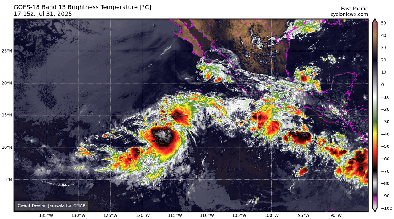
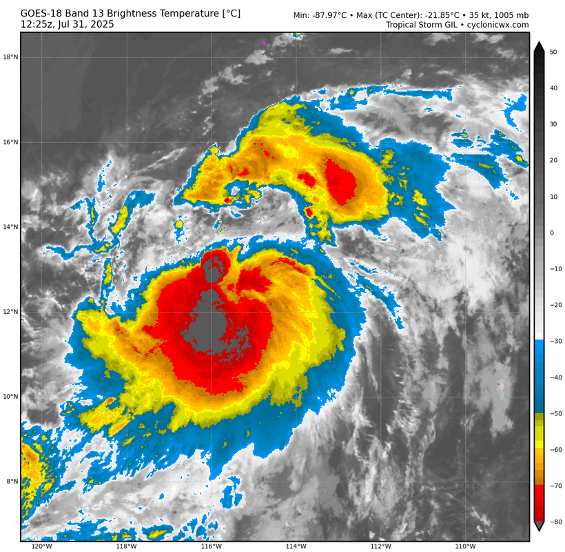
https://ftp.nhc.noaa.gov/atcf/btk/bep992025.dat
EPAC: GIL - Tropical Storm - Discussion
Moderators: hurricanetrack, S2k Moderators

The posts in this forum are NOT official forecasts and should not be used as such. They are just the opinion of the poster and may or may not be backed by sound meteorological data. They are NOT endorsed by any professional institution or STORM2K. For official information, please refer to products from the National Hurricane Center and National Weather Service.
- ElectricStorm
- Category 5
- Posts: 5057
- Age: 24
- Joined: Tue Aug 13, 2019 11:23 pm
- Location: Skiatook, OK / Norman, OK
EPAC: GIL - Tropical Storm - Discussion
0 likes
B.S Meteorology, University of Oklahoma '25
Please refer to the NHC, NWS, or SPC for official information.
- cycloneye
- Admin
- Posts: 145568
- Age: 68
- Joined: Thu Oct 10, 2002 10:54 am
- Location: San Juan, Puerto Rico
Re: EPAC: INVEST 99E - Discussion
South of Southwestern Mexico (EP99):
A large area of disorganized showers and thunderstorms located a
few hundred miles south of the southern coast of Mexico are
associated with a trough of low pressure. Environmental
conditions are expected to be conducive for development, and a
tropical depression is likely to form during the middle part of
this week as it moves west-northwestward or northwestward at 10
to 15 mph remaining well offshore of the southwestern coast of
Mexico.
* Formation chance through 48 hours...medium...60 percent.
* Formation chance through 7 days...high...90 percent.
0 likes
Visit the Caribbean-Central America Weather Thread where you can find at first post web cams,radars
and observations from Caribbean basin members Click Here
- cycloneye
- Admin
- Posts: 145568
- Age: 68
- Joined: Thu Oct 10, 2002 10:54 am
- Location: San Juan, Puerto Rico
Re: EPAC: INVEST 99E - Discussion
South of Southwestern Mexico (EP99):
A large area of disorganized showers and thunderstorms located a few
hundred miles south of the southern coast of Mexico is associated
with a trough of low pressure. Environmental conditions are
expected to be conducive for development, and a tropical depression
is likely to form during the next couple of days while the system
moves west-northwestward around 15 mph, remaining well offshore of
the southwestern coast of Mexico.
* Formation chance through 48 hours...high...70 percent.
* Formation chance through 7 days...high...90 percent
0 likes
Visit the Caribbean-Central America Weather Thread where you can find at first post web cams,radars
and observations from Caribbean basin members Click Here
- ElectricStorm
- Category 5
- Posts: 5057
- Age: 24
- Joined: Tue Aug 13, 2019 11:23 pm
- Location: Skiatook, OK / Norman, OK
Re: EPAC: INVEST 99E - Discussion
GFS has been consistent in showing this remaining on the weaker side. Develops slowly and moves too far north for it to get strong. Will probably need to develop quickly to have a chance to become a hurricane.
The 0/30 AOI behind it might be a better candidate for something strong if the GFS is correct.
0 likes
B.S Meteorology, University of Oklahoma '25
Please refer to the NHC, NWS, or SPC for official information.
- cycloneye
- Admin
- Posts: 145568
- Age: 68
- Joined: Thu Oct 10, 2002 10:54 am
- Location: San Juan, Puerto Rico
Re: EPAC: INVEST 99E - Discussion
South of Southwestern Mexico (EP99):
A large area of disorganized showers and thunderstorms located about
500 miles south of the southwestern coast of Mexico is associated
with a trough of low pressure. Environmental conditions appear
conducive for development, and a tropical depression is likely to
form during the next couple of days while the system moves
west-northwestward around 15 mph, remaining well offshore of the
southwestern coast of Mexico.
* Formation chance through 48 hours...high...80 percent.
* Formation chance through 7 days...high...90 percent.
0 likes
Visit the Caribbean-Central America Weather Thread where you can find at first post web cams,radars
and observations from Caribbean basin members Click Here
- cycloneye
- Admin
- Posts: 145568
- Age: 68
- Joined: Thu Oct 10, 2002 10:54 am
- Location: San Juan, Puerto Rico
Re: EPAC: INVEST 99E - Discussion
South of Southwestern Mexico (EP99):
A trough of low pressure located about 500 miles south of the
southwestern coast of Mexico is producing a large area of
disorganized showers and thunderstorms. Environmental conditions
appear conducive for development, and a tropical depression is
likely to form during the next couple of days while the system moves
west-northwestward around 15 mph, remaining well offshore of the
southwestern coast of Mexico.
* Formation chance through 48 hours...high...80 percent.
* Formation chance through 7 days...high...90 percent.
0 likes
Visit the Caribbean-Central America Weather Thread where you can find at first post web cams,radars
and observations from Caribbean basin members Click Here
- cycloneye
- Admin
- Posts: 145568
- Age: 68
- Joined: Thu Oct 10, 2002 10:54 am
- Location: San Juan, Puerto Rico
Re: EPAC: INVEST 99E - Discussion
South of Southwestern Mexico (EP99):
Shower activity associated with a trough of low pressure located
several hundred miles southwest of the southwestern coast of Mexico
has become a little better organized since yesterday. Environmental
conditions appear conducive for development, and a tropical
depression is likely to form during the next day or two while the
system moves west-northwestward around 15 mph, remaining well
offshore of the southwestern coast of Mexico.
* Formation chance through 48 hours...high...80 percent.
* Formation chance through 7 days...high...90 percent.
0 likes
Visit the Caribbean-Central America Weather Thread where you can find at first post web cams,radars
and observations from Caribbean basin members Click Here
- cycloneye
- Admin
- Posts: 145568
- Age: 68
- Joined: Thu Oct 10, 2002 10:54 am
- Location: San Juan, Puerto Rico
Re: EPAC: INVEST 99E - Discussion
is getting organized and is close to TD status.


0 likes
Visit the Caribbean-Central America Weather Thread where you can find at first post web cams,radars
and observations from Caribbean basin members Click Here
- cycloneye
- Admin
- Posts: 145568
- Age: 68
- Joined: Thu Oct 10, 2002 10:54 am
- Location: San Juan, Puerto Rico
Re: EPAC: INVEST 99E - Discussion
West-Southwest of Southwestern Mexico (EP99):
Showers and thunderstorms associated with a trough of low pressure
located several hundred miles west-southwest of the southwestern
coast of Mexico have become a little better organized since
yesterday. Environmental conditions appear conducive for additional
development, and a tropical depression is likely to form during the
next day or two while the system moves west-northwestward around 15
mph, remaining well offshore of the southwestern coast of Mexico.
* Formation chance through 48 hours...high...90 percent.
* Formation chance through 7 days...high...90 percent.
0 likes
Visit the Caribbean-Central America Weather Thread where you can find at first post web cams,radars
and observations from Caribbean basin members Click Here
- Kingarabian
- S2K Supporter
- Posts: 16012
- Joined: Sat Aug 08, 2009 3:06 am
- Location: Honolulu, Hawaii
Re: EPAC: INVEST 99E - Discussion
Current structure doesn't support quick intensification.
0 likes
RIP Kobe Bryant
-
- Category 5
- Posts: 9158
- Age: 39
- Joined: Thu Jul 06, 2017 1:51 am
- cycloneye
- Admin
- Posts: 145568
- Age: 68
- Joined: Thu Oct 10, 2002 10:54 am
- Location: San Juan, Puerto Rico
Re: EPAC: INVEST 99E - Discussion
Maybe an upgrade?
EP, 99, 2025073100, , BEST, 0, 125N, 1134W, 25, 1007, DB
0 likes
Visit the Caribbean-Central America Weather Thread where you can find at first post web cams,radars
and observations from Caribbean basin members Click Here
- Hurricane2022
- Category 5
- Posts: 1574
- Joined: Tue Aug 23, 2022 11:38 pm
- Location: Araçatuba, Brazil
Re: EPAC: INVEST 99E - Discussion
Now TS GIL.
0 likes
Sorry for the bad English sometimes...!
For reliable and detailed information for any meteorological phenomenon, please consult the National Hurricane Center, Joint Typhoon Warning Center , or your local Meteo Center.
--------
Una cvm Christo, pro Christo, et in Christo. Sit nomen Domini benedictvm.
For reliable and detailed information for any meteorological phenomenon, please consult the National Hurricane Center, Joint Typhoon Warning Center , or your local Meteo Center.
--------
Una cvm Christo, pro Christo, et in Christo. Sit nomen Domini benedictvm.
- cycloneye
- Admin
- Posts: 145568
- Age: 68
- Joined: Thu Oct 10, 2002 10:54 am
- Location: San Juan, Puerto Rico
Re: EPAC: GIL - Tropical Storm - Discussion
Tropical Storm Gil Discussion Number 1
NWS National Hurricane Center Miami FL EP072025
1100 PM HST Wed Jul 30 2025
Satellite imagery indicates that the disturbance NHC has been
tracking for the past several days has become much better organized
during the past 12 hours. The latest subjective Dvorak estimates
are 2.5/35 kt from TAFB and 1.5/25 kt from SAB. A 0457 UTC ASCAT-B
pass showed a well-defined circulation with peak winds near 35 kt.
Since that time, the convective organization has continued to
improve significantly, with a central convective area containing
cloud tops that are becoming colder and more circular on infrared
imagery, along with developing banding features. The system is
upgraded to Tropical Storm Gil based on the above data, and the
initial intensity estimate is 40 kt to reflect the improved
structure since the time of the ASCAT pass.
Gil is moving westward, or 275/13 kt. The track forecast is fairly
straightforward. A mid-level ridge to the north of Gil will steer
the cyclone west-northwestward for the next 3 to 4 days. As Gil
weakens and becomes shallow, it should bend more to the west by day
4. The track forecast is near the middle of the guidance envelope
and is close to the TVCE consensus.
Gil is currently located in a moist environment with warm
sea-surface temperatures and low to moderate vertical wind shear,
and the cyclone is forecast to strengthen to a hurricane over the
next 36 h. The shear is forecast to decrease further over the next
24 h while upper-level divergence increases. Given the current
impressive outflow and relatively fast recent development trends, it
is possible Gil could strengthen a bit more than forecast over the
next day or two. However, Gil is forecast to reach colder water and
more stable conditions by hour 48 as it gains latitude, which should
lead to weakening. The NHC intensity forecast is near the middle of
the guidance envelope. Gil is forecast to lose its convection and
become a remnant low by day 5.
FORECAST POSITIONS AND MAX WINDS
INIT 31/0900Z 12.7N 115.1W 40 KT 45 MPH
12H 31/1800Z 13.4N 117.0W 50 KT 60 MPH
24H 01/0600Z 14.5N 119.6W 60 KT 70 MPH
36H 01/1800Z 15.7N 122.5W 65 KT 75 MPH
48H 02/0600Z 17.1N 125.7W 65 KT 75 MPH
60H 02/1800Z 18.6N 129.1W 60 KT 70 MPH
72H 03/0600Z 20.1N 132.4W 55 KT 65 MPH
96H 04/0600Z 21.7N 138.6W 35 KT 40 MPH
120H 05/0600Z 22.3N 144.3W 30 KT 35 MPH...POST-TROP/REMNT LOW
$$
Forecaster Hagen
0 likes
Visit the Caribbean-Central America Weather Thread where you can find at first post web cams,radars
and observations from Caribbean basin members Click Here
- Kingarabian
- S2K Supporter
- Posts: 16012
- Joined: Sat Aug 08, 2009 3:06 am
- Location: Honolulu, Hawaii
Re: EPAC: INVEST 99E - Discussion
Kingarabian wrote:Current structure doesn't support quick intensification.
Quite the improvement

0 likes
RIP Kobe Bryant
- cycloneye
- Admin
- Posts: 145568
- Age: 68
- Joined: Thu Oct 10, 2002 10:54 am
- Location: San Juan, Puerto Rico
Re: EPAC: GIL - Tropical Storm - Discussion
EP, 07, 2025073112, , BEST, 0, 129N, 1156W, 45, 1000, TS
0 likes
Visit the Caribbean-Central America Weather Thread where you can find at first post web cams,radars
and observations from Caribbean basin members Click Here
- cycloneye
- Admin
- Posts: 145568
- Age: 68
- Joined: Thu Oct 10, 2002 10:54 am
- Location: San Juan, Puerto Rico
Re: EPAC: GIL - Tropical Storm - Discussion
Tropical Storm Gil Discussion Number 2
NWS National Hurricane Center Miami FL EP072025
500 AM HST Thu Jul 31 2025
Gil continues to become better organized this morning.
Geostationary infrared imagery show steady bursts of embedded deep
convection with cloud top temperatures less than -80 degrees
Celsius. Objective and subjective satellite intensity estimates
have increased this cycle and range between 35 to 46 kt. The
initial intensity is raised to 45 kt, closest to the TAFB and
UW-CIMSS DPRINT estimates.
The storm is moving at 280/12 kt along the southern side of a
subtropical ridge. This mid-level ridge will steer Gil generally
west-northwestward for the next few days, with some increase in
forward motion. By day 4, the weaker, more shallow cyclone is
expected to turn more westward in the low-level flow. The track
guidance envelope remains tightly clustered and only minor changes
were made to the latest NHC track forecast.
Atmospheric and oceanic conditions appear generally conducive for
Gil to continue strengthening. Statistical indicators even suggest
an above average possibility of strong-to-rapid intensification in
the next day or so. Thus, the predicted peak intensity has been
raised to 75 kt in 36 h based on these factors and an overall
increase in the model intensity guidance. Gil is still expected to
reach cooler waters and a dry, stable airmass in a couple of days
which will cause steady weakening. The latest NHC intensity
forecast now shows Gil becoming a post-tropical cyclone by day 4,
when global model show the cyclone will lose all convection.
FORECAST POSITIONS AND MAX WINDS
INIT 31/1500Z 13.2N 116.2W 45 KT 50 MPH
12H 01/0000Z 13.9N 118.1W 60 KT 70 MPH
24H 01/1200Z 15.0N 120.9W 70 KT 80 MPH
36H 02/0000Z 16.4N 124.0W 75 KT 85 MPH
48H 02/1200Z 17.8N 127.4W 75 KT 85 MPH
60H 03/0000Z 19.2N 130.8W 65 KT 75 MPH
72H 03/1200Z 20.3N 134.1W 55 KT 65 MPH
96H 04/1200Z 21.7N 140.3W 35 KT 40 MPH...POST-TROPICAL
120H 05/1200Z 22.2N 145.8W 30 KT 35 MPH...POST-TROP/REMNT LOW
$$
Forecaster Bucci
0 likes
Visit the Caribbean-Central America Weather Thread where you can find at first post web cams,radars
and observations from Caribbean basin members Click Here
- cycloneye
- Admin
- Posts: 145568
- Age: 68
- Joined: Thu Oct 10, 2002 10:54 am
- Location: San Juan, Puerto Rico
Re: EPAC: GIL - Tropical Storm - Discussion
0 likes
Visit the Caribbean-Central America Weather Thread where you can find at first post web cams,radars
and observations from Caribbean basin members Click Here
- Kingarabian
- S2K Supporter
- Posts: 16012
- Joined: Sat Aug 08, 2009 3:06 am
- Location: Honolulu, Hawaii
Return to “Active Storms/Invests - Atlantic/EastPAC/CentralPAC/MED”
Who is online
Users browsing this forum: No registered users and 13 guests