Tropical Wave in the Eastern Atlantic (Is Invest 96L)
Moderator: S2k Moderators
Forum rules

The posts in this forum are NOT official forecasts and should not be used as such. They are just the opinion of the poster and may or may not be backed by sound meteorological data. They are NOT endorsed by any professional institution or STORM2K. For official information, please refer to products from the National Hurricane Center and National Weather Service.
-
WeatherBoy2000
- Category 1

- Posts: 463
- Joined: Mon Apr 10, 2023 9:29 am
Re: Tropical Wave in the Eastern Atlantic
Looks like the gfs/gefs has caved to the euro on a recurving wave that may eventually develop in the subtropics.
0 likes

Re: Tropical Wave in the Eastern Atlantic
ScottNAtlanta wrote:BobHarlem wrote:Most concentrated run of the Euro ensembles yet here
https://i.imgur.com/XxQ0T0B.png
If that is the case, we should have some idea in 3 days if it is correct
The Euro historically has a habit of tracking storms NW OTS east of Bermuda in the early runs when the systems are just forming near the Cape Verde island longitude.
Weaker development a little further south than projected due to the ITCZ being a little south early in the Cape Verde Season leads to delay in the spin up.
Run after run they drift weak and west dependent on the ITCZ for moisture until they are too far west to feel the weakness to the north and get trapped under the ridge.
That is why we are seeing the early classic track flip flop from Bermuda to gulf, Bermuda, gulf.
GFS may be the model to follow this time.
2 likes
-
Blown Away

- S2K Supporter

- Posts: 10253
- Joined: Wed May 26, 2004 6:17 am
Re: Tropical Wave in the Eastern Atlantic
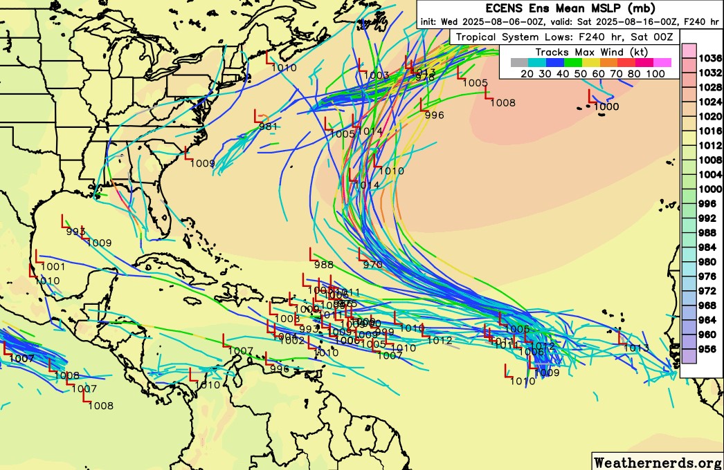
The GFS/GEFS totally caved to the EURO/ECENS with this TW...
0 likes
Hurricane Eye Experience: David 79, Irene 99, Frances 04, Jeanne 04, Wilma 05… Hurricane Brush Experience: Andrew 92, Erin 95, Floyd 99, Matthew 16, Irma 17, Ian 22, Nicole 22…
-
cycloneye

- Admin

- Posts: 149703
- Age: 69
- Joined: Thu Oct 10, 2002 10:54 am
- Location: San Juan, Puerto Rico
Re: Tropical Wave in the Eastern Atlantic
Central Tropical Atlantic:
A tropical wave over the eastern tropical Atlantic continues to
produce a broad area of disorganized showers and thunderstorms.
Environmental conditions are forecast to be conducive for gradual
development during the next few days, and a tropical depression
could form late this week or over the weekend as the system moves
generally west-northwestward to northwestward across the central
tropical and subtropical Atlantic.
* Formation chance through 48 hours...low...20 percent.
* Formation chance through 7 days...medium...60 percent.

0 likes
Visit the Caribbean-Central America Weather Thread where you can find at first post web cams,radars
and observations from Caribbean basin members Click Here
and observations from Caribbean basin members Click Here
-
TomballEd
- Category 5

- Posts: 1318
- Age: 62
- Joined: Wed Aug 16, 2023 4:52 pm
- Location: Spring/Klein area, not Tomball
Re: Tropical Wave in the Eastern Atlantic
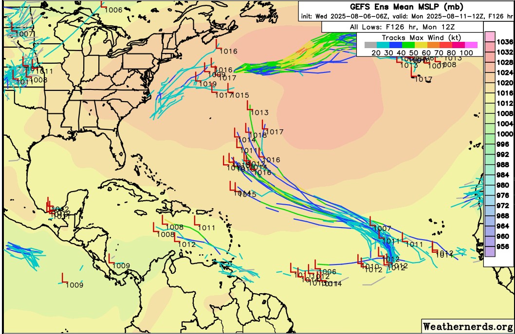
All the 6Z Euro ensembles that develop this quickly recurve it. About 10% of the ensembles take the wave that doesn't develop towards the Caribbean. At least some of the 40% odds won't develop (100% - 60%) would continue W and wait to develop. The number of GEFS members that wait until near or inside the Caribbean is also 10% Caribbean looks less hostile than I'd expect for early/mid August. The scenario about the 40% chance of not developing may have a continued NHC formation outlook which would keep it in this thread.


Last edited by TomballEd on Wed Aug 06, 2025 12:37 pm, edited 1 time in total.
0 likes
-
wxman57

- Moderator-Pro Met

- Posts: 23175
- Age: 68
- Joined: Sat Jun 21, 2003 8:06 pm
- Location: Houston, TX (southwest)
Re: Tropical Wave in the Eastern Atlantic
Azores-Bermuda High is weak at present. Any development would track northward well east of the Caribbean.
3 likes
-
convergencezone2
- Tropical Low

- Posts: 11
- Joined: Tue Jul 29, 2025 4:03 pm
Re: Tropical Wave in the Eastern Atlantic
wxman57 wrote:Azores-Bermuda High is weak at present. Any development would track northward well east of the Caribbean.
Unfortunately that's probably not going to be the case for much longer if you look as some of the future development threads.
0 likes
-
convergencezone2
- Tropical Low
- Posts: 11
- Joined: Tue Jul 29, 2025 4:03 pm
Re: Tropical Wave in the Eastern Atlantic
Guess this will be the one to prime the pump for future storms.
Last edited by convergencezone2 on Wed Aug 06, 2025 12:38 pm, edited 1 time in total.
2 likes
-
cycloneye
- Admin
- Posts: 149703
- Age: 69
- Joined: Thu Oct 10, 2002 10:54 am
- Location: San Juan, Puerto Rico
Re: Tropical Wave in the Eastern Atlantic
Central Tropical Atlantic:
Shower and thunderstorm activity has become a bit more concentrated
with a tropical wave in the eastern tropical Atlantic. Environmental
conditions are forecast to be conducive for gradual development
during the next few days, and a tropical depression could form late
this week or over the weekend as the system moves generally
west-northwestward to northwestward across the central tropical and
subtropical Atlantic.
* Formation chance through 48 hours...low...30 percent.
* Formation chance through 7 days...medium...60 percent.
0 likes
Visit the Caribbean-Central America Weather Thread where you can find at first post web cams,radars
and observations from Caribbean basin members Click Here
and observations from Caribbean basin members Click Here
-
MEANINGLESS_NUMBERS
- Category 2

- Posts: 503
- Joined: Mon Nov 02, 2020 1:43 pm
Re: Tropical Wave in the Eastern Atlantic
12z GFS drags this over Bermuda as a sloppy mess and blows up the wave behind as the real deal.
0 likes
Emily '87, Felix '95, Gert '99, Fabian '03, Humberto '19, Paulette '20, Teddy '20, Fiona '22, Lee '23, Ernesto '24, Humberto/Imelda '25
-
StormWeather

- Category 1
- Posts: 477
- Joined: Wed Jun 05, 2024 2:34 pm
Re: Tropical Wave in the Eastern Atlantic
Invest 96L is up
(Don’t know at all 100% how to link another thread to this thread in the words “Invest 96L is up”)
(Don’t know at all 100% how to link another thread to this thread in the words “Invest 96L is up”)
0 likes
Just an average cyclone tracker
The posts in this forum are NOT official forecasts and should not be used as such. They are just the opinion of the poster and may or may not be backed by sound meteorological data. They are NOT endorsed by any professional institution or storm2k.org. For official information, please refer to the NHC and NWS products
The posts in this forum are NOT official forecasts and should not be used as such. They are just the opinion of the poster and may or may not be backed by sound meteorological data. They are NOT endorsed by any professional institution or storm2k.org. For official information, please refer to the NHC and NWS products
-
wxman57
- Moderator-Pro Met
- Posts: 23175
- Age: 68
- Joined: Sat Jun 21, 2003 8:06 pm
- Location: Houston, TX (southwest)
Re: Tropical Wave in the Eastern Atlantic
convergencezone2 wrote:wxman57 wrote:Azores-Bermuda High is weak at present. Any development would track northward well east of the Caribbean.
Unfortunately that's probably not going to be the case for much longer if you look as some of the future development threads.
Long-range models indicate that the weaker Bermuda high would continue into October. That won't protect the NE Caribbean or East U.S. Coast, but it should keep long-tracked hurricanes from entering the Gulf. Close-in development, say NW Caribbean or Gulf, is always a possibility.
2 likes
-
ScottNAtlanta

- Category 5
- Posts: 2535
- Joined: Sat May 25, 2013 3:11 pm
- Location: Atlanta, GA
Re: Tropical Wave in the Eastern Atlantic
Looks like it's go time

3 likes
The posts in this forum are NOT official forecast and should not be used as such. They are just the opinion of the poster and may or may not be backed by sound meteorological data. They are NOT endorsed by any professional institution or storm2k.org. For official information, please refer to the NHC and NWS products.
Who is online
Users browsing this forum: AnnularCane, pepecool20 and 185 guests