Tropical Wave Over the Far Eastern Atlantic: (Is Invest 97L)

This is the general tropical discussion area. Anyone can take their shot at predicting a storms path.

Moderator: S2k Moderators

Forum rules

The posts in this forum are NOT official forecasts and should not be used as such. They are just the opinion of the poster and may or may not be backed by sound meteorological data. They are NOT endorsed by any professional institution or STORM2K. For official information, please refer to products from the National Hurricane Center and National Weather Service.

Help Support Storm2K
Message
Author
convergencezone2
Tropical Wave
Tropical Wave
Posts: 9
Joined: Tue Jul 29, 2025 4:03 pm

Re: Tropical Wave Over West Africa

#121 Postby convergencezone2 » Fri Aug 08, 2025 1:30 pm

cycloneye wrote:The train. choo-choo. :D

 https://x.com/ZackFradellaWx/status/1953860739157860382


yep the trains have left the station for sure! 7 pages regarding a wave that hasn't even moved off the coast yet shows our thirst for the dopamine hits of development.

disclaimer: as thirsty as we are for activity, keep in mind, it reflects no desire to see death and destruction, because the weather is going to do what the weather is going to do. It's more about the excitement of watching storms come together.
7 likes   

LarryWx
S2K Supporter
S2K Supporter
Posts: 6409
Joined: Sun Sep 07, 2003 2:04 pm
Location: GA

Re: Tropical Wave Over West Africa

#122 Postby LarryWx » Fri Aug 08, 2025 1:51 pm

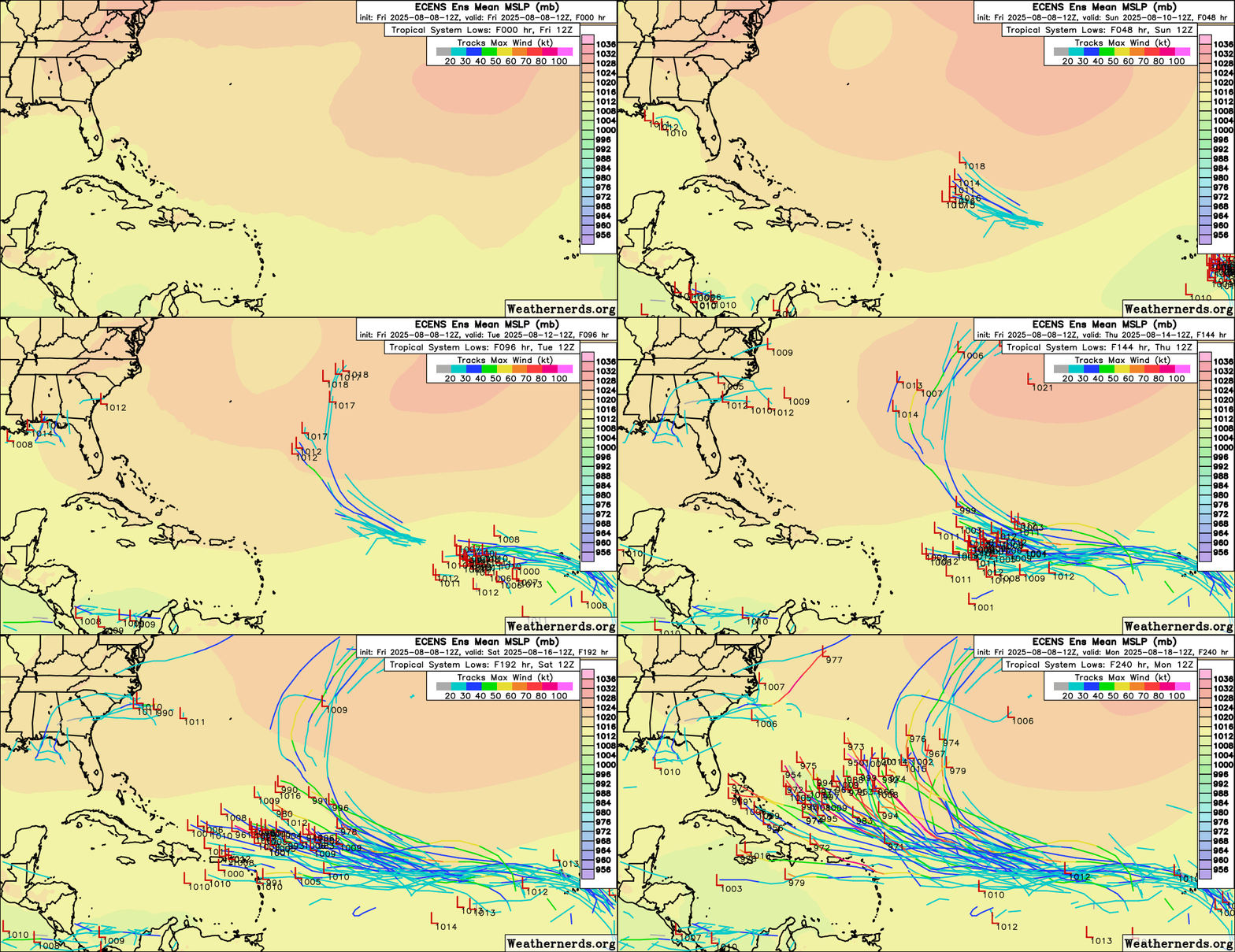
12Z Euro ensemble: many potential scenarios regarding the CONUS as would be expected this far out with many well offshore the E coast, some threatening the E coast, and 4 in/near the Gulf
1 likes   
Personal Forecast Disclaimer:
The posts in this forum are NOT official forecasts and should not be used as such. They are just the opinion of the poster and may or may not be backed by sound meteorological data. They are NOT endorsed by any professional institution or storm2k.org. For official information, please refer to the NHC and NWS products.

User avatar
ScottNAtlanta
Category 5
Category 5
Posts: 2404
Joined: Sat May 25, 2013 3:11 pm
Location: Atlanta, GA

Re: Tropical Wave Over West Africa

#123 Postby ScottNAtlanta » Fri Aug 08, 2025 1:51 pm

The GFS has a Rita like track
1 likes   
The posts in this forum are NOT official forecast and should not be used as such. They are just the opinion of the poster and may or may not be backed by sound meteorological data. They are NOT endorsed by any professional institution or storm2k.org. For official information, please refer to the NHC and NWS products.

Nederlander
S2K Supporter
S2K Supporter
Posts: 1251
Joined: Sat Jul 19, 2008 4:28 pm
Location: Conroe, TX

2025 Global Model Runs Discussion (Out thru day 16)

#124 Postby Nederlander » Fri Aug 08, 2025 1:56 pm

Image

12z GFS woke up and chose violence
6 likes   

Stormlover70
Tropical Storm
Tropical Storm
Posts: 183
Age: 55
Joined: Fri Jun 21, 2024 5:31 am
Location: New port richey

Re: 2025 Global Model Runs Discussion (Out thru day 16)

#125 Postby Stormlover70 » Fri Aug 08, 2025 2:00 pm

Nederlander wrote:https://i.ibb.co/dwNk9v2W/IMG-0033.png

12z GFS woke up and chose violence
full run?
1 likes   

Fancy1002
Tropical Storm
Tropical Storm
Posts: 159
Joined: Sun Dec 25, 2022 3:47 pm

Re: Tropical Wave Over West Africa

#126 Postby Fancy1002 » Fri Aug 08, 2025 2:05 pm

convergencezone2 wrote:
cycloneye wrote:The train. choo-choo. :D

 https://x.com/ZackFradellaWx/status/1953860739157860382


yep the trains have left the station for sure! 7 pages regarding a wave that hasn't even moved off the coast yet shows our thirst for the dopamine hits of development.

disclaimer: as thirsty as we are for activity, keep in mind, it reflects no desire to see death and destruction, because the weather is going to do what the weather is going to do. It's more about the excitement of watching storms come together.

I try to explain that to people, but they still think I’m crazy for getting excited over hurricanes.
5 likes   

User avatar
Jr0d
S2K Supporter
S2K Supporter
Posts: 1418
Joined: Tue Aug 27, 2019 10:52 am
Location: Cayo Hueso

Re: Tropical Wave Over West Africa

#127 Postby Jr0d » Fri Aug 08, 2025 2:06 pm


The GFS is living up to the Give Florida a Storm acronym.

Usually if we are in the bullseye in the early model runs, it won't hit. Irma was a rare exception to this rule of thumb.
4 likes   

User avatar
cycloneye
Admin
Admin
Posts: 145915
Age: 69
Joined: Thu Oct 10, 2002 10:54 am
Location: San Juan, Puerto Rico

Re: Tropical Wave Over West Africa

#128 Postby cycloneye » Fri Aug 08, 2025 2:08 pm

convergencezone2 wrote:
cycloneye wrote:The train. choo-choo. :D

 https://x.com/ZackFradellaWx/status/1953860739157860382


yep the trains have left the station for sure! 7 pages regarding a wave that hasn't even moved off the coast yet shows our thirst for the dopamine hits of development.

disclaimer: as thirsty as we are for activity, keep in mind, it reflects no desire to see death and destruction, because the weather is going to do what the weather is going to do. It's more about the excitement of watching storms come together.


I knew this wave would create plenty of discussions and that is why decided to make this thread separated from the main models discussion one.
3 likes   
Visit the Caribbean-Central America Weather Thread where you can find at first post web cams,radars
and observations from Caribbean basin members Click Here

User avatar
chris_fit
Category 5
Category 5
Posts: 3249
Age: 42
Joined: Wed Sep 10, 2003 11:58 pm
Location: Tampa Bay Area, FL

Re: 2025 Global Model Runs Discussion (Out thru day 16)

#129 Postby chris_fit » Fri Aug 08, 2025 2:08 pm

Stormlover70 wrote:
Nederlander wrote:https://i.ibb.co/dwNk9v2W/IMG-0033.png

12z GFS woke up and chose violence
full run?


Image
3 likes   

User avatar
chris_fit
Category 5
Category 5
Posts: 3249
Age: 42
Joined: Wed Sep 10, 2003 11:58 pm
Location: Tampa Bay Area, FL

Re: Tropical Wave Over West Africa

#130 Postby chris_fit » Fri Aug 08, 2025 2:10 pm

Jr0d wrote:


The GFS is living up to the Give Florida a Storm acronym.

Usually if we are in the bullseye in the early model runs, it won't hit. Irma was a rare exception to this rule of thumb.


GFS was pretty far out to sea when Irma was still in the E Atlantic (9+ days out) - To be fair, so was the Euro. Really started narrowing in only 5-6 days out.
3 likes   

Stormlover70
Tropical Storm
Tropical Storm
Posts: 183
Age: 55
Joined: Fri Jun 21, 2024 5:31 am
Location: New port richey

Re: 2025 Global Model Runs Discussion (Out thru day 16)

#131 Postby Stormlover70 » Fri Aug 08, 2025 2:26 pm

chris_fit wrote:
Stormlover70 wrote:
Nederlander wrote:https://i.ibb.co/dwNk9v2W/IMG-0033.png

12z GFS woke up and chose violence
full run?


https://i.imgur.com/0YAIMZY.gif
threading the. Needle between Cuba and Florida. :double:
1 likes   

User avatar
cycloneye
Admin
Admin
Posts: 145915
Age: 69
Joined: Thu Oct 10, 2002 10:54 am
Location: San Juan, Puerto Rico

Re: Tropical Wave Over West Africa

#132 Postby cycloneye » Fri Aug 08, 2025 2:28 pm

Irma's invest / TC thread had 622 pages and if all goes as both GFS and Euro have, the invest TC thread would get hundreds of pages. Let's see how things evolve in realtime.
9 likes   
Visit the Caribbean-Central America Weather Thread where you can find at first post web cams,radars
and observations from Caribbean basin members Click Here

User avatar
SouthFLTropics
Category 5
Category 5
Posts: 4239
Age: 50
Joined: Thu Aug 14, 2003 8:04 am
Location: Port St. Lucie, Florida

Re: 2025 Global Model Runs Discussion (Out thru day 16)

#133 Postby SouthFLTropics » Fri Aug 08, 2025 2:37 pm

Stormlover70 wrote:
chris_fit wrote:
Stormlover70 wrote:full run?


https://i.imgur.com/0YAIMZY.gif
threading the. Needle between Cuba and Florida. :double:


Key West would get rocked on that run. Big impacts to Cuba and Florida. Looks like Georges 1998 through the Keys and then Rita all the way to Texas.
0 likes   
Fourth Generation Florida Native

Personal Storm History: David 79, Andrew 92, Erin 95, Floyd 99, Irene 99, Frances 04, Jeanne 04, Wilma 05, Matthew 16, Irma 17, Ian 22, Nicole 22, Milton 24

User avatar
chris_fit
Category 5
Category 5
Posts: 3249
Age: 42
Joined: Wed Sep 10, 2003 11:58 pm
Location: Tampa Bay Area, FL

Re: Tropical Wave Over West Africa

#134 Postby chris_fit » Fri Aug 08, 2025 2:39 pm

cycloneye wrote:Irma's invest / TC thread had 622 pages and if all goes as both GFS and Euro have, the invest TC thread would get hundreds of pages. Let's see how things evolve in realtime.


Thanks for that - How I recall staying up late refreshing the pages to see the latest model runs. Was very nostalgic to go through that thread again.... In case you want to waste your time too: https://storm2k.org/phpbb2/viewtopic.ph ... 71df4546ac
0 likes   

BobHarlem
Category 5
Category 5
Posts: 2246
Joined: Thu Oct 20, 2005 6:11 pm

Re: Tropical Wave Over West Africa

#135 Postby BobHarlem » Fri Aug 08, 2025 3:01 pm

12z euro ensembles, a bit of a west shift from 0z.

Image
2 likes   

User avatar
Jr0d
S2K Supporter
S2K Supporter
Posts: 1418
Joined: Tue Aug 27, 2019 10:52 am
Location: Cayo Hueso

Re: Tropical Wave Over West Africa

#136 Postby Jr0d » Fri Aug 08, 2025 3:02 pm

chris_fit wrote:
Jr0d wrote:


The GFS is living up to the Give Florida a Storm acronym.

Usually if we are in the bullseye in the early model runs, it won't hit. Irma was a rare exception to this rule of thumb.


GFS was pretty far out to sea when Irma was still in the E Atlantic (9+ days out) - To be fair, so was the Euro. Really started narrowing in only 5-6 days out.


I might be mistaken then. Maybe I just remember getting rocked by her and my memory before impact is fuzzy.

I will have to look at old threads and hopefully remember which storm the GFS nailed a Florida hit 10 days out.
2 likes   

User avatar
Blown Away
S2K Supporter
S2K Supporter
Posts: 10162
Joined: Wed May 26, 2004 6:17 am

Re: Tropical Wave Over West Africa

#137 Postby Blown Away » Fri Aug 08, 2025 3:50 pm

Jr0d wrote:
chris_fit wrote:
Jr0d wrote:
The GFS is living up to the Give Florida a Storm acronym.

Usually if we are in the bullseye in the early model runs, it won't hit. Irma was a rare exception to this rule of thumb.


GFS was pretty far out to sea when Irma was still in the E Atlantic (9+ days out) - To be fair, so was the Euro. Really started narrowing in only 5-6 days out.


I might be mistaken then. Maybe I just remember getting rocked by her and my memory before impact is fuzzy.

I will have to look at old threads and hopefully remember which storm the GFS nailed a Florida hit 10 days out.


Yeah, that 12z run with MH due W over the Keys, no bueno!
1 likes   
Hurricane Eye Experience: David 79, Irene 99, Frances 04, Jeanne 04, Wilma 05… Hurricane Brush Experience: Andrew 92, Erin 95, Floyd 99, Matthew 16, Irma 17, Ian 22, Nicole 22…

JKG43
Tropical Wave
Tropical Wave
Posts: 4
Joined: Sat Aug 22, 2020 6:30 pm
Location: SE Texas Coast

Re: Tropical Wave Over West Africa

#138 Postby JKG43 » Fri Aug 08, 2025 4:26 pm

ScottNAtlanta wrote:The GFS has a Rita like track

And I just told a Rita story yesterday.
3 likes   

Pelicane
Tropical Storm
Tropical Storm
Posts: 106
Joined: Tue Sep 13, 2022 1:52 pm
Location: Lafayette, Louisiana

Re: Tropical Wave Over West Africa

#139 Postby Pelicane » Fri Aug 08, 2025 4:48 pm

18z GFS seems too aggressive. It thinks it'll close a LLC within 24 hours.
1 likes   

Ian2401
Category 1
Category 1
Posts: 319
Joined: Thu Sep 14, 2017 5:55 pm
Location: Tallahassee, Florida
Contact:

Re: Tropical Wave Near the West Coast of Africa

#140 Postby Ian2401 » Fri Aug 08, 2025 5:23 pm

18z GFS good bit north compared to 12z, but again it is probably organizing the storm way too quickly (within 24-36hrs!) especially considering how much SAL is just off the east coast of Africa. Also looks like meandering energy from 96L is a little more pronounced which matches its current satellite presentation and thus the ridge isn't able to build as much. Going to be hard to get as far west as 12z but we will see. Complex setup with a lot riding on how fast this storm can develop and how 96L evolves through the next few days.
0 likes   
B.S. Meteorology from Florida State '24 // Current M.S. Meteorology student at Florida State

Research Interests: Rapid Intensification, TC Climatology, TC Modeling

Consult the NHC for official information


Return to “Talkin' Tropics”

Who is online

Users browsing this forum: No registered users and 32 guests