ATL: ERIN - Tropical Storm - Discussion

Current storms and invests:

Moderators: hurricanetrack, S2k Moderators


The posts in this forum are NOT official forecasts and should not be used as such. They are just the opinion of the poster and may or may not be backed by sound meteorological data. They are NOT endorsed by any professional institution or STORM2K. For official information, please refer to products from the National Hurricane Center and National Weather Service.

Help Support Storm2K
Message
Author
TampaWxLurker
Tropical Storm
Tropical Storm
Posts: 121
Joined: Thu Aug 01, 2024 8:20 am

Re: ATL: INVEST 97L - Discussion

#81 Postby TampaWxLurker » Sun Aug 10, 2025 2:37 pm

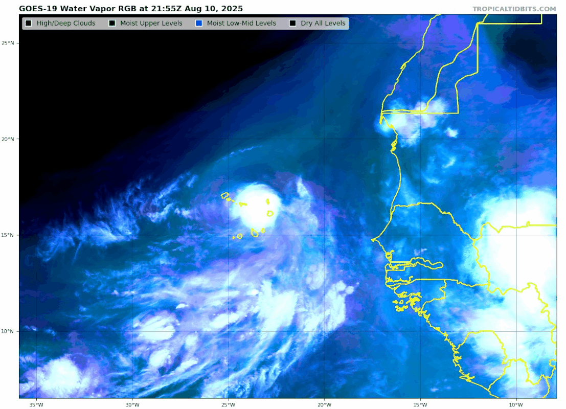
cycloneye wrote:18x Best Track: Is the 15.7N latitud is too high in terms of intensifying down the road?

AL, 97, 2025081018, , BEST, 0, 157N, 215W, 30, 1006, LO


https://i.imgur.com/YluClWx.png


That's some serious latitude for a system so far east. I know it's going to run into the ridge sooner rather than later, but here's to hoping it gets as absolutely far north as it can now before starting its trek west.
1 likes   

Cachondo23
Tropical Depression
Tropical Depression
Posts: 83
Joined: Wed May 25, 2022 5:56 am

Re: ATL: INVEST 97L - Discussion

#82 Postby Cachondo23 » Sun Aug 10, 2025 3:10 pm

Heavy rain fall in CV islands, specially in Boa Vista.
1 likes   

User avatar
cycloneye
Admin
Admin
Posts: 145870
Age: 69
Joined: Thu Oct 10, 2002 10:54 am
Location: San Juan, Puerto Rico

Re: ATL: INVEST 97L - Discussion

#83 Postby cycloneye » Sun Aug 10, 2025 3:50 pm

2 likes   
Visit the Caribbean-Central America Weather Thread where you can find at first post web cams,radars
and observations from Caribbean basin members Click Here

User avatar
ScottNAtlanta
Category 5
Category 5
Posts: 2400
Joined: Sat May 25, 2013 3:11 pm
Location: Atlanta, GA

ATL: INVEST 97L - Discussion

#84 Postby ScottNAtlanta » Sun Aug 10, 2025 4:40 pm

Nice blowup over the center
Image
4 likes   
The posts in this forum are NOT official forecast and should not be used as such. They are just the opinion of the poster and may or may not be backed by sound meteorological data. They are NOT endorsed by any professional institution or storm2k.org. For official information, please refer to the NHC and NWS products.

User avatar
cycloneye
Admin
Admin
Posts: 145870
Age: 69
Joined: Thu Oct 10, 2002 10:54 am
Location: San Juan, Puerto Rico

Re: ATL: INVEST 97L - Discussion

#85 Postby cycloneye » Sun Aug 10, 2025 5:05 pm

4 likes   
Visit the Caribbean-Central America Weather Thread where you can find at first post web cams,radars
and observations from Caribbean basin members Click Here

User avatar
storm_in_a_teacup
Category 1
Category 1
Posts: 427
Joined: Wed Aug 16, 2017 5:01 pm
Location: Huntsville, Alabama (originally from Houston)
Contact:

Re: ATL: INVEST 97L - Discussion

#86 Postby storm_in_a_teacup » Sun Aug 10, 2025 5:30 pm

This gonna be our first hurricane this year?
1 likes   
I know I can't straddle the atmosphere...just a tiny storm in your teacup, girl.

User avatar
StormWeather
Category 1
Category 1
Posts: 257
Joined: Wed Jun 05, 2024 2:34 pm

Re: ATL: INVEST 97L - Discussion

#87 Postby StormWeather » Sun Aug 10, 2025 5:31 pm

storm_in_a_teacup wrote:This gonna be our first hurricane this year?

It’s seeming very likely to be.
2 likes   
Just an average cyclone tracker

The posts in this forum are NOT official forecasts and should not be used as such. They are just the opinion of the poster and may or may not be backed by sound meteorological data. They are NOT endorsed by any professional institution or storm2k.org. For official information, please refer to the NHC and NWS products

User avatar
cycloneye
Admin
Admin
Posts: 145870
Age: 69
Joined: Thu Oct 10, 2002 10:54 am
Location: San Juan, Puerto Rico

Re: ATL: INVEST 97L - Discussion

#88 Postby cycloneye » Sun Aug 10, 2025 6:14 pm

Great video about Bermuda in the crosshairs from Fabian. Will it happen again with future Erin?

 https://x.com/ExtremeStorms/status/1954681666389385719

0 likes   
Visit the Caribbean-Central America Weather Thread where you can find at first post web cams,radars
and observations from Caribbean basin members Click Here

User avatar
eastcoastFL
Category 5
Category 5
Posts: 3906
Age: 43
Joined: Thu Apr 12, 2007 12:29 pm
Location: Palm City, FL

Re: ATL: INVEST 97L - Discussion

#89 Postby eastcoastFL » Sun Aug 10, 2025 6:23 pm

Quite persistent convection

Image
1 likes   
Personal Forecast Disclaimer:
The posts in this forum are NOT official forecast and should not be used as such. They are just the opinion of the poster and may or may not be backed by sound meteorological data. They are NOT endorsed by any professional institution or storm2k.org. For official information, please refer to the NHC and NWS products.

User avatar
eastcoastFL
Category 5
Category 5
Posts: 3906
Age: 43
Joined: Thu Apr 12, 2007 12:29 pm
Location: Palm City, FL

Re: ATL: INVEST 97L - Discussion

#90 Postby eastcoastFL » Sun Aug 10, 2025 6:24 pm

storm_in_a_teacup wrote:This gonna be our first hurricane this year?


It seems so.
0 likes   
Personal Forecast Disclaimer:
The posts in this forum are NOT official forecast and should not be used as such. They are just the opinion of the poster and may or may not be backed by sound meteorological data. They are NOT endorsed by any professional institution or storm2k.org. For official information, please refer to the NHC and NWS products.

User avatar
StormWeather
Category 1
Category 1
Posts: 257
Joined: Wed Jun 05, 2024 2:34 pm

Re: ATL: INVEST 97L - Discussion

#91 Postby StormWeather » Sun Aug 10, 2025 6:24 pm


This is likely a TC now or close to it. I expect TD Five or TS Erin at 11pm.
5 likes   
Just an average cyclone tracker

The posts in this forum are NOT official forecasts and should not be used as such. They are just the opinion of the poster and may or may not be backed by sound meteorological data. They are NOT endorsed by any professional institution or storm2k.org. For official information, please refer to the NHC and NWS products

User avatar
eastcoastFL
Category 5
Category 5
Posts: 3906
Age: 43
Joined: Thu Apr 12, 2007 12:29 pm
Location: Palm City, FL

Re: ATL: INVEST 97L - Discussion

#92 Postby eastcoastFL » Sun Aug 10, 2025 6:30 pm

Pretty good lightening going on right now also. Following the lightening it seems to be continuing wnw.

Image
1 likes   
Personal Forecast Disclaimer:
The posts in this forum are NOT official forecast and should not be used as such. They are just the opinion of the poster and may or may not be backed by sound meteorological data. They are NOT endorsed by any professional institution or storm2k.org. For official information, please refer to the NHC and NWS products.

User avatar
cycloneye
Admin
Admin
Posts: 145870
Age: 69
Joined: Thu Oct 10, 2002 10:54 am
Location: San Juan, Puerto Rico

Re: ATL: INVEST 97L - Discussion

#93 Postby cycloneye » Sun Aug 10, 2025 6:42 pm

Tropical Weather Outlook
NWS National Hurricane Center Miami FL
800 PM EDT Sun Aug 10 2025

For the North Atlantic...Caribbean Sea and the Gulf of America:

Eastern Tropical Atlantic (AL97):
Showers and thunderstorms continue to show signs of organization
in association with a well-defined low pressure area located over
the eastern portion of the Cabo Verde Islands. Only a small
increase in the organization could lead to the formation of a
tropical depression as the low continues moving across the Cabo
Verde Islands tonight and on Monday. Regardless of development,
locally heavy rainfall and gusty winds are expected to continue
tonight and Monday across the Cabo Verde Islands, and interests
there should monitor the progress of this system.

Even if a tropical depression does not form over the next day or so,
environmental conditions appear conducive for later development, and
a tropical depression or tropical storm is expected to form by the
middle to latter portion of this week while moving westward to
west-northwestward at 15 to 20 mph across the eastern and central
tropical Atlantic.
* Formation chance through 48 hours...medium...60 percent.
* Formation chance through 7 days...high...90 percent.
3 likes   
Visit the Caribbean-Central America Weather Thread where you can find at first post web cams,radars
and observations from Caribbean basin members Click Here

User avatar
HurricaneBelle
S2K Supporter
S2K Supporter
Posts: 1183
Joined: Sun Aug 27, 2006 6:12 pm
Location: Clearwater, FL

Re: ATL: INVEST 97L - Discussion

#94 Postby HurricaneBelle » Sun Aug 10, 2025 6:50 pm

NHC might normally have named it by now, but they're Erin on the side of caution.
21 likes   

User avatar
Jr0d
S2K Supporter
S2K Supporter
Posts: 1418
Joined: Tue Aug 27, 2019 10:52 am
Location: Cayo Hueso

Re: ATL: INVEST 97L - Discussion

#95 Postby Jr0d » Sun Aug 10, 2025 7:01 pm

It certainly has that mean look with intense convection we often see in the genesis stage of storms that become monsters.

It may take a WSW dive soon and it seems like storms that take that motion also often become monsters, it usually happens much further west. My guess as an amateur is when a storm takes that wsw or even sw dive, it is entering the eastern part of a high pressure ridge...and tropical systems thrive under those ridges.
8 likes   

User avatar
StormWeather
Category 1
Category 1
Posts: 257
Joined: Wed Jun 05, 2024 2:34 pm

Re: ATL: INVEST 97L - Discussion

#96 Postby StormWeather » Sun Aug 10, 2025 7:09 pm

HurricaneBelle wrote:NHC might normally have named it by now, but they're Erin on the side of caution.

Finally someone seeing the meme-worthiness of the name.

Though the name won’t be memeable here soon it seems.
0 likes   
Just an average cyclone tracker

The posts in this forum are NOT official forecasts and should not be used as such. They are just the opinion of the poster and may or may not be backed by sound meteorological data. They are NOT endorsed by any professional institution or storm2k.org. For official information, please refer to the NHC and NWS products

zzzh
Category 3
Category 3
Posts: 846
Joined: Thu Sep 02, 2021 1:13 pm

Re: ATL: INVEST 97L - Discussion

#97 Postby zzzh » Sun Aug 10, 2025 7:13 pm

2 likes   

BobHarlem
Category 5
Category 5
Posts: 2235
Joined: Thu Oct 20, 2005 6:11 pm

Re: ATL: INVEST 97L - Discussion

#98 Postby BobHarlem » Sun Aug 10, 2025 7:29 pm

Curious why they didn't at least do PTC on this, it's basically almost over the Cabo Verde now.
Image
1 likes   

User avatar
cycloneye
Admin
Admin
Posts: 145870
Age: 69
Joined: Thu Oct 10, 2002 10:54 am
Location: San Juan, Puerto Rico

Re: ATL: INVEST 97L - Discussion

#99 Postby cycloneye » Sun Aug 10, 2025 7:34 pm

4 likes   
Visit the Caribbean-Central America Weather Thread where you can find at first post web cams,radars
and observations from Caribbean basin members Click Here

User avatar
cycloneye
Admin
Admin
Posts: 145870
Age: 69
Joined: Thu Oct 10, 2002 10:54 am
Location: San Juan, Puerto Rico

Re: ATL: INVEST 97L - Discussion

#100 Postby cycloneye » Sun Aug 10, 2025 7:41 pm

00z Best Track now moving WNW.

AL, 97, 2025081100, , BEST, 0, 165N, 234W, 30, 1006, LO


Image
2 likes   
Visit the Caribbean-Central America Weather Thread where you can find at first post web cams,radars
and observations from Caribbean basin members Click Here


Return to “Active Storms/Invests - Atlantic/EastPAC/CentralPAC/MED”

Who is online

Users browsing this forum: Google Adsense [Bot], redingtonbeach, StormWeather and 96 guests