ATL: ERIN - Tropical Storm - Discussion

Current storms and invests:

Moderators: hurricanetrack, S2k Moderators


The posts in this forum are NOT official forecasts and should not be used as such. They are just the opinion of the poster and may or may not be backed by sound meteorological data. They are NOT endorsed by any professional institution or STORM2K. For official information, please refer to products from the National Hurricane Center and National Weather Service.

Help Support Storm2K
Message
Author
User avatar
GCANE
S2K Supporter
S2K Supporter
Posts: 11518
Joined: Mon Oct 22, 2007 8:03 am

Re: ATL: ERIN - Tropical Storm - Discussion

#181 Postby GCANE » Tue Aug 12, 2025 6:05 am

Two low-level vorts are associated with this system. Erin west of the CV islands and a weaker vort just south of the islands. This creates a Fujiwhara effect imparting a counter-clockwise force on Erin. Thus the shift in forecast track. Need to watch how this evolves.

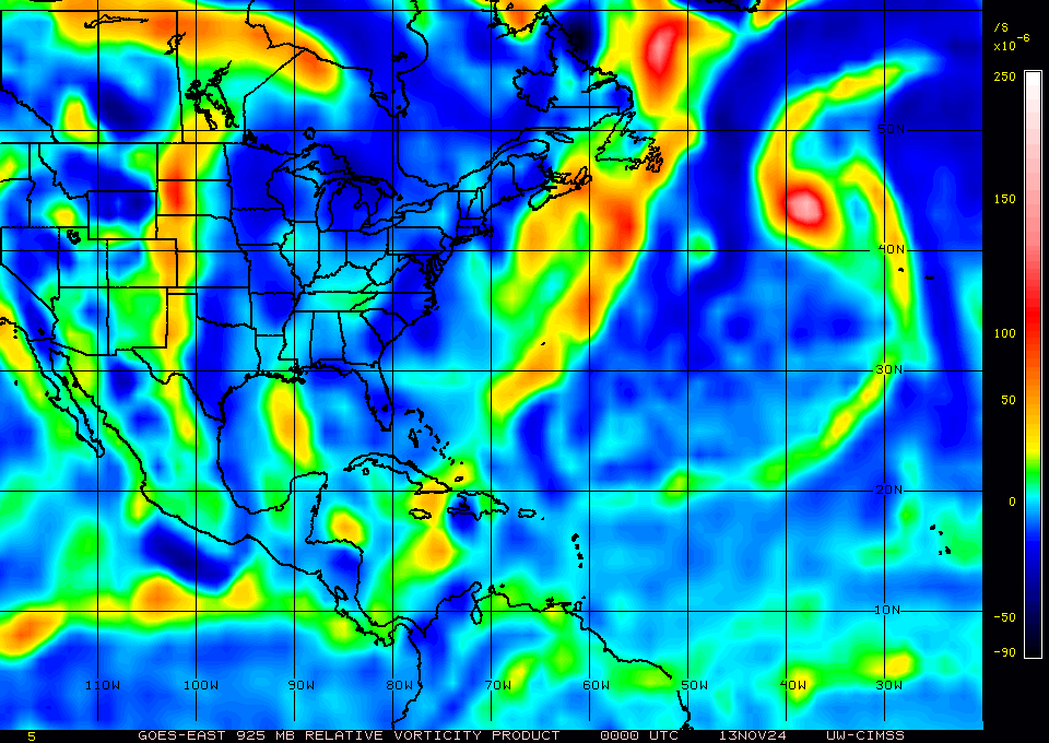
SAL is also very strong all the way to the islands, which will limit development of Erin.

IMHO, we should see future forecast track shifts to a more westerly track and Erin may impact the islands.


Image

Image
1 likes   

User avatar
Nimbus
Category 5
Category 5
Posts: 5332
Joined: Mon Jul 19, 2004 10:54 am

Re: ATL: ERIN - Tropical Storm - Discussion

#182 Postby Nimbus » Tue Aug 12, 2025 6:09 am


Erin has a small core which may win the battle against the SAL as she gets over warmer SST's.
In the mean time it looks like the track will be weak and west which is not a good trend for the islands.
And the new AI forecast runs are showing different ridging than earlier so that AI hype is still garbage in garbage out.

Felt good for a few days to see Erins track rounding the bend OTS inside Bermuda though.
1 likes   

User avatar
GCANE
S2K Supporter
S2K Supporter
Posts: 11518
Joined: Mon Oct 22, 2007 8:03 am

Re: ATL: ERIN - Tropical Storm - Discussion

#183 Postby GCANE » Tue Aug 12, 2025 6:13 am

The east vort currently has much stronger convection associated with it than Erin.
0 likes   

User avatar
GCANE
S2K Supporter
S2K Supporter
Posts: 11518
Joined: Mon Oct 22, 2007 8:03 am

Re: ATL: ERIN - Tropical Storm - Discussion

#184 Postby GCANE » Tue Aug 12, 2025 6:22 am

It appears Erin is more a product of LL TPW forcing. This may get pinched off in a couple days.
IMHO the east LL vort has a chance to take over.

https://tropic.ssec.wisc.edu/real-time/ ... anim=html5
0 likes   

User avatar
GCANE
S2K Supporter
S2K Supporter
Posts: 11518
Joined: Mon Oct 22, 2007 8:03 am

Re: ATL: ERIN - Tropical Storm - Discussion

#185 Postby GCANE » Tue Aug 12, 2025 6:28 am

GFS does show the TPW forcing being pinched off when Erin hits 50W.
Also, not a lot of inflow from the Amazon until 65W.

Virgin Islands and Puerto Rico needs to keep a close eye on this.
0 likes   

User avatar
Blown Away
S2K Supporter
S2K Supporter
Posts: 10162
Joined: Wed May 26, 2004 6:17 am

Re: ATL: ERIN - Tropical Storm - Discussion

#186 Postby Blown Away » Tue Aug 12, 2025 7:06 am

Image
LLC naked, but well formed and maybe moving WSW now.
1 likes   
Hurricane Eye Experience: David 79, Irene 99, Frances 04, Jeanne 04, Wilma 05… Hurricane Brush Experience: Andrew 92, Erin 95, Floyd 99, Matthew 16, Irma 17, Ian 22, Nicole 22…

LarryWx
S2K Supporter
S2K Supporter
Posts: 6409
Joined: Sun Sep 07, 2003 2:04 pm
Location: GA

Re: ATL: ERIN - Tropical Storm - Discussion

#187 Postby LarryWx » Tue Aug 12, 2025 7:36 am

LarryWx wrote:
cycloneye wrote:Tuesday will be a important day to see how far down in latitude, the circulation goes.


The good news in the short-term for the US is that Erin climbed slightly from 17.4N to 17.6N (275 degree heading) since the previous advisory vs a prog to stay at 17.4N (270 degree heading). Could be a good sign regarding keeping the latitude instead of losing much. We’ll see!


Followup to above: Per the 5AM advisory, Erin dropped back down slightly from 17.6N to 17.4N with a 265 degree heading. The new track has a low point of 17.0N tomorrow instead of 17.1N. The 17.0N will be a key latitudinal benchmark to compare to tomorrow.
1 likes   
Personal Forecast Disclaimer:
The posts in this forum are NOT official forecasts and should not be used as such. They are just the opinion of the poster and may or may not be backed by sound meteorological data. They are NOT endorsed by any professional institution or storm2k.org. For official information, please refer to the NHC and NWS products.

TomballEd
Category 2
Category 2
Posts: 792
Age: 61
Joined: Wed Aug 16, 2023 4:52 pm
Location: Spring/Klein area, not Tomball

Re: ATL: ERIN - Tropical Storm - Discussion

#188 Postby TomballEd » Tue Aug 12, 2025 7:36 am

The one thing about saying models are missing the weaker vorticity back by the CVs is implying the models aren't initialized with satellite derived products. CIMMS is satellite products for academic and public consumption.

It will be interesting if the runs a bit further S/W, passage closer to the NE Caribbean and Carolinas, is windshield wiping or a trend. If it keeps creeping, it is a trend and 'the trend is your friend.

Other thing is comparing models to actual Erin satellite, coldest cloud tops now only -50C, if Erin becomes a shallow naked swirl it should get farther W.
1 likes   

User avatar
cycloneye
Admin
Admin
Posts: 145918
Age: 69
Joined: Thu Oct 10, 2002 10:54 am
Location: San Juan, Puerto Rico

Re: ATL: ERIN - Tropical Storm - Discussion

#189 Postby cycloneye » Tue Aug 12, 2025 7:46 am

12z Best Track down to 35 kt.

AL, 05, 2025081212, , BEST, 0, 173N, 354W, 35, 1005, TS


Image
0 likes   
Visit the Caribbean-Central America Weather Thread where you can find at first post web cams,radars
and observations from Caribbean basin members Click Here

AutoPenalti
Category 5
Category 5
Posts: 4047
Age: 29
Joined: Mon Aug 17, 2015 4:16 pm
Location: Ft. Lauderdale, Florida

Re: ATL: ERIN - Tropical Storm - Discussion update= 12z Best Track down to 35 kt

#190 Postby AutoPenalti » Tue Aug 12, 2025 7:52 am

Moving WSW now.
0 likes   
The posts in this forum are NOT official forecasts and should not be used as such. They are just the opinion of the poster and may or may not be backed by sound meteorological data. They are NOT endorsed by any professional institution or STORM2K. For official information, please refer to products from the NHC and NWS.


Model Runs Cheat Sheet:
GFS (5:30 AM/PM, 11:30 AM/PM)
HWRF, GFDL, UKMET, NAVGEM (6:30-8:00 AM/PM, 12:30-2:00 AM/PM)
ECMWF (1:45 AM/PM)

TCVN
is a weighted averaged

User avatar
ColdMiser123
Professional-Met
Professional-Met
Posts: 905
Age: 29
Joined: Mon Sep 26, 2016 3:26 pm
Location: Northeast US

Re: ATL: ERIN - Tropical Storm - Discussion update= 12z Best Track down to 35 kt

#191 Postby ColdMiser123 » Tue Aug 12, 2025 7:54 am

Personally have lower confidence than normal on track, since it will be dependent on intensity. The weaker this remains for a longer amount of time, the farther west it will likely get. The flip side is also true. How much Erin continues to deal with dry air limiting its intensity in the short to medium term will be key.
6 likes   
B.S., M.S., Meteorology & Atmospheric Science

User avatar
wxman57
Moderator-Pro Met
Moderator-Pro Met
Posts: 22995
Age: 67
Joined: Sat Jun 21, 2003 8:06 pm
Location: Houston, TX (southwest)

Re: ATL: ERIN - Tropical Storm - Discussion update= 12z Best Track down to 35 kt

#192 Postby wxman57 » Tue Aug 12, 2025 8:18 am

Look for the NHC to adjust their track in the 3-5 day time frame farther south. They're about 1.5 degrees north of consensus now. Fast storms almost always track farther south than predicted. I have the track passing 60W well south of 20N, taking TS wind to the northern islands, including San Juan. It should turn north after passing the eastern Caribbean, staying well off the U.S. coast. However, it will look very scary, as I think it's heading for Cat 4 by next Mon/Tue.
18 likes   

Cachondo23
Tropical Depression
Tropical Depression
Posts: 87
Joined: Wed May 25, 2022 5:56 am

Re: ATL: ERIN - Tropical Storm - Discussion update= 12z Best Track down to 35 kt

#193 Postby Cachondo23 » Tue Aug 12, 2025 8:35 am

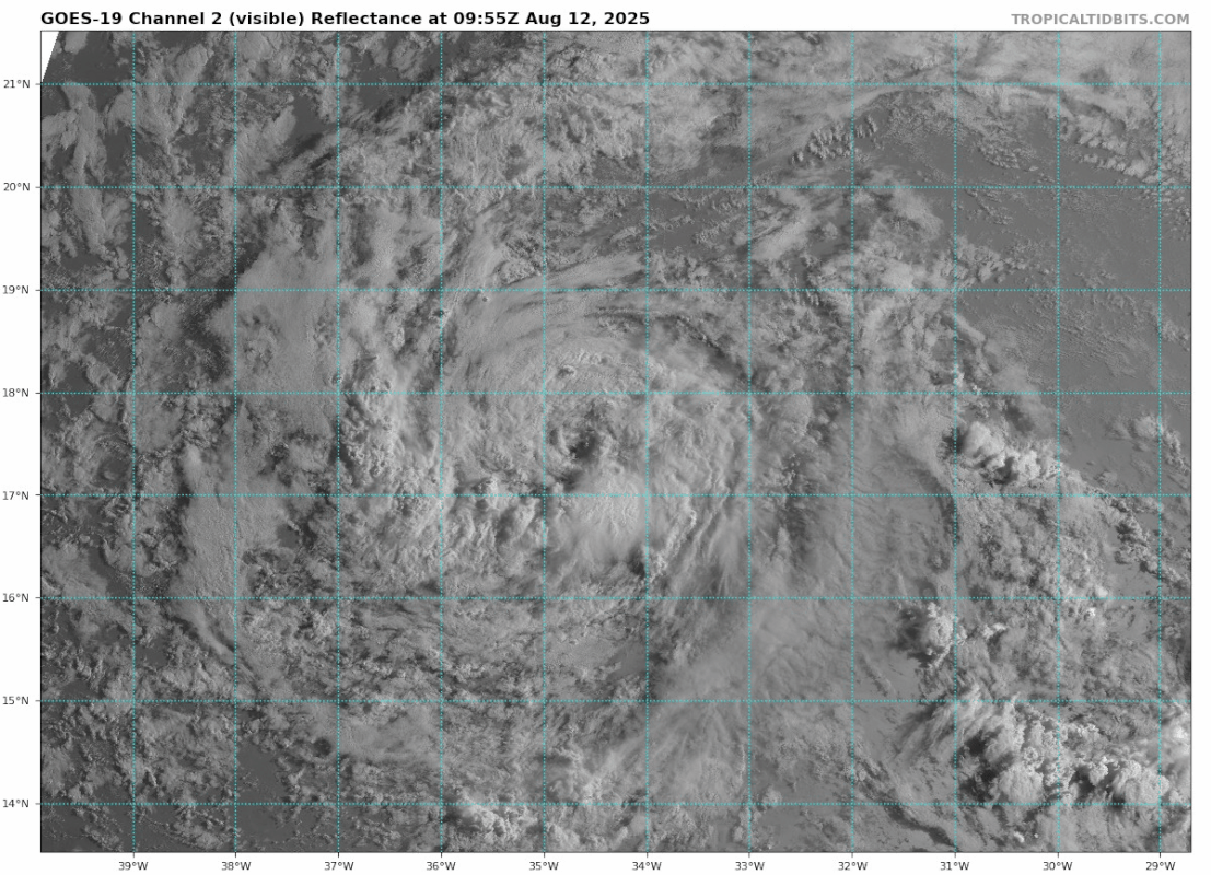
wxman57 wrote:Look for the NHC to adjust their track in the 3-5 day time frame farther south. They're about 1.5 degrees north of consensus now. Fast storms almost always track farther south than predicted. I have the track passing 60W well south of 20N, taking TS wind to the northern islands, including San Juan. It should turn north after passing the eastern Caribbean, staying well off the U.S. coast. However, it will look very scary, as I think it's heading for Cat 4 by next Mon/Tue.

TS winds in San Juan? Interesting, I would expect the worst part of the storm to the north of the Islands like it normally occurs with systems passing just north of NE Caribbean Islands.
0 likes   

User avatar
msbee
S2K Supporter
S2K Supporter
Posts: 3029
Joined: Wed Jun 11, 2003 10:11 am
Location: St. Maarten

Re: ATL: ERIN - Tropical Storm - Discussion

#194 Postby msbee » Tue Aug 12, 2025 8:39 am

cycloneye wrote:From the 5 AM discussion:

The official forecast track is a little left, or
south, of the previous one in 3-5 days, and very close to the
latest dynamical model consensus. This also very similar to the
mean of the GFS and ECMWF solutions.


https://i.imgur.com/CLSzzMt.png


watching this very carefully here in the NE Caribbean. I have too often been surprised by storms coming at us in unexpected ways. :roll:
0 likes   
Too many hurricanes to remember

Keldeo1997
Category 2
Category 2
Posts: 651
Joined: Fri Oct 11, 2019 11:35 pm

Re: ATL: ERIN - Tropical Storm - Discussion update= 12z Best Track down to 35 kt

#195 Postby Keldeo1997 » Tue Aug 12, 2025 8:41 am

Is there a chance that it gets so far south that it runs into the shredder, stays too weak that it misses the weakness and gets into the gulf?
0 likes   

WeatherBoy2000
Category 1
Category 1
Posts: 377
Joined: Mon Apr 10, 2023 9:29 am

Re: ATL: ERIN - Tropical Storm - Discussion update= 12z Best Track down to 35 kt

#196 Postby WeatherBoy2000 » Tue Aug 12, 2025 8:47 am

Keldeo1997 wrote:Is there a chance that it gets so far south that it runs into the shredder, stays too weak that it misses the weakness and gets into the gulf?


There's always a chance, but there's pretty much no model or ensemble support for this happening.
1 likes   

MEANINGLESS_NUMBERS
Category 1
Category 1
Posts: 341
Joined: Mon Nov 02, 2020 1:43 pm

Re: ATL: ERIN - Tropical Storm - Discussion update= 12z Best Track down to 35 kt

#197 Postby MEANINGLESS_NUMBERS » Tue Aug 12, 2025 9:04 am

Keldeo1997 wrote:Is there a chance that it gets so far south that it runs into the shredder, stays too weak that it misses the weakness and gets into the gulf?


No reason to think this
0 likes   
Emily '87, Felix '95, Gert '99, Fabian '03, Humberto '19, Paulette '20, Teddy '20, Fiona '22, Lee '23, Ernesto '24

User avatar
cycloneye
Admin
Admin
Posts: 145918
Age: 69
Joined: Thu Oct 10, 2002 10:54 am
Location: San Juan, Puerto Rico

Re: ATL: ERIN - Tropical Storm - Discussion

#198 Postby cycloneye » Tue Aug 12, 2025 9:05 am

0 likes   
Visit the Caribbean-Central America Weather Thread where you can find at first post web cams,radars
and observations from Caribbean basin members Click Here

AutoPenalti
Category 5
Category 5
Posts: 4047
Age: 29
Joined: Mon Aug 17, 2015 4:16 pm
Location: Ft. Lauderdale, Florida

Re: ATL: ERIN - Tropical Storm - Discussion update= 12z Best Track down to 35 kt

#199 Postby AutoPenalti » Tue Aug 12, 2025 9:24 am

MEANINGLESS_NUMBERS wrote:
Keldeo1997 wrote:Is there a chance that it gets so far south that it runs into the shredder, stays too weak that it misses the weakness and gets into the gulf?


No reason to think this

I wouldn't say that, it really just depends how far South it gets under the lower level steering flow.
0 likes   
The posts in this forum are NOT official forecasts and should not be used as such. They are just the opinion of the poster and may or may not be backed by sound meteorological data. They are NOT endorsed by any professional institution or STORM2K. For official information, please refer to products from the NHC and NWS.


Model Runs Cheat Sheet:
GFS (5:30 AM/PM, 11:30 AM/PM)
HWRF, GFDL, UKMET, NAVGEM (6:30-8:00 AM/PM, 12:30-2:00 AM/PM)
ECMWF (1:45 AM/PM)

TCVN
is a weighted averaged

User avatar
kevin
Category 5
Category 5
Posts: 2604
Age: 26
Joined: Wed Aug 28, 2019 4:35 am

Re: ATL: ERIN - Tropical Storm - Discussion

#200 Postby kevin » Tue Aug 12, 2025 9:27 am

Based on the latest ARCHER fix at 12:40pm UTC Erin has started a more distinct WSW motion of 260 degrees (compared to ~266 deg 6 hours ago). The ARCHER fix puts it at 17.20N two hours ago, which was about 0.1 deg south of the forecast track. Still too small deviations to draw conclusions from, but it's worth keeping an eye on the coming hours/day.
3 likes   


Return to “Active Storms/Invests - Atlantic/EastPAC/CentralPAC/MED”

Who is online

Users browsing this forum: Okibeach and 74 guests