
ATL: ERIN - Post-Tropical - Discussion
Moderator: S2k Moderators
-
WaveBreaking

- Category 2

- Posts: 722
- Joined: Sun Jun 30, 2024 11:33 am
- Location: US
Re: ATL: ERIN - Tropical Storm - Discussion
Sunset
5 likes
I am NOT a professional meteorologist, so take all of my posts with a grain of salt. My opinions are mine and mine alone.
-
WaveBreaking
- Category 2
- Posts: 722
- Joined: Sun Jun 30, 2024 11:33 am
- Location: US
Re: ATL: ERIN - Tropical Storm - Discussion
Also here's a "true" color image of Erin I made using the red, green, and blue visible GOES channels. I think it came out pretty good looking.

13 likes
I am NOT a professional meteorologist, so take all of my posts with a grain of salt. My opinions are mine and mine alone.
-
jconsor
- Professional-Met

- Posts: 580
- Joined: Mon Jun 30, 2008 9:31 pm
- Location: Jerusalem, Israel
- Contact:
Re: ATL: ERIN - Tropical Storm - Discussion
Tropical Storm #Erin continues trucking west and is showing signs of life after nearly two days of struggling. While a weakness in the western Atlantic ridge is a given, how quickly the ridge rebounds and what role an eastern US trough play could lead to some longer-term track intrigue.
Check out the full in-depth analysis and a parody of a 1970s R&B classic here: https://hurricanehacker.substack.com/p/losin-latitude
Check out the full in-depth analysis and a parody of a 1970s R&B classic here: https://hurricanehacker.substack.com/p/losin-latitude
5 likes
-
ScottNAtlanta

- Category 5

- Posts: 2535
- Joined: Sat May 25, 2013 3:11 pm
- Location: Atlanta, GA
Re: ATL: ERIN - Tropical Storm - Discussion
It still looks to me like it is south of due west. The longer this loses latitude the more you can bet we will see track changes.
3 likes
The posts in this forum are NOT official forecast and should not be used as such. They are just the opinion of the poster and may or may not be backed by sound meteorological data. They are NOT endorsed by any professional institution or storm2k.org. For official information, please refer to the NHC and NWS products.
-
Kingarabian

- S2K Supporter

- Posts: 16364
- Joined: Sat Aug 08, 2009 3:06 am
- Location: Honolulu, Hawaii
Re: ATL: ERIN - Tropical Storm - Discussion
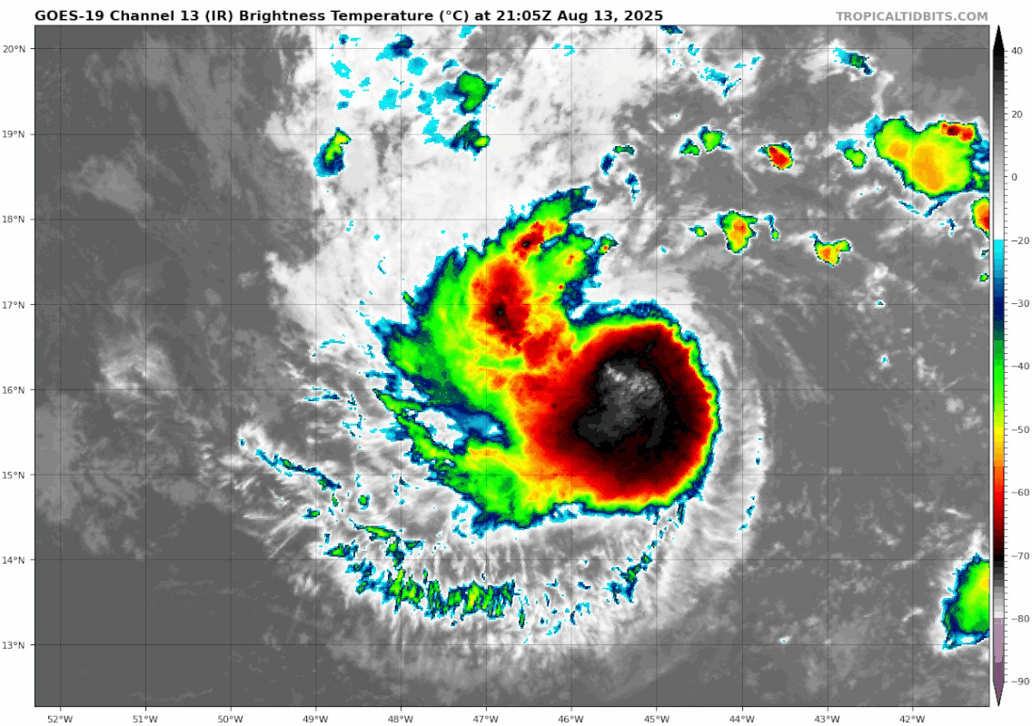
Convective canopy has dipped below 16N. Not sure if the LLC is sitting just north of the convection.
4 likes
RIP Kobe Bryant
-
Coolcruiseman
- Tropical Depression

- Posts: 97
- Age: 52
- Joined: Wed Sep 21, 2022 8:10 pm
- Location: Melbourne, FL
Re: ATL: ERIN - Tropical Storm - Discussion
ScottNAtlanta wrote:It still looks to me like it is south of due west. The longer this loses latitude the more you can bet we will see track changes.
All the more reason to keep focusing on trends. As the saying goes timing is everything in regards to the forecasted weakness.
Also why I’m not sold on the recurve even though it appears likely at this point.
1 likes
-
cycloneye

- Admin

- Posts: 149464
- Age: 69
- Joined: Thu Oct 10, 2002 10:54 am
- Location: San Juan, Puerto Rico
Re: ATL: ERIN - Tropical Storm - Discussion
Kingarabian wrote:Convective canopy has dipped below 16N. Not sure if the LLC is sitting just north of the convection.
Let's see if there will be an ASCAT pass over the storm to see in reallity, where is the circulation.
2 likes
Visit the Caribbean-Central America Weather Thread where you can find at first post web cams,radars
and observations from Caribbean basin members Click Here
and observations from Caribbean basin members Click Here
Re: ATL: ERIN - Tropical Storm - Discussion

Looks pretty good. Need microwave to see what's under the hood.
10 likes
-
cycloneye
- Admin
- Posts: 149464
- Age: 69
- Joined: Thu Oct 10, 2002 10:54 am
- Location: San Juan, Puerto Rico
Re: ATL: ERIN - Tropical Storm - Discussion
TXNT25 KNES 140017
TCSNTL
A. 05L (ERIN)
B. 14/0000Z
C. 16.2N
D. 46.0W
E. THREE/GOES-E
F. T3.0/3.0
G. IR/EIR/PRXY/VIS/SSMIS
H. REMARKS...6/10 BANDING RESULTS IN A DT OF 3.0. LGT NE SHEAR IMPACTING
SYSTEM. UPR-LVL OUTFLOW BECMG MORE DEFINED S AND SW QUADS. MET=2.5 AND
PT=3.0. FT BASED ON PT DUE TO PULSING CONVECTION AND BANDING NOT CLR-CUT.
I. ADDL POSITIONS
13/1837Z 16.3N 44.5W SSMIS
1 likes
Visit the Caribbean-Central America Weather Thread where you can find at first post web cams,radars
and observations from Caribbean basin members Click Here
and observations from Caribbean basin members Click Here
-
cycloneye
- Admin
- Posts: 149464
- Age: 69
- Joined: Thu Oct 10, 2002 10:54 am
- Location: San Juan, Puerto Rico
Re: ATL: ERIN - Tropical Storm - Discussion
00z Best Track. Moving west at 270 degrees.

AL, 05, 2025081400, , BEST, 0, 163N, 459W, 45, 1002, TS
1 likes
Visit the Caribbean-Central America Weather Thread where you can find at first post web cams,radars
and observations from Caribbean basin members Click Here
and observations from Caribbean basin members Click Here

Re: ATL: ERIN - Tropical Storm - Discussion
Why do I feel that Erin is heading right for me?

5 likes
Too many hurricanes to remember
-
cycloneye
- Admin
- Posts: 149464
- Age: 69
- Joined: Thu Oct 10, 2002 10:54 am
- Location: San Juan, Puerto Rico
Re: ATL: ERIN - Tropical Storm - Discussion
msbee wrote:Why do I feel that Erin is heading right for me?
Dont feel that way Barbara. All the models have Erin passing north of St Marteen and you will have some indirect effects such as some rainbands with gusty winds and the surf will be very high.
3 likes
Visit the Caribbean-Central America Weather Thread where you can find at first post web cams,radars
and observations from Caribbean basin members Click Here
and observations from Caribbean basin members Click Here
Re: ATL: ERIN - Tropical Storm - Discussion
cycloneye wrote:msbee wrote:Why do I feel that Erin is heading right for me?
Dont feel that way Barbara. All the models have Erin passing north of St Marteen and you will have some indirect effects such as some rainbands with gusty winds and the surf will be very high.
Hi Luis. Yes, that is what we’re expecting here. I know we all will be ok but I won’t feel totally confident until I see her making that north turn.
Thanks for all your updates.
2 likes
Too many hurricanes to remember
-
Hurricane2022

- Category 5
- Posts: 2037
- Joined: Tue Aug 23, 2022 11:38 pm
- Location: Araçatuba, Brazil
Re: ATL: ERIN - Tropical Storm - Discussion
3 likes
Sorry for the bad English sometimes...!
For reliable and detailed information for any meteorological phenomenon, please consult the National Hurricane Center, Joint Typhoon Warning Center , or your local Meteo Center.
--------
ECCE OMNIA NOVA FACIAM (Ap 21,5).
For reliable and detailed information for any meteorological phenomenon, please consult the National Hurricane Center, Joint Typhoon Warning Center , or your local Meteo Center.
--------
ECCE OMNIA NOVA FACIAM (Ap 21,5).

Re: ATL: ERIN - Tropical Storm - Discussion
Looking pretty good.
5 likes
TC naming lists: retirements and intensity
Most aggressive Advisory #1's in North Atlantic (cr. kevin for starting the list)
Most aggressive Advisory #1's in North Atlantic (cr. kevin for starting the list)

-
cycloneye
- Admin
- Posts: 149464
- Age: 69
- Joined: Thu Oct 10, 2002 10:54 am
- Location: San Juan, Puerto Rico
Re: ATL: ERIN - Tropical Storm - Discussion
NHC did not moved the forecast track as it is the same as the 5 PM one.

1 likes
Visit the Caribbean-Central America Weather Thread where you can find at first post web cams,radars
and observations from Caribbean basin members Click Here
and observations from Caribbean basin members Click Here
Re: ATL: ERIN - Tropical Storm - Discussion
cycloneye wrote:NHC did not moved the forecast track as it is the same as the 5 PM one.
https://i.imgur.com/3GZC1ao.png
Note that with the time frame moving up, the new peak at the end of the forecast (120 hrs) is 110 kt, almost Cat 4.
3 likes
TC naming lists: retirements and intensity
Most aggressive Advisory #1's in North Atlantic (cr. kevin for starting the list)
Most aggressive Advisory #1's in North Atlantic (cr. kevin for starting the list)
Re: ATL: ERIN - Tropical Storm - Discussion

Disagree with NHC's position estimate. Scatterometer clearly shows that the center is at 16N.
4 likes
-
ScottNAtlanta
- Category 5
- Posts: 2535
- Joined: Sat May 25, 2013 3:11 pm
- Location: Atlanta, GA
Re: ATL: ERIN - Tropical Storm - Discussion
zzzh wrote:https://i.imgur.com/pfbeVTr.png
Disagree with NHC's position estimate. Scatterometer clearly shows that the center is at 16N
Something I just noticed on the Univ of Wisconsin site is that when you look at vorticity from 925 up to 700, it is south of where Erin is indicated to be. Do they get that position from NHC? If they do, it doesn't pan out with where all the vorticity is. That vorticity to the east might be adding an unknown as well.

Last edited by ScottNAtlanta on Wed Aug 13, 2025 10:10 pm, edited 1 time in total.
1 likes
The posts in this forum are NOT official forecast and should not be used as such. They are just the opinion of the poster and may or may not be backed by sound meteorological data. They are NOT endorsed by any professional institution or storm2k.org. For official information, please refer to the NHC and NWS products.
Who is online
Users browsing this forum: No registered users and 13 guests