AL, 98, 2025081318, , BEST, 0, 184N, 899W, 20, 1012, DB, 34, NEQ, 0, 0, 0, 0, 1015, 150, 100, 0, 0, L, 0, , 0, 0, INVEST, S, 0, , 0, 0, 0, 0, genesis-num, 017, SPAWNINVEST, al772025 to al982025,
ATL: INVEST 98L - Discussion
Moderator: S2k Moderators
-
ScottNAtlanta

- Category 5

- Posts: 2535
- Joined: Sat May 25, 2013 3:11 pm
- Location: Atlanta, GA
Re: ATL: INVEST 98L - Discussion
Wow, so they tagged this one.
1 likes
The posts in this forum are NOT official forecast and should not be used as such. They are just the opinion of the poster and may or may not be backed by sound meteorological data. They are NOT endorsed by any professional institution or storm2k.org. For official information, please refer to the NHC and NWS products.

Re: ATL: INVEST 98L - Discussion
ScottNAtlanta wrote:Wow, so they tagged this one.
Probably cuz it’s close to land.
1 likes
-
Stratton23
- Category 5
- Posts: 3598
- Joined: Fri Jul 21, 2023 10:59 pm
- Location: Katy, Tx
Re: ATL: INVEST 98L - Discussion
New flare up of convection well to the North of where they have 98L “ center” with the X, if you wanna call it that , im impressed its managed to hold together pretty well over the yucatan
1 likes
-
cycloneye

- Admin

- Posts: 149846
- Age: 69
- Joined: Thu Oct 10, 2002 10:54 am
- Location: San Juan, Puerto Rico
Re: ATL: INVEST 98L - Discussion
Tropical Weather Outlook
NWS National Hurricane Center Miami FL
800 PM EDT Wed Aug 13 2025
For the North Atlantic...Caribbean Sea and the Gulf of America:
Active Systems:
The National Hurricane Center is issuing advisories on Tropical
Storm Erin, located over the central tropical Atlantic.
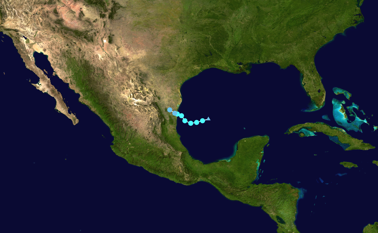
Southwestern Gulf (AL98):
A broad low pressure area has formed from a tropical wave over the
Yucatan Peninsula with disorganized shower and thunderstorm
activity. This low is forecast to move west-northwestward across
the southwestern Gulf overnight where environmental conditions are
marginally conducive for further development. The system is
forecast to move inland over northeastern Mexico by late Friday,
ending its chances of formation.
* Formation chance through 48 hours...low...20 percent.
* Formation chance through 7 days...low...20 percent.
$$
Forecaster Blake
NWS National Hurricane Center Miami FL
800 PM EDT Wed Aug 13 2025
For the North Atlantic...Caribbean Sea and the Gulf of America:
Active Systems:
The National Hurricane Center is issuing advisories on Tropical
Storm Erin, located over the central tropical Atlantic.
Southwestern Gulf (AL98):
A broad low pressure area has formed from a tropical wave over the
Yucatan Peninsula with disorganized shower and thunderstorm
activity. This low is forecast to move west-northwestward across
the southwestern Gulf overnight where environmental conditions are
marginally conducive for further development. The system is
forecast to move inland over northeastern Mexico by late Friday,
ending its chances of formation.
* Formation chance through 48 hours...low...20 percent.
* Formation chance through 7 days...low...20 percent.
$$
Forecaster Blake
0 likes
Visit the Caribbean-Central America Weather Thread where you can find at first post web cams,radars
and observations from Caribbean basin members Click Here
and observations from Caribbean basin members Click Here

Re: ATL: INVEST 98L - Discussion
IF 98L becomes Fernand - and that's a big if - it would be eerily reminiscent of the last iteration of the same name, just 20 days earlier:
2 likes
TC naming lists: retirements and intensity
Most aggressive Advisory #1's in North Atlantic (cr. kevin for starting the list)
Most aggressive Advisory #1's in North Atlantic (cr. kevin for starting the list)
Re: ATL: INVEST 98L - Discussion
Teban54 wrote:IF 98L becomes Fernand - and that's a big if - it would be eerily reminiscent of the last iteration of the same name, just 20 days earlier:
https://i.postimg.cc/3N9nKNkL/image.png
Not only that, the 2013 iteration also formed in the same general area before making landfall in Mexico as a short-lived TS. In fact, since Fernand was first used in 2013 (after replacing Felix), every iteration of Fernand has formed in this area of the Gulf/Bay of Campeche before moving NW into Mexico. Part of me kind of wants 98L to be named just to keep this insane coincidence going - maybe I'm just not thinking of one, but I don't think we've had a name that has ended up doing pretty much the exact same thing 3+ consecutive times in a row
9 likes
-
cycloneye
- Admin
- Posts: 149846
- Age: 69
- Joined: Thu Oct 10, 2002 10:54 am
- Location: San Juan, Puerto Rico
Re: ATL: INVEST 98L - Discussion
Tropical Weather Outlook
NWS National Hurricane Center Miami FL
800 AM EDT Thu Aug 14 2025
For the North Atlantic...Caribbean Sea and the Gulf of America:
Active Systems:
The National Hurricane Center is issuing advisories on Tropical
Storm Erin, located over the central tropical Atlantic.
Southwestern Gulf (AL98):
A broad area of low pressure located over the Bay of Campeche is
producing disorganized showers and thunderstorms. The low is
forecast to move west-northwestward across the southwestern Gulf
during the next day or two, where environmental conditions are
marginally conducive for further development. The system is
expected to move inland over northeastern Mexico or southern Texas
by late Friday, ending its chances of tropical cyclone formation.
Regardless of development, locally heavy rainfall is possible along
portions of northeastern Mexico and southern Texas over the next
few days.
* Formation chance through 48 hours...low...20 percent.
* Formation chance through 7 days...low...20 percent.
$$
Forecaster Bucci/Pasch
0 likes
Visit the Caribbean-Central America Weather Thread where you can find at first post web cams,radars
and observations from Caribbean basin members Click Here
and observations from Caribbean basin members Click Here

Re: ATL: INVEST 98L - Discussion
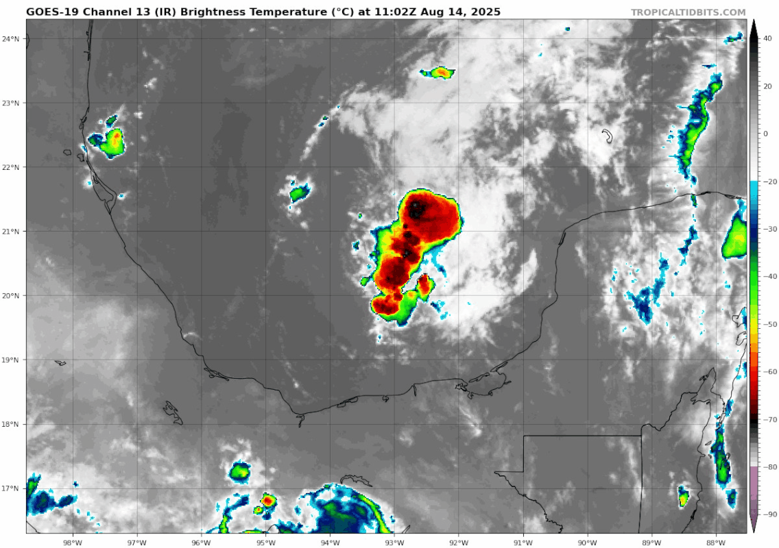
Quite convectively active this morning.
0 likes
TC naming lists: retirements and intensity
Most aggressive Advisory #1's in North Atlantic (cr. kevin for starting the list)
Most aggressive Advisory #1's in North Atlantic (cr. kevin for starting the list)
Re: ATL: INVEST 98L - Discussion
Teban54 wrote:Quite convectively active this morning.
https://i.postimg.cc/SN2KFyyy/goes19-ir-98-L-202508141102.gif
Is the SW Gulf going to once again “overperform”?
0 likes
Personal Forecast Disclaimer:
The posts in this forum are NOT official forecasts and should not be used as such. They are just the opinion of the poster and may or may not be backed by sound meteorological data. They are NOT endorsed by any professional institution or storm2k.org. For official information, please refer to the NHC and NWS products.
The posts in this forum are NOT official forecasts and should not be used as such. They are just the opinion of the poster and may or may not be backed by sound meteorological data. They are NOT endorsed by any professional institution or storm2k.org. For official information, please refer to the NHC and NWS products.
-
hurricane2025
- Category 1

- Posts: 254
- Joined: Thu Apr 08, 2021 10:36 am
-
TomballEd
- Category 5
- Posts: 1346
- Age: 62
- Joined: Wed Aug 16, 2023 4:52 pm
- Location: Spring/Klein area, not Tomball
Re: ATL: INVEST 98L - Discussion
I think it runs out of time to get more than a low end tropical storm, if that. But either way, might be a PTC today to issue warnings for the Mexican coast. I'm 98% sure this doesn't Humberto but it looks like its trying on satellite.
After weeks without at the house as I watched KHOU-11 weather showing storms everywhere but my yard, I had t-storms two days in a row. If it moves fairly quickly and drops 2 or 3 more inches of rain IMBY, I'm quite happy with it. I've learned to fear Cat 1 hurricanes, it killed power at my house for almost a week.

After weeks without at the house as I watched KHOU-11 weather showing storms everywhere but my yard, I had t-storms two days in a row. If it moves fairly quickly and drops 2 or 3 more inches of rain IMBY, I'm quite happy with it. I've learned to fear Cat 1 hurricanes, it killed power at my house for almost a week.
2 likes
-
TomballEd
- Category 5
- Posts: 1346
- Age: 62
- Joined: Wed Aug 16, 2023 4:52 pm
- Location: Spring/Klein area, not Tomball
Re: ATL: INVEST 98L - Discussion
Quick look at CIMSS concentrated vorticity 850/925 mb level, elongated on a N-S axis 700 and 500 mb. The stretched N-S satellite presentation may be because of stretched vorticity 700 mb and above.
1 likes
-
cycloneye
- Admin
- Posts: 149846
- Age: 69
- Joined: Thu Oct 10, 2002 10:54 am
- Location: San Juan, Puerto Rico
Re: ATL: INVEST 98L - Discussion
Recon flying now. Yes!!!!
5 likes
Visit the Caribbean-Central America Weather Thread where you can find at first post web cams,radars
and observations from Caribbean basin members Click Here
and observations from Caribbean basin members Click Here
-
jaguars_22
- Category 2

- Posts: 629
- Joined: Tue Jun 20, 2017 2:26 pm
- Location: Victoria TX
Re: ATL: INVEST 98L - Discussion
The more north she can get the worse. More Time over water and a landfall in coastal bend… could get interesting fast!!
1 likes

-
jaguars_22
- Category 2
- Posts: 629
- Joined: Tue Jun 20, 2017 2:26 pm
- Location: Victoria TX
-
MGC

- S2K Supporter

- Posts: 5941
- Joined: Sun Mar 23, 2003 9:05 pm
- Location: Pass Christian MS, or what is left.
Re: ATL: INVEST 98L - Discussion
Will be interesting to see what Recon finds. Could be something hiding under all that convection.....MGC
0 likes
-
jaguars_22
- Category 2
- Posts: 629
- Joined: Tue Jun 20, 2017 2:26 pm
- Location: Victoria TX
Re: ATL: INVEST 98L - Discussion
My bet and I'm not a weatherman... Id say landfall in Corpus as a tropical storm ~60mph
I agree with MGC something is hiding under that northern part of the convection...
I agree with MGC something is hiding under that northern part of the convection...
0 likes
Who is online
Users browsing this forum: No registered users and 38 guests