ATL: ERIN - Post-Tropical - Discussion
Moderator: S2k Moderators
-
cainjamin

- Tropical Storm

- Posts: 173
- Age: 34
- Joined: Mon Apr 17, 2017 1:38 pm
- Location: Nova Scotia, Canada
Re: ATL: ERIN - Hurricane - Discussion
Erin is the first August category 5 since Hurricane Dean in 2007 almost 20 years ago!
3 likes
Noel '07, Kyle '08, Earl '10, Arthur '14, Dorian '19, Teddy '20, Lee '23


Re: ATL: ERIN - Hurricane - Discussion
CronkPSU wrote:like yeah...i know it is going to turn, every model says it is going to turn but if i was in Puerto Rico right now...i'd be having my doubts right now
like if it was this close to cocoa beach, i would bepoopingmyself in East Orlando rn lol
IIRC, some models like the HFAS solutions were showing a more westward track due to stronger storms combined with the more westerly high level winds a couple days ago.
Erin has been massively outperforming every models thus far.
2 likes
-
Hurricane Mike
- Category 2

- Posts: 675
- Joined: Tue Apr 10, 2018 7:44 am
Re: ATL: ERIN - Hurricane - Discussion
cainjamin wrote:Erin is the first August category 5 since Hurricane Dean in 2007 almost 20 years ago!
Crazy it has been that long!
0 likes


Re: ATL: ERIN - Hurricane - Discussion
Not sure if it's been mentioned yet in this thread as new posts have been coming in quickly - and also perhaps because it's too obvious to mention - but with the 18z advisory, Erin became the most intense tropical cyclone of 2025 so far, with one-minute winds as high as, and central pressure at least 4 hPa deeper than, Cyclone Errol's at its estimated peak on 16 April.
6 likes

-
Sciencerocks
- Category 5

- Posts: 10181
- Age: 40
- Joined: Thu Jul 06, 2017 1:51 am
Re: ATL: ERIN - Hurricane - Discussion
cainjamin wrote:Erin is the first August category 5 since Hurricane Dean in 2007 almost 20 years ago!
The last five August Category 5 hurricanes in the Atlantic basin, based on available data, are:Hurricane Erin - August 16, 2025
Hurricane Dorian - August 31, 2019
Hurricane Dean - August 20, 2007
Hurricane Andrew - August 23, 1992
Hurricane Allen - August 5-7, 1980
1 likes

Re: ATL: ERIN - Hurricane - Discussion
Somehow, Erin continues to look more impressive. It also started symmetrizing again immediately after I commented that its CDO was less symmetrical than before.
2 likes
TC naming lists: retirements and intensity
Most aggressive Advisory #1's in North Atlantic (cr. kevin for starting the list)
Most aggressive Advisory #1's in North Atlantic (cr. kevin for starting the list)
-
jconsor
- Professional-Met

- Posts: 580
- Joined: Mon Jun 30, 2008 9:31 pm
- Location: Jerusalem, Israel
- Contact:
Re: ATL: ERIN - Hurricane - Discussion
Powerful Hurricane Erin continues to track on the southern edge of the model spread on Sat, as shown in the image attached to the below Twitter/X post. Erin's actual track in six hour increments is shown in the black X's, with NHC's main consensus forecast model TVCN shown in blue, with darker shades indicating more recent forecast model runs. You can see Erin made a notable bend to the left (turning from west-northwest to due west) in the past 12-18 hours and is currently about 50-75 miles south of consensus model forecasts from 24 hours ago.
https://x.com/yconsor/status/1956796579173585043
Here's an in-depth post I wrote on Fri describing my concerns that ensemble forecasts are underdoing W. Atl ridging, and explaining why US impacts can't be ruled out yet. It wasn't posted until now due to coming down with a stomach virus and some technical issues. My thoughts on Erin's track and potential US impacts haven't changed much since Fri.
Would appreciate if you can take a look at the Substack blog post on Erin below and send me feedback/suggestions (you can message me here or write to hurricanehacker@substack.com), as well as spread the word about my Substack. Thank you guys!
https://hurricanehacker.substack.com/p/ ... evelopment
Last edited by jconsor on Sat Aug 16, 2025 3:53 pm, edited 3 times in total.
4 likes

Re: ATL: ERIN - Hurricane - Discussion
Sciencerocks wrote:cainjamin wrote:Erin is the first August category 5 since Hurricane Dean in 2007 almost 20 years ago!
The last five August Category 5 hurricanes in the Atlantic basin, based on available data, are:Hurricane Erin - August 16, 2025
Hurricane Dorian - August 31, 2019
Hurricane Dean - August 20, 2007
Hurricane Andrew - August 23, 1992
Hurricane Allen - August 5-7, 1980
And Katrina
1 likes
Re: ATL: ERIN - Hurricane - Discussion
zzzh wrote:https://i.imgur.com/Aroragg.png
Wow
That reminds me of Irma when it underwent more of a meld than a true ERC.
1 likes
Re: ATL: ERIN - Hurricane - Discussion
Sciencerocks wrote:cainjamin wrote:Erin is the first August category 5 since Hurricane Dean in 2007 almost 20 years ago!
The last five August Category 5 hurricanes in the Atlantic basin, based on available data, are:Hurricane Erin - August 16, 2025
Hurricane Dorian - August 31, 2019
Hurricane Dean - August 20, 2007
Hurricane Andrew - August 23, 1992
Hurricane Allen - August 5-7, 1980
Dorian wasn't a cat 5 until 06z on September 1st. Also you forgot Katrina.
3 likes
-
Category5Kaiju

- Category 5
- Posts: 4331
- Joined: Thu Dec 24, 2020 12:45 pm
- Location: Seattle and Phoenix
Re: ATL: ERIN - Hurricane - Discussion

Erin is still under a pocket of very favorable shear, so unless internal processes get in the way, I expect this storm to remain steady or even intensify a little bit more in the coming hours.
This storm is....phenomenal, to say the least. The way it just catapulted from a minimal hurricane to a high-end Category 4 overnight, along with its small eye, really reminds me of Milton from last year. I'm very thankful that it's north of the islands, because had that pivot near the Cape Verde Islands not occurred for Erin's precursor, then we could've been looking at an Irma/Maria-level event again.
7 likes
Unless explicitly stated, all info in my posts is based on my own opinions and observations. Tropical storms and hurricanes can be extremely dangerous. Refer to an accredited weather research agency or meteorologist if you need to make serious decisions regarding an approaching storm.
Re: ATL: ERIN - Hurricane - Discussion
more radar loop (same parallel lines as last shot)
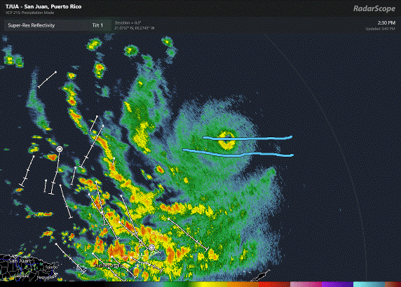
earlier loop:
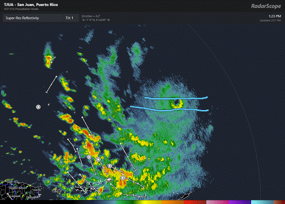
earlier loop:
Last edited by BobHarlem on Sat Aug 16, 2025 2:43 pm, edited 1 time in total.
0 likes


Re: ATL: ERIN - Hurricane - Discussion
That is impressive!!! Perfect fish storm! Not worried about Bermuda, they are well prepared if it gets closer.
0 likes
The following post is NOT an official forecast and should not be used as such. It is just the opinion of the poster and may or may not be backed by sound meteorological data. It is NOT endorsed by any professional institution including storm2k.org For Official Information please refer to the NHC and NWS products.
Re: ATL: ERIN - Hurricane - Discussion
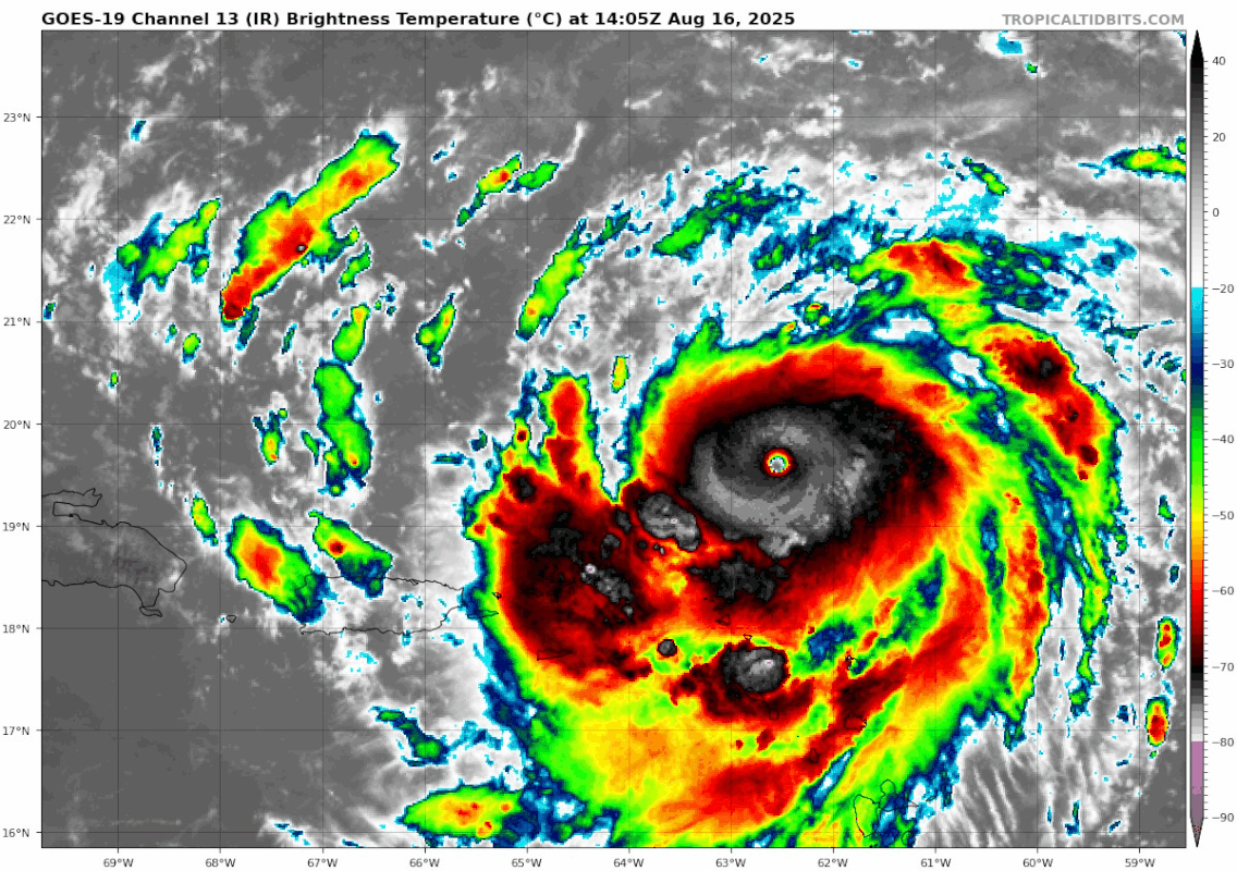
That ring is so close to solid, definitely something going on in the northern section.
https://www.tropicaltidbits.com/sat/sat ... uct=dvorak
https://www.tropicaltidbits.com/sat/sat ... uct=dvorak
0 likes
-
Sciencerocks
- Category 5
- Posts: 10181
- Age: 40
- Joined: Thu Jul 06, 2017 1:51 am


Re: ATL: ERIN - Hurricane - Discussion
ljmac75 wrote:Sciencerocks wrote:cainjamin wrote:Erin is the first August category 5 since Hurricane Dean in 2007 almost 20 years ago!
The last five August Category 5 hurricanes in the Atlantic basin, based on available data, are:Hurricane Erin - August 16, 2025
Hurricane Dorian - August 31, 2019
Hurricane Dean - August 20, 2007
Hurricane Andrew - August 23, 1992
Hurricane Allen - August 5-7, 1980
Dorian wasn't a cat 5 until 06z on September 1st. Also you forgot Katrina.
Officially, yeah. But there was good evidence it was a Cat 5 as early as the evening on August 31st, even though the NHC went with 130 kt.
0 likes
Irene '11 Sandy '12 Hermine '16 5/15/2018 Derecho Fay '20 Isaias '20 Elsa '21 Henri '21 Ida '21
I am only a meteorology enthusiast who knows a decent amount about tropical cyclones. Look to the professional mets, the NHC, or your local weather office for the best information.
I am only a meteorology enthusiast who knows a decent amount about tropical cyclones. Look to the professional mets, the NHC, or your local weather office for the best information.
-
Sciencerocks
- Category 5
- Posts: 10181
- Age: 40
- Joined: Thu Jul 06, 2017 1:51 am
Re: ATL: ERIN - Hurricane - Discussion
ljmac75 wrote:Sciencerocks wrote:cainjamin wrote:Erin is the first August category 5 since Hurricane Dean in 2007 almost 20 years ago!
The last five August Category 5 hurricanes in the Atlantic basin, based on available data, are:Hurricane Erin - August 16, 2025
Hurricane Dorian - August 31, 2019
Hurricane Dean - August 20, 2007
Hurricane Andrew - August 23, 1992
Hurricane Allen - August 5-7, 1980
Dorian wasn't a cat 5 until 06z on September 1st. Also you forgot Katrina.
Yeah, sadly grok poop the bed. lol I should have read what it said as I would have realized something was fishy!
 Be very careful when using these tools as they aint accurate enough to get the job done.
 gpt-5 got it right
List the last 5 August cat5 in the Atlantic
Here are the most recent five Atlantic Category 5 hurricanes that reached that intensity in August, including the brand-new Hurricane Erin (2025):
Last 5 August Category 5 Hurricanes in the Atlantic
Hurricane Erin – August 16, 2025
Became a Category 5 hurricane unusually early in the season—before August 16. It's the earliest Atlantic Category 5 on record, second only to Hurricane Allen (1980) in terms of early-season intensity.
Hurricane Dean – August 20–21, 2007
Strong Cape Verde hurricane that attained Category 5 status and made landfall on the Yucatán Peninsula as a Category 5.
Wikipedia
Hurricane Katrina – August 28, 2005 (Peak)
Rapidly intensified to Category 5 over the Gulf of Mexico on August 28 before weakening to Category 3 at landfall on August 29.
Hurricane Andrew – August 23–24, 1992
Intensified to Category 5 intensity on August 23–24, making devastating landfalls in the Bahamas and southern Florida.
Hurricane Allen (1980)- Aug 5–10, 1980-Reached 190 mph winds. One of the strongest Atlantic hurricanes on record.
Hurricane Camille – August 16–18, 1969
Reached Category 5 strength and made landfall in Mississippi as a powerful Category 5 hurricane.
1 likes
-
Hurricane2022

- Category 5
- Posts: 2016
- Joined: Tue Aug 23, 2022 11:38 pm
- Location: Araçatuba, Brazil
Re: ATL: ERIN - Hurricane - Discussion
The eye isn't warm as it was before, but i'm not sure if this has stopped from intensifying, since it still looks wonderful both on VIS and IR. My bet is that Recon may find a sub-910 storm later today.
2 likes
Sorry for the bad English sometimes...!
For reliable and detailed information for any meteorological phenomenon, please consult the National Hurricane Center, Joint Typhoon Warning Center , or your local Meteo Center.
--------
ECCE OMNIA NOVA FACIAM (Ap 21,5).
For reliable and detailed information for any meteorological phenomenon, please consult the National Hurricane Center, Joint Typhoon Warning Center , or your local Meteo Center.
--------
ECCE OMNIA NOVA FACIAM (Ap 21,5).
Who is online
Users browsing this forum: No registered users and 31 guests