
ATL: ERIN - Post-Tropical - Discussion
Moderator: S2k Moderators
-
Hypercane_Kyle

- Category 5

- Posts: 3465
- Joined: Sat Mar 07, 2015 7:58 pm
- Location: Cape Canaveral, FL
Re: ATL: ERIN - Hurricane - Discussion
Beautiful, classic Cape Verde major hurricane despite the EWRC. Once that wraps up, I bet we get a 20-30 nautical mile eye.
11 likes
My posts are my own personal opinion, defer to the National Hurricane Center (NHC) and other NOAA products for decision making during hurricane season.

-
wxman57

- Moderator-Pro Met

- Posts: 23174
- Age: 68
- Joined: Sat Jun 21, 2003 8:06 pm
- Location: Houston, TX (southwest)
Re: ATL: ERIN - Hurricane - Discussion
Recon supports Cat 2 intensity now - 85-90 kts. While its pressure may fall over the next day or two, its wind field will be expanding. That will reduce the pressure gradient. May not reach Cat 3 again but its wind field will be a lot larger.
3 likes
Re: ATL: ERIN - Hurricane - Discussion
North of west turn appears to have started in ernest now.
2 likes
Re: ATL: ERIN - Hurricane - Discussion
Interesting callout in the 11 am advisory, which I hope folks realize at it gets closer to the OBX... it'll be downright dangerous surf/rip currents in parts:
"It should be
noted that the 34- and 50-kt wind speed probabilities beyond 36
hours in the text and graphical products are likely underestimating
the risk of those winds occurring. This is because the forecast
wind field of Erin is considerably larger than average compared to
the wind field used to derive the wind speed probability product."
3 likes
Re: ATL: ERIN - Hurricane - Discussion
Report from Recon now indicates no inner eyewall.
Looks like ERWRC is done.
Circular closed eye 40nm wide
Looks like ERWRC is done.
Circular closed eye 40nm wide
1 likes
Re: ATL: ERIN - Hurricane - Discussion
Recon needs to resample NE quad to get an idea of its intensity.
AF304 has been sitting on the runway in Biloxi for some time now.
AF304 has been sitting on the runway in Biloxi for some time now.
0 likes
-
dukeblue219
- S2K Supporter

- Posts: 556
- Joined: Fri Sep 30, 2016 3:52 pm
Re: ATL: ERIN - Hurricane - Discussion
Tight band of storms firing off right now around the eyewall.
0 likes

Re: ATL: ERIN - Hurricane - Discussion
It will take a while to clean up its structure, but I imagine by tonight it'll start reintensifying albeit at a slower rate due to size. The warmest waters are still ahead of it around 27N, I doubt we'll see another Cat 5 peak though. It's just like a figure skater putting her arms out, the energy is still there.GCANE wrote:Recon needs to resample NE quad to get an idea of its intensity.
AF304 has been sitting on the runway in Biloxi for some time now.
6 likes
-
tolakram
- Admin

- Posts: 20185
- Age: 62
- Joined: Sun Aug 27, 2006 8:23 pm
- Location: Florence, KY (name is Mark)
Re: ATL: ERIN - Hurricane - Discussion
Even if it doesn't "clean up" it's structure these big lumbering hurricanes can do a lot of widespread damage without ever making landfall. Unless the forecast path changes to the east I expect some level of evacuation recommended for the outer banks.
4 likes
M a r k
- - - - -
Join us in chat: Storm2K Chatroom Invite. Android and IOS apps also available.
The posts in this forum are NOT official forecasts and should not be used as such. Posts are NOT endorsed by any professional institution or STORM2K.org. For official information and forecasts, please refer to NHC and NWS products.

Re: ATL: ERIN - Hurricane - Discussion
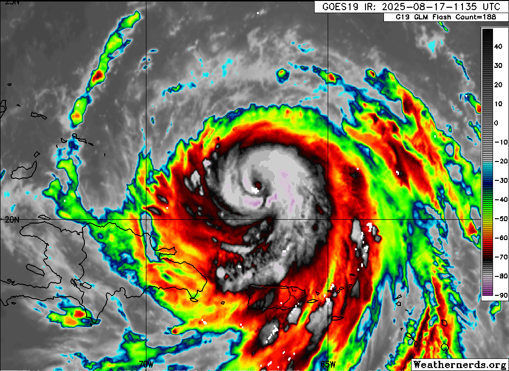
Erin has had one of the most persistent inner eyewalls I’ve ever seen. Looks like the outer eyewall is finally taking over, but there’s still an interior wind maxima from the inner eyewall based on the last pass (110/90kt NE and 75/60kt SW). Maybe by tonight the outer eyewall will finally completely take over.
0 likes
Irene '11 Sandy '12 Hermine '16 5/15/2018 Derecho Fay '20 Isaias '20 Elsa '21 Henri '21 Ida '21
I am only a meteorology enthusiast who knows a decent amount about tropical cyclones. Look to the professional mets, the NHC, or your local weather office for the best information.
I am only a meteorology enthusiast who knows a decent amount about tropical cyclones. Look to the professional mets, the NHC, or your local weather office for the best information.

Re: ATL: ERIN - Hurricane - Discussion
tolakram wrote:. Unless the forecast path changes to the east I expect some level of evacuation recommended for the outer banks.
That's a tough sell at peak tourist season in the OBX. Even if a direct hit were to be forecast, few 'bankers will leave , short of a major hurricane.
There's a lot of cams along the OBX to watch.
5 likes
I'm not a meteorologist, I'm an electronics engineer. While I can probably fix your toaster oven, you're not going to learn about storms from me!
New Mexico had no hurricanes. Then I moved to NC right before Fran.....
New Mexico had no hurricanes. Then I moved to NC right before Fran.....
-
emeraldislenc
- Category 2

- Posts: 601
- Joined: Fri Aug 24, 2012 4:49 pm
- Location: Emerald Isle NC
Re: ATL: ERIN - Hurricane - Discussion
NHC mentioned OBX in their 2 pm advisory and the hurricane force winds are expanding!
2 likes
-
cheezyWXguy

- Category 5
- Posts: 6282
- Joined: Mon Feb 13, 2006 12:29 am
- Location: Dallas, TX
Re: ATL: ERIN - Hurricane - Discussion
This cycle seems to be just about wrapped up. Remnant of the inner eye still there, but looks to be on its last leg as either some higher cloud filaments or singular tower that’s trying to hold out before it’s ultimately integrated into the surrounding eyewall. Overall the new core is looking healthier to me on satellite than a few hours ago.
2 likes
-
emeraldislenc
- Category 2
- Posts: 601
- Joined: Fri Aug 24, 2012 4:49 pm
- Location: Emerald Isle NC
Re: ATL: ERIN - Hurricane - Discussion
Maybe a tough sell during Tourist season but some of the OBX is only reached by Ferries so the Emergency Management always take that into consideration along with the overwash on Highway 12.
1 likes
Re: ATL: ERIN - Hurricane - Discussion
There will be large delays in shipping and anything naval related that much is for sure. The waves are going to be treacherous. During Larry my community had to replace some sections of seawall from the large swells. I imagine Erin will be similar, hopefully nothing to bad.tolakram wrote:Even if it doesn't "clean up" it's structure these big lumbering hurricanes can do a lot of widespread damage without ever making landfall. Unless the forecast path changes to the east I expect some level of evacuation recommended for the outer banks.
1 likes
-
wxman57
- Moderator-Pro Met
- Posts: 23174
- Age: 68
- Joined: Sat Jun 21, 2003 8:06 pm
- Location: Houston, TX (southwest)
Re: ATL: ERIN - Hurricane - Discussion
Extratropical storm surge page indicates tides 1-2 ft above normal as Erin passes. Surf's up Tue-Wed. I still see nothing to indicate Erin is still a Cat 3. The NHC always plays it safe and never downgrades a storm that's impacting any land areas. Can't fault them for that. It's quite normal for a hurricane's wind field to expand after an eyewall replacement. Erin's going to get very large by the time it passes between Bermuda and the OB.
https://slosh.nws.noaa.gov/etss/index.php?glat=All&display=0&type=stormtide&base=Ocean/World_Ocean_Base
https://slosh.nws.noaa.gov/etss/index.php?glat=All&display=0&type=stormtide&base=Ocean/World_Ocean_Base
2 likes
Re: ATL: ERIN - Hurricane - Discussion
Erin has transitioned into a big smudgey grunge-cane. Big and very powerful with a relentlessly growing windfield. The bigger it gets...even if it's peak intensity is less...the more menacing it is as water action and the beach erosion threat will increase. It's going to be a beach eater with some overwash and coastal flooding up and down the eastern seaboard. Rip currents will definitely pose a multi day risk
1 likes
-
HurricaneIrma
- Tropical Low

- Posts: 43
- Age: 45
- Joined: Mon Sep 03, 2018 9:37 am
- Location: Wilmington NC
Re: ATL: ERIN - Hurricane - Discussion
Will possible hurricane watches go up for the Outer Banks does anybody think in the next couple days
0 likes
-
wxman57
- Moderator-Pro Met
- Posts: 23174
- Age: 68
- Joined: Sat Jun 21, 2003 8:06 pm
- Location: Houston, TX (southwest)
Re: ATL: ERIN - Hurricane - Discussion
HurricaneIrma wrote:Will possible hurricane watches go up for the Outer Banks does anybody think in the next couple days
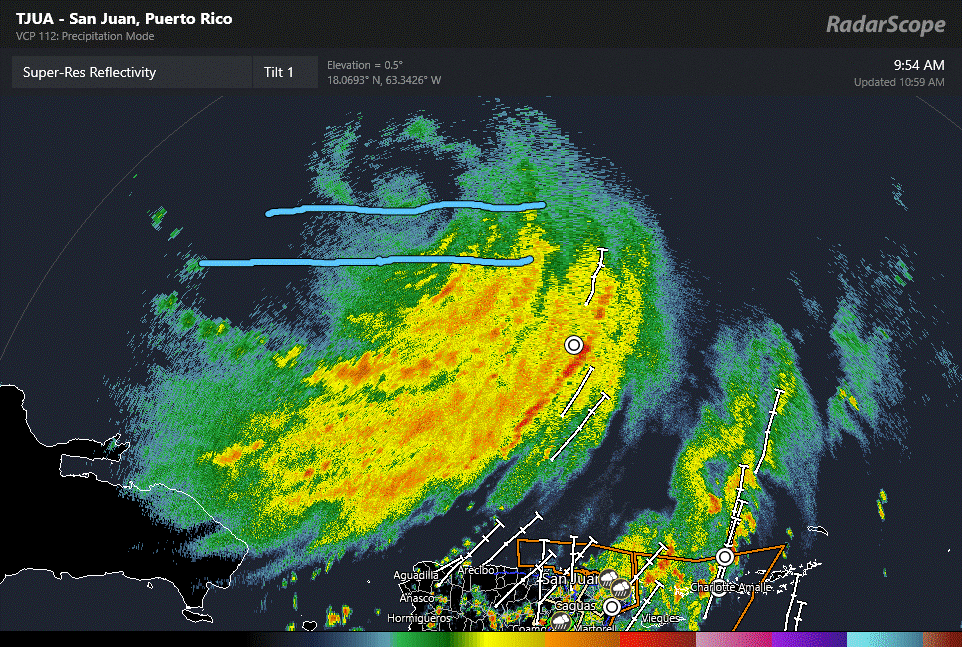
I doubt it. Erin may pass close enough to produce 25-30 mph wind there, but that's about it. TS watches should have been issued for San Juan, though. No sustained TS wind but gusts to 40 kts in squalls.
1 likes
Who is online
Users browsing this forum: No registered users and 7 guests