ATL: ERIN - Post-Tropical - Discussion
Moderator: S2k Moderators


Re: ATL: ERIN - Hurricane - Discussion
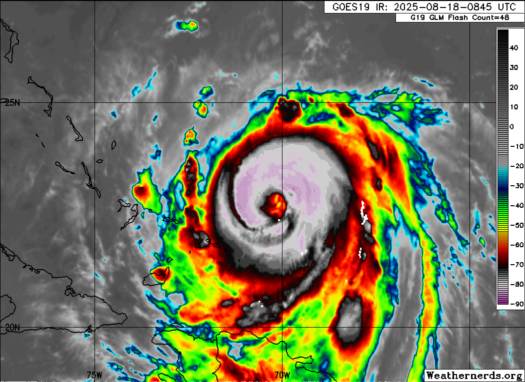
GCANE wrote:Drop splashed at 937mb
22.8N 70.5W
Keep shifting track west
2 likes
-
weeniepatrol

- Category 5

- Posts: 1343
- Joined: Sat Aug 22, 2020 5:30 pm
- Location: WA State

Re: ATL: ERIN - Hurricane - Discussion
Rain rate up to 68 mm/hr.
Looks like latent heat release is working to strengthen Erin.
Looks like latent heat release is working to strengthen Erin.
1 likes

-
weeniepatrol
- Category 5
- Posts: 1343
- Joined: Sat Aug 22, 2020 5:30 pm
- Location: WA State


Re: ATL: ERIN - Hurricane - Discussion

Recon clearly shows how big Erin's wind field has become.
0 likes
-
weeniepatrol
- Category 5
- Posts: 1343
- Joined: Sat Aug 22, 2020 5:30 pm
- Location: WA State

Re: ATL: ERIN - Hurricane - Discussion
AF recon's dropsonde missed the true center of the eye, SSW winds at 20 knots, meaning that is is a little further west.
0 likes
Re: ATL: ERIN - Hurricane - Discussion
000
WTNT35 KNHC 181152
TCPAT5
BULLETIN
Hurricane Erin Intermediate Advisory Number 28A
NWS National Hurricane Center Miami FL AL052025
800 AM EDT Mon Aug 18 2025
...LARGE AND POWERFUL HURRICANE ERIN LOCATED JUST EAST OF THE
SOUTHEAST BAHAMAS...
...LIFE-THREATENING SURF AND RIP CURRENTS LIKELY ACROSS THE U.S.
EASTERN SEABOARD THIS WEEK...
SUMMARY OF 800 AM EDT...1200 UTC...INFORMATION
----------------------------------------------
LOCATION...23.1N 70.5W
ABOUT 115 MI...190 KM NNE OF GRAND TURK ISLAND
ABOUT 890 MI...1430 KM SSE OF CAPE HATTERAS NORTH CAROLINA
MAXIMUM SUSTAINED WINDS...130 MPH...215 KM/H
PRESENT MOVEMENT...NW OR 305 DEGREES AT 13 MPH...20 KM/H
MINIMUM CENTRAL PRESSURE...933 MB...27.55 INCHES
0 likes
Re: ATL: ERIN - Hurricane - Discussion
Some of the islands getting into the main shield area.
0 likes
Re: ATL: ERIN - Hurricane - Discussion
kevin wrote:000
WTNT35 KNHC 181152
TCPAT5
BULLETIN
Hurricane Erin Intermediate Advisory Number 28A
NWS National Hurricane Center Miami FL AL052025
800 AM EDT Mon Aug 18 2025
...LARGE AND POWERFUL HURRICANE ERIN LOCATED JUST EAST OF THE
SOUTHEAST BAHAMAS...
...LIFE-THREATENING SURF AND RIP CURRENTS LIKELY ACROSS THE U.S.
EASTERN SEABOARD THIS WEEK...
SUMMARY OF 800 AM EDT...1200 UTC...INFORMATION
----------------------------------------------
LOCATION...23.1N 70.5W
ABOUT 115 MI...190 KM NNE OF GRAND TURK ISLAND
ABOUT 890 MI...1430 KM SSE OF CAPE HATTERAS NORTH CAROLINA
MAXIMUM SUSTAINED WINDS...130 MPH...215 KM/H
PRESENT MOVEMENT...NW OR 305 DEGREES AT 13 MPH...20 KM/H
MINIMUM CENTRAL PRESSURE...933 MB...27.55 INCHES
There they go with their extrap track fixes instead of actual recon fixes.
1 likes

Re: ATL: ERIN - Hurricane - Discussion
A hurricane watch would’ve been a good idea for the Turks and Caicos, lol
2 likes
Igor 2010, Sandy 2012, Fay 2014, Gonzalo 2014, Joaquin 2015, Nicole 2016, Humberto 2019, Imelda 2025
I am only a tropical weather enthusiast. My predictions are not official and may or may not be backed by sound meteorological data. For official information, please refer to the NHC and NWS products.
I am only a tropical weather enthusiast. My predictions are not official and may or may not be backed by sound meteorological data. For official information, please refer to the NHC and NWS products.


Re: ATL: ERIN - Hurricane - Discussion
Wowie. Haven't really been commenting but watching this storm and looks like it is getting closer to land every run. Assuming still no landfall. But curious to know later in the week how close this could get to Atlantic Canada. Major wildfires going on in this area at the moment and wondering if this could cause high winds to exacerbate the issue here without bringing any rain?
0 likes
Not a professional meteorologist. Please refer to NHC forecasts for official information/advice relating to tropical systems.
Re: ATL: ERIN - Hurricane - Discussion
NOAA2 found 133 kt FL winds, definitely enough for an upgrade to 120 kt.
2 likes
-
TampaWxLurker
- Tropical Storm

- Posts: 196
- Joined: Thu Aug 01, 2024 8:20 am
Re: ATL: ERIN - Hurricane - Discussion
Not to get too model thread talk in the main thread, but boy the ICON did a good job sniffing out this West tendency for track. Clearly the NHC didn't buy it. But this has got to be catching people in the Turks and Caicos by surprise. A Hurricane Watch wouldn't have been a bad idea.
3 likes
Re: ATL: ERIN - Hurricane - Discussion
NDG wrote:kevin wrote:000
WTNT35 KNHC 181152
TCPAT5
BULLETIN
Hurricane Erin Intermediate Advisory Number 28A
NWS National Hurricane Center Miami FL AL052025
800 AM EDT Mon Aug 18 2025
...LARGE AND POWERFUL HURRICANE ERIN LOCATED JUST EAST OF THE
SOUTHEAST BAHAMAS...
...LIFE-THREATENING SURF AND RIP CURRENTS LIKELY ACROSS THE U.S.
EASTERN SEABOARD THIS WEEK...
SUMMARY OF 800 AM EDT...1200 UTC...INFORMATION
----------------------------------------------
LOCATION...23.1N 70.5W
ABOUT 115 MI...190 KM NNE OF GRAND TURK ISLAND
ABOUT 890 MI...1430 KM SSE OF CAPE HATTERAS NORTH CAROLINA
MAXIMUM SUSTAINED WINDS...130 MPH...215 KM/H
PRESENT MOVEMENT...NW OR 305 DEGREES AT 13 MPH...20 KM/H
MINIMUM CENTRAL PRESSURE...933 MB...27.55 INCHES
There they go with their extrap track fixes instead of actual recon fixes.
Yeah maybe they're waiting for the 11am advisory to update their track. But it's a bit weird, both recon (including dropsondes) and IR/VIS of the storm all clearly show the center being at 22.8N.
0 likes
Who is online
Users browsing this forum: No registered users and 13 guests