ATL: ERIN - Models

Moderator: S2k Moderators

Message
Author
User avatar
ronjon
Category 5
Category 5
Posts: 4839
Joined: Fri Aug 19, 2005 5:17 pm
Location: Hernando Beach, FL

Re: ATL: ERIN - Models

#541 Postby ronjon » Mon Aug 18, 2025 6:04 am

kevin wrote:A few days ago we were all (including me) already giving the win to GFS and the Euro. But it now seems that Erin is once again another big win for ICON. It is the only model that showed the more SW track of Erin early on and is pretty much spot on with its current location if you use the models from 3 - 5 days ago. Even the often best performing TVCN was about 3 degrees too far north if you use the models from Thursday morning. The Euro eventually also shifted west, but GFS was way too far east for a very long time.


The GFS always seems to have to play catchup to the Euro and ICON. It was either Helene or Milton (sorry memories bad) from last year it consistently had the storm way west into the FL panhandle - so much so that it pulled the consensus track west at landfall by about 30 miles. Icon had nailed the landfall.
2 likes   

TallyTracker
Category 2
Category 2
Posts: 756
Joined: Thu Oct 11, 2018 2:46 pm

Re: ATL: ERIN - Models

#542 Postby TallyTracker » Mon Aug 18, 2025 6:48 am

ronjon wrote:
kevin wrote:A few days ago we were all (including me) already giving the win to GFS and the Euro. But it now seems that Erin is once again another big win for ICON. It is the only model that showed the more SW track of Erin early on and is pretty much spot on with its current location if you use the models from 3 - 5 days ago. Even the often best performing TVCN was about 3 degrees too far north if you use the models from Thursday morning. The Euro eventually also shifted west, but GFS was way too far east for a very long time.


The GFS always seems to have to play catchup to the Euro and ICON. It was either Helene or Milton (sorry memories bad) from last year it consistently had the storm way west into the FL panhandle - so much so that it pulled the consensus track west at landfall by about 30 miles. Icon had nailed the landfall.


It was Helene. That 30 miles got the eye away from my house.
1 likes   
Fran '96, Georges '98, Gordon '00, Gabrielle '01, Charley '04, Frances '04, Jeanne '04, Barry '07, Fay '08, Debby '12, Matthew '16, Emily '17, Irma '17, Michael ‘18, Elsa ‘21, Fred ‘21, Mindy ‘21, Nicole ‘22, Idalia ‘23, Debby ‘24, Helene ‘24

BobHarlem
Category 5
Category 5
Posts: 2362
Joined: Thu Oct 20, 2005 6:11 pm

Re: ATL: ERIN - Models

#543 Postby BobHarlem » Mon Aug 18, 2025 6:52 am

6z icon gets to 74.4W, lowest pressure 908mb midday Wednesday.

closest to OBX here:
Image
1 likes   

jlauderdal
S2K Supporter
S2K Supporter
Posts: 7210
Joined: Wed May 19, 2004 5:46 am
Location: NE Fort Lauderdale
Contact:

Re: ATL: ERIN - Models

#544 Postby jlauderdal » Mon Aug 18, 2025 7:00 am

BobHarlem wrote:6z icon gets to 74.4W, lowest pressure 908mb midday Wednesday.

closest to OBX here:
https://i.imgur.com/KilwwfE.png

Its been consistent if nothing else and must be taken seriously, especially at this range.
5 likes   

TampaWxLurker
Tropical Storm
Tropical Storm
Posts: 157
Joined: Thu Aug 01, 2024 8:20 am

Re: ATL: ERIN - Models

#545 Postby TampaWxLurker » Mon Aug 18, 2025 7:33 am

All hail ICON. :notworthy:
4 likes   

User avatar
syfr
S2K Supporter
S2K Supporter
Posts: 201
Age: 106
Joined: Fri Oct 26, 2012 7:33 pm
Location: East Central NC

Re: ATL: ERIN - Models

#546 Postby syfr » Mon Aug 18, 2025 7:37 am

We'll see how/if the two tracks converge.

They're not tremendously different at this point. NHC has the ultimate eastern turn earlier, and drops it from a Major above about 33N


Image
0 likes   
I'm not a meteorologist, I'm an electronics engineer. While I can probably fix your toaster oven, you're not going to learn about storms from me!

New Mexico had no hurricanes. Then I moved to NC right before Fran.....

User avatar
REDHurricane
Category 1
Category 1
Posts: 415
Age: 28
Joined: Sun Jul 03, 2022 2:36 pm
Location: Northeast Pacific Ocean

Re: ATL: ERIN - Models

#547 Postby REDHurricane » Mon Aug 18, 2025 8:22 am

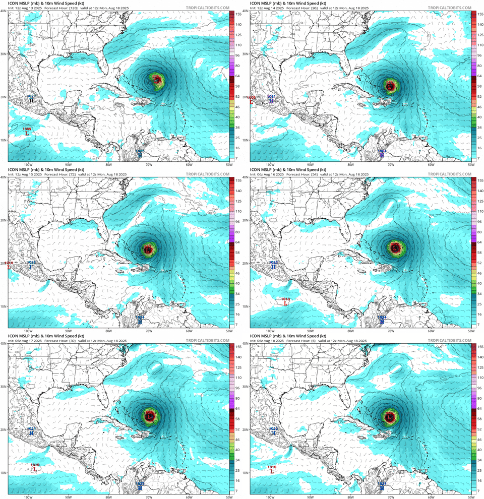
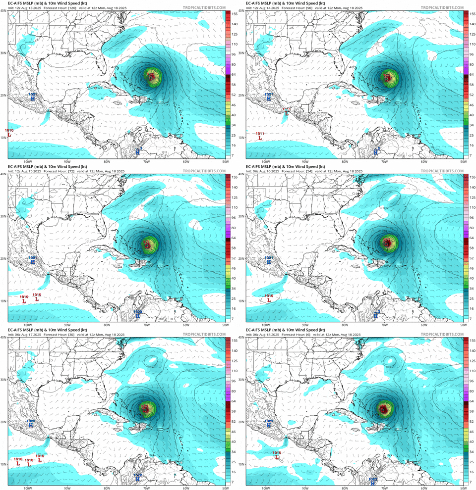
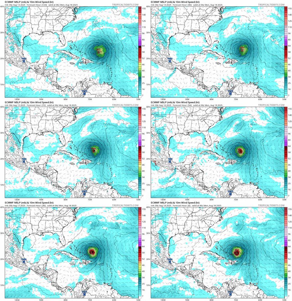
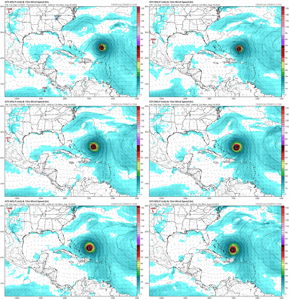
5-day forecast gif from the 8/13 12z model runs to now, ranked by track accuracy:

#1: ICON
Image


#2: Euro AI
Image


#3: ECMWF
Image


#4: GFS
Image

Disclaimer: I didn't actually do the math but these rankings seem pretty apparent (except for #2 and #3, hard to tell for sure with those) based on the eye test, if someone wants to calculate mean track error for each of these 80 model runs to verify (lol) then please feel free to double check my work
2 likes   

User avatar
GCANE
S2K Supporter
S2K Supporter
Posts: 11640
Joined: Mon Oct 22, 2007 8:03 am

Re: ATL: ERIN - Models

#548 Postby GCANE » Mon Aug 18, 2025 8:47 am

HMON is now making a big shift to the west

Image
0 likes   

User avatar
kevin
Category 5
Category 5
Posts: 2658
Age: 26
Joined: Wed Aug 28, 2019 4:35 am

Re: ATL: ERIN - Models

#549 Postby kevin » Mon Aug 18, 2025 8:48 am

06z Euro joins ICON in showing a secondary C5 peak for Erin (wind estimates from Euro are often conservative but 907mb must be at least a low-end C5).

Image
5 likes   

BobHarlem
Category 5
Category 5
Posts: 2362
Joined: Thu Oct 20, 2005 6:11 pm

Re: ATL: ERIN - Models

#550 Postby BobHarlem » Mon Aug 18, 2025 10:29 am

slight left shift near the obx on 12z icon, 74.5W is western most which is .1 right of the earlier run, 913mb lowest pressure

Image
1 likes   

BobHarlem
Category 5
Category 5
Posts: 2362
Joined: Thu Oct 20, 2005 6:11 pm

Re: ATL: ERIN - Models

#551 Postby BobHarlem » Mon Aug 18, 2025 11:14 am

12z UKMET is left of icon, and a left shift from the 0z. Western post point is 74.7W (at 31.7N) lowest pressure this run is 947mb.

Image
0 likes   

User avatar
ronjon
Category 5
Category 5
Posts: 4839
Joined: Fri Aug 19, 2005 5:17 pm
Location: Hernando Beach, FL

Re: ATL: ERIN - Models

#552 Postby ronjon » Mon Aug 18, 2025 12:02 pm

I suspect if 12z UKMET track verifies, Cape Hatteras may be within the hurricane wind radius - which now is 120 miles from center. In 3 days, they may even extend further with Erin's projected increase in size.
2 likes   

BobHarlem
Category 5
Category 5
Posts: 2362
Joined: Thu Oct 20, 2005 6:11 pm

Re: ATL: ERIN - Models

#553 Postby BobHarlem » Mon Aug 18, 2025 12:59 pm

12z Euro, another left shift here from 0z. Westernmost: 74.4W, lowest pressure 919mb I'd expect TS Watches up on the OBX tonight or tomorrow.
Image
1 likes   

BobHarlem
Category 5
Category 5
Posts: 2362
Joined: Thu Oct 20, 2005 6:11 pm

Re: ATL: ERIN - Models

#554 Postby BobHarlem » Mon Aug 18, 2025 3:00 pm

12z euro wave heights:
Image
1 likes   

User avatar
Woofde
Category 2
Category 2
Posts: 516
Joined: Tue Jul 06, 2021 11:33 am

Re: ATL: ERIN - Models

#555 Postby Woofde » Mon Aug 18, 2025 3:21 pm

BobHarlem wrote:12z Euro, another left shift here from 0z. Westernmost: 74.4W, lowest pressure 919mb I'd expect TS Watches up on the OBX tonight or tomorrow.
Image
I was honestly expecting the ICON to be the one to cave to the consensus, not the other way around. It's really knocking it out of the park with this storm, consistently keeping it south and west. I wonder what's different with it that allows the model to pick up on patterns so far in advance of the rest.
5 likes   

IcyTundra
Category 5
Category 5
Posts: 1220
Joined: Mon Jun 07, 2021 9:32 pm
Location: Dickinson, Texas

Re: RE: Re: ATL: ERIN - Models

#556 Postby IcyTundra » Mon Aug 18, 2025 3:35 pm

Woofde wrote:
BobHarlem wrote:12z Euro, another left shift here from 0z. Westernmost: 74.4W, lowest pressure 919mb I'd expect TS Watches up on the OBX tonight or tomorrow.
https://i.imgur.com/khy6iHK.png
I was honestly expecting the ICON to be the one to cave to the consensus, not the other way around. It's really knocking it out of the park with this storm, consistently keeping it south and west. I wonder what's different with it that allows the model to pick up on patterns so far in advance of the rest.


The ICON has certainly had its fair share of wins the last couple seasons. It consistently showed Beryl taking a more eastern track into the Central Texas coast when the GFS and Euro were insisting on a Mexico landfall. Maybe the NHC should consider including it with the other models they use as guidance in future seasons.
1 likes   

BobHarlem
Category 5
Category 5
Posts: 2362
Joined: Thu Oct 20, 2005 6:11 pm

Re: ATL: ERIN - Models

#557 Postby BobHarlem » Mon Aug 18, 2025 4:24 pm

Very slight left shift in the 18z icon close to OBX. Overall Western most point 74.5W, lowest pressure 910mb
Image
0 likes   

User avatar
Emmett_Brown
Category 5
Category 5
Posts: 1433
Joined: Wed Aug 24, 2005 9:10 pm
Location: Sarasota FL

Re: ATL: ERIN - Models

#558 Postby Emmett_Brown » Mon Aug 18, 2025 5:15 pm

18Z GFS is a bit left of 12z, closer to the Icon now
0 likes   

BobHarlem
Category 5
Category 5
Posts: 2362
Joined: Thu Oct 20, 2005 6:11 pm

Re: ATL: ERIN - Models

#559 Postby BobHarlem » Mon Aug 18, 2025 7:02 pm

18z Euro (usually paywalled) is to the left also
 https://x.com/RyanMaue/status/1957592924847321442


Image
1 likes   

User avatar
Jr0d
S2K Supporter
S2K Supporter
Posts: 1437
Joined: Tue Aug 27, 2019 10:52 am
Location: Cayo Hueso

Re: ATL: ERIN - Models

#560 Postby Jr0d » Tue Aug 19, 2025 8:32 am

Looking at the simulated IR model for the GFS and CMC, even 12 hours from now they both have much different solutions for strengthen. The CMC shows Erin struggling and never regaining a core while the GFS(as well as the EURO and ICON) show Erin to really ramp up tonight.

This is GFS vs CMC comparison for later tonight:

Image

Image
0 likes   


Return to “2025”

Who is online

Users browsing this forum: hipshot and 26 guests