ATL: ERIN - Post-Tropical - Discussion
Moderator: S2k Moderators
-
cheezyWXguy

- Category 5

- Posts: 6282
- Joined: Mon Feb 13, 2006 12:29 am
- Location: Dallas, TX
Re: ATL: ERIN - Hurricane - Discussion
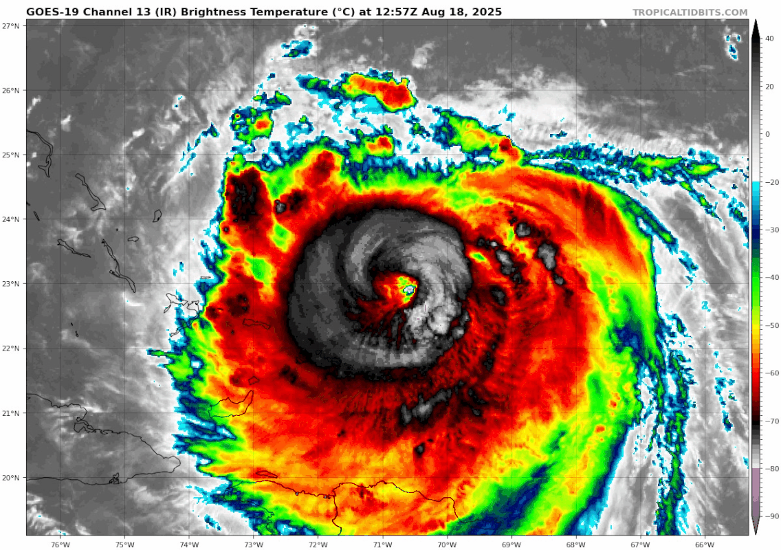
Erin looked better early this morning; the generally flat pressure trend and cloud filled eye may suggest it’s starting to feel the effects of shear.
4 likes
Re: ATL: ERIN - Hurricane - Discussion
https://x.com/treytwister_wx/status/1957411988260217146
x: Ummm ok. #Erin is about to be like that kid that screws around too long and misses a ride on the school bus. That trough to the north is very close to passing by #Erin and start its more substantial pull to the north. Going to be a very close call, but it should start soon.
x: Ummm ok. #Erin is about to be like that kid that screws around too long and misses a ride on the school bus. That trough to the north is very close to passing by #Erin and start its more substantial pull to the north. Going to be a very close call, but it should start soon.
4 likes


Re: ATL: ERIN - Hurricane - Discussion
Thanks bud.wxman57 wrote:DW5522 wrote:Hey guys I normally just stick to the winter threads but my brother is leaving for South Carolina Tuesday, what kind of conditions can they expect? Maybe just rain, wind and rough surf?
Rough surf late tomorrow through Thursday. Tides maybe 1-2 feet higher than normal. North wind 25 mph or so.
0 likes
-
cycloneye

- Admin

- Posts: 149463
- Age: 69
- Joined: Thu Oct 10, 2002 10:54 am
- Location: San Juan, Puerto Rico
Re: ATL: ERIN - Hurricane - Discussion
0 likes
Visit the Caribbean-Central America Weather Thread where you can find at first post web cams,radars
and observations from Caribbean basin members Click Here
and observations from Caribbean basin members Click Here

Re: ATL: ERIN - Hurricane - Discussion
11AM position
23.1N 70.8W
last recon vortex:
22.92N 70.68W
Not sure why they are deviating so much.
23.1N 70.8W
last recon vortex:
22.92N 70.68W
Not sure why they are deviating so much.
2 likes
-
TampaWxLurker
- Tropical Storm

- Posts: 196
- Joined: Thu Aug 01, 2024 8:20 am
Re: ATL: ERIN - Hurricane - Discussion
Was moving at 305° at 8am, now at 11am listed as 300°.
0 likes


Re: ATL: ERIN - Hurricane - Discussion
Clearly feeling some shear (and maybe upwelling).
1 likes
TC naming lists: retirements and intensity
Most aggressive Advisory #1's in North Atlantic (cr. kevin for starting the list)
Most aggressive Advisory #1's in North Atlantic (cr. kevin for starting the list)

Re: ATL: ERIN - Hurricane - Discussion
cheezyWXguy wrote:Erin looked better early this morning; the generally flat pressure trend and cloud filled eye may suggest it’s starting to feel the effects of shear.
Yeah it took too long with the EWRC and missed its optimal window for re-intensification. The eye is very clouded now, and earlier I noticed that outflow on the northern side seemed restricted.
Shear should peak tomorrow and then another option for intensification could be on Wednesday, when a huge outflow channel opens to the north as it gets picked up and recurves.
2 likes
Irene '11 Sandy '12 Hermine '16 5/15/2018 Derecho Fay '20 Isaias '20 Elsa '21 Henri '21 Ida '21
I am only a meteorology enthusiast who knows a decent amount about tropical cyclones. Look to the professional mets, the NHC, or your local weather office for the best information.
I am only a meteorology enthusiast who knows a decent amount about tropical cyclones. Look to the professional mets, the NHC, or your local weather office for the best information.

Re: ATL: ERIN - Hurricane - Discussion
Hmm, I wonder if there is some sort of decoupling going on.
IR relative to Recon looks weird.
IR relative to Recon looks weird.
1 likes
-
Category5Kaiju

- Category 5
- Posts: 4333
- Joined: Thu Dec 24, 2020 12:45 pm
- Location: Seattle and Phoenix
Re: ATL: ERIN - Hurricane - Discussion
Not sure if it means much in the long run, but the recent NHC update has Erin moving WNW at 10 mph.
The previous update had Erin moving NW at 13 mph.
The previous update had Erin moving NW at 13 mph.
3 likes
Unless explicitly stated, all info in my posts is based on my own opinions and observations. Tropical storms and hurricanes can be extremely dangerous. Refer to an accredited weather research agency or meteorologist if you need to make serious decisions regarding an approaching storm.
-
tolakram
- Admin
- Posts: 20185
- Age: 62
- Joined: Sun Aug 27, 2006 8:23 pm
- Location: Florence, KY (name is Mark)
Re: ATL: ERIN - Hurricane - Discussion
This is the Cirrus only view from COD. Looking north of Erin you can see some of the cloud tops moving south, indicating shear. In a no shear environment the outflow should be rotating clockwise away from the storm.

5 likes
M a r k
- - - - -
Join us in chat: Storm2K Chatroom Invite. Android and IOS apps also available.
The posts in this forum are NOT official forecasts and should not be used as such. Posts are NOT endorsed by any professional institution or STORM2K.org. For official information and forecasts, please refer to NHC and NWS products.
-
ScottNAtlanta

- Category 5
- Posts: 2535
- Joined: Sat May 25, 2013 3:11 pm
- Location: Atlanta, GA
Re: ATL: ERIN - Hurricane - Discussion
tolakram wrote:This is the Cirrus only view from COD. Looking north of Erin you can see some of the cloud tops moving south, indicating shear. In a no shear environment the outflow should be rotating clockwise away from the storm.
https://i.imgur.com/BwykaHQ.gif
Yes there does seem to be some shear, and the eye is starting to be less distinct
2 likes
The posts in this forum are NOT official forecast and should not be used as such. They are just the opinion of the poster and may or may not be backed by sound meteorological data. They are NOT endorsed by any professional institution or storm2k.org. For official information, please refer to the NHC and NWS products.
-
ScottNAtlanta
- Category 5
- Posts: 2535
- Joined: Sat May 25, 2013 3:11 pm
- Location: Atlanta, GA
Re: ATL: ERIN - Hurricane - Discussion
We have now passed the avg ACE for this date as Erin will continue to add ACE points
5 likes
The posts in this forum are NOT official forecast and should not be used as such. They are just the opinion of the poster and may or may not be backed by sound meteorological data. They are NOT endorsed by any professional institution or storm2k.org. For official information, please refer to the NHC and NWS products.

Re: ATL: ERIN - Hurricane - Discussion
That would be up at the north end of O'coke , heading to Hatteras. Thankfully that ferry runs pretty frequently.
1 likes
I'm not a meteorologist, I'm an electronics engineer. While I can probably fix your toaster oven, you're not going to learn about storms from me!
New Mexico had no hurricanes. Then I moved to NC right before Fran.....
New Mexico had no hurricanes. Then I moved to NC right before Fran.....
Re: ATL: ERIN - Hurricane - Discussion
It looks like it has stalled and is now drifting north. Not unexpected.
1 likes

Re: ATL: ERIN - Hurricane - Discussion
xironman wrote:It looks like it has stalled and is now drifting north. Not unexpected.
There is a second TUTT to the north that cut off up near Maine and is rolling east.
Doesn't look like we will get a third TUTT looks more like the eastern periphery of a high will be dropping some shear onto ERIN from the north.
Weakness would be way back around Colorado in that case but 72 hours makes a big difference.
Some of this fluid motion is random, that is why they need to evacuate in case the models are off by 150 miles after 72 hours.

0 likes

Re: ATL: ERIN - Hurricane - Discussion
syfr wrote:
That would be up at the north end of O'coke , heading to Hatteras. Thankfully that ferry runs pretty frequently.
There are no homes on the North end of Ocracoke Island. Much of the island has eroded away. If this photo represents traffic leaving Ocracoke (or already crossed) to cross Hatteras Inlet, the line is about ten miles long on Ocracoke. This could be traffic being lined up on Hatteras Island to meter traffic through 50 miles of two lane road.
1 likes
Who is online
Users browsing this forum: No registered users and 4 guests