Mark Sudduth has a bunch of cameras out there on Rodanthe
Link: https://youtu.be/cBzCR9kd0is
https://www.youtube.com/watch?v=cBzCR9kd0is
ATL: ERIN - Post-Tropical - Discussion
Moderator: S2k Moderators
-
wxman57

- Moderator-Pro Met

- Posts: 23174
- Age: 68
- Joined: Sat Jun 21, 2003 8:06 pm
- Location: Houston, TX (southwest)
Re: ATL: ERIN - Hurricane - Discussion
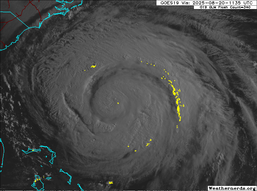
SFMR indicates max winds are around 75 kts now. Note that the wind field is expanding significantly. That means a lower pressure will not translate into increasing wind since the pressure gradient is decreasing. I'm not surprised that the NHC is keeping the winds up, as they never want to indicate weakening for a storm that is affecting land in any way. If they were to issue an advisory saying Erin was now a Cat 1, then people may not heed the warnings along the coast. The primary impact along the East Coast will be from very large waves and a dangerous rip current rather than wind. All squalls should pass offshore.
3 likes


Re: ATL: ERIN - Hurricane - Discussion
I was checking out the Surfline cams earlier and saw people walking on the beach in Frisco(just south of of the Cape on the OBX). With the roads almost certainly going to be washed out it they will be stuck. The aftermath of no electricity, no way of getting food and fresh water for awhile is something many don't consider when they think they are in a safe place despite being under a mandatory evacuation.
In a few hours the outer rain bands will start to impact the Outer Banks.
Surfline Frisco Cam
In a few hours the outer rain bands will start to impact the Outer Banks.
Surfline Frisco Cam
2 likes
Re: ATL: ERIN - Hurricane - Discussion
I’ll find the article again later and link it. Wrightsville beach NC has issued a no swim warning through Friday. They pulled 50 people from rip currents on Monday and a few dozen on Tuesday.
This is such a large storm. How large will it peak at? I’m not surprised at all to see Erin give it a go at some intensification now it’s attempting to organize and exercise out the dry air slots. Warm surface water is great hurricane juice. Not sure how it will be able to sustain strengthening within it being so large and not well organized
This is such a large storm. How large will it peak at? I’m not surprised at all to see Erin give it a go at some intensification now it’s attempting to organize and exercise out the dry air slots. Warm surface water is great hurricane juice. Not sure how it will be able to sustain strengthening within it being so large and not well organized
1 likes
-
TampaWxLurker
- Tropical Storm

- Posts: 196
- Joined: Thu Aug 01, 2024 8:20 am

Re: ATL: ERIN - Hurricane - Discussion
Recon has found an abundance of flight level winds around 115kts. 90% reduction gives a wind speed of 10-105kts, even if we are very harsh and use a 80% reduction thats still ~90kts. SFMR is far less reliable, no reason to downgrade when plenty of evidence for Cat 2.wxman57 wrote:SFMR indicates max winds are around 75 kts now. Note that the wind field is expanding significantly. That means a lower pressure will not translate into increasing wind since the pressure gradient is decreasing. I'm not surprised that the NHC is keeping the winds up, as they never want to indicate weakening for a storm that is affecting land in any way. If they were to issue an advisory saying Erin was now a Cat 1, then people may not heed the warnings along the coast. The primary impact along the East Coast will be from very large waves and a dangerous rip current rather than wind. All squalls should pass offshore.
8 likes
-
tolakram
- Admin

- Posts: 20185
- Age: 62
- Joined: Sun Aug 27, 2006 8:23 pm
- Location: Florence, KY (name is Mark)
Re: ATL: ERIN - Hurricane - Discussion
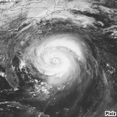
saved loop.

14 likes
M a r k
- - - - -
Join us in chat: Storm2K Chatroom Invite. Android and IOS apps also available.
The posts in this forum are NOT official forecasts and should not be used as such. Posts are NOT endorsed by any professional institution or STORM2K.org. For official information and forecasts, please refer to NHC and NWS products.

Re: ATL: ERIN - Hurricane - Discussion
Wow, what a beautiful beast!
One of the best I've seen in a while.
6 likes

Re: ATL: ERIN - Hurricane - Discussion
Just a huge storm.

7 likes
Igor 2010, Sandy 2012, Fay 2014, Gonzalo 2014, Joaquin 2015, Nicole 2016, Humberto 2019, Imelda 2025
I am only a tropical weather enthusiast. My predictions are not official and may or may not be backed by sound meteorological data. For official information, please refer to the NHC and NWS products.
I am only a tropical weather enthusiast. My predictions are not official and may or may not be backed by sound meteorological data. For official information, please refer to the NHC and NWS products.

Re: ATL: ERIN - Hurricane - Discussion
Now to watch for the Eastern turn...
1 likes
I'm not a meteorologist, I'm an electronics engineer. While I can probably fix your toaster oven, you're not going to learn about storms from me!
New Mexico had no hurricanes. Then I moved to NC right before Fran.....
New Mexico had no hurricanes. Then I moved to NC right before Fran.....
-
wxman57
- Moderator-Pro Met
- Posts: 23174
- Age: 68
- Joined: Sat Jun 21, 2003 8:06 pm
- Location: Houston, TX (southwest)
Re: RE: Re: ATL: ERIN - Hurricane - Discussion
Woofde wrote:Recon has found an abundance of flight level winds around 115kts. 90% reduction gives a wind speed of 10-105kts, even if we are very harsh and use a 80% reduction thats still ~90kts. SFMR is far less reliable, no reason to downgrade when plenty of evidence for Cat 2.wxman57 wrote:SFMR indicates max winds are around 75 kts now. Note that the wind field is expanding significantly. That means a lower pressure will not translate into increasing wind since the pressure gradient is decreasing. I'm not surprised that the NHC is keeping the winds up, as they never want to indicate weakening for a storm that is affecting land in any way. If they were to issue an advisory saying Erin was now a Cat 1, then people may not heed the warnings along the coast. The primary impact along the East Coast will be from very large waves and a dangerous rip current rather than wind. All squalls should pass offshore.
The problem is that those stronger FL winds were nowhere near the eyewall, and those conversions were developed for wind reduction within the eyewall. The plane was actually measuring surface winds, which is better than FL-SFC reductions. Plane didn't find any surface wind much above 75 kts.
I'm measuring a 3hr movement of 012 deg at 11 kts. It's not looking like the sustained TS wind for Cape Hatteras. All squalls should remain offshore. I expect Hatteras to get north wind at 20-30 kts tonight/tomorrow morning. Tides about 3 ft above normal there. No significant rain.
3 likes
Re: ATL: ERIN - Hurricane - Discussion
The FL ratio of 90% is for the eyewall yes, but you can still use reductions for the outer vortex at ~80%, provided that section of storm is convectively active(no problem there). It is possible that the ratio is lower than the usual conversion, but given how much the trust in SFMR has been eroded, I can easily see why they would hold the intensity at Cat 2.wxman57 wrote:Woofde wrote:Recon has found an abundance of flight level winds around 115kts. 90% reduction gives a wind speed of 10-105kts, even if we are very harsh and use a 80% reduction thats still ~90kts. SFMR is far less reliable, no reason to downgrade when plenty of evidence for Cat 2.wxman57 wrote:SFMR indicates max winds are around 75 kts now. Note that the wind field is expanding significantly. That means a lower pressure will not translate into increasing wind since the pressure gradient is decreasing. I'm not surprised that the NHC is keeping the winds up, as they never want to indicate weakening for a storm that is affecting land in any way. If they were to issue an advisory saying Erin was now a Cat 1, then people may not heed the warnings along the coast. The primary impact along the East Coast will be from very large waves and a dangerous rip current rather than wind. All squalls should pass offshore.
The problem is that those stronger FL winds were nowhere near the eyewall, and those conversions were developed for wind reduction within the eyewall. The plane was actually measuring surface winds, which is better than FL-SFC reductions. Plane didn't find any surface wind much above 75 kts.
I'm measuring a 3hr movement of 012 deg at 11 kts. It's not looking like the sustained TS wind for Cape Hatteras. All squalls should remain offshore. I expect Hatteras to get north wind at 20-30 kts tonight/tomorrow morning. Tides about 3 ft above normal there. No significant rain.

2 likes
-
Iceresistance

- Category 5

- Posts: 9589
- Age: 22
- Joined: Sat Oct 10, 2020 9:45 am
- Location: Tecumseh, OK/Norman, OK
Re: ATL: ERIN - Hurricane - Discussion
What is this microwave pass, is that a portal to another dimension? 
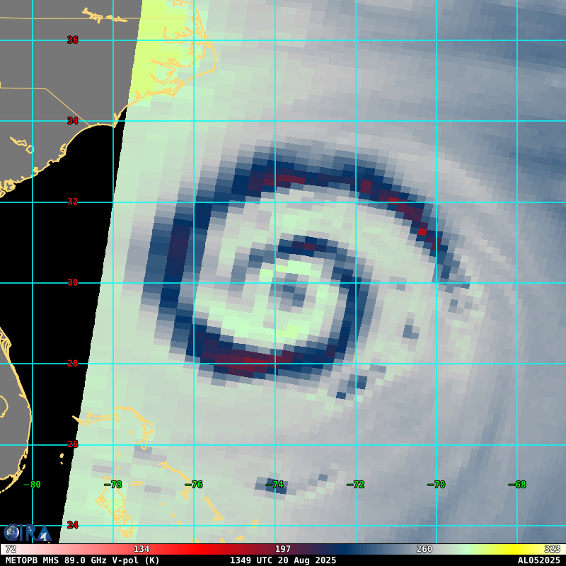
https://s14.gifyu.com/images/bNrzw.png
https://s14.gifyu.com/images/bNrzw.png
18 likes
Bill 2015 & Beta 2020
Winter 2020-2021
All observations are in Tecumseh, OK unless otherwise noted.
Winter posts are focused mainly for Oklahoma & Texas.
Take any of my forecasts with a grain of salt, refer to the NWS, SPC, and NHC for official information
Never say Never with weather! Because ANYTHING is possible!
Winter 2020-2021
All observations are in Tecumseh, OK unless otherwise noted.
Winter posts are focused mainly for Oklahoma & Texas.
Take any of my forecasts with a grain of salt, refer to the NWS, SPC, and NHC for official information
Never say Never with weather! Because ANYTHING is possible!


Re: ATL: ERIN - Hurricane - Discussion
Iceresistance wrote:What is this microwave pass, is that a portal to another dimension?
https://s14.gifyu.com/images/bNrzw.png
https://s14.gifyu.com/images/bNrzw.png
That appears to be the infamous triple moat. Been a long time since I’ve seen it, I think it was Ike. But yeah, Erin is a mess
0 likes
-
mrbagyo

- Category 5
- Posts: 3963
- Age: 33
- Joined: Thu Apr 12, 2012 9:18 am
- Location: 14.13N 120.98E
- Contact:
Re: ATL: ERIN - Hurricane - Discussion
Y'all just hungry hallucinating with Erin's appearance.
17 likes
The posts in this forum are NOT official forecast and should not be used as such. They are just the opinion of the poster and may or may not be backed by sound meteorological data. They are NOT endorsed by any professional institution or storm2k.org. For official information, please refer to RSMC, NHC and NWS products.
Re: ATL: ERIN - Hurricane - Discussion
Was just watching folks on Ocracoke towing sailboats at anchor in the harbor over to near the ferry docks with a skiff, to ride out Erin.
1 likes
I'm not a meteorologist, I'm an electronics engineer. While I can probably fix your toaster oven, you're not going to learn about storms from me!
New Mexico had no hurricanes. Then I moved to NC right before Fran.....
New Mexico had no hurricanes. Then I moved to NC right before Fran.....
-
HurricaneEnzo

- Category 2

- Posts: 743
- Joined: Wed Mar 14, 2018 12:18 pm
- Location: Newport, NC (Hurricane Alley)
Re: ATL: ERIN - Hurricane - Discussion
Erin's appearance is reminding me of Hurricane Allen in the Gulf. Massive storm.
Sent from my Pixel 8 Pro using Tapatalk

Sent from my Pixel 8 Pro using Tapatalk
10 likes
Bertha 96' - Fran 96' - Bonnie 98' - Dennis 99' - Floyd 99' - Isabel 03' - Alex 04' - Ophelia 05' - Irene 11' - Arthur 14' - Matthew 16' - Florence 18' - Dorian 19' - Isaias 20' (countless other tropical storms and Hurricane swipes)
I am not a Professional Met just an enthusiast. Get your weather forecasts from the Pros!
I am not a Professional Met just an enthusiast. Get your weather forecasts from the Pros!
-
storm_in_a_teacup

- Category 2
- Posts: 500
- Age: 33
- Joined: Wed Aug 16, 2017 5:01 pm
- Location: Huntsville, Alabama (originally from Houston)
- Contact:
Re: ATL: ERIN - Hurricane - Discussion
tolakram wrote:saved loop
https://i.imgur.com/tcOgrYN.gif
Link to full size: https://i.imgur.com/tcOgrYN.gif (right click open in new tab)
Cinnamon roll!
EDIT: oops someone beat me to it...
Last edited by storm_in_a_teacup on Wed Aug 20, 2025 2:23 pm, edited 1 time in total.
2 likes
I know I can't straddle the atmosphere...just a tiny storm in your teacup, girl.
Who is online
Users browsing this forum: No registered users and 6 guests