
ATL: ERIN - Post-Tropical - Discussion
Moderator: S2k Moderators
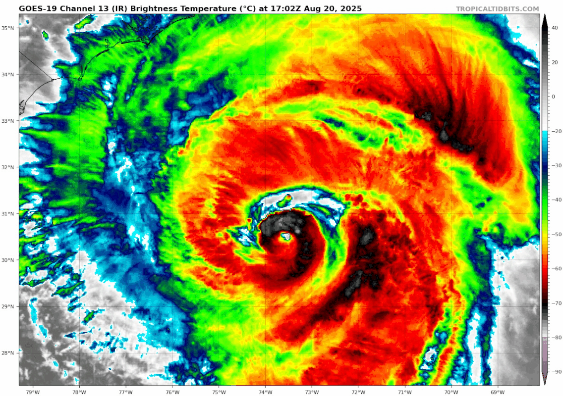
Re: ATL: ERIN - Hurricane - Discussion
The eye was really recovering earlier, but it seems short-lived.
0 likes
TC naming lists: retirements and intensity
Most aggressive Advisory #1's in North Atlantic (cr. kevin for starting the list)
Most aggressive Advisory #1's in North Atlantic (cr. kevin for starting the list)

Re: ATL: ERIN - Hurricane - Discussion
Erin has evolved from a cinnamon roll to quite the tasty donut on microwave now, with a moat about 50 miles wide between the eyewall and banding.
 |  |
9 likes
-
AnnularCane

- S2K Supporter

- Posts: 2962
- Joined: Thu Jun 08, 2006 9:18 am
- Location: Wytheville, VA
Re: ATL: ERIN - Hurricane - Discussion
I'm getting hungry for something sweet. 
2 likes
"But it never rained rain. It never snowed snow. And it never blew just wind. It rained things like soup and juice. It snowed mashed potatoes and green peas. And sometimes the wind blew in storms of hamburgers." -- Judi Barrett, Cloudy with a Chance of Meatballs
-
cycloneye

- Admin

- Posts: 149463
- Age: 69
- Joined: Thu Oct 10, 2002 10:54 am
- Location: San Juan, Puerto Rico
Re: ATL: ERIN - Hurricane - Discussion
From the 5 PM discussion about the size.
Erin is an usually large hurricane. For hurricanes north of 30N
latitude, its tropical-storm-force wind radii are in the 75th percentile of the Atlantic basin record.
Erin is an usually large hurricane. For hurricanes north of 30N
latitude, its tropical-storm-force wind radii are in the 75th percentile of the Atlantic basin record.
5 likes
Visit the Caribbean-Central America Weather Thread where you can find at first post web cams,radars
and observations from Caribbean basin members Click Here
and observations from Caribbean basin members Click Here
-
mrbagyo

- Category 5

- Posts: 3963
- Age: 33
- Joined: Thu Apr 12, 2012 9:18 am
- Location: 14.13N 120.98E
- Contact:
Re: ATL: ERIN - Hurricane - Discussion
Travorum wrote:Erin has evolved from a cinnamon roll to quite the tasty donut on microwave now, with a moat about 50 miles wide between the eyewall and banding.
https://i.imgur.com/OE1hzag.png https://i.imgur.com/iQohHye.png
Nearly the same structure as Typhoon Winnie of 1997
0 likes
The posts in this forum are NOT official forecast and should not be used as such. They are just the opinion of the poster and may or may not be backed by sound meteorological data. They are NOT endorsed by any professional institution or storm2k.org. For official information, please refer to RSMC, NHC and NWS products.
-
Sciencerocks
- Category 5
- Posts: 10186
- Age: 40
- Joined: Thu Jul 06, 2017 1:51 am


Re: ATL: ERIN - Hurricane - Discussion
Definitely heading NE fast......
NHC nailed this.
NHC nailed this.
5 likes
I'm not a meteorologist, I'm an electronics engineer. While I can probably fix your toaster oven, you're not going to learn about storms from me!
New Mexico had no hurricanes. Then I moved to NC right before Fran.....
New Mexico had no hurricanes. Then I moved to NC right before Fran.....
-
wxman57

- Moderator-Pro Met

- Posts: 23174
- Age: 68
- Joined: Sat Jun 21, 2003 8:06 pm
- Location: Houston, TX (southwest)
Re: ATL: ERIN - Hurricane - Discussion
Obs along the NC coast as of 6pm EDT are NE 5-10 kts with light rain. Even Hatteras has only 5 kt wind. Wind field is a bit smaller than predicted, and the storm is tracking just a little farther offshore.
2 likes
-
USTropics
- Professional-Met

- Posts: 2738
- Joined: Sun Aug 12, 2007 3:45 am
- Location: Florida State University
Re: ATL: ERIN - Hurricane - Discussion
A full day of visible satellite imagery for Erin. Still in awe of her size and power:

13 likes
Re: ATL: ERIN - Hurricane - Discussion
Ocracoke (OBX) live shot. Erin blowin' on by

1 likes
I'm not a meteorologist, I'm an electronics engineer. While I can probably fix your toaster oven, you're not going to learn about storms from me!
New Mexico had no hurricanes. Then I moved to NC right before Fran.....
New Mexico had no hurricanes. Then I moved to NC right before Fran.....

Re: ATL: ERIN - Hurricane - Discussion
I hope Ocracoke and silver lake rain like this! This is the most special beach in NC in my opinion. Allom and Pop businesses, great surf fishing, and a great inlet to head out to Gulf Stream. I am told some people actually catch fish!
2 likes
-
Keldeo1997
- Category 2

- Posts: 688
- Joined: Fri Oct 11, 2019 11:35 pm
Re: ATL: ERIN - Hurricane - Discussion
Link: https://youtube.com/watch?v=IUNZ2hOyGi4
Erin is trying to copy Winnie with that structure
Dare I say it is annular possible?
0 likes
-
wxman57
- Moderator-Pro Met
- Posts: 23174
- Age: 68
- Joined: Sat Jun 21, 2003 8:06 pm
- Location: Houston, TX (southwest)
Re: ATL: ERIN - Hurricane - Discussion
Erin is definitely tracking east of the forecast. I doubt there will be any TS wind on the OBX. Hatteras is currently NE at 10 kts gusting 22 kts. Plane found 70-75 kts in SW quadrant.
4 likes
-
cycloneye
- Admin
- Posts: 149463
- Age: 69
- Joined: Thu Oct 10, 2002 10:54 am
- Location: San Juan, Puerto Rico
Re: ATL: ERIN - Hurricane - Discussion
0 likes
Visit the Caribbean-Central America Weather Thread where you can find at first post web cams,radars
and observations from Caribbean basin members Click Here
and observations from Caribbean basin members Click Here

Re: ATL: ERIN - Hurricane - Discussion
wxman57 wrote:Erin is definitely tracking east of the forecast. I doubt there will be any TS wind on the OBX. Hatteras is currently NE at 10 kts gusting 22 kts. Plane found 70-75 kts in SW quadrant.
So, in your professional opinion, does this increase the threat to Bermuda? I've actually been wondering all day why their government hasn't upgraded the tropical-storm watch to a tropical-storm warning. Granted, the infrastructure there is legendary but still...
0 likes

Re: ATL: ERIN - Hurricane - Discussion
Nice to see the storm going further east than expected which hopefully will minimize the over wash on the OBX.
Still at another high tide cycle tomorrow morning to get through.
Still at another high tide cycle tomorrow morning to get through.
2 likes
-
wxman57
- Moderator-Pro Met
- Posts: 23174
- Age: 68
- Joined: Sat Jun 21, 2003 8:06 pm
- Location: Houston, TX (southwest)
Re: ATL: ERIN - Hurricane - Discussion
abajan wrote:wxman57 wrote:Erin is definitely tracking east of the forecast. I doubt there will be any TS wind on the OBX. Hatteras is currently NE at 10 kts gusting 22 kts. Plane found 70-75 kts in SW quadrant.
So, in your professional opinion, does this increase the threat to Bermuda? I've actually been wondering all day why their government hasn't upgraded the tropical-storm watch to a tropical-storm warning. Granted, the infrastructure there is legendary but still...
No, not a Bermuda threat. It's passing too far northwest of Bermuda. Not much for the East U.S. Coast, either, as it looks like it has begun the NE turn early. Hatters has only 10 kts gusting 25 kts. No TS sustained wind on the East Coast.
P.S. Recon found max wind of 75 kts in any quadrant of Erin, regardless of the FL wind. This is measured wind. No need for a FL to surface conversion. This is a Cat 1 hurricane.
2 likes

Re: ATL: ERIN - Hurricane - Discussion
She really shot the gap between Obx and Bermuda. Perfect storm track other than flash flooding in the islands. Next one looks to be aiming for Bermuda but with all of that dust behind it it should shut down the ITC for a bit. The pattern looks like October! Going to be an interesting transition to fall.
1 likes
The following post is NOT an official forecast and should not be used as such. It is just the opinion of the poster and may or may not be backed by sound meteorological data. It is NOT endorsed by any professional institution including storm2k.org For Official Information please refer to the NHC and NWS products.
Re: ATL: ERIN - Hurricane - Discussion
Here's the evolution of Erin's structure on microwave from about 6 hours ago to 4 hours ago. The inner eyewall looks to be degrading in the SW and the outer convective ring isn't really consolidating at this point in time. Based on this, I don't see anything notable happening in Erin's future before shear tears her apart in the next day or so. Recon seems to confirm this with central pressure gradually filling in, the latest VDM reporting the eyewall open SW, and the highest winds (both SFMR and FL) 50 miles east of the eye.
 |  |
1 likes
-
CrazyC83
- Professional-Met
- Posts: 34315
- Joined: Tue Mar 07, 2006 11:57 pm
- Location: Deep South, for the first time!
Re: ATL: ERIN - Hurricane - Discussion
sponger wrote:She really shot the gap between Obx and Bermuda. Perfect storm track other than flash flooding in the islands. Next one looks to be aiming for Bermuda but with all of that dust behind it it should shut down the ITC for a bit. The pattern looks like October! Going to be an interesting transition to fall.
This is literally the best case scenario ongoing considering the size of the storm and the intensity. It structurally reminds me of Irene at that latitude, just 300 miles farther east. I also agree 95 kt is generous for the intensity despite the pressure. I'd have probably gone with 85 kt, knowing past storms in this situation, even if the SFMR isn't always perfect.
2 likes
Who is online
Users browsing this forum: No registered users and 5 guests