skillz305 wrote:Spaghettis getting interesting on 99L
Can you share an image?
Moderator: S2k Moderators

skillz305 wrote:Spaghettis getting interesting on 99L


otowntiger wrote:skillz305 wrote:Spaghettis getting interesting on 99L
Can you share an image?


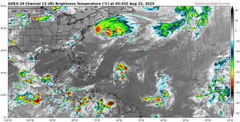
N2FSU wrote:otowntiger wrote:skillz305 wrote:Spaghettis getting interesting on 99L
Can you share an image?
https://uploads.tapatalk-cdn.com/20250822/fcf4e1307e9efd031a139410b34821fb.jpg
Sent from my iPad using Tapatalk

TomballEd wrote:Not a ton of ensemble support, but there are a few members. It stays weak, it doesn't recurve. Interesting Euro 0Z that smacks SE Louisiana a week from Wednesday but one run of 50 doesn't mean much 13 days out.
It is sure to change but some of the 0 and 6Z ensembles showing if it is a late bloomer it may stay S of the Gulf.
Eyeballing vis satellite, it defintely has rotation but using lat/long lines, I don't think there are W winds S of the center. When is the next sensor pass? Been outperforming the models so far, I think more ensembles might start seeing generation in the Caribbean in the next couple of days


AnnularCane wrote:If they think it might develop more in the future, I wonder why they don't just decrease the 2-day and leave the 7-day alone.
TampaWxLurker wrote:Apparently this is the ultimate "we don't want to waste a name" storm.
Maybe they want to make up for wasting a name on Andrea and Barry and conserve the names for later. Let it get reclassified as a TS in post-season analysis.
kevin wrote:N2FSU wrote:otowntiger wrote: Can you share an image?
https://uploads.tapatalk-cdn.com/20250822/fcf4e1307e9efd031a139410b34821fb.jpg
Sent from my iPad using Tapatalk
Definitely not the kind of track you want to see. The big IF seems to be whether this forms at all (or reforms in the ECar).
syfr wrote:kevin wrote:N2FSU wrote:https://uploads.tapatalk-cdn.com/20250822/fcf4e1307e9efd031a139410b34821fb.jpg
Sent from my iPad using Tapatalk
Definitely not the kind of track you want to see. The big IF seems to be whether this forms at all (or reforms in the ECar).
"It'll go somewhere"


Users browsing this forum: No registered users and 185 guests


