ATL: Ex INVEST 99L - Discussion
Moderator: S2k Moderators
-
hurricane2025
- Category 1

- Posts: 254
- Joined: Thu Apr 08, 2021 10:36 am
-
StormWeather

- Category 1
- Posts: 475
- Joined: Wed Jun 05, 2024 2:34 pm
Re: ATL: INVEST 99L - Discussion (10/20)
hurricane2025 wrote:More like Harvey treatment
Yeah, I don’t think I want that.
1 likes
Just an average cyclone tracker
The posts in this forum are NOT official forecasts and should not be used as such. They are just the opinion of the poster and may or may not be backed by sound meteorological data. They are NOT endorsed by any professional institution or storm2k.org. For official information, please refer to the NHC and NWS products
The posts in this forum are NOT official forecasts and should not be used as such. They are just the opinion of the poster and may or may not be backed by sound meteorological data. They are NOT endorsed by any professional institution or storm2k.org. For official information, please refer to the NHC and NWS products
-
Sciencerocks
- Category 5

- Posts: 10181
- Age: 40
- Joined: Thu Jul 06, 2017 1:51 am
Re: ATL: INVEST 99L - Discussion (10/20)

Starting to reform its LLC under the convection and sustaining convection.
0 likes
-
Stratton23
- Category 5
- Posts: 3525
- Joined: Fri Jul 21, 2023 10:59 pm
- Location: Katy, Tx
Re: ATL: INVEST 99L - Discussion (10/20)
Sciencerocks it really is amazing how 99L has basically given a middle finger to the hostile environment that its in, its putting up one heck of a fight
4 likes
Re: ATL: INVEST 99L - Discussion (10/20)
Some waves are just built differently, especially with how 99L has defied its modeled demise since it left Africa. Reminds me of Oscar last year, where models were writing it off as a doomed wave and the NHC downgraded it to a 10/20 lemon two days before it became a surprise hurricane that no one expected. You can never take your eyes off some CV seeds, especially one as resilient as this one - they can take off quickly once they find themselves in favorable conditions.
1 likes

Re: ATL: INVEST 99L - Discussion (10/20)
Stratton23 wrote:Sciencerocks it really is amazing how 99L has basically given a middle finger to the hostile environment that its in, its putting up one heck of a fight
Stratton I know it’s heading towards the graveyard but what does the environment look like ahead of it?
1 likes
-
Stratton23
- Category 5
- Posts: 3525
- Joined: Fri Jul 21, 2023 10:59 pm
- Location: Katy, Tx
Re: ATL: INVEST 99L - Discussion (10/20)
LAF92 environment near the leeward islands looks slightly less hostile than what its currently in, I have a hinch this will be a TD right as it gets to the islands, then obviously the eastern caribbean will be unfavorable, but actually not because of shear, its really the fast trade winds that this will have to contend with, but the thing to watch here is once it gets west of jamaica, thats my magical vertical line i like to use, past jamaica thats when the trade winds really slow down, so if 99L can hold together and maintain its vigorous LLC, the western caribbean looks pretty decent in terms of an environment for this to develop in, shear is low too
3 likes
-
Stratton23
- Category 5
- Posts: 3525
- Joined: Fri Jul 21, 2023 10:59 pm
- Location: Katy, Tx
Re: ATL: INVEST 99L - Discussion (20/20)
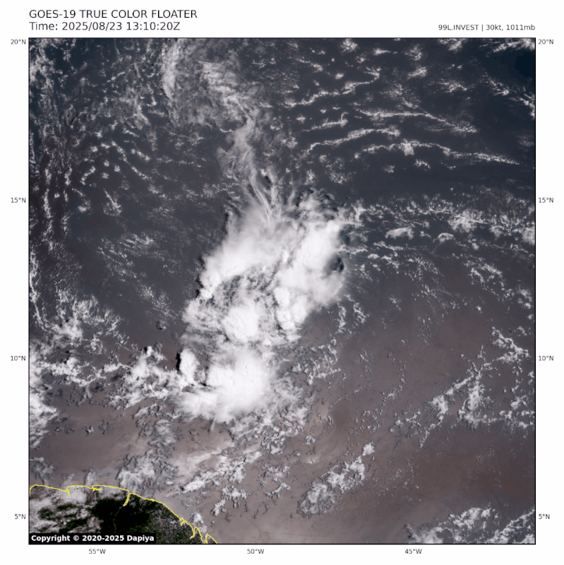
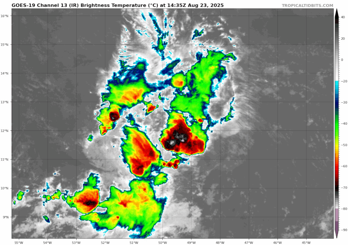
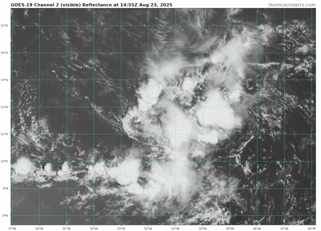
Thats some really vigorous convection, especially when you start seeing those brighter pink shades showing up
0 likes
Re: ATL: INVEST 99L - Discussion (20/20)
Stratton23 wrote:Thats some really vigorous convection, especially when you start seeing those brighter pink shades showing up
Yeah, surprising given the dry environment it is in, which is one of the reasons why models kill this system. Today was supposed to be a really unfavorable day, so it's definitely putting up a fight.
4 likes
-
Category5Kaiju

- Category 5
- Posts: 4331
- Joined: Thu Dec 24, 2020 12:45 pm
- Location: Seattle and Phoenix
Re: ATL: INVEST 99L - Discussion (20/20)
At least visually, 99L really looks to be fighting quite well against the hostile background state. In a sense, it vaguely reminds me of Dorian during its time in the MDR as a minimal tropical storm, where it kept traveling while pulsating in an area with high levels of dry air and shear. Not to mention, back during Dorian's very early stages, model support for its future was tepid at best, with many calling for it to dissipate outright in the Caribbean.
I'm not saying that 99L will end up as anything close to Dorian, but Dorian serves as a cautionary tale that allegedly "screwed" waves or storms can become dangerous if they survive long enough that they manage to reach even a pocket of favorable conditions, closer to land.
I'm not saying that 99L will end up as anything close to Dorian, but Dorian serves as a cautionary tale that allegedly "screwed" waves or storms can become dangerous if they survive long enough that they manage to reach even a pocket of favorable conditions, closer to land.
3 likes
Unless explicitly stated, all info in my posts is based on my own opinions and observations. Tropical storms and hurricanes can be extremely dangerous. Refer to an accredited weather research agency or meteorologist if you need to make serious decisions regarding an approaching storm.
-
cycloneye

- Admin

- Posts: 149278
- Age: 69
- Joined: Thu Oct 10, 2002 10:54 am
- Location: San Juan, Puerto Rico
Re: ATL: INVEST 99L - Discussion (20/20)
East of the Windward Islands (AL99):
Showers and thunderstorms continue in association with a tropical
wave located about 650 miles east of the Windward Islands. Some
development of this system could occur during the next couple of
days while the system moves quickly westward at about 20 to 25 mph.
Locally heavy rainfall and gusty winds are possible across portions
of the Windward Islands as the system moves through on Sunday and
Monday. By Tuesday, conditions over the central Caribbean are
expected to be unfavorable for further development.
* Formation chance through 48 hours...low...20 percent.
* Formation chance through 7 days...low...20 percent.
0 likes
Visit the Caribbean-Central America Weather Thread where you can find at first post web cams,radars
and observations from Caribbean basin members Click Here
and observations from Caribbean basin members Click Here
-
REDHurricane

- Category 1
- Posts: 438
- Age: 28
- Joined: Sun Jul 03, 2022 2:36 pm
- Location: Northeast Pacific Ocean
Re: ATL: INVEST 99L - Discussion (10/20)
Stratton23 wrote:LAF92 environment near the leeward islands looks slightly less hostile than what its currently in, I have a hinch this will be a TD right as it gets to the islands, then obviously the eastern caribbean will be unfavorable, but actually not because of shear, its really the fast trade winds that this will have to contend with, but the thing to watch here is once it gets west of jamaica, thats my magical vertical line i like to use, past jamaica thats when the trade winds really slow down, so if 99L can hold together and maintain its vigorous LLC, the western caribbean looks pretty decent in terms of an environment for this to develop in, shear is low too
Yep, I've got a bit of a feeling about this one for this reason. ICON has been showing the exact same scenario for the past several runs now and at this point I have no reason to not trust it more than the other models, especially given that we've seen a similar pattern play out multiple times (Ian, Ida, Harvey, Dorian, probably others too) just in the past decade with these tropical waves that don't develop much in the MDR but stay intact through the eastern Caribbean and find a sweet spot to take off once they reach the western Caribbean/GoM. Of course it's still way too early to put very much stock into any particular model run, but I think people should definitely pay attention to this one over the next few days at least
1 likes


Re: ATL: INVEST 99L - Discussion (20/30)
AnnularCane wrote:If they think it might develop more in the future, I wonder why they don't just decrease the 2-day and leave the 7-day alone.
At the risk of sounding pedantic and snooty, as you may know, may, could and might don't necessarily convey the same meaning (despite often being used interchangeably in casual conversation). Now, for the benefit of those ignorant of the differences but feeling too lazy to google the comparison for themselves
Now, the 8 AM Tropical Weather Outlook (TWO) actually states (in part), "Some development of this system could occur during the next few days while the system moves quickly westward..." and (considering that, as stated at the link, there's disagreement among many native anglophones about when to use which word) the only real clue available to us on what NHC thinks about the likelihood cyclogenesis occurring within 7 days' time is contained in the TWO itself, at the end.
Just my two cents.
0 likes


Re: ATL: INVEST 99L - Discussion (20/20)
It wouldn't be the first time a vortex has survived strong shear. The wind shear can often times drive convection through venting if it is not forcing entrainment of dry air. The shear vector right now is from the South which is high TPW air from the Amazon.

2 likes
Re: ATL: INVEST 99L - Discussion (20/20)
Hopefully we get a timely ASCAT pass tonight. This is getting close to the islands, and with how poorly a lot of models have been with handling this system, a last minute surprise is not something we want.
2 likes
-
weeniepatrol

- Category 5
- Posts: 1341
- Joined: Sat Aug 22, 2020 5:30 pm
- Location: WA State

-
tropicwatch

- Category 5
- Posts: 3426
- Age: 62
- Joined: Sat Jun 02, 2007 10:01 am
- Location: Panama City Florida
- Contact:
Re: ATL: INVEST 99L - Discussion (20/20)
Nice flare up of convection, Vorticity appears to be increasing and stacked 925-700mb level. If this continues, I would think development chances would increase significantly.
1 likes
Tropicwatch
Agnes 72', Eloise 75, Elena 85', Kate 85', Charley 86', Florence 88', Beryl 94', Dean 95', Erin 95', Opal 95', Earl 98', Georges 98', Ivan 2004', Arlene 2005', Dennis 2005', Ida 2009' Debby 2012' Irma 2017' Michael 2018'
Agnes 72', Eloise 75, Elena 85', Kate 85', Charley 86', Florence 88', Beryl 94', Dean 95', Erin 95', Opal 95', Earl 98', Georges 98', Ivan 2004', Arlene 2005', Dennis 2005', Ida 2009' Debby 2012' Irma 2017' Michael 2018'
Who is online
Users browsing this forum: No registered users and 149 guests