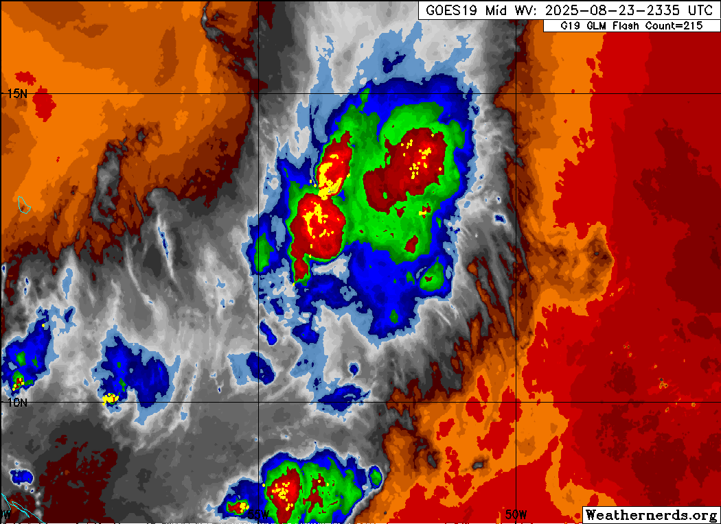
ATL: Ex INVEST 99L - Discussion

Moderator: S2k Moderators

Message
Author
User avatar
AJC3
Admin
Admin
Posts: 4059
Age: 61
Joined: Tue Aug 31, 2004 7:04 pm
Location: Ballston Spa, New York
Contact:

Re: ATL: INVEST 99L - Discussion (40/40)

#161 Postby AJC3 » Sat Aug 23, 2025 9:25 pm

StormWeather wrote:
wzrgirl1 wrote:
abajan wrote:0Z Best Track:
AL, 99, 2025082400, , BEST, 0, 121N, 521W, 35, 1010, DB


Whoa mama!


Does this mean that this will be declared a tropical depression at 11 o’clock?

No circulation exists.

No circulation = no TC


Exactly. One point to be made is that the fact that the disturbance is currently BT'd as having 35kt winds increases the chance that this would be designated as a PTC, since it would be more likely to produce TS conditions in the Lesser Antilles. That way, it would allow NHC to issue Watches/Warnings for TS conditions.
7 likes   

User avatar
StormWeather
Category 1
Category 1
Posts: 366
Joined: Wed Jun 05, 2024 2:34 pm

Re: ATL: INVEST 99L - Discussion (40/40)

#162 Postby StormWeather » Sat Aug 23, 2025 9:34 pm

AJC3 wrote:
StormWeather wrote:
wzrgirl1 wrote:
Does this mean that this will be declared a tropical depression at 11 o’clock?

No circulation exists.

No circulation = no TC


Exactly. One point to be made is that the fact that the disturbance is currently BT'd as having 35kt winds increases the chance that this would be designated as a PTC, since it would be more likely to produce TS conditions in the Lesser Antilles. That way, it would allow NHC to issue Watches/Warnings for TS conditions.

Yeah, I could see PTC advisories initiated at 11 pm. Definitely fits the criteria. I think early this season before the season started the NHC changed the hours in advance of TS conditions being anticipated and putting out advisories from 48 hours to 72 hours. That means even more extended lead time.
3 likes   
Just an average cyclone tracker

The posts in this forum are NOT official forecasts and should not be used as such. They are just the opinion of the poster and may or may not be backed by sound meteorological data. They are NOT endorsed by any professional institution or storm2k.org. For official information, please refer to the NHC and NWS products

BobHarlem
Category 5
Category 5
Posts: 2427
Joined: Thu Oct 20, 2005 6:11 pm

Re: ATL: INVEST 99L - Discussion (40/40)

#163 Postby BobHarlem » Sat Aug 23, 2025 10:04 pm

Looking here I don't see the NHC really doing anything with this until recon is out there, if then. Probably will keep it at 40% overnight.

Image
0 likes   

User avatar
eastcoastFL
Category 5
Category 5
Posts: 3936
Age: 43
Joined: Thu Apr 12, 2007 12:29 pm
Location: Palm City, FL

Re: ATL: INVEST 99L - Discussion (40/40)

#164 Postby eastcoastFL » Sat Aug 23, 2025 10:13 pm

BobHarlem wrote:Looking here I don't see the NHC really doing anything with this until recon is out there, if then. Probably will keep it at 40% overnight.

https://i.postimg.cc/LXYjTWbV/15281184.gif


I don't see much there for the NHC to write about. An elongated wave axis with no real circulation. Still just a strong wave with potential to be more down the road.
0 likes   
Personal Forecast Disclaimer:
The posts in this forum are NOT official forecast and should not be used as such. They are just the opinion of the poster and may or may not be backed by sound meteorological data. They are NOT endorsed by any professional institution or storm2k.org. For official information, please refer to the NHC and NWS products.

User avatar
Woofde
Category 2
Category 2
Posts: 528
Joined: Tue Jul 06, 2021 11:33 am

Re: ATL: INVEST 99L - Discussion (40/40)

#165 Postby Woofde » Sat Aug 23, 2025 10:23 pm

StormWeather wrote:
wzrgirl1 wrote:
abajan wrote:0Z Best Track:
AL, 99, 2025082400, , BEST, 0, 121N, 521W, 35, 1010, DB


Whoa mama!


Does this mean that this will be declared a tropical depression at 11 o’clock?

No circulation exists.

No circulation = no TC
Yeah, it's still a bit messy at the moment. The shear isn't killing it, but it will still be difficult to consolidate a circulation under these conditions.

The tenacity of this wave is really admirable though. When you read the genesis outlooks for this guy over the past week they are harsh. One would've thought it should've long poofed by now, but it's still here kicking.
3 likes   

User avatar
abajan
S2K Supporter
S2K Supporter
Posts: 4280
Age: 61
Joined: Sun Sep 07, 2003 5:10 am
Location: Barbados

Re: ATL: INVEST 99L - Discussion (40/40)

#166 Postby abajan » Sun Aug 24, 2025 2:39 am

6Z Best Track:
AL, 99, 2025082406, , BEST, 0, 123N, 541W, 35, 1010, DB...
0 likes   

Weatherwatcher2018
Tropical Depression
Tropical Depression
Posts: 82
Joined: Wed Sep 26, 2018 4:30 pm

Re: ATL: INVEST 99L - Discussion (40/40)

#167 Postby Weatherwatcher2018 » Sun Aug 24, 2025 5:57 am

Do you think it will be upgraded this morning
0 likes   

User avatar
Ubuntwo
Category 5
Category 5
Posts: 1411
Age: 31
Joined: Thu Oct 05, 2017 10:41 pm

Re: ATL: INVEST 99L - Discussion (40/40)

#168 Postby Ubuntwo » Sun Aug 24, 2025 6:01 am

Weatherwatcher2018 wrote:Do you think it will be upgraded this morning

Not this morning - there is no evidence of a closed circulation at the moment. If it is upgraded today, it will be in the evening dependent on recon findings.
0 likes   
Kendall -> SLO -> PBC

Memorable Storms: Katrina (for its Florida landfall...) Wilma Matthew Irma

BobHarlem
Category 5
Category 5
Posts: 2427
Joined: Thu Oct 20, 2005 6:11 pm

Re: ATL: INVEST 99L - Discussion (40/40)

#169 Postby BobHarlem » Sun Aug 24, 2025 6:42 am

Weatherwatcher2018 wrote:Do you think it will be upgraded this morning

No chance, LLC isn't there.

from the 8am outlook:

East of the Windward Islands (AL99):
Showers and thunderstorms associated with a tropical wave located
about 200 miles east of the Windward Islands have increased since
yesterday. However, the wave does not appear to have a surface
circulation. This system could still become a tropical depression
during the next day or two while it moves quickly westward at about
20 to 25 mph, passing through the Windward and Leeward Islands
later today and early Monday. Regardless of development, locally
heavy rainfall and gusty winds are likely across portions of the
Windward and Leeward Islands today and Monday. The system is
expected to reach the central Caribbean Sea on Tuesday, where
conditions are forecast to become less favorable for additional
development. An Air Force reconnaissance aircraft is scheduled to
investigate the system this afternoon, if necessary.
* Formation chance through 48 hours...medium...40 percent.
* Formation chance through 7 days...medium...40 percent.


-
They are basically waiting on recon. If I were to take a guess right now I doubt it gets upgraded at all, but I think recon will be there at a good time to make sure. Mid levels fairly healthy. It is showing up now on Barbados radar.
Image

Image

Barbados weather radar https://www.barbadosweather.org/Radars/ ... oducts.php

Cyclonixwx tries to get something here on radar too https://cyclonicwx.com/storms/al99/
2 likes   

Cachondo23
Tropical Storm
Tropical Storm
Posts: 113
Joined: Wed May 25, 2022 5:56 am

Re: ATL: INVEST 99L - Discussion (40/40)

#170 Postby Cachondo23 » Sun Aug 24, 2025 7:16 am

Can the NHC initiate a PTC for a wave with 40% of development?
0 likes   

TallyTracker
Category 2
Category 2
Posts: 761
Joined: Thu Oct 11, 2018 2:46 pm

Re: ATL: INVEST 99L - Discussion (40/40)

#171 Postby TallyTracker » Sun Aug 24, 2025 7:21 am

We’ve seen waves with 50 kt (60 mph) sustained winds before that struggled to develop a closed circulation in the MDR and Caribbean.

Hurricane Dolly in 2008 is a great example as the circulation was not well defined until the western Caribbean but still hit Texas as a hurricane. The storm had TS winds for much of it’s trek across the Caribbean.
1 likes   
Fran '96, Georges '98, Gordon '00, Gabrielle '01, Charley '04, Frances '04, Jeanne '04, Barry '07, Fay '08, Debby '12, Matthew '16, Emily '17, Irma '17, Michael ‘18, Elsa ‘21, Fred ‘21, Mindy ‘21, Nicole ‘22, Idalia ‘23, Debby ‘24, Helene ‘24

BobHarlem
Category 5
Category 5
Posts: 2427
Joined: Thu Oct 20, 2005 6:11 pm

Re: ATL: INVEST 99L - Discussion (40/40)

#172 Postby BobHarlem » Sun Aug 24, 2025 7:26 am

Cachondo23 wrote:Can the NHC initiate a PTC for a wave with 40% of development?

Can they? yeah, will they? not with this, it just doesn't qualify. (See Erin in the Cabo Verde) I wouldn't be shocked to see it get all the way to central America in this half baked state and never develop.
Last edited by BobHarlem on Sun Aug 24, 2025 8:43 am, edited 1 time in total.
0 likes   

DunedinDave
Category 1
Category 1
Posts: 268
Joined: Fri Aug 25, 2023 10:31 am

Re: ATL: INVEST 99L - Discussion (40/40)

#173 Postby DunedinDave » Sun Aug 24, 2025 7:42 am

It’s really motoring. Moving very fast. I just wonder if it is moving too fast to 1) develop and 2) Turn. Feels like this we’ve seen this song and dance before with “speedboat storms” heading into the Caribbean that crash right into CA. Obviously models are showing this right now.
1 likes   

User avatar
Kingarabian
S2K Supporter
S2K Supporter
Posts: 16209
Joined: Sat Aug 08, 2009 3:06 am
Location: Honolulu, Hawaii

Re: ATL: INVEST 99L - Discussion (40/40)

#174 Postby Kingarabian » Sun Aug 24, 2025 8:31 am

How it looks when it reaches the vicinity of Jamaica is key. If it remains this robust, it could slow down and gradually track WNW. That opens the door for development near the Yucatan.
0 likes   
RIP Kobe Bryant

User avatar
Kingarabian
S2K Supporter
S2K Supporter
Posts: 16209
Joined: Sat Aug 08, 2009 3:06 am
Location: Honolulu, Hawaii

Re: ATL: INVEST 99L - Discussion (40/40)

#175 Postby Kingarabian » Sun Aug 24, 2025 8:34 am

The models have been killing this off prematurely all last week. Now they're keeping it coherent until it passes the windward islands, then forecast its vorticity to fracture thus allowing it to crash into Central America.
0 likes   
RIP Kobe Bryant

TampaWxLurker
Tropical Storm
Tropical Storm
Posts: 177
Joined: Thu Aug 01, 2024 8:20 am

Re: ATL: INVEST 99L - Discussion (40/40)

#176 Postby TampaWxLurker » Sun Aug 24, 2025 8:38 am

Moving too quickly west for its own good. Can't get any time to consolidate.
0 likes   

Weathertracker96
Tropical Storm
Tropical Storm
Posts: 123
Joined: Mon Oct 16, 2023 3:41 pm

Re: ATL: INVEST 99L - Discussion (40/40)

#177 Postby Weathertracker96 » Sun Aug 24, 2025 8:40 am

Kingarabian wrote:The models have been killing this off prematurely all last week. Now they're keeping it coherent until it passes the windward islands, then forecast its vorticity to fracture thus allowing it to crash into Central America.


I agree with you. It’s best to watch this in real time. It’s not even supposed to be here according to the models all last week. It’s a persistent wave.
3 likes   

User avatar
Nimbus
Category 5
Category 5
Posts: 5368
Joined: Mon Jul 19, 2004 10:54 am

Re: ATL: INVEST 99L - Discussion (40/40)

#178 Postby Nimbus » Sun Aug 24, 2025 9:03 am

Kingarabian wrote:How it looks when it reaches the vicinity of Jamaica is key. If it remains this robust, it could slow down and gradually track WNW. That opens the door for development near the Yucatan.


NHC said this was tracking west at between 20 and 25 mph till about Jamaica.
Forward speed like that makes it tougher to detect a west wind at the least.
Which end of the wave will close off?
There is about 4 degrees of latitude there, I can't see the apex of the wave at the moment.
0 likes   

TomballEd
Category 4
Category 4
Posts: 950
Age: 61
Joined: Wed Aug 16, 2023 4:52 pm
Location: Spring/Klein area, not Tomball

Re: ATL: INVEST 99L - Discussion (40/40)

#179 Postby TomballEd » Sun Aug 24, 2025 10:43 am

Nimbus wrote:
Kingarabian wrote:How it looks when it reaches the vicinity of Jamaica is key. If it remains this robust, it could slow down and gradually track WNW. That opens the door for development near the Yucatan.


NHC said this was tracking west at between 20 and 25 mph till about Jamaica.
Forward speed like that makes it tougher to detect a west wind at the least.
Which end of the wave will close off?
There is about 4 degrees of latitude there, I can't see the apex of the wave at the moment.


The fast speed also increases shear *and* reduces low level convergence. Plenty of upper divergence, not much low level convergence. I think recon is flying, I am surprised, I see no evidence of a closed low on vis satellite.

Image

Image
1 likes   

zhukm29
Category 1
Category 1
Posts: 306
Joined: Tue Aug 28, 2018 2:37 pm

Re: ATL: INVEST 99L - Discussion (40/40)

#180 Postby zhukm29 » Sun Aug 24, 2025 10:47 am

Interesting thread by meteorologist Yaakov Cantor about how the short term organization of 99L now could affect how conditions will be like in the Western Caribbean. A more organized 99L could spell trouble later on.
 https://x.com/yconsor/status/1959526535108382799


Apparently 99L might have a small closed circulation already? Luckily we have recon today to and investigate - if it can find a LLC, this will likely jump straight to Gabrielle given it already has 35kt winds. ASCAT does have lower resolution, and we've have cases before where ASCAT showed a wave but recon found a LLC (e.g., Nana 2020 is a good example when it was designated; it had a LLC that was not reflected on ASCAT due to its small size and fast forward speed). We've also seen a lot of short lived spin-ups in this area in previous seasons, so I don't think anyone can take their eyes off of this wave, especially with how persistent it is. I do think the window of opportunity for 99L to claim a name is closing though as it enters the Eastern Caribbean graveyard, at least in the short term.
 https://x.com/yconsor/status/1959529674175897818

4 likes   


Return to “2025”

Who is online

Users browsing this forum: No registered users and 58 guests