Area of interest in the Eastern Atlantic (0/30)

This is the general tropical discussion area. Anyone can take their shot at predicting a storms path.

Moderator: S2k Moderators

Forum rules

The posts in this forum are NOT official forecasts and should not be used as such. They are just the opinion of the poster and may or may not be backed by sound meteorological data. They are NOT endorsed by any professional institution or STORM2K. For official information, please refer to products from the National Hurricane Center and National Weather Service.

Help Support Storm2K
Message
Author
User avatar
kevin
Category 5
Category 5
Posts: 2658
Age: 26
Joined: Wed Aug 28, 2019 4:35 am

Area of interest in the Eastern Atlantic (0/30)

#1 Postby kevin » Thu Aug 28, 2025 2:09 am

We have a lemon.

Tropical Weather Outlook
NWS National Hurricane Center Miami FL
200 AM EDT Thu Aug 28 2025

1. Eastern Tropical Atlantic:
A tropical wave is forecast to emerge off the west coast of Africa
by this weekend to the south of the Cabo Verde Islands. Thereafter,
environmental conditions appear favorable for some slow development
of this system as it moves westward to west-northwestward at 15 to
20 mph, moving across the eastern into central Tropical Atlantic
through the middle of next week.
* Formation chance through 48 hours...low...near 0 percent.
* Formation chance through 7 days...low...20 percent.


Image
0 likes   

User avatar
kevin
Category 5
Category 5
Posts: 2658
Age: 26
Joined: Wed Aug 28, 2019 4:35 am

Re: Area of interest in the Eastern Atlantic (0/20)

#2 Postby kevin » Thu Aug 28, 2025 2:13 am

There's definitely support from the Euro with about 40% of the members developing this.

Image

GEFS on the other hand has pretty much nothing.

Image
5 likes   

User avatar
cycloneye
Admin
Admin
Posts: 146346
Age: 69
Joined: Thu Oct 10, 2002 10:54 am
Location: San Juan, Puerto Rico

Re: Area of interest in the Eastern Atlantic (0/20)

#3 Postby cycloneye » Thu Aug 28, 2025 6:41 am

Tropical Weather Outlook
NWS National Hurricane Center Miami FL
800 AM EDT Thu Aug 28 2025

For the North Atlantic...Caribbean Sea and the Gulf of America:

Active Systems:
The National Hurricane Center has issued the last advisory on
Post-Tropical Cyclone Fernand, located over the central Atlantic.

1. Eastern Tropical Atlantic:
A tropical wave is forecast to emerge off the west coast of Africa
on Sunday. Thereafter, environmental conditions could support some
slow development of this system while it moves westward to
west-northwestward at 15 to 20 mph, moving across the eastern and
central tropical Atlantic next week.
* Formation chance through 48 hours...low...near 0 percent.
* Formation chance through 7 days...low...20 percent.


Forecaster Cangialosi
0 likes   
Visit the Caribbean-Central America Weather Thread where you can find at first post web cams,radars
and observations from Caribbean basin members Click Here

User avatar
StormWeather
Category 1
Category 1
Posts: 322
Joined: Wed Jun 05, 2024 2:34 pm

Re: Area of interest in the Eastern Atlantic (0/20)

#4 Postby StormWeather » Thu Aug 28, 2025 6:44 am

kevin wrote:There's definitely support from the Euro with about 40% of the members developing this.

https://i.imgur.com/0vBR0LG.png

GEFS on the other hand has pretty much nothing.

https://i.imgur.com/cOebJ3b.png

Seems like the classic EURO vs GFS on this one.
0 likes   
Just an average cyclone tracker

The posts in this forum are NOT official forecasts and should not be used as such. They are just the opinion of the poster and may or may not be backed by sound meteorological data. They are NOT endorsed by any professional institution or storm2k.org. For official information, please refer to the NHC and NWS products

LarryWx
S2K Supporter
S2K Supporter
Posts: 6508
Joined: Sun Sep 07, 2003 2:04 pm
Location: GA

Re: Area of interest in the Eastern Atlantic (0/20)

#5 Postby LarryWx » Thu Aug 28, 2025 7:24 am

Though support has waned significantly among the ops since all but the GFS had it on Monday, the 0Z UKMET brought the E MDR AEW back from the dead (albeit with later TCG) with a minimal TS due to a strong pressure gradient below a rather strong Azores high moving WNW:

NEW TROPICAL CYCLONE FORECAST TO DEVELOP AFTER 156 HOURS
FORECAST POSITION AT T+156 : 15.6N 33.8W

LEAD CENTRAL MAXIMUM WIND
VERIFYING TIME TIME POSITION PRESSURE (MB) SPEED (KNOTS)
-------------- ---- -------- ------------- -------------
1200UTC 03.09.2025 156 15.6N 33.8W 1010 34
0000UTC 04.09.2025 168 16.9N 35.9W 1011 35


But the latest GFS/Icon/CMC/Euro have no more than a weak reflection at the sfc. Yesterday’s 12Z JMA had close to a TD but it didn’t develop further and weakens.

If this were to develop, it like Erin due to latitude would be a good recurve safely candidate from the US as of the current model consensus of steering fwiw but a long ways to go to determine that likelihood with confidence if it were to actually develop.

Some EPS members develop this, especially on yesterday’s 12Z (as Kevin just posted) and today’s 6Z, but the GEFS is very quiet, however, as he noted.
1 likes   
Personal Forecast Disclaimer:
The posts in this forum are NOT official forecasts and should not be used as such. They are just the opinion of the poster and may or may not be backed by sound meteorological data. They are NOT endorsed by any professional institution or storm2k.org. For official information, please refer to the NHC and NWS products.

User avatar
GCANE
S2K Supporter
S2K Supporter
Posts: 11640
Joined: Mon Oct 22, 2007 8:03 am

Re: Area of interest in the Eastern Atlantic (0/20)

#6 Postby GCANE » Thu Aug 28, 2025 7:27 am

I doubt this has a chance to develop - SAL looks as strong as ever.
0 likes   

User avatar
GCANE
S2K Supporter
S2K Supporter
Posts: 11640
Joined: Mon Oct 22, 2007 8:03 am

Re: Area of interest in the Eastern Atlantic (0/20)

#7 Postby GCANE » Thu Aug 28, 2025 8:24 am

06Z 8/28 GFS initializes a 1016mb surface low at 8N 45W
Models not developing it and may run into South America but you never know.
I all honesty, I haven't seen any improvement in the models this year.
0 likes   

User avatar
DorkyMcDorkface
Category 4
Category 4
Posts: 916
Age: 27
Joined: Mon Sep 30, 2019 1:32 pm
Location: Mid-Atlantic

Re: Area of interest in the Eastern Atlantic (0/20)

#8 Postby DorkyMcDorkface » Thu Aug 28, 2025 8:59 am

GCANE wrote:I doubt this has a chance to develop - SAL looks as strong as ever.

Ehh, at the moment the SAL actually doesn't look very potent. Honestly right now I'd be more concerened about interaction with a potential TUTT spurred by the EPAC TC outbreak (something Andy Hazelton mentioned in a Tweet I shared in the indicators thread) as far as adverse conditions are concerned.
Image
1 likes   
Please note the thougths expressed by this account are solely those of the user and are from a hobbyist perspective. For more comprehensive analysis, consult an actual professional meteorologist or meteorology agency.


Floyd 1999 | Isabel 2003 | Hanna 2008 | Irene 2011 | Sandy 2012 | Isaias 2020

User avatar
DorkyMcDorkface
Category 4
Category 4
Posts: 916
Age: 27
Joined: Mon Sep 30, 2019 1:32 pm
Location: Mid-Atlantic

Re: Area of interest in the Eastern Atlantic (0/20)

#9 Postby DorkyMcDorkface » Thu Aug 28, 2025 9:36 am

LarryWx wrote:Though support has waned significantly among the ops since all but the GFS had it on Monday, the 0Z UKMET brought the E MDR AEW back from the dead (albeit with later TCG) with a minimal TS due to a strong pressure gradient below a rather strong Azores high moving WNW:

NEW TROPICAL CYCLONE FORECAST TO DEVELOP AFTER 156 HOURS
FORECAST POSITION AT T+156 : 15.6N 33.8W

LEAD CENTRAL MAXIMUM WIND
VERIFYING TIME TIME POSITION PRESSURE (MB) SPEED (KNOTS)
-------------- ---- -------- ------------- -------------
1200UTC 03.09.2025 156 15.6N 33.8W 1010 34
0000UTC 04.09.2025 168 16.9N 35.9W 1011 35


But the latest GFS/Icon/CMC/Euro have no more than a weak reflection at the sfc. Yesterday’s 12Z JMA had close to a TD but it didn’t develop further and weakens.

If this were to develop, it like Erin due to latitude would be a good recurve safely candidate from the US as of the current model consensus of steering fwiw but a long ways to go to determine that likelihood with confidence if it were to actually develop.

Some EPS members develop this, especially on yesterday’s 12Z (as Kevin just posted) and today’s 6Z, but the GEFS is very quiet, however, as he noted.

Wondering if the bullishness of Google Deepmind contributed to the NHC's decision to highlight it despite deterministic guidance elsewhere showing very little. They seem to be factoring it into their forecasts given they've mentioned it in several TCDs this year.

Image
Image
3 likes   

Please note the thougths expressed by this account are solely those of the user and are from a hobbyist perspective. For more comprehensive analysis, consult an actual professional meteorologist or meteorology agency.


Floyd 1999 | Isabel 2003 | Hanna 2008 | Irene 2011 | Sandy 2012 | Isaias 2020

TomballEd
Category 3
Category 3
Posts: 870
Age: 61
Joined: Wed Aug 16, 2023 4:52 pm
Location: Spring/Klein area, not Tomball

Re: Area of interest in the Eastern Atlantic (0/20)

#10 Postby TomballEd » Thu Aug 28, 2025 9:54 am

6Z Euro family suggests early development would mean an almost certain recurve. A tick N gets it into lower shear. Moisture isn't great anywhere near where this should be coming off based on GFS op forecast.


The scary solutions for land interactions would be an undeveloped wave cruising west. Not sure it is the AOI, but a couple of lows develop on the GFS ensembles after 12 days which may be from a weak wave cruising W.
1 likes   

LarryWx
S2K Supporter
S2K Supporter
Posts: 6508
Joined: Sun Sep 07, 2003 2:04 pm
Location: GA

Re: Area of interest in the Eastern Atlantic (0/20)

#11 Postby LarryWx » Thu Aug 28, 2025 11:48 am

12Z UKMET: has a TS that is already recurving before 40:

NEW TROPICAL CYCLONE FORECAST TO DEVELOP AFTER 138 HOURS
FORECAST POSITION AT T+138 : 15.3N 32.1W

LEAD CENTRAL MAXIMUM WIND
VERIFYING TIME TIME POSITION PRESSURE (MB) SPEED (KNOTS)
-------------- ---- -------- ------------- -------------
1200UTC 03.09.2025 144 16.0N 33.0W 1010 37
0000UTC 04.09.2025 156 16.9N 35.4W 1010 40
1200UTC 04.09.2025 168 18.6N 37.0W 1010 38
0 likes   
Personal Forecast Disclaimer:
The posts in this forum are NOT official forecasts and should not be used as such. They are just the opinion of the poster and may or may not be backed by sound meteorological data. They are NOT endorsed by any professional institution or storm2k.org. For official information, please refer to the NHC and NWS products.

User avatar
DorkyMcDorkface
Category 4
Category 4
Posts: 916
Age: 27
Joined: Mon Sep 30, 2019 1:32 pm
Location: Mid-Atlantic

Re: Area of interest in the Eastern Atlantic (0/20)

#12 Postby DorkyMcDorkface » Thu Aug 28, 2025 11:53 am

GFS and CMC on board this afternoon. Wildly different scenarios though, GFS has it blowing up into a hurricane in the subtropics while the CMC has a brief TS right off the African coast/near CV that weakens dramatically as it tracks W
Image
Image
1 likes   

Please note the thougths expressed by this account are solely those of the user and are from a hobbyist perspective. For more comprehensive analysis, consult an actual professional meteorologist or meteorology agency.


Floyd 1999 | Isabel 2003 | Hanna 2008 | Irene 2011 | Sandy 2012 | Isaias 2020

User avatar
cycloneye
Admin
Admin
Posts: 146346
Age: 69
Joined: Thu Oct 10, 2002 10:54 am
Location: San Juan, Puerto Rico

Re: Area of interest in the Eastern Atlantic (0/20)

#13 Postby cycloneye » Thu Aug 28, 2025 12:04 pm

Almost like a Florence type track. Edit=Eventually it recurves east of Bermuda.

Now we await the Euro and it's ensembles to see what they have.

Image

Image
0 likes   
Visit the Caribbean-Central America Weather Thread where you can find at first post web cams,radars
and observations from Caribbean basin members Click Here

User avatar
ouragans
Category 1
Category 1
Posts: 494
Age: 53
Joined: Sun Jun 12, 2011 12:09 pm
Location: Abymes, Guadeloupe F.W.I
Contact:

Re: Area of interest in the Eastern Atlantic (0/20)

#14 Postby ouragans » Thu Aug 28, 2025 12:24 pm

Eastern Tropical Atlantic:
A tropical wave is forecast to emerge off the west coast of Africa
on Sunday. Thereafter, environmental conditions could support some
slow development of this system while it moves westward to
west-northwestward at 15 to 20 mph across the eastern and central
tropical Atlantic next week.
* Formation chance through 48 hours...low...near 0 percent.
* Formation chance through 7 days...low...20 percent.
0 likes   
Personal forecast disclaimer
This post is a personal point of view, not an information. Please refer to official statements for life-threatening decisions.

David '79, Frederic '79, Hugo '89, Iris, Luis & Marilyn '95, Georges '98, Lenny '99, Dean '07, Irma '17, Maria '17, Fiona '22, Philippe '23, Tammy '23
16°13'33.3,"6N -61°36'39.5"W

User avatar
Kingarabian
S2K Supporter
S2K Supporter
Posts: 16107
Joined: Sat Aug 08, 2009 3:06 am
Location: Honolulu, Hawaii

Re: Area of interest in the Eastern Atlantic (0/20)

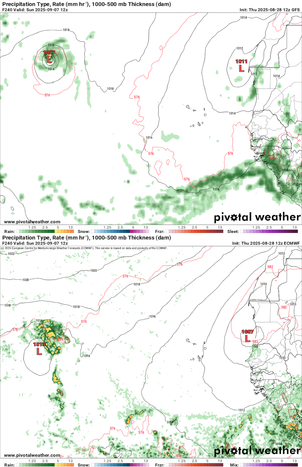
#15 Postby Kingarabian » Thu Aug 28, 2025 1:05 pm

12z GFS and Euro comparison:

Image
0 likes   
RIP Kobe Bryant

BobHarlem
Category 5
Category 5
Posts: 2362
Joined: Thu Oct 20, 2005 6:11 pm

Re: Area of interest in the Eastern Atlantic (0/20)

#16 Postby BobHarlem » Thu Aug 28, 2025 2:05 pm

12z euro rips it to shreds around 50w.
0 likes   

User avatar
DorkyMcDorkface
Category 4
Category 4
Posts: 916
Age: 27
Joined: Mon Sep 30, 2019 1:32 pm
Location: Mid-Atlantic

Re: Area of interest in the Eastern Atlantic (0/20)

#17 Postby DorkyMcDorkface » Thu Aug 28, 2025 2:09 pm

BobHarlem wrote:12z euro rips it to shreds around 50w.

Waiting for the full res run to appear on TT so I can post the shear graphic but I'm pretty sure it gets shredded by the TUTT. The feature is a lot weaker on the GFS which is why the storm is able to persist and resist it with ease.
0 likes   

Please note the thougths expressed by this account are solely those of the user and are from a hobbyist perspective. For more comprehensive analysis, consult an actual professional meteorologist or meteorology agency.


Floyd 1999 | Isabel 2003 | Hanna 2008 | Irene 2011 | Sandy 2012 | Isaias 2020

LarryWx
S2K Supporter
S2K Supporter
Posts: 6508
Joined: Sun Sep 07, 2003 2:04 pm
Location: GA

Re: Area of interest in the Eastern Atlantic (0/20)

#18 Postby LarryWx » Thu Aug 28, 2025 4:09 pm

For the record: after 4 12Z JMA runs in a row with a TC from this, today’s 12Z JMA had no TC.
0 likes   
Personal Forecast Disclaimer:
The posts in this forum are NOT official forecasts and should not be used as such. They are just the opinion of the poster and may or may not be backed by sound meteorological data. They are NOT endorsed by any professional institution or storm2k.org. For official information, please refer to the NHC and NWS products.

User avatar
cycloneye
Admin
Admin
Posts: 146346
Age: 69
Joined: Thu Oct 10, 2002 10:54 am
Location: San Juan, Puerto Rico

Re: Area of interest in the Eastern Atlantic (0/20)

#19 Postby cycloneye » Thu Aug 28, 2025 6:41 pm

Tropical Weather Outlook
NWS National Hurricane Center Miami FL
800 PM EDT Thu Aug 28 2025

For the North Atlantic...Caribbean Sea and the Gulf of America:

1. Eastern Tropical Atlantic:
A tropical wave is forecast to emerge off the west coast of Africa
on Sunday. Thereafter, environmental conditions could support some
slow development of this system while it moves westward to
west-northwestward at 15 to 20 mph across the eastern and central
tropical Atlantic next week.
* Formation chance through 48 hours...low...near 0 percent.
* Formation chance through 7 days...low...20 percent.


Forecaster Pasch
0 likes   
Visit the Caribbean-Central America Weather Thread where you can find at first post web cams,radars
and observations from Caribbean basin members Click Here

LarryWx
S2K Supporter
S2K Supporter
Posts: 6508
Joined: Sun Sep 07, 2003 2:04 pm
Location: GA

Re: Area of interest in the Eastern Atlantic (0/20)

#20 Postby LarryWx » Thu Aug 28, 2025 11:14 pm

0Z UKMET

NEW TROPICAL CYCLONE FORECAST TO DEVELOP AFTER 108 HOURS
FORECAST POSITION AT T+108 : 13.5N 28.4W

LEAD CENTRAL MAXIMUM WIND
VERIFYING TIME TIME POSITION PRESSURE (MB) SPEED (KNOTS)
-------------- ---- -------- ------------- -------------
1200UTC 02.09.2025 108 13.5N 28.4W 1010 31
0000UTC 03.09.2025 120 14.0N 30.9W 1011 33
1200UTC 03.09.2025 132 15.9N 31.8W 1010 34
0000UTC 04.09.2025 144 16.4N 34.6W 1012 28
1200UTC 04.09.2025 156 17.2N 35.4W 1013 26
0000UTC 05.09.2025 168 18.4N 36.8W 1013 24
0 likes   
Personal Forecast Disclaimer:
The posts in this forum are NOT official forecasts and should not be used as such. They are just the opinion of the poster and may or may not be backed by sound meteorological data. They are NOT endorsed by any professional institution or storm2k.org. For official information, please refer to the NHC and NWS products.


Return to “Talkin' Tropics”

Who is online

Users browsing this forum: No registered users and 54 guests