The ironic thing with this system is that it's forecast to reach the CPAC, and Kiko actually sounds more like a name from the CPAC list rather than the EPAC (IMO).
EPAC: KIKO - Remnants - Dscussion
Moderator: S2k Moderators
- AJC3
- Admin

- Posts: 4156
- Age: 62
- Joined: Tue Aug 31, 2004 7:04 pm
- Location: Ballston Spa, New York
- Contact:
Re: EPAC: INVEST 93E - Discussion (50/80)
The ironic thing with this system is that it's forecast to reach the CPAC, and Kiko actually sounds more like a name from the CPAC list rather than the EPAC (IMO).
2 likes
- cycloneye
- Admin

- Posts: 149721
- Age: 69
- Joined: Thu Oct 10, 2002 10:54 am
- Location: San Juan, Puerto Rico
Re: EPAC: INVEST 93E - Discussion (70/90)
Models are bullish for a CPAC hurricane.


2 likes
Visit the Caribbean-Central America Weather Thread where you can find at first post web cams,radars
and observations from Caribbean basin members Click Here
and observations from Caribbean basin members Click Here
- cycloneye
- Admin

- Posts: 149721
- Age: 69
- Joined: Thu Oct 10, 2002 10:54 am
- Location: San Juan, Puerto Rico
Re: EPAC: INVEST 93E - Discussion (80/90)
Tropical Weather Outlook
NWS National Hurricane Center Miami FL
500 PM PDT Sat Aug 30 2025
For the eastern and central North Pacific east of 180 longitude:
1. Western East Pacific (EP93):
Recent satellite wind data indicate that the disturbance located
about 925 miles southwest of the southern tip of the Baja California
peninsula continues to lack a well-defined low-level circulation.
However, shower and thunderstorm activity continues to show signs of
organization. Environmental conditions appear conducive for
additional development of this system, and a tropical depression is
expected to form during the next day or so while moving westward at
around 10 mph across the western part of the eastern Pacific basin.
The system is likely to cross into the central Pacific basin by the
middle to latter part of next week.
* Formation chance through 48 hours...high...80 percent.
* Formation chance through 7 days...high...90 percent.
0 likes
Visit the Caribbean-Central America Weather Thread where you can find at first post web cams,radars
and observations from Caribbean basin members Click Here
and observations from Caribbean basin members Click Here
- Kingarabian
- S2K Supporter

- Posts: 16379
- Joined: Sat Aug 08, 2009 3:06 am
- Location: Honolulu, Hawaii
Re: EPAC: INVEST 93E - Discussion (80/90)
Well defined and robust circulation. Could've been classified over 24 hours ago. Deeper convection starting to persist.
0 likes
RIP Kobe Bryant
- cycloneye
- Admin

- Posts: 149721
- Age: 69
- Joined: Thu Oct 10, 2002 10:54 am
- Location: San Juan, Puerto Rico
Re: EPAC: INVEST 93E - Discussion (80/90)
EP, 93, 2025083100, , BEST, 0, 144N, 1211W, 25, 1009, DB


0 likes
Visit the Caribbean-Central America Weather Thread where you can find at first post web cams,radars
and observations from Caribbean basin members Click Here
and observations from Caribbean basin members Click Here
- AJC3
- Admin

- Posts: 4156
- Age: 62
- Joined: Tue Aug 31, 2004 7:04 pm
- Location: Ballston Spa, New York
- Contact:
Re: EPAC: INVEST 93E - Discussion (90/90)
Tropical Weather Outlook
NWS National Hurricane Center Miami FL
1100 PM PDT Sat Aug 30 2025
For the eastern and central North Pacific east of 180 longitude:
Western East Pacific (EP93):
Showers and thunderstorms continue to become better organized in
association with an area of low pressure located about 1000 miles
southwest of the southern tip of the Baja California peninsula. If
these trends continue, a tropical depression is likely to develop
later tonight or on Sunday while it moves generally westward around
10 mph across the western part of the eastern Pacific basin. The
system is likely to cross into the central Pacific basin by the
middle to latter part of next week.
* Formation chance through 48 hours...high...90 percent.
* Formation chance through 7 days...high...90 percent.
0 likes
- Hurricane2022
- Category 5

- Posts: 2092
- Joined: Tue Aug 23, 2022 11:38 pm
- Location: Araçatuba, Brazil
Re: EPAC: INVEST 93E - Discussion (90/90)
HWRF, HAFS-A and B are all showing a possible major doing a WSW dip and tracking over 28-27 waters during this run. Note that they show some strong shear briefly weakening 93E in about 80 - 90 hours from now, and restrengthening later on. I hope Kiko can bring some ACE and annular candy to our eyes. 
1 likes
Sorry for the bad English sometimes...!
For reliable and detailed information for any meteorological phenomenon, please consult the National Hurricane Center, Joint Typhoon Warning Center , or your local Meteo Center.
--------
ECCE OMNIA NOVA FACIAM (Ap 21,5).
For reliable and detailed information for any meteorological phenomenon, please consult the National Hurricane Center, Joint Typhoon Warning Center , or your local Meteo Center.
--------
ECCE OMNIA NOVA FACIAM (Ap 21,5).
- cycloneye
- Admin

- Posts: 149721
- Age: 69
- Joined: Thu Oct 10, 2002 10:54 am
- Location: San Juan, Puerto Rico
Re: EPAC: ELEVEN -E - Tropical Depression - Discussion
BULLETIN
Tropical Depression Eleven-E Advisory Number 1
NWS National Hurricane Center Miami FL EP112025
1100 PM HST Sat Aug 30 2025
...TROPICAL DEPRESSION ELEVEN-E FORMS WELL SOUTHWEST OF THE
SOUTHERN TIP OF BAJA CALIFORNIA...
SUMMARY OF 1100 PM HST...0900 UTC...INFORMATION
-----------------------------------------------
LOCATION...14.4N 122.3W
ABOUT 1000 MI...1610 KM SW OF THE SOUTHERN TIP OF BAJA CALIFORNIA
MAXIMUM SUSTAINED WINDS...35 MPH...55 KM/H
PRESENT MOVEMENT...W OR 270 DEGREES AT 9 MPH...15 KM/H
MINIMUM CENTRAL PRESSURE...1009 MB...29.80 INCHES
Tropical Depression Eleven-E Discussion Number 1
NWS National Hurricane Center Miami FL EP112025
1100 PM HST Sat Aug 30 2025
Showers and thunderstorms associated with an area of low pressure
located well southwest of the southern tip of the Baja California
peninsula have become better organized over the past 12 hours. A
0507 UTC ASCAT-C pass showed a well-defined low-level circulation
with peak winds near 25 kt. However, given the continued improvement
in the satellite presentation and higher subjective Dvorak current
intensity estimates of 2.5/35 kt from both TAFB and SAB, advisories
are being initiated on Tropical Depression Eleven-E with an initial
intensity of 30 kt.
The depression is moving westward near 8 kt, or 270/8 kt, steered by
a strong subtropical ridge situated to its north. This ridge is
forecast to remain in place throughout the 5-day period, maintaining
a general westward motion across the western part of the eastern
Pacific basin and into the central Pacific basin late this week. The
official forecast track is close to the consensus aids.
Environmental conditions of warm sea surface temperatures, moist
mid-level air, and low vertical wind shear support steady
strengthening during the next few days. The depression is expected
to become a tropical storm later today, and could reach hurricane
strength by around 60 hours (Tuesday). Thereafter, the system’s
track near the 26 C isotherm, along with the possibility of some
mid-level dry air entrainment, could limit further intensification
later in the week. The intensity forecast is near the middle to
higher end of the guidance envelope through midweek, then trends
closer to the consensus thereafter.
FORECAST POSITIONS AND MAX WINDS
INIT 31/0900Z 14.4N 122.3W 30 KT 35 MPH
12H 31/1800Z 14.6N 123.6W 35 KT 40 MPH
24H 01/0600Z 14.6N 125.3W 40 KT 45 MPH
36H 01/1800Z 14.5N 126.8W 45 KT 50 MPH
48H 02/0600Z 14.4N 128.6W 55 KT 65 MPH
60H 02/1800Z 14.3N 130.4W 65 KT 75 MPH
72H 03/0600Z 14.2N 132.2W 75 KT 85 MPH
96H 04/0600Z 14.3N 135.9W 75 KT 85 MPH
120H 05/0600Z 14.3N 140.1W 75 KT 85 MPH
$$
Forecaster Gibbs (CPHC)
0 likes
Visit the Caribbean-Central America Weather Thread where you can find at first post web cams,radars
and observations from Caribbean basin members Click Here
and observations from Caribbean basin members Click Here
- Kingarabian
- S2K Supporter

- Posts: 16379
- Joined: Sat Aug 08, 2009 3:06 am
- Location: Honolulu, Hawaii
Re: EPAC: ELEVEN -E - Tropical Depression - Discussion
GFS has back to back runs showing this getting really close to the Big Island of Hawaii.
0 likes
RIP Kobe Bryant
- Kingarabian
- S2K Supporter

- Posts: 16379
- Joined: Sat Aug 08, 2009 3:06 am
- Location: Honolulu, Hawaii
Re: EPAC: ELEVEN -E - Tropical Depression - Discussion
Euro also getting it pretty close as well. Some ensembles do show landfall from both models.
Looks like it will round the sub tropical ridge. Question is will the ridge build back once it begins the pronounced WNW turn. Hawaiian Islands are an extremely small target. This can easily go just north or just south of Hawaii.
Looks like it will round the sub tropical ridge. Question is will the ridge build back once it begins the pronounced WNW turn. Hawaiian Islands are an extremely small target. This can easily go just north or just south of Hawaii.
0 likes
RIP Kobe Bryant
- cycloneye
- Admin

- Posts: 149721
- Age: 69
- Joined: Thu Oct 10, 2002 10:54 am
- Location: San Juan, Puerto Rico
Re: EPAC: ELEVEN -E - Tropical Depression - Discussion
A. 11E (NONAME)
B. 31/1200Z
C. 14.4N
D. 123.0W
E. THREE/GOES-W
F. T3.0/3.0
G. IR/EIR/PRXY
H. REMARKS...6/10 BANDING RESULTS IN A DT OF 3.0. THE MET IS 3.0 BASED
ON A RAPIDLY DEVELOPING 24 HOUR TREND. THE PT IS 3.0. THE FT IS BASED
ON THE DT.
I. ADDL POSITIONS
NIL
...MONAGHAN
B. 31/1200Z
C. 14.4N
D. 123.0W
E. THREE/GOES-W
F. T3.0/3.0
G. IR/EIR/PRXY
H. REMARKS...6/10 BANDING RESULTS IN A DT OF 3.0. THE MET IS 3.0 BASED
ON A RAPIDLY DEVELOPING 24 HOUR TREND. THE PT IS 3.0. THE FT IS BASED
ON THE DT.
I. ADDL POSITIONS
NIL
...MONAGHAN
0 likes
Visit the Caribbean-Central America Weather Thread where you can find at first post web cams,radars
and observations from Caribbean basin members Click Here
and observations from Caribbean basin members Click Here
- Kingarabian
- S2K Supporter

- Posts: 16379
- Joined: Sat Aug 08, 2009 3:06 am
- Location: Honolulu, Hawaii
Re: EPAC: ELEVEN -E - Tropical Depression - Discussion
cycloneye wrote:A. 11E (NONAME)
B. 31/1200Z
C. 14.4N
D. 123.0W
E. THREE/GOES-W
F. T3.0/3.0
G. IR/EIR/PRXY
H. REMARKS...6/10 BANDING RESULTS IN A DT OF 3.0. THE MET IS 3.0 BASED
ON A RAPIDLY DEVELOPING 24 HOUR TREND. THE PT IS 3.0. THE FT IS BASED
ON THE DT.
I. ADDL POSITIONS
NIL
...MONAGHAN
Agreed here. But the reason SAB is at 3.0 already is because they delayed classifying this for the past 36 hours.
0 likes
RIP Kobe Bryant
- cycloneye
- Admin

- Posts: 149721
- Age: 69
- Joined: Thu Oct 10, 2002 10:54 am
- Location: San Juan, Puerto Rico
Re: EPAC: ELEVEN -E - Tropical Depression - Discussion

1 likes
Visit the Caribbean-Central America Weather Thread where you can find at first post web cams,radars
and observations from Caribbean basin members Click Here
and observations from Caribbean basin members Click Here
- cycloneye
- Admin

- Posts: 149721
- Age: 69
- Joined: Thu Oct 10, 2002 10:54 am
- Location: San Juan, Puerto Rico
Re: EPAC: KIKO - Tropical Storm - Discussion
BULLETIN
Tropical Storm Kiko Advisory Number 2
NWS National Hurricane Center Miami FL EP112025
500 AM HST Sun Aug 31 2025
...DEPRESSION STRENGTHENS TO TROPICAL STORM KIKO...
SUMMARY OF 500 AM HST...1500 UTC...INFORMATION
----------------------------------------------
LOCATION...14.4N 123.1W
ABOUT 1045 MI...1680 KM WSW OF THE SOUTHERN TIP OF BAJA CALIFORNIA
MAXIMUM SUSTAINED WINDS...40 MPH...65 KM/H
PRESENT MOVEMENT...W OR 270 DEGREES AT 9 MPH...15 KM/H
MINIMUM CENTRAL PRESSURE...1007 MB...29.74 INCHES
Tropical Storm Kiko Discussion Number 2
NWS National Hurricane Center Miami FL EP112025
500 AM HST Sun Aug 31 2025
Satellite imagery and a recent AMSR2 pass show a curved band
wrapping around the western semicircle of the cyclone, along with a
burst of deep convection developing over the center where cloud tops
are near -80 C. The convective banding now wraps more than halfway
around the circulation, which, along with Dvorak current intensity
estimates of 2.5/35 kt from TAFB and up to 3.0/45 kt from SAB,
supports upgrading the system to Tropical Storm Kiko with an initial
intensity of 35 kt.
Kiko is moving westward near 8 kt, or 270/8 kt, steered by a strong
subtropical ridge positioned to its north. This ridge is expected to
remain in place throughout the 5-day forecast period, maintaining a
general westward motion across the eastern Pacific and into the
central Pacific basin by late this week. The official track forecast
is nearly identical to the previous forecast and remains close to
the consensus aids.
Environmental conditions of warm sea surface temperatures, moist
mid-level air, and low vertical wind shear favor steady
strengthening during the next couple of days. Kiko is forecast to
reach hurricane intensity by around 48 hours (Tuesday). Thereafter,
the cyclone’s track near the 26 C isotherm, along with the potential
entrainment of mid-level dry air, could limit any additional
significant intensification. Also, any deviation of the track
slightly to the right of the forecast path could place the system
over cooler waters and further inhibit strengthening. The intensity
forecast is near the middle to higher end of the guidance envelope
through midweek, then trends closer to the consensus thereafter.
FORECAST POSITIONS AND MAX WINDS
INIT 31/1500Z 14.4N 123.1W 35 KT 40 MPH
12H 01/0000Z 14.5N 124.4W 40 KT 45 MPH
24H 01/1200Z 14.4N 126.1W 45 KT 50 MPH
36H 02/0000Z 14.3N 127.7W 55 KT 65 MPH
48H 02/1200Z 14.2N 129.4W 65 KT 75 MPH
60H 03/0000Z 14.2N 131.2W 70 KT 80 MPH
72H 03/1200Z 14.1N 133.1W 75 KT 85 MPH
96H 04/1200Z 14.2N 137.0W 75 KT 85 MPH
120H 05/1200Z 14.2N 140.9W 75 KT 85 MPH
$$
Forecaster Gibbs (CPHC)
0 likes
Visit the Caribbean-Central America Weather Thread where you can find at first post web cams,radars
and observations from Caribbean basin members Click Here
and observations from Caribbean basin members Click Here
- Kingarabian
- S2K Supporter

- Posts: 16379
- Joined: Sat Aug 08, 2009 3:06 am
- Location: Honolulu, Hawaii
Re: EPAC: KIKO - Tropical Storm - Discussion
12z GFS is north of Hawaii. Keeps it a coherent system. Models are trending toward favorable upper level westerlies.
Last edited by Kingarabian on Sun Aug 31, 2025 1:20 pm, edited 1 time in total.
0 likes
RIP Kobe Bryant
- Kingarabian
- S2K Supporter

- Posts: 16379
- Joined: Sat Aug 08, 2009 3:06 am
- Location: Honolulu, Hawaii
Re: EPAC: KIKO - Tropical Storm - Discussion
12z GEFS pointing towards Hawaii.
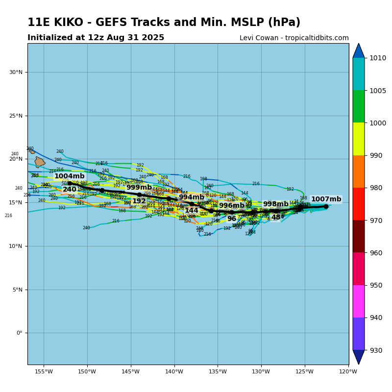
Keep in mind this track synopsis is based on Kiko rounding the ridge. If the Ridge builds back late, Kiko goes north of Hawaii. If it builds back west quick, Kiko goes south of Hawaii. It will take impeccable timing for a landfall. That's why it's rare to get a landfall from the east although there have been some systems landfalling or getting extremely close in the past 11 years.

Keep in mind this track synopsis is based on Kiko rounding the ridge. If the Ridge builds back late, Kiko goes north of Hawaii. If it builds back west quick, Kiko goes south of Hawaii. It will take impeccable timing for a landfall. That's why it's rare to get a landfall from the east although there have been some systems landfalling or getting extremely close in the past 11 years.
2 likes
RIP Kobe Bryant
- Kingarabian
- S2K Supporter

- Posts: 16379
- Joined: Sat Aug 08, 2009 3:06 am
- Location: Honolulu, Hawaii
Re: EPAC: KIKO - Tropical Storm - Discussion
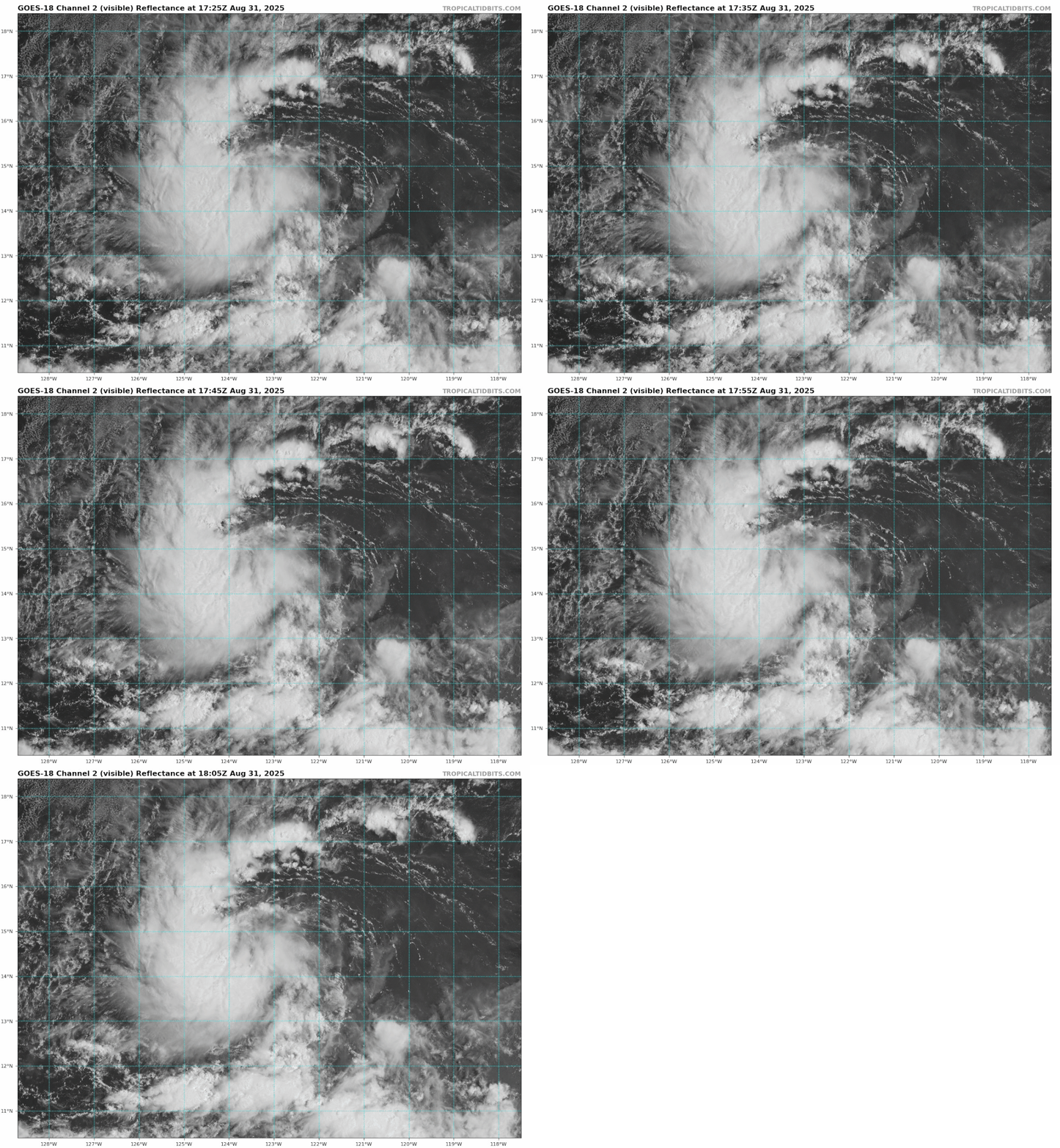
Easterly winds blowing convection away from the center.
0 likes
RIP Kobe Bryant
-
TomballEd
- Category 5

- Posts: 1322
- Age: 62
- Joined: Wed Aug 16, 2023 4:52 pm
- Location: Spring/Klein area, not Tomball
Re: EPAC: KIKO - Tropical Storm - Discussion
Kingarabian wrote:12z GEFS pointing towards Hawaii.
https://i.postimg.cc/L5xLYdPc/11-E-gefs-latest.png
Keep in mind this track synopsis is based on Kiko rounding the ridge. If the Ridge builds back late, Kiko goes north of Hawaii. If it builds back west quick, Kiko goes south of Hawaii. It will take impeccable timing for a landfall. That's why it's rare to get a landfall from the east although there have been some systems landfalling or getting extremely close in the past 11 years.
I expect something in the East or Central Gulf end of September or October (or maybe two somethings) but it would be interesting if Kiko was the most significant storm to affect the 50 states. If not for Andrew, Iniki would have been the most impactful storm the year it hit.
2 likes
Re: EPAC: KIKO - Tropical Storm - Discussion
Plenty of time for Kiko to become a formidable cane. Agree with Kingarabian shooting gallery could go north or south or direct just depends on that ridge.
2 likes
The above post and any post by Ntxw is NOT an official forecast and should not be used as such. It is just the opinion of the poster and may or may not be backed by sound meteorological data. It is NOT endorsed by any professional institution including Storm2k. For official information, please refer to NWS products.
- Kingarabian
- S2K Supporter

- Posts: 16379
- Joined: Sat Aug 08, 2009 3:06 am
- Location: Honolulu, Hawaii
Re: EPAC: KIKO - Tropical Storm - Discussion
12z Euro with very noticeable SW dip. Could see a significant system out of this.
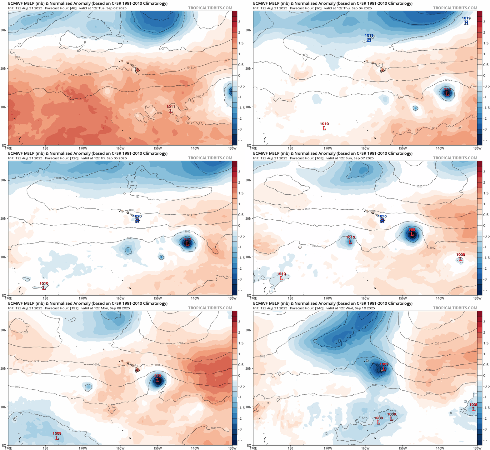
Pay no attention to the Euro/CMC/ICON initial intensities for Kiko as it nears 140W. Models struggle with intensity in this area.

Pay no attention to the Euro/CMC/ICON initial intensities for Kiko as it nears 140W. Models struggle with intensity in this area.
1 likes
RIP Kobe Bryant
Who is online
Users browsing this forum: No registered users and 44 guests


