EPAC: LORENA - Hurricane - Discussion

Current storms and invests:

Moderators: hurricanetrack, S2k Moderators


The posts in this forum are NOT official forecasts and should not be used as such. They are just the opinion of the poster and may or may not be backed by sound meteorological data. They are NOT endorsed by any professional institution or STORM2K. For official information, please refer to products from the National Hurricane Center and National Weather Service.

Help Support Storm2K
Message
Author
User avatar
Kingarabian
S2K Supporter
S2K Supporter
Posts: 16147
Joined: Sat Aug 08, 2009 3:06 am
Location: Honolulu, Hawaii

EPAC: LORENA - Hurricane - Discussion

#1 Postby Kingarabian » Mon Sep 01, 2025 8:43 am

EP, 94, 2025090112, , BEST, 0, 153N, 1026W, 25, 1009, DB


https://ftp.nhc.noaa.gov/atcf/btk/bep122025.dat

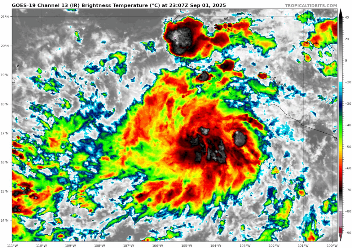
Models pointing towards a Baja landfall. Dry air and cooler waters are dominant west of Baja California. Also this system is quite broad. Only way for a strong landfall is if it strengthens quickly and moves quickly before landfall.
0 likes   
RIP Kobe Bryant

User avatar
cycloneye
Admin
Admin
Posts: 146446
Age: 69
Joined: Thu Oct 10, 2002 10:54 am
Location: San Juan, Puerto Rico

Re: EPAC: INVEST 94E - Discussion (80/90)

#2 Postby cycloneye » Mon Sep 01, 2025 12:41 pm

South of Southwestern Mexico (EP94):
Showers and thunderstorms associated with a tropical wave located
less than 150 miles off the coast of southwestern Mexico are
starting to become better organized, and recent satellite-derived
wind data indicate that winds to 35 mph are present in the
disturbance close to the coast of Mexico. This system is expected
to become a tropical depression by the middle of the week. This
system is expected to move west-northwestward to northwestward at
10 to 15 mph off the coast of southwestern Mexico during the next
couple of days, then could turn northward and approach the Baja
California peninsula later this week. Interests in the Baja
California peninsula should monitor the progress of the
disturbance, as watches or warnings could be required for portions
of this area on Tuesday. Regardless of development, heavy rainfall
is possible across coastal portions of southwestern and
west-central Mexico today through mid-week. Heavy rainfall is also
expected across Baja California Sur and northwestern Mexico Tuesday
night through late this week. This heavy rainfall could lead to
flash flooding, especially in mountainous areas.
* Formation chance through 48 hours...high...80 percent.
* Formation chance through 7 days...high...90 percent.
0 likes   
Visit the Caribbean-Central America Weather Thread where you can find at first post web cams,radars
and observations from Caribbean basin members Click Here

User avatar
Yellow Evan
Professional-Met
Professional-Met
Posts: 16174
Age: 27
Joined: Fri Jul 15, 2011 12:48 pm
Location: Henderson, Nevada/Honolulu, HI
Contact:

Re: EPAC: INVEST 94E - Discussion (80/90)

#3 Postby Yellow Evan » Mon Sep 01, 2025 4:10 pm

ASCAT has no westerlies but IR is strongly indicative of a forming TC.
0 likes   

User avatar
cycloneye
Admin
Admin
Posts: 146446
Age: 69
Joined: Thu Oct 10, 2002 10:54 am
Location: San Juan, Puerto Rico

Re: EPAC: INVEST 94E - Discussion (80/90)

#4 Postby cycloneye » Mon Sep 01, 2025 4:41 pm

This looks like a TC.

Image
4 likes   
Visit the Caribbean-Central America Weather Thread where you can find at first post web cams,radars
and observations from Caribbean basin members Click Here

User avatar
Hurricane2022
Category 5
Category 5
Posts: 1654
Joined: Tue Aug 23, 2022 11:38 pm
Location: Araçatuba, Brazil

Re: EPAC: INVEST 94E - Discussion (80/90)

#5 Postby Hurricane2022 » Mon Sep 01, 2025 4:50 pm

1 likes   
Sorry for the bad English sometimes...!
For reliable and detailed information for any meteorological phenomenon, please consult the National Hurricane Center, Joint Typhoon Warning Center , or your local Meteo Center.

--------

Una cvm Christo, pro Christo, et in Christo. Sit nomen Domini benedictvm.

User avatar
Kingarabian
S2K Supporter
S2K Supporter
Posts: 16147
Joined: Sat Aug 08, 2009 3:06 am
Location: Honolulu, Hawaii

Re: EPAC: INVEST 94E - Discussion (80/90)

#6 Postby Kingarabian » Mon Sep 01, 2025 6:08 pm

This is ahead of schedule. It's likely already a TS.
0 likes   
RIP Kobe Bryant

User avatar
cycloneye
Admin
Admin
Posts: 146446
Age: 69
Joined: Thu Oct 10, 2002 10:54 am
Location: San Juan, Puerto Rico

Re: EPAC: INVEST 94E - Discussion (90/90)

#7 Postby cycloneye » Mon Sep 01, 2025 6:19 pm

South of Southwestern Mexico (EP94):
Showers and thunderstorms are becoming better organized in
association with a broad area of low pressure located a little more
than 100 miles off the coast of southwestern Mexico. In addition,
earlier satellite-derived wind data indicate that winds to 35 mph
are occurring on its north side, close to the coast of Mexico. This
system is expected to become a tropical depression or tropical storm
in the next day or so while it moves west-northwestward at 10 to 15
mph off the coast of southwestern Mexico. The disturbance is
expected to turn northwestward toward the Baja California peninsula
later in the week, and watches or warnings could be required for
portions of that area on Tuesday. Regardless of development, heavy
rainfall is possible across coastal portions of southwestern and
west-central Mexico during the next few days, and these rains will
likely spread to Baja California Sur later in the week. The heavy
rains could lead to flash flooding, especially in mountainous areas.
* Formation chance through 48 hours...high...90 percent.
* Formation chance through 7 days...high...90 percent.
0 likes   
Visit the Caribbean-Central America Weather Thread where you can find at first post web cams,radars
and observations from Caribbean basin members Click Here

User avatar
AnnularCane
S2K Supporter
S2K Supporter
Posts: 2895
Joined: Thu Jun 08, 2006 9:18 am
Location: Wytheville, VA

Re: EPAC: INVEST 94E - Discussion (80/90)

#8 Postby AnnularCane » Mon Sep 01, 2025 6:22 pm

cycloneye wrote:This looks like a TC.

https://i.imgur.com/tjEIhdS.gif


Looks kind of like Kiko without the eye.
0 likes   
"But it never rained rain. It never snowed snow. And it never blew just wind. It rained things like soup and juice. It snowed mashed potatoes and green peas. And sometimes the wind blew in storms of hamburgers." -- Judi Barrett, Cloudy with a Chance of Meatballs

User avatar
Kingarabian
S2K Supporter
S2K Supporter
Posts: 16147
Joined: Sat Aug 08, 2009 3:06 am
Location: Honolulu, Hawaii

Re: EPAC: INVEST 94E - Discussion (90/90)

#9 Postby Kingarabian » Mon Sep 01, 2025 6:40 pm

cycloneye wrote:
South of Southwestern Mexico (EP94):
Showers and thunderstorms are becoming better organized in
association with a broad area of low pressure located a little more
than 100 miles off the coast of southwestern Mexico. In addition,
earlier satellite-derived wind data indicate that winds to 35 mph
are occurring on its north side, close to the coast of Mexico. This
system is expected to become a tropical depression or tropical storm
in the next day or so while it moves west-northwestward at 10 to 15
mph off the coast of southwestern Mexico. The disturbance is
expected to turn northwestward toward the Baja California peninsula
later in the week, and watches or warnings could be required for
portions of that area on Tuesday. Regardless of development, heavy
rainfall is possible across coastal portions of southwestern and
west-central Mexico during the next few days, and these rains will
likely spread to Baja California Sur later in the week. The heavy
rains could lead to flash flooding, especially in mountainous areas.
* Formation chance through 48 hours...high...90 percent.
* Formation chance through 7 days...high...90 percent.


I don't get it. System is close to land as well.
0 likes   
RIP Kobe Bryant

User avatar
Hurricane2022
Category 5
Category 5
Posts: 1654
Joined: Tue Aug 23, 2022 11:38 pm
Location: Araçatuba, Brazil

Re: EPAC: INVEST 94E - Discussion (90/90)

#10 Postby Hurricane2022 » Mon Sep 01, 2025 6:58 pm

I'm thinking this may surprise us and become a strong cane in the next days. Time over warm ssts is limited but who knows. It has a good atmospheric environment ahead and SHIPS is quite bullish with this
1 likes   
Sorry for the bad English sometimes...!
For reliable and detailed information for any meteorological phenomenon, please consult the National Hurricane Center, Joint Typhoon Warning Center , or your local Meteo Center.

--------

Una cvm Christo, pro Christo, et in Christo. Sit nomen Domini benedictvm.

User avatar
Kingarabian
S2K Supporter
S2K Supporter
Posts: 16147
Joined: Sat Aug 08, 2009 3:06 am
Location: Honolulu, Hawaii

Re: EPAC: INVEST 94E - Discussion (90/90)

#11 Postby Kingarabian » Mon Sep 01, 2025 7:16 pm

GFS is quite bullish in the medium range.
0 likes   
RIP Kobe Bryant

User avatar
cycloneye
Admin
Admin
Posts: 146446
Age: 69
Joined: Thu Oct 10, 2002 10:54 am
Location: San Juan, Puerto Rico

Re: EPAC: INVEST 94E - Discussion (90/90)

#12 Postby cycloneye » Mon Sep 01, 2025 7:48 pm

EP, 94, 2025090200, , BEST, 0, 170N, 1048W, 30, 1007, DB
0 likes   
Visit the Caribbean-Central America Weather Thread where you can find at first post web cams,radars
and observations from Caribbean basin members Click Here

Subtrop
Category 2
Category 2
Posts: 682
Joined: Sun Feb 21, 2021 9:45 pm

Re: EPAC: INVEST 94E - Discussion (90/90)

#13 Postby Subtrop » Mon Sep 01, 2025 8:48 pm

EP, 12, 2025090200, , BEST, 0, 170N, 1048W, 30, 1007, DB, 34, NEQ, 0, 0, 0, 0, 1009, 120, 60, 0, 0, E, 0, , 0, 0, TWELVE, S, 0, , 0, 0, 0, 0, genesis-num, 021, TRANSITIONED, epC42025 to ep122025,
2 likes   

Sciencerocks
Category 5
Category 5
Posts: 9361
Age: 39
Joined: Thu Jul 06, 2017 1:51 am

Re: EPAC: INVEST 94E - Discussion (90/90)

#14 Postby Sciencerocks » Mon Sep 01, 2025 9:04 pm

Image
0 likes   

User avatar
cycloneye
Admin
Admin
Posts: 146446
Age: 69
Joined: Thu Oct 10, 2002 10:54 am
Location: San Juan, Puerto Rico

Re: EPAC: TWELVE-E - Tropical Depression - Discussion

#15 Postby cycloneye » Mon Sep 01, 2025 9:46 pm

BULLETIN
Tropical Depression Twelve-E Advisory Number 1
NWS National Hurricane Center Miami FL EP122025
900 PM CST Mon Sep 01 2025

...TROPICAL DEPRESSION FORMS TO THE SOUTH OF SOUTHWESTERN MEXICO...


SUMMARY OF 900 PM CST...0300 UTC...INFORMATION
----------------------------------------------
LOCATION...17.2N 105.4W
ABOUT 145 MI...230 KM SSW OF MANZANILLO MEXICO
MAXIMUM SUSTAINED WINDS...35 MPH...55 KM/H
PRESENT MOVEMENT...WNW OR 295 DEGREES AT 14 MPH...22 KM/H
MINIMUM CENTRAL PRESSURE...1007 MB...29.74 INCHES


EP2

Tropical Depression Twelve-E Discussion Number 1
NWS National Hurricane Center Miami FL EP122025
900 PM CST Mon Sep 01 2025

Deep convection associated with a low pressure system to the south
of southwestern Mexico has persisted and continues to become better
organized over the past several hours. There is a fairly
well-defined upper-level anticyclonic outflow pattern over the area,
with cloud tops to -70 deg C or colder near the estimated center.
Based on the increased organization of the cloud pattern, the system
is being designated as a tropical depression at this time. Dvorak
satellite classifications are 1.5/1.5 and 2.0/2.0 from TAFB and SAB,
respectively, which supports a current intensity estimate of about
30 kt.

The initial motion is a somewhat uncertain 295/12 kt. A mid-level
ridge to the northeast of the tropical cyclone should cause the
system to move on a west-northwestward to northwestward track for
the next couple of days. Steering currents are expected to
gradually weaken through the forecast period, resulting in a
decrease in the forward speed of the cyclone. In 3 to 5 days, the
slow-moving system is expected to turn northward and then
northeastward into a weakness in the ridge. The official track
forecast is close to the latest corrected consensus guidance, HCCA.

The tropical cyclone is currently situated in a weak shear
environment over SSTs of around 30 deg C. Strengthening is likely,
and the system will probably be nearing hurricane intensity in a
couple of days. Later in the forecast period, cooler ocean waters
and a more stable air mass should cause gradual weakening. The
official forecast is similar to the IVCN intensity model consensus.

Interests in southwestern Mexico and Baja California Sur should
monitor the progress of this system. A Tropical Storm Watch could
be required for portions of Baja California on Tuesday.


FORECAST POSITIONS AND MAX WINDS

INIT 02/0300Z 17.2N 105.4W 30 KT 35 MPH
12H 02/1200Z 18.3N 107.0W 35 KT 40 MPH
24H 03/0000Z 19.7N 109.0W 45 KT 50 MPH
36H 03/1200Z 21.0N 111.0W 55 KT 65 MPH
48H 04/0000Z 22.0N 112.5W 60 KT 70 MPH
60H 04/1200Z 23.0N 113.3W 60 KT 70 MPH
72H 05/0000Z 24.0N 113.7W 55 KT 65 MPH
96H 06/0000Z 26.3N 113.0W 50 KT 60 MPH
120H 07/0000Z 28.2N 111.8W 35 KT 40 MPH

$$
Forecaster Pasch
0 likes   
Visit the Caribbean-Central America Weather Thread where you can find at first post web cams,radars
and observations from Caribbean basin members Click Here

User avatar
Teban54
Category 5
Category 5
Posts: 3271
Joined: Sat May 19, 2018 1:19 pm

Re: EPAC: TWELVE-E - Tropical Depression - Discussion

#16 Postby Teban54 » Mon Sep 01, 2025 11:13 pm

Looks pretty good for a TD.

Image
1 likes   

User avatar
cycloneye
Admin
Admin
Posts: 146446
Age: 69
Joined: Thu Oct 10, 2002 10:54 am
Location: San Juan, Puerto Rico

Re: EPAC: TWELVE-E - Tropical Depression - Discussion

#17 Postby cycloneye » Tue Sep 02, 2025 3:51 am

BULLETIN
Tropical Depression Twelve-E Advisory Number 2
NWS National Hurricane Center Miami FL EP122025
200 AM MST Tue Sep 02 2025

...TROPICAL DEPRESSION FORECAST TO STRENGTHEN LATER TODAY...


SUMMARY OF 200 AM MST...0900 UTC...INFORMATION
----------------------------------------------
LOCATION...17.6N 106.8W
ABOUT 190 MI...305 KM WSW OF MANZANILLO MEXICO
MAXIMUM SUSTAINED WINDS...35 MPH...55 KM/H
PRESENT MOVEMENT...WNW OR 290 DEGREES AT 15 MPH...24 KM/H
MINIMUM CENTRAL PRESSURE...1007 MB...29.74 INCHES
0 likes   
Visit the Caribbean-Central America Weather Thread where you can find at first post web cams,radars
and observations from Caribbean basin members Click Here

User avatar
cycloneye
Admin
Admin
Posts: 146446
Age: 69
Joined: Thu Oct 10, 2002 10:54 am
Location: San Juan, Puerto Rico

Re: EPAC: TWELVE-E - Tropical Depression - Discussion

#18 Postby cycloneye » Tue Sep 02, 2025 7:48 am

Let's say hello to TS Lorena.

EP, 12, 2025090212, , BEST, 0, 179N, 1074W, 35, 1005, TS
3 likes   
Visit the Caribbean-Central America Weather Thread where you can find at first post web cams,radars
and observations from Caribbean basin members Click Here

User avatar
cycloneye
Admin
Admin
Posts: 146446
Age: 69
Joined: Thu Oct 10, 2002 10:54 am
Location: San Juan, Puerto Rico

Re: EPAC: LORENA - Tropical Storm - Discussion

#19 Postby cycloneye » Tue Sep 02, 2025 9:58 am

BULLETIN
Tropical Storm Lorena Advisory Number 3
NWS National Hurricane Center Miami FL EP122025
Issued by the NWS Weather Prediction Center College Park MD
800 AM MST Tue Sep 02 2025

...TROPICAL DEPRESSION TWELVE-E BECOMES TROPICAL STORM LORENA...


SUMMARY OF 800 AM MST...1500 UTC...INFORMATION
----------------------------------------------
LOCATION...18.3N 107.9W
ABOUT 240 MI...385 KM W OF MANZANILLO MEXICO
ABOUT 345 MI...550 KM SSE OF CABO SAN LUCAS MEXICO
MAXIMUM SUSTAINED WINDS...45 MPH...75 KM/H
PRESENT MOVEMENT...NW OR 310 DEGREES AT 14 MPH...22 KM/H
MINIMUM CENTRAL PRESSURE...1004 MB...29.65 INCHES


Tropical Storm Lorena Discussion Number 3
NWS National Hurricane Center Miami FL EP122025
Issued by the NWS Weather Prediction Center College Park MD
800 AM MST Tue Sep 02 2025

GOES-East imagery depicts a steadily improving convective structure,
where earlier the presentation was more elongated, but more recently
is taking on a banded structure with bursting overshooting tops near
the center, suggesting better overall organization of the small
core. Recent Dvorak satellite estimates from TAFB/SAB are at 2.5
and 3.5, respectively, indicative of the intensification. As such,
initial intensity is set at 40 kt, slightly favoring the TAFB
estimate though satellite trends continue to improve. Thus, Tropical
Depression Twelve-E has been upgraded to Tropical Storm Lorena.

The cyclone is now moving northwestward at 12 kt along the
southwestern periphery of a mid-level ridge. The ridge should steer
the storm generally northwestward for the next couple of days.
However, the strength and therefore, depth of the cyclone will have
a sizable impact on its expected track and potential recurvature
towards Baja California. Model solutions that are stronger bring
the cyclone northward and eastward relative to the overall guidance
suite closer to Baja California earlier. Thus interests along Baja
California Sur should monitor updates to the track closely. Given
overall trends, a slightly faster, northward adjustment to the track
was made. The latest track forecast shows landfall in central Baja
at 96 hours, but there remains significant spread in the track
guidance, with the latest GFS forecast faster and to the east, while
the most recent ECMWF forecast is a significant leftward outlier,
not ever reaching the Mexican coastline. Given the spread, stay
tuned to updates in subsequent forecast packages.

Very warm waters and ample deep layer moisture will allow for a
steady intensification over the next few days, with increasing
potential for Lorena to reach hurricane status in the next next 24
to 48 hours. Lorena is expected to cross the 26 degree C isotherm in
2-3 days. That factor, in combination with increasing southwesterly
vertical shear should result in weakening after that time until
landfall across the Baja California Peninsula. The latest NHC
intensity forecast is higher than the previous cycle, but remains a
little under the HCCA consensus aid.

Interests in southwestern Mexico and Baja California Sur should
monitor the progress of this system. A Tropical Storm Watch could
be required for portions of Baja California later today or
Wednesday.

Key Messages:

1. Heavy rainfall associated with Tropical Storm Lorena will begin
to affect Baja California Sur on Wednesday, and southwestern Sonora
by Thursday. This will increase the risk of life-threatening flash
floods and mudslides, especially in areas of higher terrain.

2. Lorena is forecast to approach the Baja California peninsula
later this week. Although it is too soon to specify the exact
location and magnitude of wind impacts, residents should closely
monitor the latest forecast updates and ensure that they have their
preparedness plan in place. Watches could be required for a portion
of the Baja California peninsula later today or on Wednesday.


FORECAST POSITIONS AND MAX WINDS

INIT 02/1500Z 18.3N 107.9W 40 KT 45 MPH
12H 03/0000Z 19.4N 109.5W 50 KT 60 MPH
24H 03/1200Z 20.7N 111.3W 60 KT 70 MPH
36H 04/0000Z 21.9N 112.7W 70 KT 80 MPH
48H 04/1200Z 23.0N 113.8W 70 KT 80 MPH
60H 05/0000Z 23.9N 114.2W 55 KT 65 MPH
72H 05/1200Z 24.9N 114.1W 50 KT 60 MPH
96H 06/1200Z 26.8N 113.2W 40 KT 45 MPH...INLAND
120H 07/1200Z 28.9N 111.7W 30 KT 35 MPH...INLAND

$$
Forecaster Gallina


Image
1 likes   
Visit the Caribbean-Central America Weather Thread where you can find at first post web cams,radars
and observations from Caribbean basin members Click Here

User avatar
cycloneye
Admin
Admin
Posts: 146446
Age: 69
Joined: Thu Oct 10, 2002 10:54 am
Location: San Juan, Puerto Rico

Re: EPAC: LORENA - Tropical Storm - Discussion

#20 Postby cycloneye » Tue Sep 02, 2025 10:56 am

Image
0 likes   
Visit the Caribbean-Central America Weather Thread where you can find at first post web cams,radars
and observations from Caribbean basin members Click Here


Return to “Active Storms/Invests - Atlantic/EastPAC/CentralPAC/MED”

Who is online

Users browsing this forum: No registered users and 80 guests