EPAC: KIKO - Remnants - Dscussion
Moderator: S2k Moderators
-
Kingarabian

- S2K Supporter

- Posts: 16379
- Joined: Sat Aug 08, 2009 3:06 am
- Location: Honolulu, Hawaii


Re: EPAC: KIKO - Tropical Storm - Discussion
Think this will go at least a cat 4. Small, compact can ramp up quickly as has shown.
2 likes
The above post and any post by Ntxw is NOT an official forecast and should not be used as such. It is just the opinion of the poster and may or may not be backed by sound meteorological data. It is NOT endorsed by any professional institution including Storm2k. For official information, please refer to NWS products.
Help support Storm2K!

-
Kingarabian
- S2K Supporter
- Posts: 16379
- Joined: Sat Aug 08, 2009 3:06 am
- Location: Honolulu, Hawaii
Re: EPAC: KIKO - Tropical Storm - Discussion
GFS simulated IR has this doubling in size over the next 5 days.
1 likes
RIP Kobe Bryant
-
Kingarabian
- S2K Supporter
- Posts: 16379
- Joined: Sat Aug 08, 2009 3:06 am
- Location: Honolulu, Hawaii
Re: EPAC: KIKO - Tropical Storm - Discussion
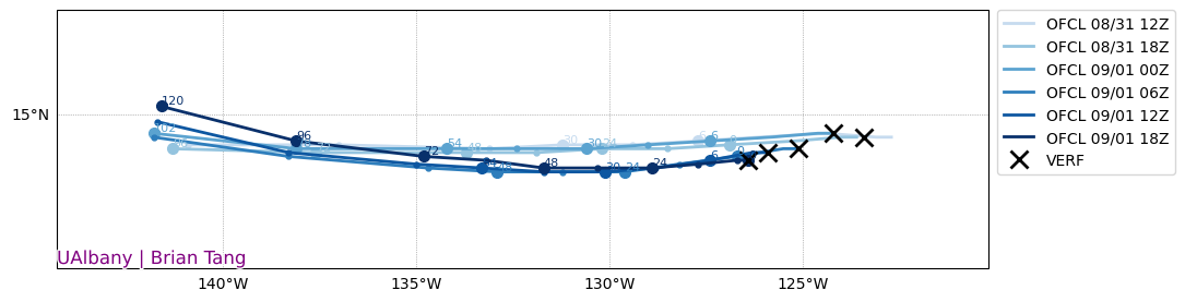
Significant spread remains in the 5 to 7 day range.
Euro/ICON/CMC are south of Hawaii and faster. GFS is to the NE of Hawaii and slower. UKMET is in the middle. Both solutions clear Hawaii. But the mean of those two solutions still equates to a landfall risk.
Euro/ICON/CMC are south of Hawaii and faster. GFS is to the NE of Hawaii and slower. UKMET is in the middle. Both solutions clear Hawaii. But the mean of those two solutions still equates to a landfall risk.
2 likes
RIP Kobe Bryant
-
Kingarabian
- S2K Supporter
- Posts: 16379
- Joined: Sat Aug 08, 2009 3:06 am
- Location: Honolulu, Hawaii
Re: EPAC: KIKO - Tropical Storm - Discussion
NHC had to adjust the track south a few times over the past 6 cycles.
1 likes
RIP Kobe Bryant
-
Sciencerocks
- Category 5

- Posts: 10193
- Age: 40
- Joined: Thu Jul 06, 2017 1:51 am

-
cycloneye

- Admin

- Posts: 149730
- Age: 69
- Joined: Thu Oct 10, 2002 10:54 am
- Location: San Juan, Puerto Rico
Re: EPAC: KIKO - Tropical Storm - Discussion
Tropical Storm Kiko Discussion Number 8
NWS National Hurricane Center Miami FL EP112025
500 PM HST Mon Sep 01 2025
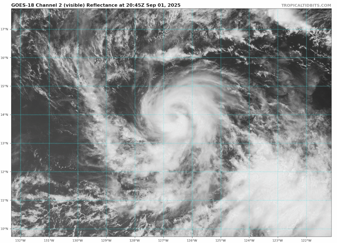
The satellite presentation of Kiko has changed little since the
previous advisory package. The cyclone appears to be in the process
of establishing a more well-defined inner-core structure, with
glimpses of an eye evident at times in visible satellite images.
The most recent subjective Dvorak current intensity estimates from
TAFB and SAB were 3.5/55 kt and 4.0/65 kt, respectively, while the
objective estimates from UW-CIMSS have ranged between 45 and 57 kt
during the past several hours. Taking a blend of these data, the
initial intensity for this advisory has been held at 55 kt.
Kiko is moving just south of due west, or 265 degrees, at 6 kt.
This general motion is expected to continue during the next several
days as the cyclone is steered by a building subtropical ridge to
its north and northwest. A turn toward the west-northwest is
forecast by days 4 and 5 as an upper-level trough north of Hawaii
begins to erode the western portion of the subtropical ridge. It
should be noted that there remains considerable along-track spread
among the global models — nearly 500 n mi by 120 hours — with the
CMC the farthest east, the UKMET the farthest west, and the
GFS/ECMWF solutions falling in between. The official track forecast
remains closely aligned with the latest multi-model consensus aids
and is slightly north of the previous advisory.
Kiko will remain over warm waters of 27–28C and influenced by mostly
light vertical wind shear through day 5. The surrounding
environmental mid-level moisture appears to be a limiting factor for
significant intensification, however, remaining between 50 and 60
percent and trending gradually lower through day 5. Additionally,
the slow-moving nature of Kiko and proximity to cooler waters to
the north of the system may also inhibit significant
intensification. The latest intensity guidance has trended lower,
and the official forecast reflects this change and has been nudged
down accordingly. The official intensity forecast remains higher
than most of the intensity guidance, and is most closely aligned
with a blend of the HCCA/FSSE intensity consensus aids and the
regional hurricane models.
FORECAST POSITIONS AND MAX WINDS
INIT 02/0300Z 13.8N 127.3W 55 KT 65 MPH
12H 02/1200Z 13.8N 128.1W 65 KT 75 MPH
24H 03/0000Z 13.8N 129.1W 75 KT 85 MPH
36H 03/1200Z 13.8N 130.2W 80 KT 90 MPH
48H 04/0000Z 13.9N 131.5W 85 KT 100 MPH
60H 04/1200Z 14.0N 133.0W 90 KT 105 MPH
72H 05/0000Z 14.2N 134.6W 90 KT 105 MPH
96H 06/0000Z 14.6N 137.7W 85 KT 100 MPH
120H 07/0000Z 15.5N 141.0W 80 KT 90 MPH
$$
Forecaster Jelsema (CPHC)
NWS National Hurricane Center Miami FL EP112025
500 PM HST Mon Sep 01 2025
The satellite presentation of Kiko has changed little since the
previous advisory package. The cyclone appears to be in the process
of establishing a more well-defined inner-core structure, with
glimpses of an eye evident at times in visible satellite images.
The most recent subjective Dvorak current intensity estimates from
TAFB and SAB were 3.5/55 kt and 4.0/65 kt, respectively, while the
objective estimates from UW-CIMSS have ranged between 45 and 57 kt
during the past several hours. Taking a blend of these data, the
initial intensity for this advisory has been held at 55 kt.
Kiko is moving just south of due west, or 265 degrees, at 6 kt.
This general motion is expected to continue during the next several
days as the cyclone is steered by a building subtropical ridge to
its north and northwest. A turn toward the west-northwest is
forecast by days 4 and 5 as an upper-level trough north of Hawaii
begins to erode the western portion of the subtropical ridge. It
should be noted that there remains considerable along-track spread
among the global models — nearly 500 n mi by 120 hours — with the
CMC the farthest east, the UKMET the farthest west, and the
GFS/ECMWF solutions falling in between. The official track forecast
remains closely aligned with the latest multi-model consensus aids
and is slightly north of the previous advisory.
Kiko will remain over warm waters of 27–28C and influenced by mostly
light vertical wind shear through day 5. The surrounding
environmental mid-level moisture appears to be a limiting factor for
significant intensification, however, remaining between 50 and 60
percent and trending gradually lower through day 5. Additionally,
the slow-moving nature of Kiko and proximity to cooler waters to
the north of the system may also inhibit significant
intensification. The latest intensity guidance has trended lower,
and the official forecast reflects this change and has been nudged
down accordingly. The official intensity forecast remains higher
than most of the intensity guidance, and is most closely aligned
with a blend of the HCCA/FSSE intensity consensus aids and the
regional hurricane models.
FORECAST POSITIONS AND MAX WINDS
INIT 02/0300Z 13.8N 127.3W 55 KT 65 MPH
12H 02/1200Z 13.8N 128.1W 65 KT 75 MPH
24H 03/0000Z 13.8N 129.1W 75 KT 85 MPH
36H 03/1200Z 13.8N 130.2W 80 KT 90 MPH
48H 04/0000Z 13.9N 131.5W 85 KT 100 MPH
60H 04/1200Z 14.0N 133.0W 90 KT 105 MPH
72H 05/0000Z 14.2N 134.6W 90 KT 105 MPH
96H 06/0000Z 14.6N 137.7W 85 KT 100 MPH
120H 07/0000Z 15.5N 141.0W 80 KT 90 MPH
$$
Forecaster Jelsema (CPHC)
0 likes
Visit the Caribbean-Central America Weather Thread where you can find at first post web cams,radars
and observations from Caribbean basin members Click Here
and observations from Caribbean basin members Click Here
-
Kingarabian
- S2K Supporter
- Posts: 16379
- Joined: Sat Aug 08, 2009 3:06 am
- Location: Honolulu, Hawaii
Re: EPAC: KIKO - Tropical Storm - Discussion
Confused why they backed off on intensity. Also why this isnt a hurricane yet when it had an eye feature for most of the day.
2 likes
RIP Kobe Bryant
-
cycloneye
- Admin
- Posts: 149730
- Age: 69
- Joined: Thu Oct 10, 2002 10:54 am
- Location: San Juan, Puerto Rico
Re: EPAC: KIKO - Hurricane - Discussion
BULLETIN
Hurricane Kiko Advisory Number 9
NWS National Hurricane Center Miami FL EP112025
1100 PM HST Mon Sep 01 2025
...KIKO BECOMES A HURRICANE...
SUMMARY OF 1100 PM HST...0900 UTC...INFORMATION
-----------------------------------------------
LOCATION...13.8N 127.9W
ABOUT 1840 MI...2965 KM E OF HILO HAWAII
MAXIMUM SUSTAINED WINDS...75 MPH...120 KM/H
PRESENT MOVEMENT...W OR 270 DEGREES AT 7 MPH...11 KM/H
MINIMUM CENTRAL PRESSURE...990 MB...29.24 INCHES
Hurricane Kiko Discussion Number 9
NWS National Hurricane Center Miami FL EP112025
1100 PM HST Mon Sep 01 2025
The satellite presentation of Kiko has improved since the previous
advisory, with what appears to be a developing inner-core and hints
of an eye evident at times in infrared satellite images. The most
recent subjective Dvorak current intensity estimates from TAFB and
SAB were both 4.0/65 kt. The objective estimates from UW-CIMSS have
ranged between 53 and 71 kt during the past several hours, and have
been trending upwards. Therefore, the initial intensity for this
advisory has been raised to 65 kt, making Kiko a category 1
hurricane.
Kiko is moving due west, or 270 degrees, at 6 kt. This general
motion is expected to continue during the next several days as the
cyclone is steered by a building subtropical ridge to its north and
northwest. A turn toward the west-northwest is forecast by days 4
and 5 as an upper-level trough north of Hawaii begins to erode the
western portion of the subtropical ridge. It should be noted that
there remains considerable along-track spread among the global
models, although the GFS and ECMWF day 5 positions have come into
much better agreement since the previous model cycle. The official
track forecast remains in good agreement with the latest multi-model
consensus aids and is very close to the previous advisory through 60
hours, then slightly to the north of the previous track forecast
from day 3 onward.
Kiko will remain over warm waters of 27–28C and influenced by mostly
light vertical wind shear through day 4. The surrounding
environmental mid-level moisture appears to be a somewhat limiting
factor for significant intensification, however, remaining between
50 and 60 percent through day 3, then trending below 50 percent by
days 4 and 5. The latest intensity guidance has trended
significantly higher from the previous model cycle, and the official
forecast reflects this change and has been nudged upward
accordingly. The official intensity forecast remains on the higher
end of the intensity guidance, and is most closely aligned with the
FSSE intensity consensus aid.
FORECAST POSITIONS AND MAX WINDS
INIT 02/0900Z 13.8N 127.9W 65 KT 75 MPH
12H 02/1800Z 13.8N 128.6W 75 KT 85 MPH
24H 03/0600Z 13.8N 129.6W 85 KT 100 MPH
36H 03/1800Z 13.8N 130.6W 90 KT 105 MPH
48H 04/0600Z 13.8N 131.8W 95 KT 110 MPH
60H 04/1800Z 14.0N 133.1W 95 KT 110 MPH
72H 05/0600Z 14.2N 134.5W 95 KT 110 MPH
96H 06/0600Z 15.0N 137.4W 85 KT 100 MPH
120H 07/0600Z 16.0N 140.4W 80 KT 90 MPH
$$
Forecaster Jelsema (CPHC)
0 likes
Visit the Caribbean-Central America Weather Thread where you can find at first post web cams,radars
and observations from Caribbean basin members Click Here
and observations from Caribbean basin members Click Here
-
Hurricane2022

- Category 5
- Posts: 2093
- Joined: Tue Aug 23, 2022 11:38 pm
- Location: Araçatuba, Brazil
Re: EPAC: KIKO - Hurricane - Discussion
The eye will likely be nice and clear later today or tomorrow.

3 likes
Sorry for the bad English sometimes...!
For reliable and detailed information for any meteorological phenomenon, please consult the National Hurricane Center, Joint Typhoon Warning Center , or your local Meteo Center.
--------
ECCE OMNIA NOVA FACIAM (Ap 21,5).
For reliable and detailed information for any meteorological phenomenon, please consult the National Hurricane Center, Joint Typhoon Warning Center , or your local Meteo Center.
--------
ECCE OMNIA NOVA FACIAM (Ap 21,5).
-
cycloneye
- Admin
- Posts: 149730
- Age: 69
- Joined: Thu Oct 10, 2002 10:54 am
- Location: San Juan, Puerto Rico
Re: EPAC: KIKO - Hurricane - Discussion
EP, 11, 2025090212, , BEST, 0, 138N, 1281W, 75, 987, HU
1 likes
Visit the Caribbean-Central America Weather Thread where you can find at first post web cams,radars
and observations from Caribbean basin members Click Here
and observations from Caribbean basin members Click Here
-
cycloneye
- Admin
- Posts: 149730
- Age: 69
- Joined: Thu Oct 10, 2002 10:54 am
- Location: San Juan, Puerto Rico
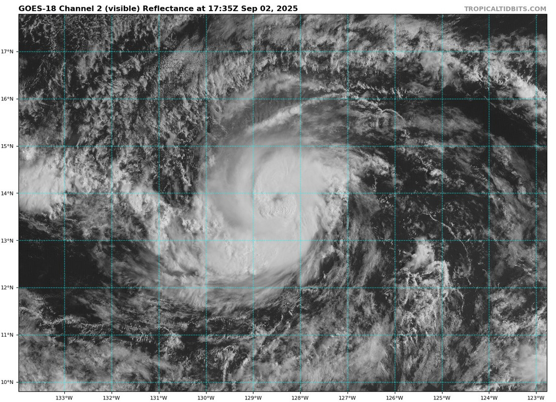
Re: EPAC: KIKO - Hurricane - Discussion
Kingarabian, Hurricane2022, now forecast to be a major cane.
BULLETIN
Hurricane Kiko Advisory Number 10
NWS National Hurricane Center Miami FL EP112025
500 AM HST Tue Sep 02 2025
...HURRICANE KIKO CONTINUES TO STRENGTHEN...
SUMMARY OF 500 AM HST...1500 UTC...INFORMATION
----------------------------------------------
LOCATION...13.8N 128.3W
ABOUT 1815 MI...2920 KM E OF HILO HAWAII
MAXIMUM SUSTAINED WINDS...85 MPH...140 KM/H
PRESENT MOVEMENT...W OR 270 DEGREES AT 6 MPH...9 KM/H
MINIMUM CENTRAL PRESSURE...987 MB...29.15 INCHES
Hurricane Kiko Discussion Number 10
NWS National Hurricane Center Miami FL EP112025
500 AM HST Tue Sep 02 2025
Over the past 6 hours, Kiko's eye has become apparent on nighttime
visible imagery, and at times it has also showed up in the infrared
imagery. The small hurricane is clearly intensifying. The latest
subjective Dvorak estimates from TAFB and SAB range from 77-90 kt,
while the UW-CIMSS objective estimates have been running in the
60-74 kt range. The initial intensity estimate of 75 kt represents
an average of these estimates.
Kiko continues moving slowly westward, or 270 degrees at 5 kt. The
main steering feature continues to be the subtropical ridge located
to the north of Kiko. A slow westward motion should continue for
the next couple of days. A turn toward the west-northwest is
forecast by days 3 and 4 as an upper-level trough north of Hawaii
begins to erode the western portion of the subtropical ridge. There
remains above normal along-track spread in the model suite, but not
as much spread as yesterday, and the day 5 positions of the GFS and
ECMWF are in fairly good agreement. The official day 5 position is
relatively close to an average of those models. Only minor
adjustments have been made to the official forecast, which lies
close to the TVCE consensus.
Through the next 48 h, Kiko should remain over sea-surface
temperatures of 27-28C, with light to moderate easterly wind shear
of 10-15 kt. The environmental air is a bit dry and stable, and
this might prevent rapid intensification. However, steady
strengthening still appears likely over the next day or two. By day
4, Kiko will reach somewhat cooler water temperatures as it moves
into a drier environment. The new NHC forecast shows a slightly
higher peak intensity of 100 kt, and is near the high end of the
intensity guidance suite through day 3. Some weakening is likely in
4-5 days when Kiko reaches the cooler water and drier air, but the
official forecast still maintains Kiko at hurricane strength through
day 5.
FORECAST POSITIONS AND MAX WINDS
INIT 02/1500Z 13.8N 128.3W 75 KT 85 MPH
12H 03/0000Z 13.8N 129.1W 90 KT 105 MPH
24H 03/1200Z 13.8N 130.2W 95 KT 110 MPH
36H 04/0000Z 13.8N 131.3W 100 KT 115 MPH
48H 04/1200Z 13.9N 132.6W 100 KT 115 MPH
60H 05/0000Z 14.1N 134.0W 100 KT 115 MPH
72H 05/1200Z 14.4N 135.4W 95 KT 110 MPH
96H 06/1200Z 15.3N 138.4W 85 KT 100 MPH
120H 07/1200Z 16.4N 141.6W 80 KT 90 MPH
$$
Forecaster Hagen
1 likes
Visit the Caribbean-Central America Weather Thread where you can find at first post web cams,radars
and observations from Caribbean basin members Click Here
and observations from Caribbean basin members Click Here
-
DorkyMcDorkface

- Category 5
- Posts: 1044
- Age: 28
- Joined: Mon Sep 30, 2019 1:32 pm
- Location: Mid-Atlantic
Re: EPAC: KIKO - Hurricane - Discussion

1 likes
Please note the thoughts expressed by this account are solely those of the user and are from a hobbyist perspective. For more comprehensive analysis, consult an actual professional meteorologist or meteorological agency.
Floyd 1999 | Isabel 2003 | Hanna 2008 | Irene 2011 | Sandy 2012 | Isaias 2020
-
Kingarabian
- S2K Supporter
- Posts: 16379
- Joined: Sat Aug 08, 2009 3:06 am
- Location: Honolulu, Hawaii
Re: EPAC: KIKO - Hurricane - Discussion
Still dealing with dry air entrainment.
0 likes
RIP Kobe Bryant
-
Kingarabian
- S2K Supporter
- Posts: 16379
- Joined: Sat Aug 08, 2009 3:06 am
- Location: Honolulu, Hawaii
Re: EPAC: KIKO - Hurricane - Discussion
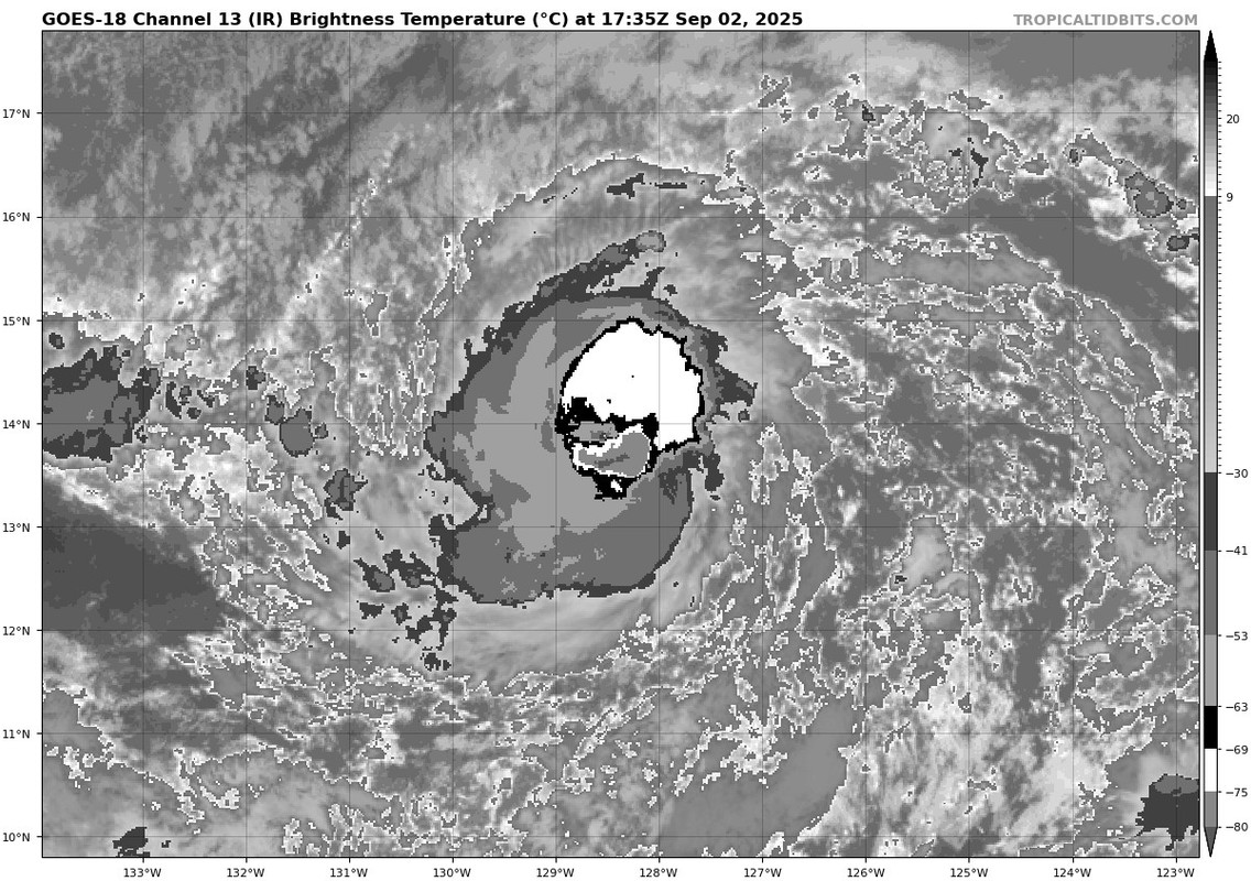
Thin B ring west of the eye. W ring 3/4 complete.
2 likes
RIP Kobe Bryant
-
Kingarabian
- S2K Supporter
- Posts: 16379
- Joined: Sat Aug 08, 2009 3:06 am
- Location: Honolulu, Hawaii
Re: EPAC: KIKO - Hurricane - Discussion
T5.0 on Dvorak.
SAB supports this:
ADT raw's just jumped to T5.2. CI is lower due to constraints since it had a really hard time fixing the eye over the past 24 hours.
SAB supports this:
TXPZ26 KNES 021219
TCSENP
A. 11E (KIKO)
B. 02/1200Z
C. 13.8N
D. 128.1W
E. ONE/GOES-W
F. T5.0/5.0
G. IR/EIR/PRXY/MHS
H. REMARKS...DG EYE IS EMBEDDED AND SURROUNDED BY LG RESULTING IN A DT
OF 5.0. NOTHING ADDED FOR EYE ADJUSTMENT. MET AND PT = 5.0. THE FT IS
BASED ON THE DT.
I. ADDL POSITIONS
02/0606Z 13.8N 127.6W MHS
...KIBLER
ADT raw's just jumped to T5.2. CI is lower due to constraints since it had a really hard time fixing the eye over the past 24 hours.
0 likes
RIP Kobe Bryant
-
Sciencerocks
- Category 5
- Posts: 10193
- Age: 40
- Joined: Thu Jul 06, 2017 1:51 am


-
Kingarabian
- S2K Supporter
- Posts: 16379
- Joined: Sat Aug 08, 2009 3:06 am
- Location: Honolulu, Hawaii
Re: EPAC: KIKO - Hurricane - Discussion
Cyan ring + pink ring combo.
I would go with 85 to 90kts with that presentation.
0 likes
RIP Kobe Bryant
-
cycloneye
- Admin
- Posts: 149730
- Age: 69
- Joined: Thu Oct 10, 2002 10:54 am
- Location: San Juan, Puerto Rico
Re: EPAC: KIKO - Hurricane - Discussion
EP, 11, 2025090218, , BEST, 0, 138N, 1286W, 75, 987, HU
0 likes
Visit the Caribbean-Central America Weather Thread where you can find at first post web cams,radars
and observations from Caribbean basin members Click Here
and observations from Caribbean basin members Click Here
Who is online
Users browsing this forum: No registered users and 29 guests