
EPAC: LORENA - Post-Tropical - Discussion
Moderator: S2k Moderators
-
Sciencerocks
- Category 5

- Posts: 10181
- Age: 40
- Joined: Thu Jul 06, 2017 1:51 am
-
TomballEd
- Category 5
- Posts: 1264
- Age: 62
- Joined: Wed Aug 16, 2023 4:52 pm
- Location: Spring/Klein area, not Tomball
Re: EPAC: LORENA - Tropical Storm - Discussion
Over a month early and likely not a strong Cat 2 like Hurricane Rosa, but the modeled path, a storm stripped of its LL circulation crossing the mountains but having an MLC with tropical moisture above the surface, rain threat for CONUS?
0 likes
-
vbhoutex

- Storm2k Executive

- Posts: 29145
- Age: 74
- Joined: Wed Oct 09, 2002 11:31 pm
- Location: Cypress, TX
- Contact:
Re: EPAC: LORENA - Tropical Storm - Discussion
TomballEd wrote:Over a month early and likely not a strong Cat 2 like Hurricane Rosa, but the modeled path, a storm stripped of its LL circulation crossing the mountains but having an MLC with tropical moisture above the surface, rain threat for CONUS?
I presume you've seen our local ocm and others in thee state are suggesting we will have a problem in Texas. I would expect it is a strong possibility.
1 likes
Skywarn, C.E.R.T.
Please click below to donate to STORM2K to help with the expenses of keeping the site going:

Please click below to donate to STORM2K to help with the expenses of keeping the site going:
-
cycloneye

- Admin
- Posts: 149278
- Age: 69
- Joined: Thu Oct 10, 2002 10:54 am
- Location: San Juan, Puerto Rico
Re: EPAC: LORENA - Tropical Storm - Discussion
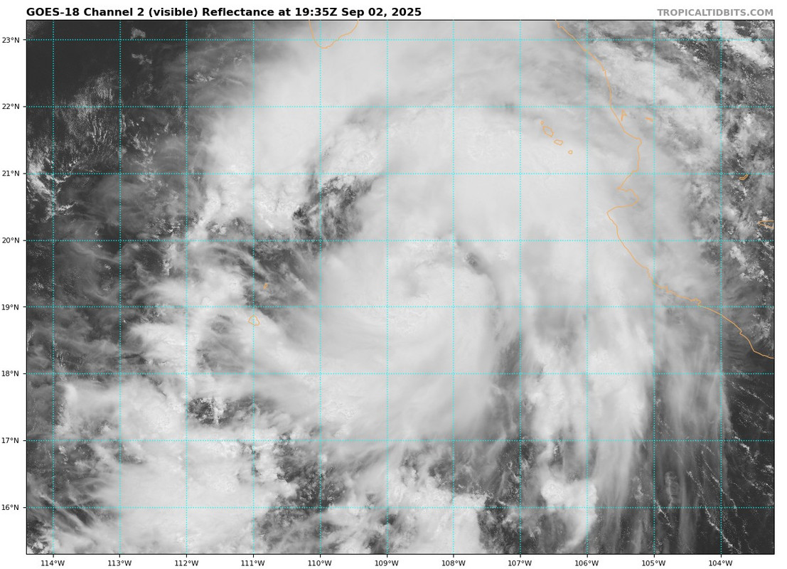
EP, 12, 2025090218, , BEST, 0, 189N, 1083W, 45, 1002, TS
0 likes
Visit the Caribbean-Central America Weather Thread where you can find at first post web cams,radars
and observations from Caribbean basin members Click Here
and observations from Caribbean basin members Click Here
-
Kingarabian

- S2K Supporter

- Posts: 16348
- Joined: Sat Aug 08, 2009 3:06 am
- Location: Honolulu, Hawaii
Re: EPAC: LORENA - Tropical Storm - Discussion
vbhoutex wrote:TomballEd wrote:Over a month early and likely not a strong Cat 2 like Hurricane Rosa, but the modeled path, a storm stripped of its LL circulation crossing the mountains but having an MLC with tropical moisture above the surface, rain threat for CONUS?
I presume you've seen our local ocm and others in thee state are suggesting we will have a problem in Texas. I would expect it is a strong possibility.
This thing is massive. GFS has the remnants of Lorena moving slowly over Texas with an abundant amount of moisture.
0 likes
RIP Kobe Bryant
-
Kingarabian
- S2K Supporter
- Posts: 16348
- Joined: Sat Aug 08, 2009 3:06 am
- Location: Honolulu, Hawaii
-
cycloneye
- Admin
- Posts: 149278
- Age: 69
- Joined: Thu Oct 10, 2002 10:54 am
- Location: San Juan, Puerto Rico
Re: EPAC: LORENA - Tropical Storm - Discussion
BULLETIN
Tropical Storm Lorena Advisory Number 4
NWS National Hurricane Center Miami FL EP122025
Issued by the NWS Weather Prediction Center College Park MD
200 PM MST Tue Sep 02 2025
...TROPICAL STORM LORENA STRENGTHENING AND FORECAST TO BECOME A
HURRICANE TOMORROW...
...TROPICAL STORM WATCHES ISSUES FOR WESTERN PORTION OF BAJA
CALIFORNIA SUR...
SUMMARY OF 200 PM MST...2100 UTC...INFORMATION
----------------------------------------------
LOCATION...19.4N 109.0W
ABOUT 310 MI...495 KM W OF MANZANILLO MEXICO
ABOUT 250 MI...400 KM SSE OF CABO SAN LUCAS MEXICO
MAXIMUM SUSTAINED WINDS...50 MPH...85 KM/H
PRESENT MOVEMENT...NW OR 310 DEGREES AT 15 MPH...24 KM/H
MINIMUM CENTRAL PRESSURE...1002 MB...29.59 INCHES
WATCHES AND WARNINGS
--------------------
CHANGES WITH THIS ADVISORY:
The government of Mexico has issued a Tropical Storm Watch from Cabo
San Lucas northward to Cabo San Lazaro on the western coast of Baja
California Sur.
SUMMARY OF WATCHES AND WARNINGS IN EFFECT:
A Tropical Storm Watch is in effect for...
* Cabo San Lucas northward to Cabo San Lazaro on the western coast
of Baja California Sur in Mexico.
A Tropical Storm Watch means that tropical storm conditions are
possible within the watch area, generally within 48 hours.
Interests elsewhere in southwestern Mexico and the Baja California
peninsula should monitor the progress of this system. Additional
watches may be required later tonight or on Wednesday.
Tropical Storm Lorena Discussion Number 4
NWS National Hurricane Center Miami FL EP122025
Issued by the NWS Weather Prediction Center College Park MD
200 PM MST Tue Sep 02 2025
A 1548z METOP-B ASCAT pass provided solid coverage of Lorena's
overall wind field with also resulted in a northward adjustment to
the initial position. Since the ASCAT pass, GOES-East visible
imagery continues to show improving overall organization within an
ideal environment for further strengthening. Symmetric banding
features support Dvorak DT numbers of 3.0 and 3.5 from TAFB and SAB,
respectively. The recent inner core convection bursting with cloud
tops below -80C further suggest a strengthening trend, even without
recent microwave imagery to analyze its inner core structure. The
initial intensity is set at 45 kt, as a blend of the two operational
Dvorak estimates, along with other objective intensity estimates.
Since the prior advisory, Lorena is moving a bit faster at 13 kt to
the northwest as its being steered by the southwestern periphery of
the larger scale mid-level ridge. With the small northward
readjustment of position, the northwestward track will continue
through the next 48 hours, but this brings the center and wind field
closer to Baja California compared to the prior track forecast. As
such, the overall forecast track is a bit faster and shifted north
and east relative to prior forecast, following trends in the latest
track guidance. Due to the uncertainty that Tropical Storm force
winds may affect areas along the southwestern coasts of Baja
California Sur, the Government of Mexico has issued Tropical Storm
Watches from Cabo San Lucas northward to Cabo San Lazaro. Any
further deviations north and/or eastward may result in further
expansion of watches and/or warning conditions over the next 24 to
48 hours. Deep layer vertical shear and overall decaying
sea-surface environment will slow the forward speed, with slow
recurvature expected after 48 hours west of Baja California Sur.
The shear results in an expanding track forecast suite, though will
continue to prior trends and overall means recurving the cyclone
toward the central Baja California with initial landfall forecast
after 72 hours. What remains of the circulation will cross the
Peninsula tracking northeast with a second landfall along coastal
Sonora towards the end of the forecast period.
Lorena is expected to remain fairly small inner core, though with
ample moisture and warm sea-surface temperatures for the next 24 to
36 h, forecasts are for steady intensification toward hurricane
status by Wednesday. There is some potential that Lorena may rapidly
intensify in the short term given its structure and favorable
environment. As Lorena crosses the 26 C isotherm in 2-3 days,
vertical wind shear will also increase and the overall intensity
should start to weaken by late in the week. As the cyclone turns
northeastward, slow weakening is expected with eventual dissipation
over Sonora by Saturday. The intensity forecast is on the higher
end of the guidance envelope.
Key Messages:
1. Heavy rainfall associated with Tropical Storm Lorena will begin
to affect Baja California Sur on Wednesday, and southwestern Sonora
by Thursday. This will increase the risk of life-threatening flash
floods and mudslides, especially in areas of higher terrain.
2. Lorena is forecast to approach the Baja California peninsula
later this week. Due to the uncertainty that Tropical Storm force
winds may affect areas along the southwestern coasts of Baja
California Sur, the Government of Mexico has issued Tropical Storm
Watches from Cabo San Lucas northward to Cabo San Lazaro. Residents
should closely monitor the latest forecast updates and ensure that
they have their preparedness plan in place.
FORECAST POSITIONS AND MAX WINDS
INIT 02/2100Z 19.4N 109.0W 45 KT 50 MPH
12H 03/0600Z 20.6N 110.4W 55 KT 65 MPH
24H 03/1800Z 21.8N 112.0W 65 KT 75 MPH
36H 04/0600Z 22.9N 113.1W 75 KT 85 MPH
48H 04/1800Z 24.1N 113.8W 70 KT 80 MPH
60H 05/0600Z 25.1N 113.8W 55 KT 65 MPH
72H 05/1800Z 26.2N 113.3W 45 KT 50 MPH
96H 06/1800Z 28.4N 111.8W 35 KT 40 MPH
120H 07/1800Z 29.9N 110.3W 25 KT 30 MPH...POST-TROP/REMNT LOW
$$
Forecaster Gallina/Papin
0 likes
Visit the Caribbean-Central America Weather Thread where you can find at first post web cams,radars
and observations from Caribbean basin members Click Here
and observations from Caribbean basin members Click Here
-
Sciencerocks
- Category 5
- Posts: 10181
- Age: 40
- Joined: Thu Jul 06, 2017 1:51 am

-
cycloneye
- Admin
- Posts: 149278
- Age: 69
- Joined: Thu Oct 10, 2002 10:54 am
- Location: San Juan, Puerto Rico
Re: EPAC: LORENA - Tropical Storm - Discussion
BULLETIN
Tropical Storm Lorena Intermediate Advisory Number 4A
NWS National Hurricane Center Miami FL EP122025
500 PM MST Tue Sep 02 2025
...LORENA STRENGTHENING...
SUMMARY OF 500 PM MST...0000 UTC...INFORMATION
----------------------------------------------
LOCATION...19.8N 109.2W
ABOUT 220 MI...350 KM SSE OF CABO SAN LUCAS MEXICO
ABOUT 230 MI...370 KM W OF CABO CORRIENTES MEXICO
MAXIMUM SUSTAINED WINDS...60 MPH...95 KM/H
PRESENT MOVEMENT...NW OR 315 DEGREES AT 15 MPH...24 KM/H
MINIMUM CENTRAL PRESSURE...999 MB...29.50 INCHES
SUMMARY OF WATCHES AND WARNINGS IN EFFECT:
A Tropical Storm Watch is in effect for...
* West Coast of Baja California Sur from Cabo San Lucas northward
to Cabo San Lazaro
A Tropical Storm Watch means that tropical storm conditions are
possible within the watch area, generally within 48 hours.
Interests elsewhere in southwestern Mexico and the Baja California
peninsula should monitor the progress of this system. Additional
watches may be required later tonight or on Wednesday.
0 likes
Visit the Caribbean-Central America Weather Thread where you can find at first post web cams,radars
and observations from Caribbean basin members Click Here
and observations from Caribbean basin members Click Here
-
cycloneye
- Admin
- Posts: 149278
- Age: 69
- Joined: Thu Oct 10, 2002 10:54 am
- Location: San Juan, Puerto Rico
Re: EPAC: LORENA - Tropical Storm - Discussion
EP, 12, 2025090300, , BEST, 0, 198N, 1092W, 55, 997, TS
0 likes
Visit the Caribbean-Central America Weather Thread where you can find at first post web cams,radars
and observations from Caribbean basin members Click Here
and observations from Caribbean basin members Click Here
-
cycloneye
- Admin
- Posts: 149278
- Age: 69
- Joined: Thu Oct 10, 2002 10:54 am
- Location: San Juan, Puerto Rico
Re: EPAC: LORENA - Tropical Storm - Discussion
BULLETIN
Tropical Storm Lorena Advisory Number 5
NWS National Hurricane Center Miami FL EP122025
800 PM MST Tue Sep 02 2025
...LORENA COULD RAPIDLY INTENSIFY THROUGH WEDNESDAY...
SUMMARY OF 800 PM MST...0300 UTC...INFORMATION
----------------------------------------------
LOCATION...20.2N 109.7W
ABOUT 185 MI...300 KM S OF CABO SAN LUCAS MEXICO
ABOUT 260 MI...415 KM W OF CABO CORRIENTES MEXICO
MAXIMUM SUSTAINED WINDS...65 MPH...100 KM/H
PRESENT MOVEMENT...NW OR 315 DEGREES AT 14 MPH...22 KM/H
MINIMUM CENTRAL PRESSURE...997 MB...29.44 INCHES
SUMMARY OF WATCHES AND WARNINGS IN EFFECT:
A Tropical Storm Watch is in effect for...
* West Coast of Baja California Sur from Cabo San Lucas northward
to Cabo San Lazaro
A Tropical Storm Watch means that tropical storm conditions are
possible within the watch area, generally within 48 hours.
Interests elsewhere on the Baja California peninsula and in
southwestern Mexico should monitor the progress of Lorena.
Additional watches or warnings may be required on Wednesday.
Tropical Storm Lorena Discussion Number 5
NWS National Hurricane Center Miami FL EP122025
800 PM MST Tue Sep 02 2025
A pair of AMSR2 and GMI microwave passes from several hours ago
revealed that Lorena's structure has improved significantly through
the day, with the 37-GHZ channel in particular showing a
well-defined cyan ring. The center is embedded beneath a Central
Dense Overcast, and Dvorak intensity estimates from TAFB and SAB
are a consensus T3.5/55 kt. This is also supported by some of the
UW-CIMSS objective numbers, and the initial intensity is therefore
set--possibly conservatively given the structure--at 55 kt.
Lorena has a low-level structure and small size that would make it
a prime suspect for rapid intensification, especially since it will
be in an environment of low shear and over warm ocean temperatures
for the next 36 hours. In fact, the SHIPS Rapid Intensification
(RI) index now shows a 3 in 4 chance of a 30-kt increase in
Lorena's winds over the next 24 hours. The NHC intensity forecast
therefore explicitly shows RI during the next day or so and most
closely follows the SHIPS and LGEM models, which are the highest
guidance, during that time. After 36 hours, increasing shear and
colder water temperatures are expected lead to weakening, which
itself could be rapid due to Lorena's small size. Although there
is significant uncertainty on where Lorena will end up in 4-5 days
(see discussion below), the cyclone will likely not exist anymore
by day 5, and that is when dissipation is shown in the forecast.
Lorena continues to move northwestward, or 315/12 kt. The first 36
hours or so of the track forecast are fairly straightforward, with
a slower northwestward motion expected while the cyclone moves
around the western periphery of a mid-level high centered over
Mexico. Things are trickier after 36 hours. Lorena will be moving
through a weakness in the subtropical ridge, but how much northward
progress it makes will depend on how long it remains strong. A
minority of models, particularly the GFS, keep a stronger Lorena
moving northeastward across the Baja California peninsula toward
Sonora. However, moderate to strong southwesterly shear is likely
to set in over Lorena in 48-72 hours, and a good chunk of the other
models, including many of the GEFS ensemble members, keep a
weakening Lorena offshore the west coast of the Baja California
peninsula with landfall never occurring. This new NHC forecast
blends the previous official forecast with the latest HCCA, Florida
State Superensemble, and GEFS ensemble mean, showing a slower
motion on day 4 and 5, and introducing the possibility that Lorena
doesn't reach mainland Mexico as a tropical cyclone.
Key Messages:
1. Heavy rainfall associated with Tropical Storm Lorena will begin
to affect Baja California Sur on Wednesday, southwestern Sonora by
Thursday, and contribute to heavy rainfall concerns across Arizona
late Wednesday through Friday. This will increase the risk of
life-threatening flash floods and mudslides across Mexico,
especially in areas of higher terrain. Isolated to scattered
instances of flash flooding are possible across Arizona through
Friday.
2. Although rapid intensification is possible through Wednesday
while Lorena is offshore, the storm is expected to weaken while it
approaches the Baja California peninsula on Thursday and Friday.
Regardless, tropical storm conditions are possible through Thursday
along portions of the west coast of Baja California Sur.
Interests in Baja California Sur should closely monitor the latest
forecast updates.
FORECAST POSITIONS AND MAX WINDS
INIT 03/0300Z 20.2N 109.7W 55 KT 65 MPH
12H 03/1200Z 21.2N 111.1W 70 KT 80 MPH
24H 04/0000Z 22.3N 112.6W 85 KT 100 MPH
36H 04/1200Z 23.4N 113.5W 90 KT 105 MPH
48H 05/0000Z 24.6N 113.9W 75 KT 85 MPH
60H 05/1200Z 25.6N 113.8W 55 KT 65 MPH
72H 06/0000Z 26.6N 113.3W 40 KT 45 MPH
96H 07/0000Z 28.1N 112.4W 25 KT 30 MPH...POST-TROP/REMNT LOW
120H 08/0000Z...DISSIPATED
$$
Forecaster Berg
0 likes
Visit the Caribbean-Central America Weather Thread where you can find at first post web cams,radars
and observations from Caribbean basin members Click Here
and observations from Caribbean basin members Click Here
-
Hurricane2022

- Category 5
- Posts: 2016
- Joined: Tue Aug 23, 2022 11:38 pm
- Location: Araçatuba, Brazil
Re: EPAC: LORENA - Tropical Storm - Discussion
...and the initial intensity is therefore set--possibly
conservatively given the structure--at 55 kt.
conservatively given the structure--at 55 kt.
The SHIPS Rapid Intensification (RI) index now shows a 3 in 4
chance of a 30-kt increase in Lorena's winds over the next 24 hours.
The NHC intensity forecast therefore explicitly shows RI during the
next day or so...
chance of a 30-kt increase in Lorena's winds over the next 24 hours.
The NHC intensity forecast therefore explicitly shows RI during the
next day or so...
Barring any unexpected shear or dry air intrusion, I fully expect Lorena to become a (low-end) major now.
4 likes
Sorry for the bad English sometimes...!
For reliable and detailed information for any meteorological phenomenon, please consult the National Hurricane Center, Joint Typhoon Warning Center , or your local Meteo Center.
--------
ECCE OMNIA NOVA FACIAM (Ap 21,5).
For reliable and detailed information for any meteorological phenomenon, please consult the National Hurricane Center, Joint Typhoon Warning Center , or your local Meteo Center.
--------
ECCE OMNIA NOVA FACIAM (Ap 21,5).
-
cycloneye
- Admin
- Posts: 149278
- Age: 69
- Joined: Thu Oct 10, 2002 10:54 am
- Location: San Juan, Puerto Rico
Re: EPAC: LORENA - Hurricane - Discussion
BULLETIN
Hurricane Lorena Advisory Number 6
NWS National Hurricane Center Miami FL EP122025
200 AM MST Wed Sep 03 2025
...LORENA BECOMES A HURRICANE...
...NEW WARNINGS AND WATCHES ISSUED FOR BAJA CALIFORNIA SUR...
SUMMARY OF 200 AM MST...0900 UTC...INFORMATION
----------------------------------------------
LOCATION...21.2N 110.4W
ABOUT 120 MI...195 KM SSW OF CABO SAN LUCAS MEXICO
ABOUT 275 MI...445 KM SSE OF CABO SAN LAZARO MEXICO
MAXIMUM SUSTAINED WINDS...75 MPH...120 KM/H
PRESENT MOVEMENT...NW OR 320 DEGREES AT 14 MPH...22 KM/H
MINIMUM CENTRAL PRESSURE...990 MB...29.24 INCHES
Hurricane Lorena Discussion Number 6
NWS National Hurricane Center Miami FL EP122025
200 AM MST Wed Sep 03 2025
Satellite imagery and data from the Mexican radar at Cabo San Lucas
indicate that Lorena continues to become better organized, with the
radar imagery showing an eyewall wrapped 50-70 percent of the way
around the center. Satellite intensity estimates are now in the
55-65 kt range, with subjective estimates from TAFB and SAB being
65 kt. Based on these data, the initial intensity is increased to
65 kt and Lorena is upgraded to a hurricane.
Steady to rapid intensification is likely during the next 24 h,
and while the forecast peak intensity of 85 kt is above the upper
edge of the intensity guidance it might be conservative. After
that time, Lorena is forecast to move over cooler sea surface
temperatures and into an area of southwesterly vertical shear.
This should cause significant weakening, and Lorena is expected to
weaken back to a tropical storm by 60 h. There is significant
uncertainty as to whether Lorena will make landfall in Baja
California Sur (see discussion below). If it does, the system
should continue weakening and dissipate over northwestern Mexico by
120 h. If it doesn't, the cyclone should continue to weaken over
cold water, with dissipation likely west of Baja California Sur
by 120 h.
The initial motion is now 320/12 kt. The first 24 h or so of
the track forecast remain fairly straightforward, with a slower
northwestward motion expected while the cyclone moves around the
western periphery of a mid-level high centered over Mexico. After
that time, Lorena will be moving into a weakness in the subtropical
ridge as it starts to encounter the less favorable environment.
The GFS model maintains a stronger and deeper Lorena and breaks open
the weakness in about 36 h, allowing the cyclone to recurve
north-northeastward into northwestern Mexico. The ECMWF and
Canadian models have a weaker Lorena and take about 12 h longer to
break open the ridge. This results in Lorena shearing apart with
the low-level center turning westward over the Pacific west of Baja
California Sur. Based on current intensity trends, the track
forecast leans toward the GFS solution and shows Lorena crossing
Baja California Sur in 60-72 h. However, there is still the
possibility that the cyclone does not reach the coast of Mexico. The
new forecast track is similar to the previous track and lies along
the east side of the consensus models.
Key Messages:
1. Heavy rainfall associated with Tropical Storm Lorena will
continue to impact Baja California Sur, moving into southeastern
Baja California and southwestern Sonora by Thursday, and contribute
to heavy rainfall concerns across Arizona late Wednesday through
Friday. This will increase the risk of life-threatening flash floods
and mudslides across Mexico, especially in areas of higher terrain.
Isolated to scattered instances of flash flooding are possible
across Arizona through Friday.
2. Although rapid intensification is possible through tonight while
Lorena is offshore, the storm is expected to weaken while it
approaches the Baja California peninsula on Thursday and Thursday
night. Regardless, tropical storm conditions are likely along
portions of the coast of Baja California Sur where a Tropical Storm
Warning has been issued. Tropical Storm conditions are also
possible through Friday along other portions of the west coast of
Baja California Sur where a Tropical Storm Watch is in effect.
Interests in Baja California Sur should closely monitor the latest
forecast updates.
FORECAST POSITIONS AND MAX WINDS
INIT 03/0900Z 21.2N 110.4W 65 KT 75 MPH
12H 03/1800Z 22.2N 111.7W 75 KT 85 MPH
24H 04/0600Z 23.2N 113.0W 85 KT 100 MPH
36H 04/1800Z 24.2N 113.7W 80 KT 90 MPH
48H 05/0600Z 25.3N 113.9W 65 KT 75 MPH
60H 05/1800Z 26.4N 113.7W 50 KT 60 MPH
72H 06/0600Z 27.4N 113.3W 35 KT 40 MPH
96H 07/0600Z 29.5N 111.0W 20 KT 25 MPH...POST-TROP/REMNT LOW
120H 08/0600Z...DISSIPATED
$$
Forecaster Beven
0 likes
Visit the Caribbean-Central America Weather Thread where you can find at first post web cams,radars
and observations from Caribbean basin members Click Here
and observations from Caribbean basin members Click Here
-
cycloneye
- Admin
- Posts: 149278
- Age: 69
- Joined: Thu Oct 10, 2002 10:54 am
- Location: San Juan, Puerto Rico
Re: EPAC: LORENA - Hurricane - Discussion
BULLETIN
Hurricane Lorena Intermediate Advisory Number 6A
NWS National Hurricane Center Miami FL EP122025
500 AM MST Wed Sep 03 2025
...HEAVY RAINFALL AND LIFE-THREATENING FLASH FLOODING SPREADING
NORTHWARD ACROSS BAJA CALIFORNIA SUR...
SUMMARY OF 500 AM MST...1200 UTC...INFORMATION
----------------------------------------------
LOCATION...21.9N 111.1W
ABOUT 105 MI...165 KM SW OF CABO SAN LUCAS MEXICO
ABOUT 215 MI...345 KM SSE OF CABO SAN LAZARO MEXICO
MAXIMUM SUSTAINED WINDS...75 MPH...120 KM/H
PRESENT MOVEMENT...NW OR 320 DEGREES AT 15 MPH...24 KM/H
MINIMUM CENTRAL PRESSURE...990 MB...29.24 INCHES
0 likes
Visit the Caribbean-Central America Weather Thread where you can find at first post web cams,radars
and observations from Caribbean basin members Click Here
and observations from Caribbean basin members Click Here
-
Sciencerocks
- Category 5
- Posts: 10181
- Age: 40
- Joined: Thu Jul 06, 2017 1:51 am

-
cycloneye
- Admin
- Posts: 149278
- Age: 69
- Joined: Thu Oct 10, 2002 10:54 am
- Location: San Juan, Puerto Rico
Re: EPAC: LORENA - Hurricane - Discussion
BULLETIN
Hurricane Lorena Advisory Number 7
NWS National Hurricane Center Miami FL EP122025
800 AM MST Wed Sep 03 2025
...LORENA CONTINUES TO STRENGTHEN...
...HEAVY RAINFALL AND LIFE-THREATENING FLASH FLOODING SPREADING
NORTHWARD ACROSS BAJA CALIFORNIA SUR...
SUMMARY OF 800 AM MST...1500 UTC...INFORMATION
----------------------------------------------
LOCATION...22.3N 111.6W
ABOUT 115 MI...185 KM WSW OF CABO SAN LUCAS MEXICO
ABOUT 180 MI...285 KM SSE OF CABO SAN LAZARO MEXICO
MAXIMUM SUSTAINED WINDS...80 MPH...130 KM/H
PRESENT MOVEMENT...NW OR 320 DEGREES AT 16 MPH...26 KM/H
MINIMUM CENTRAL PRESSURE...988 MB...29.18 INCHES
Hurricane Lorena Discussion Number 7
NWS National Hurricane Center Miami FL EP122025
800 AM MST Wed Sep 03 2025
Satellite imagery and radar data from the Los Cabos radar in Mexico
indicate that Lorena continues to become better organized. Radar
imagery shows Lorena's eye becoming better defined, with a
completely closed and circular eyewall. Dvorak estimates from TAFB
and SAB were both T-4.0/65 kt, with the UW-CIMSS numbers ranging
from 55-68 kt. However, the improvement over the last few hours
seen in radar images and GOES West satellite images suggest that
Lorena is likely stronger now. The initial intensity is estimated
at 70 kt, and it is possible this may be a bit conservative. An Air
Force Reserve reconnaissance aircraft is currently enroute to
Lorena, which should provide a better estimate of the intensity
in a couple of hours from now.
Lorena has rapidly intensified over the past 24 hours. Continued
rapid strengthening is likely for another 12 to 18 hours as Lorena
remains over warm water and in low wind shear conditions, and the
peak intensity forecast of 85 kt is maintained. By 24 hours, the
hurricane is expected to cross the 26C sea-surface temperature
isotherm while southwesterly wind shear also begins to significantly
increase. These conditions are expected to lead to rapid weakening
beginning by Thursday afternoon. The official forecast is above
most of the intensity guidance for the first 24 hours, but is closer
to the consensus aids thereafter.
The initial motion is faster now toward the northwest, or 320/14 kt.
Not much has changed with the track forecast reasoning. There are
still two camps of models. The majority of the guidance, including
the GFS, shows Lorena progressing faster and farther east, with
landfall in Baja California Sur followed by a turn toward the
northeast. But a significant minority of models, including the
ECMWF, CMC, and UKMET, slow down Lorena immediately, with a track
farther west, and then dissipate the system over water without
making landfall. The steering is such that a stronger cyclone would
be more likely to be in the faster and farther east camp of models.
However, if the hurricane rapidly weakens by Thursday night and
starts to decouple due to the aforementioned increasing
southwesterly shear, then the low-level circulation could
potentially get left behind. The new NHC forecast shows a faster
forward motion over the next 36 hours with a track slightly to the
right of the previous NHC track. Due to the rightward shift, the
chance of tropical storm force winds impacting portions of Baja
California Sur is increasing. Additionally, there is very high
confidence that heavy rainfall amounts leading to significant
flooding will occur in Baja California Sur, especially since the
southwesterly upper-level winds favor deep convection to the right
side of Lorena by late Thursday. At 48 h and beyond, the new NHC
forecast is similar to, but slightly to the left of, the previous
NHC forecast track.
Key Messages:
1. Heavy rainfall associated with Tropical Storm Lorena will
continue to impact Baja California Sur, moving into southeastern
Baja California and southwestern Sonora by Thursday, and
contributing to heavy rainfall concerns across Arizona from late
Wednesday through Friday. This will increase the risk of
life-threatening flash floods and mudslides across Mexico,
especially in areas of higher terrain. Isolated to scattered
instances of flash flooding are possible across Arizona through
Friday.
2. The center of Lorena is forecast to move parallel to, but
offshore of, the southwest coast of the Baja Peninsula today, and
then move closer to the west-central coast of the peninsula on
Thursday. Regardless of the exact track, tropical storm conditions
are likely along portions of the coast of Baja California Sur where
a Tropical Storm Warning has been issued. Tropical Storm conditions
are also possible through tonight along the southwestern coast of
Baja California Sur where a Tropical Storm Watch is in effect.
Interests elsewhere in Baja California Sur should closely monitor
the latest forecast updates.
3. Life-threatening surf and rip current conditions will affect
portions of the southern and western coasts of Baja California Sur
during the next couple of days.
FORECAST POSITIONS AND MAX WINDS
INIT 03/1500Z 22.3N 111.6W 70 KT 80 MPH
12H 04/0000Z 23.4N 112.7W 85 KT 100 MPH
24H 04/1200Z 24.5N 113.7W 80 KT 90 MPH
36H 05/0000Z 25.6N 113.9W 65 KT 75 MPH
48H 05/1200Z 26.4N 113.9W 50 KT 60 MPH
60H 06/0000Z 27.5N 113.5W 40 KT 45 MPH
72H 06/1200Z 28.4N 112.8W 35 KT 40 MPH
96H 07/1200Z 30.4N 110.6W 20 KT 25 MPH...POST-TROP/REMNT LOW
120H 08/1200Z...DISSIPATED
$$
Forecaster Hagen
0 likes
Visit the Caribbean-Central America Weather Thread where you can find at first post web cams,radars
and observations from Caribbean basin members Click Here
and observations from Caribbean basin members Click Here
-
WaveBreaking

- Category 2

- Posts: 717
- Joined: Sun Jun 30, 2024 11:33 am
- Location: US
Re: EPAC: LORENA - Hurricane - Discussion
Dual VHTs. Have a feeling Lorena’s about to go above and beyond the intensity forecast.

2 likes
I am NOT a professional meteorologist, so take all of my posts with a grain of salt. My opinions are mine and mine alone.
-
cycloneye
- Admin
- Posts: 149278
- Age: 69
- Joined: Thu Oct 10, 2002 10:54 am
- Location: San Juan, Puerto Rico
Re: EPAC: LORENA - Hurricane - Discussion
WaveBreaking wrote:Dual VHTs. Have a feeling Lorena’s about to go above and beyond the intensity forecast.
https://i.imgur.com/Vz4xwHb.gif
Good that AF plane will be there this afternoon.
2 likes
Visit the Caribbean-Central America Weather Thread where you can find at first post web cams,radars
and observations from Caribbean basin members Click Here
and observations from Caribbean basin members Click Here
-
Kingarabian
- S2K Supporter
- Posts: 16348
- Joined: Sat Aug 08, 2009 3:06 am
- Location: Honolulu, Hawaii
Re: EPAC: LORENA - Hurricane - Discussion
WaveBreaking wrote:Dual VHTs. Have a feeling Lorena’s about to go above and beyond the intensity forecast.
https://i.imgur.com/Vz4xwHb.gif
Looks like it's bombing out.
1 likes
RIP Kobe Bryant
-
Yellow Evan

- Professional-Met

- Posts: 16231
- Age: 27
- Joined: Fri Jul 15, 2011 12:48 pm
- Location: Henderson, Nevada/Honolulu, HI
- Contact:
Re: EPAC: LORENA - Hurricane - Discussion
Radar has generally improved throughout the morning. Recon probably finds 75-85 knots.
0 likes
Who is online
Users browsing this forum: No registered users and 148 guests