EPAC: KIKO - Hurricane - Discussion

Current storms and invests:

Moderators: hurricanetrack, S2k Moderators


The posts in this forum are NOT official forecasts and should not be used as such. They are just the opinion of the poster and may or may not be backed by sound meteorological data. They are NOT endorsed by any professional institution or STORM2K. For official information, please refer to products from the National Hurricane Center and National Weather Service.

Help Support Storm2K
Message
Author
User avatar
Kingarabian
S2K Supporter
S2K Supporter
Posts: 16174
Joined: Sat Aug 08, 2009 3:06 am
Location: Honolulu, Hawaii

Re: EPAC: KIKO - Hurricane - Discussion

#121 Postby Kingarabian » Wed Sep 03, 2025 1:45 pm

Yellow Evan wrote:
TXPZ26 KNES 031824
TCSENP

A. 11E (KIKO)

B. 03/1800Z

C. 14.0N

D. 131.2W

E. ONE/GOES-W

F. T6.0/6.0

G. IR/EIR/VIS

H. REMARKS...OW EYE SURROUNDED BY B RING AND EMBEDDED IN B YIELDS A DT
OF 6.0 AFTER ADDING 0.5 FOR EYE ADJUSTMENT. THE MET AND PT ARE 6.0. THE
FT IS BASED ON THE DT.

I. ADDL POSITIONS

NIL


...GATLING


Shouldn't it be: surrounded by W ring and embedded in B?
0 likes   
RIP Kobe Bryant

User avatar
cycloneye
Admin
Admin
Posts: 146509
Age: 69
Joined: Thu Oct 10, 2002 10:54 am
Location: San Juan, Puerto Rico

Re: EPAC: KIKO - Hurricane - Discussion

#122 Postby cycloneye » Wed Sep 03, 2025 1:45 pm

Here is the major.

EP, 11, 2025090318, , BEST, 0, 139N, 1312W, 110, 960, HU
6 likes   
Visit the Caribbean-Central America Weather Thread where you can find at first post web cams,radars
and observations from Caribbean basin members Click Here

User avatar
Kingarabian
S2K Supporter
S2K Supporter
Posts: 16174
Joined: Sat Aug 08, 2009 3:06 am
Location: Honolulu, Hawaii

Re: EPAC: KIKO - Hurricane - Discussion

#123 Postby Kingarabian » Wed Sep 03, 2025 1:46 pm

Image

HAFS models show this threading the needle keeping it very close to the warmer SST's when it starts its WNW/NW turn. Would be a bad outcome if there's no shear.
0 likes   
RIP Kobe Bryant

User avatar
Yellow Evan
Professional-Met
Professional-Met
Posts: 16184
Age: 27
Joined: Fri Jul 15, 2011 12:48 pm
Location: Henderson, Nevada/Honolulu, HI
Contact:

Re: EPAC: KIKO - Hurricane - Discussion

#124 Postby Yellow Evan » Wed Sep 03, 2025 1:53 pm

Kingarabian wrote:
Yellow Evan wrote:
TXPZ26 KNES 031824
TCSENP

A. 11E (KIKO)

B. 03/1800Z

C. 14.0N

D. 131.2W

E. ONE/GOES-W

F. T6.0/6.0

G. IR/EIR/VIS

H. REMARKS...OW EYE SURROUNDED BY B RING AND EMBEDDED IN B YIELDS A DT
OF 6.0 AFTER ADDING 0.5 FOR EYE ADJUSTMENT. THE MET AND PT ARE 6.0. THE
FT IS BASED ON THE DT.

I. ADDL POSITIONS

NIL


...GATLING


Shouldn't it be: surrounded by W ring and embedded in B?


Same T number regardless in this case.
2 likes   

User avatar
Kingarabian
S2K Supporter
S2K Supporter
Posts: 16174
Joined: Sat Aug 08, 2009 3:06 am
Location: Honolulu, Hawaii

Re: EPAC: KIKO - Hurricane - Discussion

#125 Postby Kingarabian » Wed Sep 03, 2025 2:08 pm

Image
Image
4 likes   
RIP Kobe Bryant

User avatar
Teban54
Category 5
Category 5
Posts: 3304
Joined: Sat May 19, 2018 1:19 pm

Re: EPAC: KIKO - Hurricane - Discussion

#126 Postby Teban54 » Wed Sep 03, 2025 2:22 pm

Image
2 likes   

User avatar
Kingarabian
S2K Supporter
S2K Supporter
Posts: 16174
Joined: Sat Aug 08, 2009 3:06 am
Location: Honolulu, Hawaii

Re: EPAC: KIKO - Hurricane - Discussion

#127 Postby Kingarabian » Wed Sep 03, 2025 2:51 pm

ADT Raw's up to T6.5.
1 likes   
RIP Kobe Bryant

User avatar
Kingarabian
S2K Supporter
S2K Supporter
Posts: 16174
Joined: Sat Aug 08, 2009 3:06 am
Location: Honolulu, Hawaii

Re: EPAC: KIKO - Hurricane - Discussion

#128 Postby Kingarabian » Wed Sep 03, 2025 2:59 pm

Model guidance remains split on what happens as this nears Hawaii. Euro and CMC south of Hawaii. GFS/ICON/UKMET north of Hawaii. Of course this means that many ensembles show a strike on one of the islands.
0 likes   
RIP Kobe Bryant

User avatar
cycloneye
Admin
Admin
Posts: 146509
Age: 69
Joined: Thu Oct 10, 2002 10:54 am
Location: San Juan, Puerto Rico

Re: EPAC: KIKO - Hurricane - Discussion

#129 Postby cycloneye » Wed Sep 03, 2025 3:54 pm

BULLETIN
Hurricane Kiko Advisory Number 15
NWS National Hurricane Center Miami FL EP112025
Issued by the NWS Weather Prediction Center College Park MD
1100 AM HST Wed Sep 03 2025

...KIKO BECOMES A CATEGORY 4 HURRICANE...


SUMMARY OF 1100 AM HST...2100 UTC...INFORMATION
-----------------------------------------------
LOCATION...13.9N 131.6W
ABOUT 1600 MI...2580 KM E OF HILO HAWAII
MAXIMUM SUSTAINED WINDS...130 MPH...215 KM/H
PRESENT MOVEMENT...W OR 270 DEGREES AT 9 MPH...15 KM/H
MINIMUM CENTRAL PRESSURE...955 MB...28.20 INCHES


Hurricane Kiko Discussion Number 15
NWS National Hurricane Center Miami FL EP112025
Issued by the NWS Weather Prediction Center College Park MD
1100 AM HST Wed Sep 03 2025

Kiko has strengthened to a category 4 hurricane with recent
subjective Dvorak current intensity estimates of 5.5 and 6.0 from
TAFB and SAB respectively. The structure has continued to improve
on satellite imagery with the most recent ADT estimate up to 117
knots, and a raw data T number even higher of 6.4. The initial
intensity was thus set at the higher end of the subjective Dvorak
estimates at 115 knots.

Kiko is moving due west, or 270 degrees, at 8 knots. The forecast
track reasoning has changed little for this advisory. A general
westward motion is expected to continue during the next couple of
days, as the cyclone is steered by a building subtropical ridge to
its north and northwest. A turn toward the west-northwest is
forecast by day 3 as an upper-level trough north of Hawaii erodes
the western portion of the subtropical ridge, with this general
motion then continuing through day 5. The track guidance this cycle
remained in good agreement through day 3. After that time, the
along- and cross-track spread does increase but is still in fairly
good agreement through day 5. The official track forecast remains
close to the multi-model consensus aids, near the middle of the
model envelope of solutions.

Kiko will remain over warm water and light vertical wind shear for
at least the next 3 days. Kiko's intensity will therefore likely be
governed by inner-core structural changes. Kiko is currently in the
middle of a period of rapid intensification which is expected to
last for at least another 12 hours. Thereafter, it's possible Kiko
may undergo an eyewall replacement, though the environment could
also allow the hurricane to develop annular characteristics. Thus,
the intensity forecast is on the higher end of the guidance suite,
not that far off the reliable HCCA consensus aid over the first 72
hours. After that time, cooler SSTs and an increase in southwesterly
vertical wind shear should lead to a faster rate of weakening.


FORECAST POSITIONS AND MAX WINDS

INIT 03/2100Z 13.9N 131.6W 115 KT 130 MPH
12H 04/0600Z 14.0N 132.8W 125 KT 145 MPH
24H 04/1800Z 14.0N 134.4W 125 KT 145 MPH
36H 05/0600Z 14.2N 136.1W 120 KT 140 MPH
48H 05/1800Z 14.5N 137.8W 115 KT 130 MPH
60H 06/0600Z 14.9N 139.5W 110 KT 125 MPH
72H 06/1800Z 15.6N 141.5W 105 KT 120 MPH
96H 07/1800Z 17.1N 145.2W 85 KT 100 MPH
120H 08/1800Z 18.7N 149.5W 65 KT 75 MPH

$$
Forecaster Bann
2 likes   
Visit the Caribbean-Central America Weather Thread where you can find at first post web cams,radars
and observations from Caribbean basin members Click Here

floridasun
Tropical Storm
Tropical Storm
Posts: 219
Joined: Tue Sep 14, 2021 3:59 pm

Re: EPAC: KIKO - Hurricane - Discussion

#130 Postby floridasun » Wed Sep 03, 2025 4:30 pm

likely when get close to Hawaii be ts or td because shear and cool water
1 likes   

User avatar
Kingarabian
S2K Supporter
S2K Supporter
Posts: 16174
Joined: Sat Aug 08, 2009 3:06 am
Location: Honolulu, Hawaii

Re: EPAC: KIKO - Hurricane - Discussion

#131 Postby Kingarabian » Wed Sep 03, 2025 4:35 pm

Beautiful EPAC classic.

Image
1 likes   
RIP Kobe Bryant

User avatar
Yellow Evan
Professional-Met
Professional-Met
Posts: 16184
Age: 27
Joined: Fri Jul 15, 2011 12:48 pm
Location: Henderson, Nevada/Honolulu, HI
Contact:

Re: EPAC: KIKO - Hurricane - Discussion

#132 Postby Yellow Evan » Wed Sep 03, 2025 4:56 pm

floridasun wrote:likely when get close to Hawaii be ts or td because shear and cool water


SSTs don’t drop below 25C and only below 26C on its path for a bit. And a strong hurricane like this will be able to erode a TUTT for a while. I’m expecting Kiko to weaken slower than expected at minimum.
6 likes   

User avatar
Kingarabian
S2K Supporter
S2K Supporter
Posts: 16174
Joined: Sat Aug 08, 2009 3:06 am
Location: Honolulu, Hawaii

Re: EPAC: KIKO - Hurricane - Discussion

#133 Postby Kingarabian » Wed Sep 03, 2025 5:16 pm

Yellow Evan wrote:
floridasun wrote:likely when get close to Hawaii be ts or td because shear and cool water


SSTs don’t drop below 25C and only below 26C on its path for a bit. And a strong hurricane like this will be able to erode a TUTT for a while. I’m expecting Kiko to weaken slower than expected at minimum.


We've all tracked some Hawaii threats over the past 10 years. This is taking a Douglas ish path. Hoping the trough comes in sooner or the ridge ends up stronger. Where things currently stand this looks like a Big Island landfall.
Last edited by Kingarabian on Wed Sep 03, 2025 5:17 pm, edited 2 times in total.
3 likes   
RIP Kobe Bryant

User avatar
DorkyMcDorkface
Category 4
Category 4
Posts: 920
Age: 27
Joined: Mon Sep 30, 2019 1:32 pm
Location: Mid-Atlantic

Re: EPAC: KIKO - Hurricane - Discussion

#134 Postby DorkyMcDorkface » Wed Sep 03, 2025 5:16 pm

Yellow Evan wrote:
floridasun wrote:likely when get close to Hawaii be ts or td because shear and cool water


SSTs don’t drop below 25C and only below 26C on its path for a bit. And a strong hurricane like this will be able to erode a TUTT for a while. I’m expecting Kiko to weaken slower than expected at minimum.

Acquiring annular characteristics will help as well
3 likes   
Please note the thougths expressed by this account are solely those of the user and are from a hobbyist perspective. For more comprehensive analysis, consult an actual professional meteorologist or meteorology agency.


Floyd 1999 | Isabel 2003 | Hanna 2008 | Irene 2011 | Sandy 2012 | Isaias 2020

User avatar
Kingarabian
S2K Supporter
S2K Supporter
Posts: 16174
Joined: Sat Aug 08, 2009 3:06 am
Location: Honolulu, Hawaii

Re: EPAC: KIKO - Hurricane - Discussion

#135 Postby Kingarabian » Wed Sep 03, 2025 6:47 pm

Let's see if it can make a push towards T7.0.

Image
1 likes   
RIP Kobe Bryant

Fancy1002
Tropical Storm
Tropical Storm
Posts: 186
Joined: Sun Dec 25, 2022 3:47 pm

Re: EPAC: KIKO - Hurricane - Discussion

#136 Postby Fancy1002 » Wed Sep 03, 2025 7:17 pm

Let’s hope the models are right that it weakens before getting to Hawaii.
0 likes   

User avatar
cycloneye
Admin
Admin
Posts: 146509
Age: 69
Joined: Thu Oct 10, 2002 10:54 am
Location: San Juan, Puerto Rico

Re: EPAC: KIKO - Hurricane - Discussion

#137 Postby cycloneye » Wed Sep 03, 2025 7:47 pm

EP, 11, 2025090400, , BEST, 0, 138N, 1319W, 125, 944, HU
3 likes   
Visit the Caribbean-Central America Weather Thread where you can find at first post web cams,radars
and observations from Caribbean basin members Click Here

User avatar
Category5Kaiju
Category 5
Category 5
Posts: 4179
Joined: Thu Dec 24, 2020 12:45 pm
Location: Seattle

Re: EPAC: KIKO - Hurricane - Discussion

#138 Postby Category5Kaiju » Wed Sep 03, 2025 8:03 pm

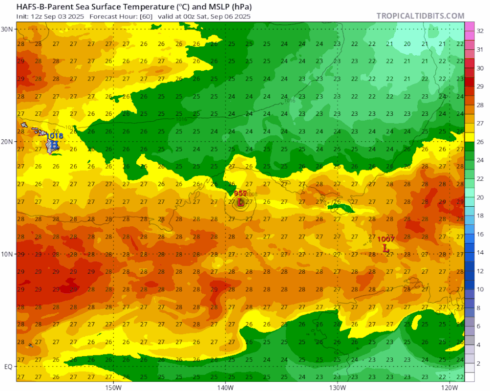
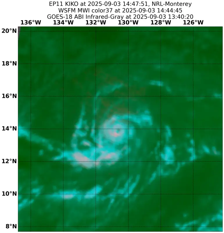
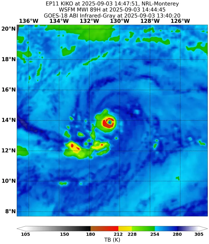
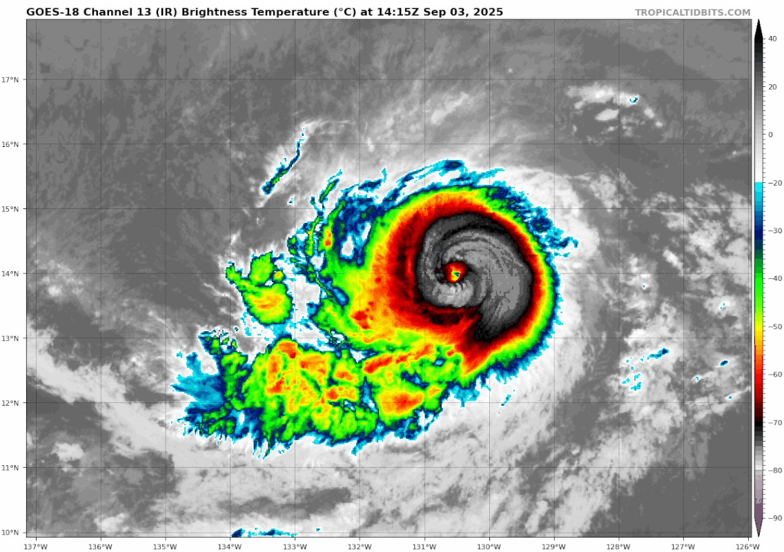
I've mainly been watching the Atlantic recently for obvious reasons, but I figured why not check in on the EPAC? And wow, I was in for a surprise.

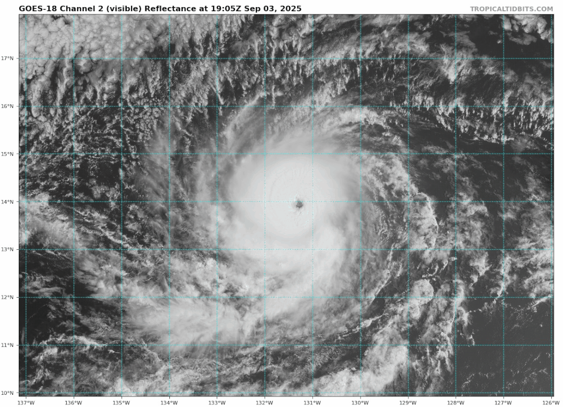
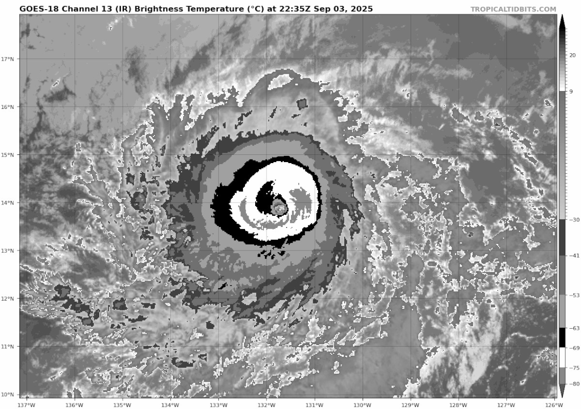
A solid Category 4 hurricane heading towards the vicinity of Hawaii and another hurricane about to cause rainfall in the Desert Southwest? That MJO really boosted the EPAC for sure. Kiko really interests me in that it looks somewhat similar to Douglas from 2020 in terms of possible track except stronger. Really hope it drastically weakens before entering the waters around Hawaii, because if it doesn't, then I think there would be a nonzero possibility that the Big Island could be in for some strong winds, surge, and rain.
4 likes   
Unless explicitly stated, all info in my posts is based on my own opinions and observations. Tropical storms and hurricanes can be extremely dangerous. Do not think you can beat Mother Nature. Refer to an accredited weather research agency or meteorologist if you need to make serious decisions regarding an approaching storm.

User avatar
Kingarabian
S2K Supporter
S2K Supporter
Posts: 16174
Joined: Sat Aug 08, 2009 3:06 am
Location: Honolulu, Hawaii

Re: EPAC: KIKO - Hurricane - Discussion

#139 Postby Kingarabian » Wed Sep 03, 2025 8:06 pm

cycloneye wrote:
EP, 11, 2025090400, , BEST, 0, 138N, 1319W, 125, 944, HU

Should be 130kts unless TAFB came in with a 6.0
0 likes   
RIP Kobe Bryant

Sciencerocks
Category 5
Category 5
Posts: 9367
Age: 39
Joined: Thu Jul 06, 2017 1:51 am

Re: EPAC: KIKO - Hurricane - Discussion

#140 Postby Sciencerocks » Wed Sep 03, 2025 8:23 pm

Image
1 likes   


Return to “Active Storms/Invests - Atlantic/EastPAC/CentralPAC/MED”

Who is online

Users browsing this forum: Google [Bot] and 82 guests