EPAC: KIKO - Remnants - Dscussion
Moderator: S2k Moderators
-
Kingarabian

- S2K Supporter

- Posts: 16379
- Joined: Sat Aug 08, 2009 3:06 am
- Location: Honolulu, Hawaii
Re: EPAC: KIKO - Hurricane - Discussion
Its had a southerly component the past 3-4 hours. Pumping the ridge
0 likes
RIP Kobe Bryant

Re: EPAC: KIKO - Hurricane - Discussion
Is it going through an Eyewall replacement cycle, or is the tilt just obscuring the eye?
0 likes
-
Kingarabian
- S2K Supporter
- Posts: 16379
- Joined: Sat Aug 08, 2009 3:06 am
- Location: Honolulu, Hawaii
Re: EPAC: KIKO - Hurricane - Discussion
Fancy1002 wrote:Is it going through an Eyewall replacement cycle, or is the tilt just obscuring the eye?
Looks like an EWRC is starting.
0 likes
RIP Kobe Bryant
-
cycloneye

- Admin

- Posts: 149730
- Age: 69
- Joined: Thu Oct 10, 2002 10:54 am
- Location: San Juan, Puerto Rico
Re: EPAC: KIKO - Hurricane - Discussion
Hurricane Kiko Discussion Number 16
NWS National Hurricane Center Miami FL EP112025
500 PM HST Wed Sep 03 2025
Kiko remains a powerful category 4 hurricane, with satellite images
showing a well-defined eye surrounded by a very cold ring of deep
convection with cloud top temperatures of -70 to -85C. The most
recent subjective Dvorak current intensity estimates from TAFB and
SAB were 6.0/115 kt and 6.5/127 kt respectively, while the objective
estimates from UW-CIMSS have ranged between 119 and 132 kt during
the past several hours. Based on a blend of these data, the initial
intensity has been raised to 125 kt for this advisory.
Kiko is moving just south of due west, or 265 degrees, at 8 kt.
This general westward motion is expected to continue through
Thursday night, as the cyclone is steered by a building subtropical
ridge to its north and northwest. A turn toward the west-northwest
is forecast on Friday as an upper-level trough north of Hawaii
begins to erode the western portion of the subtropical ridge, with
this general motion then continuing through the weekend with a
gradual increase in forward speed. There remains some along-track
and cross track spread among the global models, although the spread
has decreased considerably during the past 24 hours. The official
track forecast remains in good agreement with a blend of the latest
multi-model consensus aids and is nearly on top of, but slightly
slower than, the previous forecast track.
Kiko will remain over warm waters of 27–28C and influenced by mostly
light vertical wind shear through around 60 to 72 hours. The
surrounding environmental mid-level moisture will remain drier than
optimal, hovering between 50 and 60 percent during the next couple
of days, before dropping below 50 percent by day 3. Despite the
somewhat dry mid-level airmass, the light vertical wind shear and
warm sea surface temperatures should maintain Kiko as a major
hurricane through day 3. There will likely be some fluctuations in
strength during the next several days with the potential for eyewall
replacement cycles during this time. By days 4 and 5, the cyclone
will begin moving over cooler water with gradually increasing
westerly vertical wind shear, and mid-level moisture plummeting
below 40 percent. These factors should lead to steady and
eventually rapid weakening of Kiko as the cyclone approaches the
Hawaiian Islands from the east. Kiko will be influenced by
environmental factors that can lead to the development of annular
characteristics along its approach, which can slow the rate of
weakening. As a result, the official intensity forecast remains on
the higher end or slightly above the intensity aids through day 5,
and is very close to the previous advisory.
FORECAST POSITIONS AND MAX WINDS
INIT 04/0300Z 13.8N 132.3W 125 KT 145 MPH
12H 04/1200Z 13.8N 133.4W 125 KT 145 MPH
24H 05/0000Z 13.9N 135.0W 125 KT 145 MPH
36H 05/1200Z 14.1N 136.6W 125 KT 145 MPH
48H 06/0000Z 14.6N 138.1W 120 KT 140 MPH
60H 06/1200Z 15.1N 139.7W 110 KT 125 MPH
72H 07/0000Z 15.7N 141.3W 105 KT 120 MPH
96H 08/0000Z 17.1N 145.1W 90 KT 105 MPH
120H 09/0000Z 18.5N 149.8W 70 KT 80 MPH
$$
Forecaster Jelsema (CPHC)
0 likes
Visit the Caribbean-Central America Weather Thread where you can find at first post web cams,radars
and observations from Caribbean basin members Click Here
and observations from Caribbean basin members Click Here
-
Sciencerocks
- Category 5

- Posts: 10193
- Age: 40
- Joined: Thu Jul 06, 2017 1:51 am

-
cycloneye
- Admin
- Posts: 149730
- Age: 69
- Joined: Thu Oct 10, 2002 10:54 am
- Location: San Juan, Puerto Rico
Re: EPAC: KIKO - Hurricane - Discussion
Hurricane Kiko Discussion Number 17
NWS National Hurricane Center Miami FL EP112025
1100 PM HST Wed Sep 03 2025
The satellite presentation of Kiko has degraded some since the
previous advisory, with the eye now mostly obscured by a central
dense overcast with cloud top temperatures of -70 to -80C. Given
the favorable environment that the cyclone is traversing, it is
likely that Kiko is undergoing an eyewall replacement cycle at the
moment. The most recent subjective Dvorak current intensity
estimates from TAFB and SAB were 6.0/115 kt and 6.5/127 kt
respectively, while the objective estimates from UW-CIMSS have
ranged between 111 and 132 kt during the past several hours. Based
on a blend of these data, the initial intensity has been held at 125
kt for this advisory, and Kiko remains a very powerful category 4
hurricane.
Kiko is moving just south of due west, or 265 degrees, at 7 kt.
This general westward motion is expected to continue through
Thursday, as the cyclone is steered by a building subtropical ridge
to its north and northwest. A turn toward the west-northwest is
forecast by Friday as an upper-level trough north of Hawaii begins
to erode the western portion of the subtropical ridge, with this
general motion then continuing over the weekend and into early next
week, along with a gradual increase in forward speed. There remains
some along-track and cross track spread among the global models,
although the spread has decreased considerably during the past 24
hours. A very slight northward adjustment has been made to the
official track forecast, which remains in good agreement with a
blend of the latest multi-model consensus aids.
Kiko will remain over warm waters of 27–28C and influenced by mostly
light vertical wind shear through around 60 hours. The surrounding
environmental mid-level moisture will remain drier than optimal,
hovering between 50 and 60 percent during the next couple of days,
before dropping below 50 percent by 60 hours. Despite the somewhat
dry mid-level airmass, the light vertical wind shear and warm sea
surface temperatures should maintain Kiko as a major hurricane
through day 3. There will likely be some fluctuations in strength
during the next several days with the potential for eyewall
replacement cycles during this time. By days 4 and 5, the cyclone
will begin moving over cooler water with gradually increasing
westerly vertical wind shear, and mid-level moisture plummeting
below 40 percent. These factors should lead to steady and
eventually rapid weakening of Kiko as the cyclone approaches the
Hawaiian Islands from the east-southeast. Kiko will be influenced
by environmental factors that can lead to the development of annular
characteristics during the next few days along its approach, which
can slow the rate of weakening. As a result, the official intensity
forecast remains on the higher end or slightly above the intensity
aids through day 5, and is very similar to the previous advisory.
FORECAST POSITIONS AND MAX WINDS
INIT 04/0900Z 13.7N 133.0W 125 KT 145 MPH
12H 04/1800Z 13.9N 134.1W 120 KT 140 MPH
24H 05/0600Z 14.1N 135.8W 120 KT 140 MPH
36H 05/1800Z 14.5N 137.4W 120 KT 140 MPH
48H 06/0600Z 15.0N 139.1W 115 KT 130 MPH
60H 06/1800Z 15.7N 140.9W 110 KT 125 MPH
72H 07/0600Z 16.4N 142.7W 105 KT 120 MPH
96H 08/0600Z 17.8N 146.9W 95 KT 110 MPH
120H 09/0600Z 19.2N 151.5W 70 KT 80 MPH
$$
Forecaster Jelsema (CPHC)
0 likes
Visit the Caribbean-Central America Weather Thread where you can find at first post web cams,radars
and observations from Caribbean basin members Click Here
and observations from Caribbean basin members Click Here
-
Yellow Evan

- Professional-Met

- Posts: 16257
- Age: 27
- Joined: Fri Jul 15, 2011 12:48 pm
- Location: Henderson, Nevada/Honolulu, HI
- Contact:
Re: EPAC: KIKO - Hurricane - Discussion
IR evolution is very much one of shear not an ERC with how much convection is struggling to wrap.
1 likes
-
Kingarabian
- S2K Supporter
- Posts: 16379
- Joined: Sat Aug 08, 2009 3:06 am
- Location: Honolulu, Hawaii
Re: EPAC: KIKO - Hurricane - Discussion
Yellow Evan wrote:IR evolution is very much one of shear not an ERC with how much convection is struggling to wrap.
Looks lik its now recovering. Also looks like annular transition has begun.
CIMSS shows deep layer and mid layer shear very favorable.
0 likes
RIP Kobe Bryant
-
cycloneye
- Admin
- Posts: 149730
- Age: 69
- Joined: Thu Oct 10, 2002 10:54 am
- Location: San Juan, Puerto Rico
Re: EPAC: KIKO - Hurricane - Discussion
EP, 11, 2025090412, , BEST, 0, 138N, 1333W, 115, 951, HU
0 likes
Visit the Caribbean-Central America Weather Thread where you can find at first post web cams,radars
and observations from Caribbean basin members Click Here
and observations from Caribbean basin members Click Here
-
Kingarabian
- S2K Supporter
- Posts: 16379
- Joined: Sat Aug 08, 2009 3:06 am
- Location: Honolulu, Hawaii
Re: EPAC: KIKO - Hurricane - Discussion
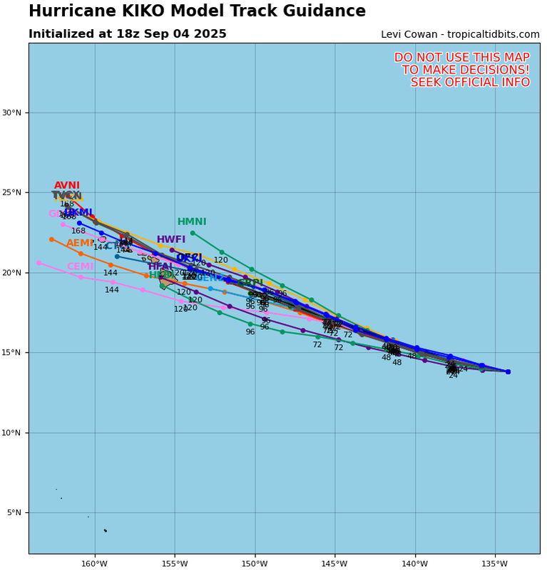
Today's Euro runs have shifted north of Hawaii.
EPS still has half the ensembles pointing at Hawaii.
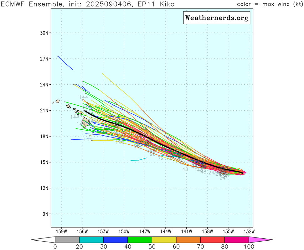
GEFS further south.
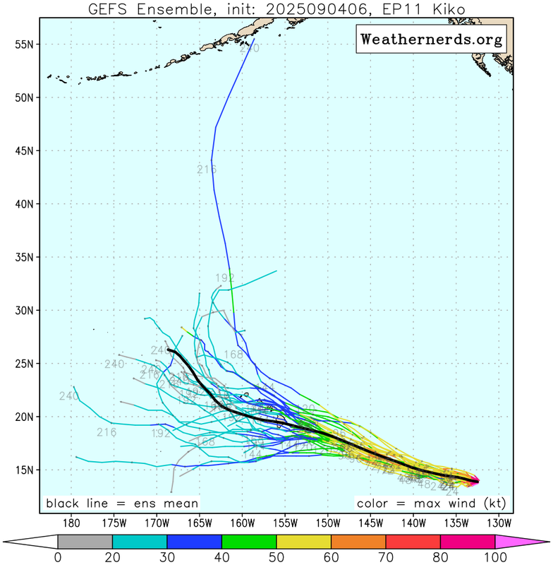
EPS still has half the ensembles pointing at Hawaii.
GEFS further south.
0 likes
RIP Kobe Bryant

Re: EPAC: KIKO - Hurricane - Discussion
0 likes
TC naming lists: retirements and intensity
Most aggressive Advisory #1's in North Atlantic (cr. kevin for starting the list)
Most aggressive Advisory #1's in North Atlantic (cr. kevin for starting the list)
-
TomballEd
- Category 5
- Posts: 1322
- Age: 62
- Joined: Wed Aug 16, 2023 4:52 pm
- Location: Spring/Klein area, not Tomball
Re: EPAC: KIKO - Hurricane - Discussion
Do the WC-130J's ever forward deploy to Hawaii to monitor threats? A G-IV mission would be especially useful a couple of days from now. I suspect G-IVs have longer range. Not sure if the stated 2000 mile range of the Super Hercules is sufficient to reach Hickham. G-IVs have double the range.
1 likes
-
Kingarabian
- S2K Supporter
- Posts: 16379
- Joined: Sat Aug 08, 2009 3:06 am
- Location: Honolulu, Hawaii
Re: EPAC: KIKO - Hurricane - Discussion
TomballEd wrote:Do the WC-130J's ever forward deploy to Hawaii to monitor threats? A G-IV mission would be especially useful a couple of days from now. I suspect G-IVs have longer range. Not sure if the stated 2000 mile range of the Super Hercules is sufficient to reach Hickham. G-IVs have double the range.
Yes they do. As long as modeling continues this way, they will likely run missions starting this weekend. G-IV's do come out as well but sometimes the WC-130J's help with the atmosphere sampling.
Last edited by Kingarabian on Thu Sep 04, 2025 10:45 am, edited 1 time in total.
0 likes
RIP Kobe Bryant
-
Kingarabian
- S2K Supporter
- Posts: 16379
- Joined: Sat Aug 08, 2009 3:06 am
- Location: Honolulu, Hawaii
Re: EPAC: KIKO - Hurricane - Discussion
Excellent NHC discussion.
727
WTPZ41 KNHC 041458
TCDEP1
Hurricane Kiko Discussion Number 18
NWS National Hurricane Center Miami FL EP112025
Issued by the NWS Weather Prediction Center College Park MD
500 AM HST Thu Sep 04 2025
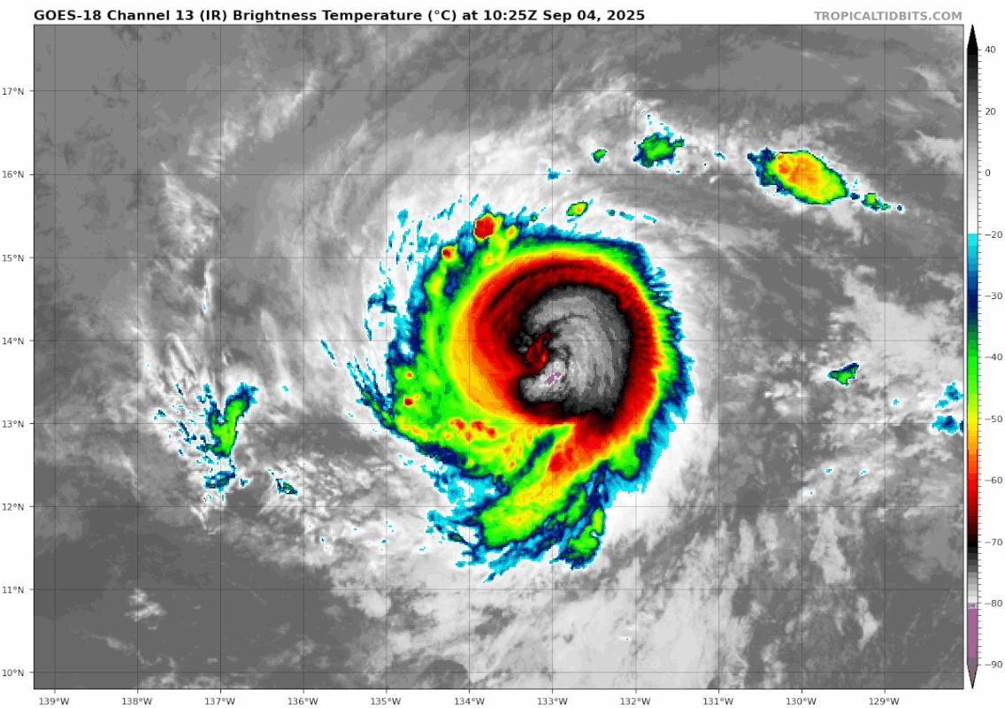
The satellite presentation of Kiko continues with a weaker depiction
compared to yesterday evening, but beginning to see some
stabilization in the core with a little more convective wrap within
the southern flank of the eyewall. IR satellite and accompanying
Dvorak imagery indicates a likely eyewall replacement cycle (EWRC)
occurring over the past 12 hours, leading to the marginal
degradation of the storms presentation. The most recent subjective
Dvorak current intensity estimates from TAFB and SAB were each
6.0/115 kt, while the objective estimates from UW-CIMSS have ranged
between 108 and 127 kt during the past several hours. Based on the
latest data from both the subjective and objective analysis, the
initial intensity has been adjusted to 115 kt for this advisory,
however Kiko still remains a very powerful category 4 hurricane.
With Kiko's EWRC anticipated to be completed later today, the
expectation is for Kiko's inner-core to stabilize. Given the
favorable environment that the cyclone is traversing, the latest
intensity forecast shows the hurricane re-intensifying after the
EWRC completes in the short-term. Thereafter, the current
environment is quite favorable for Kiko to attempt to develop
annular characteristics, which often allows a hurricane to remain
stronger and closer to the maximum potential intensity (MPI) than
what the more marginal thermodynamics would typically allow. The
short-term intensity forecast is actually above the vast majority of
the interpolated intensity aids, which are somewhat influenced by
the lower initial intensity. However, the latest raw output from
both HAFS-A/B show Kiko maintaining category 4 intensity for at
least the next 48 hours, and that is what will be reflected in this
latest forecast. After 72 hours, Kiko's environment becomes less
favorable, with increasing southwesterly vertical wind shear, and
sea-surface temperatures decreasing below 26 C. Thus, more
pronounced weakening is expected from days 3-5, with the intensity
forecast falling back in line with the majority of the consensus
intensity aids.
Kiko is moving due west, or 270 degrees, at 8 kt. This general
westward motion is expected to continue through the day due to a
building subtropical ridge to its north and northwest. Afterwards,
this ridge begins to erode on its western side due to an upper-level
trough digging in to the north of Hawaii. Thus, Kiko should begin to
gain more latitude after the next 24 hours, and maintain a more
west-northwestward heading through the remainder of the forecast
period. The track guidance remains very tightly clustered in the
short-term, though spread in the various consensus guidance aids
increases to above climatology by the end of the forecast period.
Ultimately, the latest NHC track forecast is quite similar to the
prior one, just a little faster due to the latest guidance updates.
Key Messages:
1. Kiko is forecast to approach the Hawaiian Islands during the
early to the middle portion of next week. The risk of direct impacts
from wind and rainfall is increasing. However, it is too soon to
determine the exact location or magnitude of these impacts, and
interests there should continue to monitor the progress of this
storm.
FORECAST POSITIONS AND MAX WINDS
INIT 04/1500Z 13.8N 133.7W 115 KT 130 MPH
12H 05/0000Z 13.9N 134.9W 120 KT 140 MPH
24H 05/1200Z 14.3N 136.6W 125 KT 145 MPH
36H 06/0000Z 14.7N 138.3W 120 KT 140 MPH
48H 06/1200Z 15.3N 140.1W 115 KT 130 MPH
60H 07/0000Z 16.0N 142.0W 110 KT 125 MPH
72H 07/1200Z 16.7N 144.0W 105 KT 120 MPH
96H 08/1200Z 18.3N 148.1W 85 KT 100 MPH
120H 09/1200Z 19.9N 152.8W 60 KT 70 MPH
$$
Forecaster Kleebauer/Papin
WTPZ41 KNHC 041458
TCDEP1
Hurricane Kiko Discussion Number 18
NWS National Hurricane Center Miami FL EP112025
Issued by the NWS Weather Prediction Center College Park MD
500 AM HST Thu Sep 04 2025
The satellite presentation of Kiko continues with a weaker depiction
compared to yesterday evening, but beginning to see some
stabilization in the core with a little more convective wrap within
the southern flank of the eyewall. IR satellite and accompanying
Dvorak imagery indicates a likely eyewall replacement cycle (EWRC)
occurring over the past 12 hours, leading to the marginal
degradation of the storms presentation. The most recent subjective
Dvorak current intensity estimates from TAFB and SAB were each
6.0/115 kt, while the objective estimates from UW-CIMSS have ranged
between 108 and 127 kt during the past several hours. Based on the
latest data from both the subjective and objective analysis, the
initial intensity has been adjusted to 115 kt for this advisory,
however Kiko still remains a very powerful category 4 hurricane.
With Kiko's EWRC anticipated to be completed later today, the
expectation is for Kiko's inner-core to stabilize. Given the
favorable environment that the cyclone is traversing, the latest
intensity forecast shows the hurricane re-intensifying after the
EWRC completes in the short-term. Thereafter, the current
environment is quite favorable for Kiko to attempt to develop
annular characteristics, which often allows a hurricane to remain
stronger and closer to the maximum potential intensity (MPI) than
what the more marginal thermodynamics would typically allow. The
short-term intensity forecast is actually above the vast majority of
the interpolated intensity aids, which are somewhat influenced by
the lower initial intensity. However, the latest raw output from
both HAFS-A/B show Kiko maintaining category 4 intensity for at
least the next 48 hours, and that is what will be reflected in this
latest forecast. After 72 hours, Kiko's environment becomes less
favorable, with increasing southwesterly vertical wind shear, and
sea-surface temperatures decreasing below 26 C. Thus, more
pronounced weakening is expected from days 3-5, with the intensity
forecast falling back in line with the majority of the consensus
intensity aids.
Kiko is moving due west, or 270 degrees, at 8 kt. This general
westward motion is expected to continue through the day due to a
building subtropical ridge to its north and northwest. Afterwards,
this ridge begins to erode on its western side due to an upper-level
trough digging in to the north of Hawaii. Thus, Kiko should begin to
gain more latitude after the next 24 hours, and maintain a more
west-northwestward heading through the remainder of the forecast
period. The track guidance remains very tightly clustered in the
short-term, though spread in the various consensus guidance aids
increases to above climatology by the end of the forecast period.
Ultimately, the latest NHC track forecast is quite similar to the
prior one, just a little faster due to the latest guidance updates.
Key Messages:
1. Kiko is forecast to approach the Hawaiian Islands during the
early to the middle portion of next week. The risk of direct impacts
from wind and rainfall is increasing. However, it is too soon to
determine the exact location or magnitude of these impacts, and
interests there should continue to monitor the progress of this
storm.
FORECAST POSITIONS AND MAX WINDS
INIT 04/1500Z 13.8N 133.7W 115 KT 130 MPH
12H 05/0000Z 13.9N 134.9W 120 KT 140 MPH
24H 05/1200Z 14.3N 136.6W 125 KT 145 MPH
36H 06/0000Z 14.7N 138.3W 120 KT 140 MPH
48H 06/1200Z 15.3N 140.1W 115 KT 130 MPH
60H 07/0000Z 16.0N 142.0W 110 KT 125 MPH
72H 07/1200Z 16.7N 144.0W 105 KT 120 MPH
96H 08/1200Z 18.3N 148.1W 85 KT 100 MPH
120H 09/1200Z 19.9N 152.8W 60 KT 70 MPH
$$
Forecaster Kleebauer/Papin
0 likes
RIP Kobe Bryant


Re: EPAC: KIKO - Hurricane - Discussion
Kingarabian wrote:TomballEd wrote:Do the WC-130J's ever forward deploy to Hawaii to monitor threats? A G-IV mission would be especially useful a couple of days from now. I suspect G-IVs have longer range. Not sure if the stated 2000 mile range of the Super Hercules is sufficient to reach Hickham. G-IVs have double the range.
Yes they do. As long as modeling continues this way, they will likely run missions starting this weekend. G-IV's do come out as well but sometimes the WC-130J's help with the atmosphere sampling.
According to the TCPOD a recon fix is tentatively scheduled for the Sunday at 6z, nothing about a synoptic surveillance mission as of yet.
0 likes
-
Kingarabian
- S2K Supporter
- Posts: 16379
- Joined: Sat Aug 08, 2009 3:06 am
- Location: Honolulu, Hawaii
Re: EPAC: KIKO - Hurricane - Discussion
Today's runs through 12z show potential for the ridge to be eroded quite more than the past forecasts. Results in a track that slips NE of the Hawaiian Islands. Still got solutions from the UKMET/GFS/HAFSA/B/ICON and still a significant amount of ensembles from all the models that still show one or more of the islands getting at least some impacts or this slpping south of Hawaii.
Last edited by Kingarabian on Thu Sep 04, 2025 3:05 pm, edited 1 time in total.
0 likes
RIP Kobe Bryant
-
Kingarabian
- S2K Supporter
- Posts: 16379
- Joined: Sat Aug 08, 2009 3:06 am
- Location: Honolulu, Hawaii
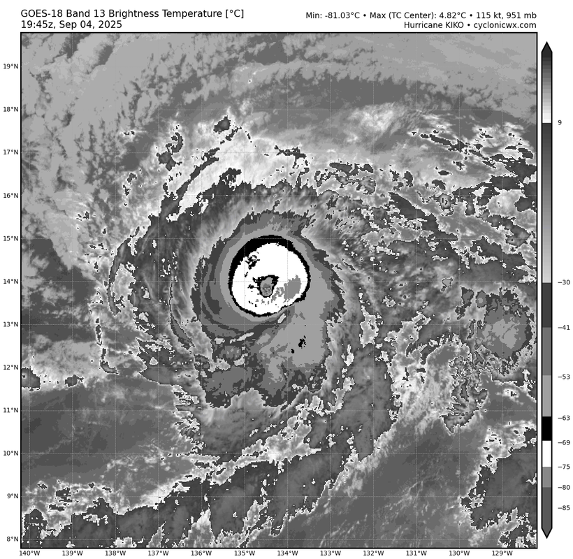
Re: EPAC: KIKO - Hurricane - Discussion
Past few frames showing a solid T6.0. OW eye embedded in B, surrounded by W. I would up the intensity back up to 115kts.
0 likes
RIP Kobe Bryant
Who is online
Users browsing this forum: No registered users and 35 guests