
Keep in mind that the FL landfall is 300 hours out. Both the track and intensity can and will change.
The most important takeaway should be that land masses in the Caribbean islands and along the entire CONUS east coast are potentially at risk.
ATL: Ex-INVEST 91L - Models
Moderator: S2k Moderators
Re: ATL: INVEST 91L - Models
4 likes
TC naming lists: retirements and intensity
Most aggressive Advisory #1's in North Atlantic (cr. kevin for starting the list)
Most aggressive Advisory #1's in North Atlantic (cr. kevin for starting the list)
Re: ATL: INVEST 91L - Models
LAF92 wrote:It feels like the GFS operational and ensembles are completely lost.
There's a cutoff low involved, even the NHC will probably be lost or highly challenged. This is going to be one of those head bashers for both track and intensity if it's anywhere close to this. The ensembles probably won't narrow even after a week. The 12z GFS is basically an east coast menace from the keys all the way up to New England and Canada.
3 likes
Re: ATL: INVEST 91L - Models
Hurricane models are running. No closed circulation yet so intensity and track won't be significant apart from gauging the favourability of the environment.
Once we (if) we get a system out of this I'd be curious to see how the HAFS handles it since it often picks up on things that the lower resolution global models miss.
Once we (if) we get a system out of this I'd be curious to see how the HAFS handles it since it often picks up on things that the lower resolution global models miss.
Last edited by Pelicane on Thu Sep 04, 2025 12:27 pm, edited 1 time in total.
1 likes
Re: ATL: INVEST 91L - Models
BobHarlem wrote:LAF92 wrote:It feels like the GFS operational and ensembles are completely lost.
There's a cutoff low involved, even the NHC will probably be lost or highly challenged. This is going to be one of those head bashers for both track and intensity if it's anywhere close to this. The ensembles probably won't narrow even after a week. The 12z GFS is basically an east coast menace from the keys all the way up to New England and Canada.
So you think this system getting into the gulf is unlikely?
0 likes
Re: ATL: INVEST 91L - Models
Long term uncertainty with this one I think is 10/10.
As it is, we already know that 7-15 days out is fantasy land, but given all the unknowns and anomalous features that are currently being modeled, for now just figure the whole basin is in play
As it is, we already know that 7-15 days out is fantasy land, but given all the unknowns and anomalous features that are currently being modeled, for now just figure the whole basin is in play
0 likes

Re: ATL: INVEST 91L - Models
12z Euro running. Also shows the second vortex to the SW (less pronounced than GFS) at +72/78 hours which keeps it as a weak TS for now and keeps the storm south, 12N/44W at +78h.
0 likes
Re: ATL: INVEST 91L - Models
LAF92 wrote:BobHarlem wrote:LAF92 wrote:It feels like the GFS operational and ensembles are completely lost.
There's a cutoff low involved, even the NHC will probably be lost or highly challenged. This is going to be one of those head bashers for both track and intensity if it's anywhere close to this. The ensembles probably won't narrow even after a week. The 12z GFS is basically an east coast menace from the keys all the way up to New England and Canada.
So you think this system getting into the gulf is unlikely?
I would say it is unlikely right now but not impossible. The 12Z GFS was pretty close to getting into the gulf. If ridging builds in further west or if that cutoff ULL over the East Central gulf gets out of the picture faster then it is possible.
1 likes
-
jlauderdal
- S2K Supporter

- Posts: 7240
- Joined: Wed May 19, 2004 5:46 am
- Location: NE Fort Lauderdale
- Contact:
Re: ATL: INVEST 91L - Models
LAF92 wrote:It feels like the GFS operational and ensembles are completely lost.
They see things differently; chances are very good that one of them has the right idea, recurve chances down from yesterday, cant say anything else at this point. Folks, we have members Luis, msbee, Abajan(sp) that are first up on these systems, please be respectful when calling fish and all that and yes, wind is a problem, flooding is a huge problem for them due to the terrain so just beacuse its a td or even less or something more intense, never forget the hydrology issues they face that most of us dont see. 5 inches of rain for jlauderdal is very different for the islands, etc.
Cheers
5 likes
Re: ATL: INVEST 91L - Models
12z euro is a lot faster than the 12z gfs, and the 0z euro, and the 12z is slightly to the right of the 0z euro. Much weaker also, as in it never really develops it. Models may be struggling with the small size and lack of moisture (aka dry air may be an issue with this one). Google still goes poof in the Caribbean.
Last edited by BobHarlem on Thu Sep 04, 2025 1:01 pm, edited 5 times in total.
0 likes
Re: ATL: INVEST 91L - Models
12Z:
-Euro: TS that later weakens to a weak low as it crosses the Lesser Antilles and then goes through N Caribbean disorganized/very weak
-UKMET: no TC again/low too weak to be classified a TD
-Euro: TS that later weakens to a weak low as it crosses the Lesser Antilles and then goes through N Caribbean disorganized/very weak
-UKMET: no TC again/low too weak to be classified a TD
0 likes
Personal Forecast Disclaimer:
The posts in this forum are NOT official forecasts and should not be used as such. They are just the opinion of the poster and may or may not be backed by sound meteorological data. They are NOT endorsed by any professional institution or storm2k.org. For official information, please refer to the NHC and NWS products.
The posts in this forum are NOT official forecasts and should not be used as such. They are just the opinion of the poster and may or may not be backed by sound meteorological data. They are NOT endorsed by any professional institution or storm2k.org. For official information, please refer to the NHC and NWS products.
Re: ATL: INVEST 91L - Models
LarryWx wrote:12Z:
-Euro: TS that later weakens to a weak low as it crosses the Lesser Antilles and then goes through N Caribbean disorganized/very weak
-UKMET: no TC again/low too weak to be classified a TD
I find it interesting as well that the Euro AI model has consistently shown no development at all
1 likes
-
TampaWxLurker
- Tropical Storm

- Posts: 196
- Joined: Thu Aug 01, 2024 8:20 am
Re: ATL: INVEST 91L - Models
Seems like the models are picking up on unfavorable background conditions re: shear & dry air. Let's see if it sticks in the next few runs.
0 likes
Re: ATL: INVEST 91L - Models
sma10 wrote:LarryWx wrote:12Z:
-Euro: TS that later weakens to a weak low as it crosses the Lesser Antilles and then goes through N Caribbean disorganized/very weak
-UKMET: no TC again/low too weak to be classified a TD
I find it interesting as well that the Euro AI model has consistently shown no development at all
NHC just upped development odds to 90% so I think no development at all is unlikely but there is a world where all we get out of this is a weak TS or even just a TD that gets shredded by shear.
2 likes


Re: ATL: INVEST 91L - Models
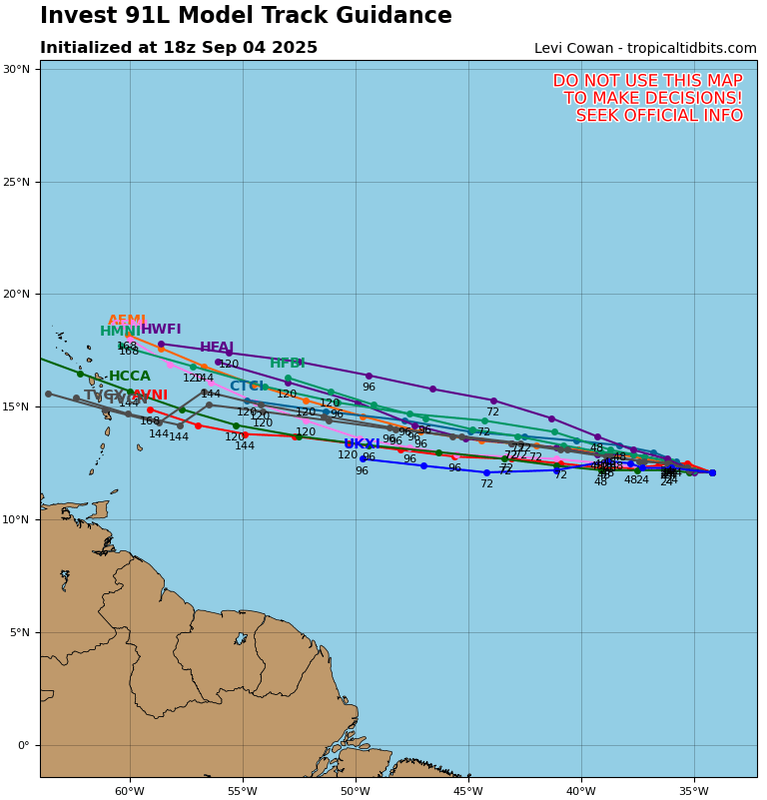
It's surprising how little model consensus there is at the moment. The ensembles are every where from East of Bermuda all the way to the Central Gulf. The operationals are making large swings even in the short term. Hopefullly things settle down once the circulation begins to consolidate.
3 likes
-
WeatherBoy2000
- Category 1

- Posts: 463
- Joined: Mon Apr 10, 2023 9:29 am
Re: ATL: INVEST 91L - Models
TampaWxLurker wrote:Seems like the models are picking up on unfavorable background conditions re: shear & dry air. Let's see if it sticks in the next few runs.
We're going to need to see more consistent model runs before this can be said confidently, the euro has bounced back and forth between major hurricane and just TS for days now.
3 likes
-
TomballEd
- Category 5

- Posts: 1322
- Age: 62
- Joined: Wed Aug 16, 2023 4:52 pm
- Location: Spring/Klein area, not Tomball
Re: ATL: INVEST 91L - Models
It'll have a hard time becoming a large storm because it will be surrounded by drier air.

3 likes
Re: ATL: INVEST 91L - Models
The 12Z EPS has one member from 91L hit FL, another headed toward the Gulf, and a couple of others not far from hitting the NE US as they recurve. But overall, that’s still pretty quiet for CONUS. Interestingly, there’s more Conus hits from other systems, mainly homegrown stuff.
0 likes
Personal Forecast Disclaimer:
The posts in this forum are NOT official forecasts and should not be used as such. They are just the opinion of the poster and may or may not be backed by sound meteorological data. They are NOT endorsed by any professional institution or storm2k.org. For official information, please refer to the NHC and NWS products.
The posts in this forum are NOT official forecasts and should not be used as such. They are just the opinion of the poster and may or may not be backed by sound meteorological data. They are NOT endorsed by any professional institution or storm2k.org. For official information, please refer to the NHC and NWS products.

-
tolakram
- Admin

- Posts: 20186
- Age: 62
- Joined: Sun Aug 27, 2006 8:23 pm
- Location: Florence, KY (name is Mark)
Re: ATL: INVEST 91L - Models
sma10 wrote:LarryWx wrote:12Z:
-Euro: TS that later weakens to a weak low as it crosses the Lesser Antilles and then goes through N Caribbean disorganized/very weak
-UKMET: no TC again/low too weak to be classified a TD
I find it interesting as well that the Euro AI model has consistently shown no development at all
What is the artificial intelligence that this model is using, just past storms? Unless I see evidence otherwise the AI models are just climatological likelihoods with maybe some recency bias throw in for good measure.
Deep learning: AIFS is a deep learning system trained on historical weather data.
Data sources: It uses the same observational initial conditions as ECMWF's traditional physics-based model. This includes data from satellites, aircraft, buoys, and other measurement stations.
High performance: AIFS offers significant advantages in speed and energy efficiency, allowing it to generate forecasts much faster and with a lower computational footprint than traditional methods.
source: https://www.ecmwf.int/en/about/media-centre/news/2025/ecmwfs-ai-forecasts-become-operational#:~:text=The%20AIFS%20uses%20the%20same,more%20than%20thirty%20years%20ago.
1 likes
M a r k
- - - - -
Join us in chat: Storm2K Chatroom Invite. Android and IOS apps also available.
The posts in this forum are NOT official forecasts and should not be used as such. Posts are NOT endorsed by any professional institution or STORM2K.org. For official information and forecasts, please refer to NHC and NWS products.
Re: ATL: INVEST 91L - Models
The first runs of hurricane models are generally unenthusiastic with intensity. They generally show an initial peak in the TS-Cat 1 range at 45-50W, with the strongest, HWRF, showing a 984 mb Cat 2. Some weakening back to a TS occurs further west. While HAFS-B intensifies again at the end of the run (126 hrs), that's not clear on other models. HMON and HWRF-A (which is based on the former) don't show a hurricane at all throughout the run.
Note that (a) further intensification is possible beyond the end of the runs, and (b) they can easily change in future runs.
Note that (a) further intensification is possible beyond the end of the runs, and (b) they can easily change in future runs.
0 likes
TC naming lists: retirements and intensity
Most aggressive Advisory #1's in North Atlantic (cr. kevin for starting the list)
Most aggressive Advisory #1's in North Atlantic (cr. kevin for starting the list)
Who is online
Users browsing this forum: No registered users and 75 guests