Area of disturbed weather east of the Windward Islands

This is the general tropical discussion area. Anyone can take their shot at predicting a storms path.

Moderator: S2k Moderators

Forum rules

The posts in this forum are NOT official forecasts and should not be used as such. They are just the opinion of the poster and may or may not be backed by sound meteorological data. They are NOT endorsed by any professional institution or STORM2K. For official information, please refer to products from the National Hurricane Center and National Weather Service.

Help Support Storm2K
Message
Author
User avatar
Teban54
Category 5
Category 5
Posts: 3299
Joined: Sat May 19, 2018 1:19 pm

Area of disturbed weather east of the Windward Islands

#1 Postby Teban54 » Thu Sep 04, 2025 3:53 pm

There have been a few comments in the Global Model Runs thread about this area of convection embedded in the monsoon trough WSW of 91L. An earlier ASCAT-C shows a closed circulation, and a new hot tower just fired in the last few frames.

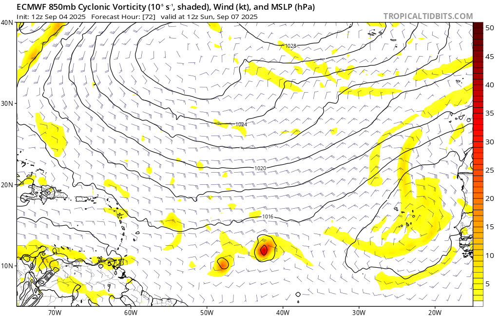
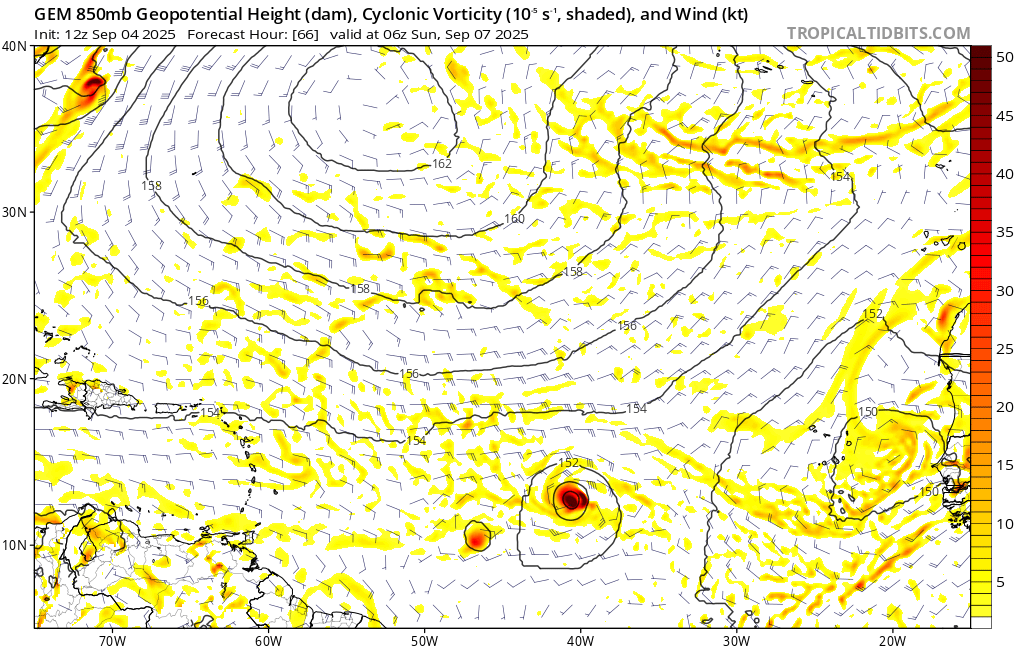
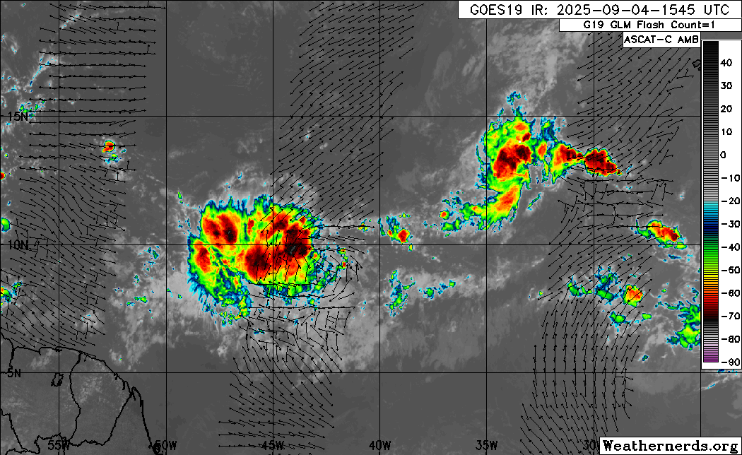
In this loop, this area is to the west and 91L is to the east.

Image

12z global models are acknowledging this feature for the first time, and show some consolidation of the vorticity in the next 3-4 days as the monsoon trough breaks down. 12z GFS still shows 91L as the dominant feature, doing a Fujiwhara with the vort at 45W and absorbing the latter.

Image

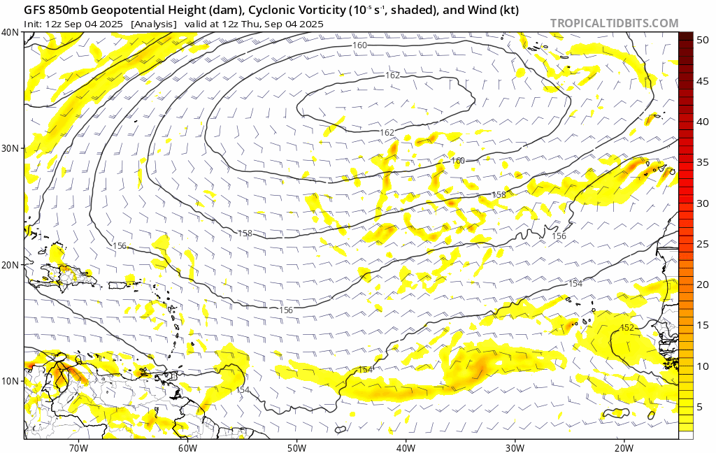
This is also the case in 12z ECMWF and CMC. Notably, none of the three models showed such a distinctive vortmax at 45W at this hour, in their 0z and 6z runs.

Image

Image
1 likes   

User avatar
Jr0d
S2K Supporter
S2K Supporter
Posts: 1438
Joined: Tue Aug 27, 2019 10:52 am
Location: Cayo Hueso

Re: Area of disturbed weather east of the Windward Islands

#2 Postby Jr0d » Thu Sep 04, 2025 4:21 pm

I do think this feature will need to be watched even it does not develop anytime soon. The disturbance potentially wil be in the West Carib then the GoM late next week where there is some indication it might find favorable conditions.

Currently here in the lower Keys we have had 3 days of rain thanks to a stallled front. The only good thing about this is it will help cool off the excessively hot waters. Regardless the water will be hot in the Gulf all month.
0 likes   

User avatar
Teban54
Category 5
Category 5
Posts: 3299
Joined: Sat May 19, 2018 1:19 pm

Re: Area of disturbed weather east of the Windward Islands

#3 Postby Teban54 » Thu Sep 04, 2025 4:32 pm

From the Global Model Runs thread:

zzzh wrote::uarrow: Monsoon trough break downs are tricky to forecast. I remember no models showed Franklin'23 developing until about 2~3 days before it reached TS intensity. It should be noted that Franklin was also in the western edge of the monsoon trough.


I went back and dug through the 2023 threads. Here's a timeline for Franklin 2023:

  • Around August 14-15, models were mostly enthusiastic about the two waves that eventually became Emily (Eastern Atlantic) and Gert (Central Atlantic), east of pre-Franklin.
  • The first surviving hint of a vortmax for the pre-Franklin wave seemed to be the 0z and 6z GFS runs on August 16. Both show a weak vort east of the Lesser Antilles on 12z 8/19. But 12z 8/16 ECMWF still showed the pre-Franklin wave being stretched out in the Eastern Caribbean in favor of Gert.
  • August 17 was when most models started to really favor pre-Franklin over pre-Emily and pre-Gert. 12z ECMWF and 18z EPS both showed support; the former even had Franklin cannibalizing Gert and preventing the latter from genesis.
  • The wave became a 10/20 AOI at 0z August 18, and Invest 90L at 6z August 19.
  • TD 8 formed at 6z August 20 in Eastern Caribbean, 54 hours after it first appeared as a 10/20 AOI. It strengthened into TS Franklin after another six hours, and did so six hours earlier than Gert to its east.
  • Franklin eventually peaked as a 130 kt Cat 4 in the subtropics days later (even though it was a weak/moderate TS within the Caribbean). Gert, which models initially favored, never strengthened beyond 35 kts in the MDR before dissipation (but regenerated in the subtropics later).
In summary, models only started becoming enthusiastic about Franklin 3-4 days before it formed, with a shift in focus from Gert to Franklin during that time frame (even though both did become TCs).
1 likes   

Stratton23
Category 5
Category 5
Posts: 2709
Joined: Fri Jul 21, 2023 10:59 pm
Location: Katy, Tx

Re: Area of disturbed weather east of the Windward Islands

#4 Postby Stratton23 » Thu Sep 04, 2025 5:52 pm

Teban54 looks like the 18z GFS tries to take this area of distubed weather into the western gulf and interacts with a frontal boundary, getting some sort of weak system trying to form at day 10 ish
0 likes   


Return to “Talkin' Tropics”

Who is online

Users browsing this forum: AnnularCane, LarryWx, pepecool20 and 175 guests