
EPAC: KIKO - Remnants - Dscussion
Moderator: S2k Moderators
Re: EPAC: KIKO - Hurricane - Discussion
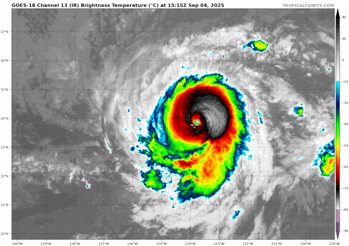
Loop of the recent recovery:
2 likes
TC naming lists: retirements and intensity
Most aggressive Advisory #1's in North Atlantic (cr. kevin for starting the list)
Most aggressive Advisory #1's in North Atlantic (cr. kevin for starting the list)
-
cycloneye

- Admin

- Posts: 149725
- Age: 69
- Joined: Thu Oct 10, 2002 10:54 am
- Location: San Juan, Puerto Rico
Re: EPAC: KIKO - Hurricane - Discussion
Hurricane Kiko Discussion Number 19
NWS National Hurricane Center Miami FL EP112025
Issued by the NWS Weather Prediction Center College Park MD
1100 AM HST Thu Sep 04 2025
Recent IR satellite imagery indicates Kiko's presentation is
improving as the previous eyewall replacement cycle (EWRC) process
is likely in its final stages of concluding, with the eye beginning
to clear out. Latest Dvorak estimates from TAFB and SAB remain at
T6.0/115 kt, with objective intensity estimates only starting to
increase again. Thus, the initial intensity for now will remain 115
knots.
Now that Kiko is completing its EWRC, some reintensification is
possible. The overall environment remains favorable, with
sea-surface temperatures (SST) remaining between 27-28 C with modest
northeasterly shear. Previous forecasts from the interpolated
intensity aids were below the official NHC forecast. However, this
area of the Pacific has historically had a low bias when it comes to
the intensity forecasts when tropical cyclones develop a more
annular structure, which the current environment is favorable for.
As a result, the previous forecast was generally maintained over the
first 72 hours, above the majority of the guidance. Beyond 72 hours,
southwesterly shear increases quickly, and the hurricane will move
over sub-26 C SSTs. This should hasten weakening towards the end of
the forecast, which falls back in line with the intensity consensus
aids.
Kiko will ride the southern periphery of a broad upper ridge
situated over the northern Pacific leading to a continued west to
west-northwest heading through the end of the week and weekend with
a forward propagation likely to settle between 8-12 kts over this
time frame. By early next week, the forward speed will increase to
10-15 kts, with the hurricane moving a bit more poleward as it
approaches the Hawaiian Islands, as an upper trough to the northwest
of the islands erodes the western flank of the ridge. This forecast
remains close to the consensus guidance and just a little faster
than the previous NHC forecast.
Key Messages:
1. Kiko is forecast to approach the Hawaiian Islands during the
early to the middle portion of next week. The risk of direct impacts
from wind and rainfall is increasing. However, it is too soon to
determine the exact location or magnitude of these impacts, and
interests there should continue to monitor the progress of this
storm.
FORECAST POSITIONS AND MAX WINDS
INIT 04/2100Z 13.9N 134.6W 115 KT 130 MPH
12H 05/0600Z 14.1N 135.9W 120 KT 140 MPH
24H 05/1800Z 14.5N 137.6W 125 KT 145 MPH
36H 06/0600Z 15.0N 139.5W 120 KT 140 MPH
48H 06/1800Z 15.7N 141.4W 115 KT 130 MPH
60H 07/0600Z 16.3N 143.3W 110 KT 125 MPH
72H 07/1800Z 17.1N 145.3W 105 KT 120 MPH
96H 08/1800Z 18.7N 149.1W 80 KT 90 MPH
120H 09/1800Z 20.3N 154.0W 50 KT 60 MPH
$$
Forecaster Kleebauer/Papin
0 likes
Visit the Caribbean-Central America Weather Thread where you can find at first post web cams,radars
and observations from Caribbean basin members Click Here
and observations from Caribbean basin members Click Here
-
Sciencerocks
- Category 5

- Posts: 10193
- Age: 40
- Joined: Thu Jul 06, 2017 1:51 am

-
cycloneye
- Admin
- Posts: 149725
- Age: 69
- Joined: Thu Oct 10, 2002 10:54 am
- Location: San Juan, Puerto Rico
Re: EPAC: KIKO - Hurricane - Discussion
EP, 11, 2025090500, , BEST, 0, 139N, 1350W, 115, 951, HU
1 likes
Visit the Caribbean-Central America Weather Thread where you can find at first post web cams,radars
and observations from Caribbean basin members Click Here
and observations from Caribbean basin members Click Here

Re: EPAC: KIKO - Hurricane - Discussion
Satellite presentation has deteriorated quite dramatically over the past ~4 hours, despite the NHC's forecast of a secondary 125-kt peak (though the discussion noted that this forecast was above the majority of the guidance) and the apparent strengthening trend this afternoon. There's deep convection firing around the southern half of the eyewall, but the cloud tops have warmed in the CDO & the eye has clouded over. The last subjective Dvorak fix was T5.0 (though objective estimates remain significantly higher). I'd be curious to hear anyone's thoughts on what environmental factors might have caused this, assuming that another EWRC is unlikely in these conditions.
0 likes
-
Kingarabian

- S2K Supporter

- Posts: 16379
- Joined: Sat Aug 08, 2009 3:06 am
- Location: Honolulu, Hawaii
Re: EPAC: KIKO - Hurricane - Discussion
sasha_B wrote:Satellite presentation has deteriorated quite dramatically over the past ~4 hours, despite the NHC's forecast of a secondary 125-kt peak (though the discussion noted that this forecast was above the majority of the guidance) and the apparent strengthening trend this afternoon. There's deep convection firing around the southern half of the eyewall, but the cloud tops have warmed in the CDO & the eye has clouded over. The last subjective Dvorak fix was T5.0 (though objective estimates remain significantly higher). I'd be curious to hear anyone's thoughts on what environmental factors might have caused this, assuming that another EWRC is unlikely in these conditions.
Mid shear of about 10-15kts hurting it, it seems. Could also be another EWRC. It didn't fully transition to annular IMO. Banding remains in all quadrants.
Today's late deterministic runs favoring a big NE shift. That will also limit its potential.
2 likes
RIP Kobe Bryant
-
cycloneye
- Admin
- Posts: 149725
- Age: 69
- Joined: Thu Oct 10, 2002 10:54 am
- Location: San Juan, Puerto Rico
Re: EPAC: KIKO - Hurricane - Discussion
BULLETIN
Hurricane Kiko Advisory Number 20
NWS National Hurricane Center Miami FL EP112025
500 PM HST Thu Sep 04 2025
...KIKO WEAKENS SLIGHTLY WELL TO THE EAST-SOUTHEAST OF HAWAII...
SUMMARY OF 500 PM HST...0300 UTC...INFORMATION
----------------------------------------------
LOCATION...13.9N 135.4W
ABOUT 1360 MI...2190 KM ESE OF HILO HAWAII
ABOUT 1565 MI...2520 KM ESE OF HONOLULU HAWAII
MAXIMUM SUSTAINED WINDS...125 MPH...205 KM/H
PRESENT MOVEMENT...W OR 275 DEGREES AT 9 MPH...15 KM/H
MINIMUM CENTRAL PRESSURE...954 MB...28.17 INCHES
Hurricane Kiko Discussion Number 20
NWS National Hurricane Center Miami FL EP112025
500 PM HST Thu Sep 04 2025
The satellite presentation of Kiko has degraded considerably since
the previous advisory, with the once warm and nearly cloud free eye,
now obscured by a central dense overcast with cloud top temperatures
of -65 to -80C. Given the mostly favorable environment that the
cyclone is traversing, it is likely that Kiko is once again
undergoing an eyewall replacement. The most recent subjective
Dvorak current intensity estimates from TAFB and SAB were 6.0/115 kt
and 5.5/102 kt respectively, while the objective estimates from
UW-CIMSS have ranged between 101 and 117 kt during the past several
hours. Based on a blend of these data and accounting for the
degradation in satellite appearance, the initial intensity has been
lowered to 110 kt for this advisory, and Kiko is now a category 3
hurricane.
Kiko is moving just north of due west, or 275 degrees, at 8 kt. A
gradual turn toward the west-northwest is expected tonight and
Friday, as the western extent of a subtropical ridge to the north of
the cyclone is eroded by developing upper-level low north of Hawaii.
This general motion along with a gradual increase in forward speed
is forecast to continue over the weekend and through early next
week, as Kiko moves along the southwest periphery of the subtropical
ridge to the northeast and toward a westward moving upper-level low
to the north and northwest of the Hawaiian Islands. The latest
track forecast is very close to the previous forecast through 60
hours, and slightly to the north of the previous forecast for days 3
through 5, following the latest guidance trends. The track forecast
is closest to the TVCE consensus aid, and is to the south of the
HCCA and FSSE consensus aids.
Kiko will remain over warm waters of 27–28C for the next 24 hours,
while influenced by light northeasterly vertical wind shear and in a
somewhat drier than optimal mid-level environment. Despite the dry
mid-level airmass, the mostly favorable environment could lead to
some slight intensification tonight and Friday, provided that the
eyewall replacement cycle which is likely ongoing, completes.
Beyond 24 hours through day 3, Kiko will move over slightly cooler
waters of 26 to 27C and into a drier mid-level environment with
humidity levels below 50 percent. Despite very light vertical wind
shear, these less favorable conditions should lead to gradual
weakening of the cyclone. By days 4 and 5, Kiko will be moving over
cooler water near or slightly below 26C, with west-southwesterly
vertical wind shear ramping up to more than 30 kt by day 5, while
mid-level moisture also plummets below 40 percent. The increasingly
hostile environment should lead to rapid weakening of Kiko as the
cyclone approaches the Hawaiian Islands from the east-southeast.
The official intensity forecast has been lowered slightly from the
previous advisory cycle, but remains on the higher end or slightly
above the intensity aids through day 3 due to the continued
potential for Kiko to develop annular characteristics. The
intensity forecast then trends closer to the intensity consensus aid
HCCA by days 4 and 5, with Kiko forecast to be a tropical storm by
day 5 as it nears the eastern end of the Hawaiian Island chain.
Key Messages:
1. Kiko is forecast to approach the Hawaiian Islands during the
early to the middle portion of next week. The risk of direct impacts
from wind and rainfall is increasing. However, it is too soon to
determine the exact location or magnitude of these impacts, and
interests there should continue to monitor the progress of this
storm.
FORECAST POSITIONS AND MAX WINDS
INIT 05/0300Z 13.9N 135.4W 110 KT 125 MPH
12H 05/1200Z 14.2N 136.6W 120 KT 140 MPH
24H 06/0000Z 14.7N 138.5W 115 KT 130 MPH
36H 06/1200Z 15.3N 140.4W 110 KT 125 MPH
48H 07/0000Z 16.0N 142.2W 105 KT 120 MPH
60H 07/1200Z 16.7N 144.2W 100 KT 115 MPH
72H 08/0000Z 17.6N 146.2W 95 KT 110 MPH
96H 09/0000Z 19.3N 150.3W 75 KT 85 MPH
120H 10/0000Z 21.0N 154.7W 50 KT 60 MPH
$$
Forecaster Jelsema (CPHC)
1 likes
Visit the Caribbean-Central America Weather Thread where you can find at first post web cams,radars
and observations from Caribbean basin members Click Here
and observations from Caribbean basin members Click Here
Re: EPAC: KIKO - Hurricane - Discussion
Per the discussion, it would seem this is indeed another EWRC. Worth noting, though, that the same discussion still forecasts intensification & mentions the possibility of Kiko becoming an annular cyclone.
0 likes
-
cycloneye
- Admin
- Posts: 149725
- Age: 69
- Joined: Thu Oct 10, 2002 10:54 am
- Location: San Juan, Puerto Rico
Re: EPAC: KIKO - Hurricane - Discussion
BULLETIN
Hurricane Kiko Advisory Number 21
NWS National Hurricane Center Miami FL EP112025
1100 PM HST Thu Sep 04 2025
...KIKO REMAINS A STRONG CATEGORY 3 HURRICANE WELL TO THE
EAST-SOUTHEAST OF HAWAII...
SUMMARY OF 1100 PM HST...0900 UTC...INFORMATION
-----------------------------------------------
LOCATION...13.9N 136.2W
ABOUT 1310 MI...2110 KM ESE OF HILO HAWAII
ABOUT 1515 MI...2440 KM ESE OF HONOLULU HAWAII
MAXIMUM SUSTAINED WINDS...125 MPH...205 KM/H
PRESENT MOVEMENT...W OR 270 DEGREES AT 9 MPH...15 KM/H
MINIMUM CENTRAL PRESSURE...955 MB...28.20 INCHES
Hurricane Kiko Discussion Number 21
NWS National Hurricane Center Miami FL EP112025
1100 PM HST Thu Sep 04 2025
The satellite presentation of Kiko has slowly deteriorated this
evening, with the eye remaining mostly obscured by a central dense
overcast with cloud top temperatures of -65 to -80C. A timely
05/0313Z WSFM microwave pass was helpful in locating the low-level
center of Kiko, with the image also showing hints that an outer
eyewall may be forming as part of an eyewall replacement cycle,
which is possible considering the favorable environmental conditions
the cyclone is traversing at the moment. The most recent
conventional satellite images seem to lend credence to this
possibility of an eyewall replacement cycle, with an eye beginning
to re-develop and a deep convective ring developing around it. The
most recent subjective Dvorak current intensity estimates from TAFB
and SAB were 6.0/115 kt and 5.5/102 kt respectively, while the
objective AiDT and ADT estimates from UW-CIMSS have ranged between
98 and 115 kt through the evening. Based on a blend of these data
and accounting for recent satellite trends, the initial intensity
has been held at 110 kt for this advisory, with Kiko remaining a
strong category 3 hurricane.
Kiko is moving due west, or 270 degrees, at 8 kt. A gradual turn
toward the west-northwest is expected to begin later tonight or
Friday, as the western extent of a subtropical ridge to the north of
the cyclone is eroded by developing upper-level low north of Hawaii.
This general west-northwestward motion along with a gradual increase
in forward speed is forecast through the weekend and into early next
week, as Kiko moves along the southwest periphery of the subtropical
ridge to the northeast and toward a westward moving upper-level low
to the north and northwest of the Hawaiian Islands. The latest
track forecast is slightly south of the previous forecast through
day 3 due to a delay in Kiko’s west-northwest turn, then very
similar to the previous track on days 4 and 5. The track forecast
is closest to the TVCE and EMXI aids and to the south of the HCCA
and FSSE consensus.
Kiko will remain over warm waters of 27–28C for the next 24 hours,
while influenced by light northeasterly vertical wind shear,
although the cyclone will remain in a drier than optimal mid-level
environment. Despite the dry mid-level airmass Kiko will be moving
through, the other factors appear favorable for some slight
intensification, provided that the eyewall replacement cycle which
is likely ongoing, completes. From 24 hours to 60 hours, Kiko will
move over slightly cooler waters of 26 to 27C and into a drier
mid-level environment with humidity levels below 50 percent. These
less favorable conditions should lead to gradual weakening of the
system, despite the continued very light vertical wind shear.
Beginning on day 3 and continuing through day 5, the cyclone will be
move over cooler water near or slightly below 26C, with
west-southwesterly vertical wind shear ramping up steadily to more
than 30 kt by day 5, and mid-level moisture will plummet below 40
percent. The increasingly hostile environment should lead to rapid
weakening of Kiko as the cyclone approaches the Hawaiian Islands
from the east-southeast. The official intensity forecast has been
lowered slightly from the previous advisory cycle, but remains on
the higher end of the intensity aids through 60 hours, due to the
continued potential for Kiko to develop annular characteristics.
The intensity forecast then trends closer middle of the intensity
consensus envelop by days 3 through 5, with Kiko forecast to be a
tropical storm by day 5 as it moves very close to the eastern end of
the Hawaiian Island chain.
Key Messages:
1. Kiko is forecast to approach the Hawaiian Islands during the
early to the middle portion of next week. The risk of direct impacts
from wind and rainfall is increasing. However, it is too soon to
determine the exact location or magnitude of these impacts, and
interests there should continue to monitor the progress of this
storm.
FORECAST POSITIONS AND MAX WINDS
INIT 05/0900Z 13.9N 136.2W 110 KT 125 MPH
12H 05/1800Z 14.2N 137.4W 115 KT 130 MPH
24H 06/0600Z 14.7N 139.3W 110 KT 125 MPH
36H 06/1800Z 15.3N 141.2W 105 KT 120 MPH
48H 07/0600Z 16.0N 143.1W 100 KT 115 MPH
60H 07/1800Z 16.8N 145.1W 95 KT 110 MPH
72H 08/0600Z 17.7N 147.2W 85 KT 100 MPH
96H 09/0600Z 19.7N 151.5W 65 KT 75 MPH
120H 10/0600Z 21.4N 155.9W 45 KT 50 MPH
$$
Forecaster Jelsema (CPHC)
0 likes
Visit the Caribbean-Central America Weather Thread where you can find at first post web cams,radars
and observations from Caribbean basin members Click Here
and observations from Caribbean basin members Click Here
Re: EPAC: KIKO - Hurricane - Discussion
EWRC wrapping up
0 likes
TC naming lists: retirements and intensity
Most aggressive Advisory #1's in North Atlantic (cr. kevin for starting the list)
Most aggressive Advisory #1's in North Atlantic (cr. kevin for starting the list)
-
cycloneye
- Admin
- Posts: 149725
- Age: 69
- Joined: Thu Oct 10, 2002 10:54 am
- Location: San Juan, Puerto Rico
Re: EPAC: KIKO - Hurricane - Discussion
BULLETIN
Hurricane Kiko Advisory Number 22
NWS National Hurricane Center Miami FL EP112025
Issued by the NWS Weather Prediction Center College Park MD
500 AM HST Fri Sep 05 2025
...KIKO NOW MOVING TO THE WEST-NORTHWEST WELL TO THE EAST-SOUTHEAST
OF HAWAII...
SUMMARY OF 500 AM HST...1500 UTC...INFORMATION
----------------------------------------------
LOCATION...14.2N 137.1W
ABOUT 1245 MI...2005 KM ESE OF HILO HAWAII
ABOUT 1450 MI...2335 KM ESE OF HONOLULU HAWAII
MAXIMUM SUSTAINED WINDS...115 MPH...185 KM/H
PRESENT MOVEMENT...WNW OR 285 DEGREES AT 9 MPH...15 KM/H
MINIMUM CENTRAL PRESSURE...962 MB...28.41 INCHES
Hurricane Kiko Discussion Number 22
NWS National Hurricane Center Miami FL EP112025
Issued by the NWS Weather Prediction Center College Park MD
500 AM HST Fri Sep 05 2025
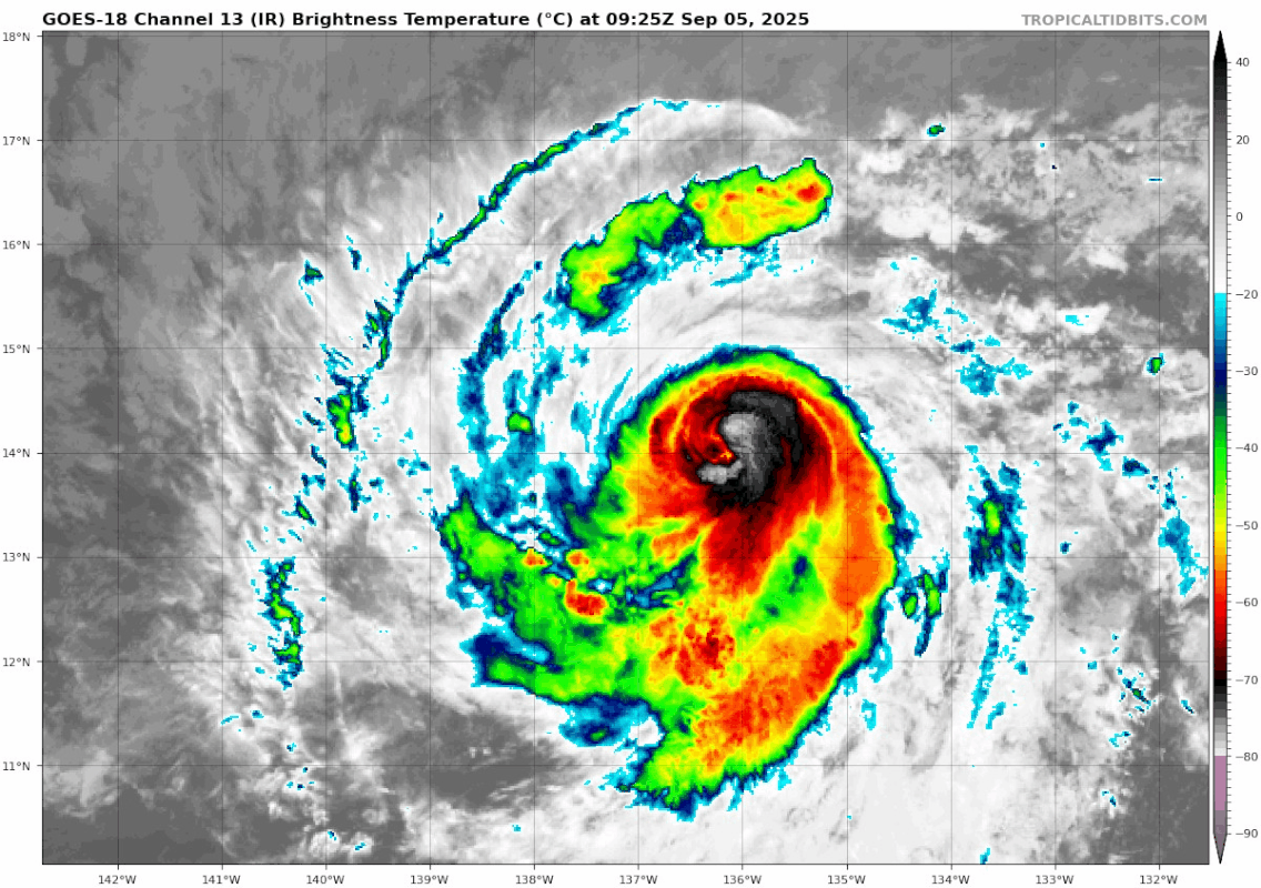
The satellite presentation of Kiko continues to slowly deteriorate
early this morning, with the eye obscured by high clouds emanating
from the coldest convective tops in the southeast quadrant. The
most recent subjective Dvorak current intensity estimates from TAFB
and SAB are T6.0/115 kt and T5.0/90 kt. Objective estimates,
including ADT from UW-CIMSS, are a bit on the lower end of the
spread between 90-100 knots. The intensity has been set at 100 kts
as a blend of the subjective and objective intensity estimates.
Kiko has made the expected turn to the west-northwest, or 285
degrees, at 8 kt. The western extent of a subtropical ridge to the
north of the cyclone is eroding by a developing upper-level low
north of Hawaii. This general west-northwestward motion along with
a gradual increase in forward speed is forecast into early next
week, as Kiko moves along the southwest periphery of this
subtropical ridge towards the upper-level low to the north and
northwest of the Hawaiian Islands. The latest track forecast early
on is very similar to the previous forecast, before being adjusted
somewhat to the north from Monday onward as increasing southwesterly
vertical wind shear leads to convective asymmetry which could induce
a jog to the right. The track forecast is closest to the HCCA
consensus.
Kiko will remain over warm waters of 27–28C for the next 18 hours,
while influenced by light northeasterly vertical wind shear,
although the cyclone will remain in a drier than optimal mid-level
environment keeping the storm size smaller than average. Despite
the dry mid-level airmass Kiko will be moving through, the other
factors still appear favorable for some slight intensification, so
the latest intensity forecast still shows a little short-term
strengthening. This forecast also fits in with the possibility for
Kiko to develop annular characteristics which could keep it stronger
than the forecast intensity guidance. Thereafter, Kiko will move
over slightly cooler waters and an even drier mid-level environment.
These less favorable conditions should begin a gradual weakening
trend, in spite of the very light vertical wind shear. Waters below
26 C await Kiko's track after Monday, with west-southwesterly
vertical wind shear increasing steadily to more than 30 kt by
Wednesday, making it more likely the nearby dry air gets imported
into Kiko's small core. The increasingly hostile environment should
lead to rapid weakening of the tropical cyclone as it approaches
the Hawaiian Islands from the east-southeast. The official
intensity forecast has been lowered slightly from the previous
advisory cycle, but remains on the higher end of the intensity aids
through 48 hours. The intensity forecast then trends closer to the
middle of the intensity consensus envelope by Monday, and then
trends lower as Kiko should convectively sputter while moving very
close to the eastern end of the Hawaiian Island chain as a weakening
tropical storm.
Key Messages:
1. Kiko is forecast to approach the Hawaiian Islands during the
early to the middle portion of next week. However, it is too soon to
determine the exact location or magnitude of these impacts, and
interests there should continue to monitor the progress of this
storm.
FORECAST POSITIONS AND MAX WINDS
INIT 05/1500Z 14.2N 137.1W 100 KT 115 MPH
12H 06/0000Z 14.5N 138.5W 100 KT 115 MPH
24H 06/1200Z 15.0N 140.3W 105 KT 120 MPH
36H 07/0000Z 15.7N 142.2W 105 KT 120 MPH
48H 07/1200Z 16.4N 144.2W 100 KT 115 MPH
60H 08/0000Z 17.5N 146.2W 95 KT 110 MPH
72H 08/1200Z 18.5N 148.4W 80 KT 90 MPH
96H 09/1200Z 20.7N 152.8W 55 KT 65 MPH
120H 10/1200Z 22.6N 157.5W 35 KT 40 MPH
$$
Forecaster Roth/Papin
Hurricane Kiko Advisory Number 22
NWS National Hurricane Center Miami FL EP112025
Issued by the NWS Weather Prediction Center College Park MD
500 AM HST Fri Sep 05 2025
...KIKO NOW MOVING TO THE WEST-NORTHWEST WELL TO THE EAST-SOUTHEAST
OF HAWAII...
SUMMARY OF 500 AM HST...1500 UTC...INFORMATION
----------------------------------------------
LOCATION...14.2N 137.1W
ABOUT 1245 MI...2005 KM ESE OF HILO HAWAII
ABOUT 1450 MI...2335 KM ESE OF HONOLULU HAWAII
MAXIMUM SUSTAINED WINDS...115 MPH...185 KM/H
PRESENT MOVEMENT...WNW OR 285 DEGREES AT 9 MPH...15 KM/H
MINIMUM CENTRAL PRESSURE...962 MB...28.41 INCHES
Hurricane Kiko Discussion Number 22
NWS National Hurricane Center Miami FL EP112025
Issued by the NWS Weather Prediction Center College Park MD
500 AM HST Fri Sep 05 2025
The satellite presentation of Kiko continues to slowly deteriorate
early this morning, with the eye obscured by high clouds emanating
from the coldest convective tops in the southeast quadrant. The
most recent subjective Dvorak current intensity estimates from TAFB
and SAB are T6.0/115 kt and T5.0/90 kt. Objective estimates,
including ADT from UW-CIMSS, are a bit on the lower end of the
spread between 90-100 knots. The intensity has been set at 100 kts
as a blend of the subjective and objective intensity estimates.
Kiko has made the expected turn to the west-northwest, or 285
degrees, at 8 kt. The western extent of a subtropical ridge to the
north of the cyclone is eroding by a developing upper-level low
north of Hawaii. This general west-northwestward motion along with
a gradual increase in forward speed is forecast into early next
week, as Kiko moves along the southwest periphery of this
subtropical ridge towards the upper-level low to the north and
northwest of the Hawaiian Islands. The latest track forecast early
on is very similar to the previous forecast, before being adjusted
somewhat to the north from Monday onward as increasing southwesterly
vertical wind shear leads to convective asymmetry which could induce
a jog to the right. The track forecast is closest to the HCCA
consensus.
Kiko will remain over warm waters of 27–28C for the next 18 hours,
while influenced by light northeasterly vertical wind shear,
although the cyclone will remain in a drier than optimal mid-level
environment keeping the storm size smaller than average. Despite
the dry mid-level airmass Kiko will be moving through, the other
factors still appear favorable for some slight intensification, so
the latest intensity forecast still shows a little short-term
strengthening. This forecast also fits in with the possibility for
Kiko to develop annular characteristics which could keep it stronger
than the forecast intensity guidance. Thereafter, Kiko will move
over slightly cooler waters and an even drier mid-level environment.
These less favorable conditions should begin a gradual weakening
trend, in spite of the very light vertical wind shear. Waters below
26 C await Kiko's track after Monday, with west-southwesterly
vertical wind shear increasing steadily to more than 30 kt by
Wednesday, making it more likely the nearby dry air gets imported
into Kiko's small core. The increasingly hostile environment should
lead to rapid weakening of the tropical cyclone as it approaches
the Hawaiian Islands from the east-southeast. The official
intensity forecast has been lowered slightly from the previous
advisory cycle, but remains on the higher end of the intensity aids
through 48 hours. The intensity forecast then trends closer to the
middle of the intensity consensus envelope by Monday, and then
trends lower as Kiko should convectively sputter while moving very
close to the eastern end of the Hawaiian Island chain as a weakening
tropical storm.
Key Messages:
1. Kiko is forecast to approach the Hawaiian Islands during the
early to the middle portion of next week. However, it is too soon to
determine the exact location or magnitude of these impacts, and
interests there should continue to monitor the progress of this
storm.
FORECAST POSITIONS AND MAX WINDS
INIT 05/1500Z 14.2N 137.1W 100 KT 115 MPH
12H 06/0000Z 14.5N 138.5W 100 KT 115 MPH
24H 06/1200Z 15.0N 140.3W 105 KT 120 MPH
36H 07/0000Z 15.7N 142.2W 105 KT 120 MPH
48H 07/1200Z 16.4N 144.2W 100 KT 115 MPH
60H 08/0000Z 17.5N 146.2W 95 KT 110 MPH
72H 08/1200Z 18.5N 148.4W 80 KT 90 MPH
96H 09/1200Z 20.7N 152.8W 55 KT 65 MPH
120H 10/1200Z 22.6N 157.5W 35 KT 40 MPH
$$
Forecaster Roth/Papin
0 likes
Visit the Caribbean-Central America Weather Thread where you can find at first post web cams,radars
and observations from Caribbean basin members Click Here
and observations from Caribbean basin members Click Here
-
Kingarabian
- S2K Supporter
- Posts: 16379
- Joined: Sat Aug 08, 2009 3:06 am
- Location: Honolulu, Hawaii
Re: EPAC: KIKO - Hurricane - Discussion
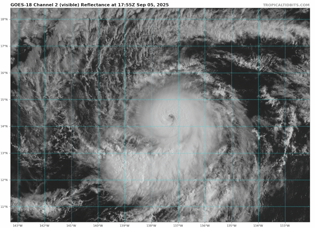
Kiko is making a comeback. Likely its last hurrah unless it can transition to annular.
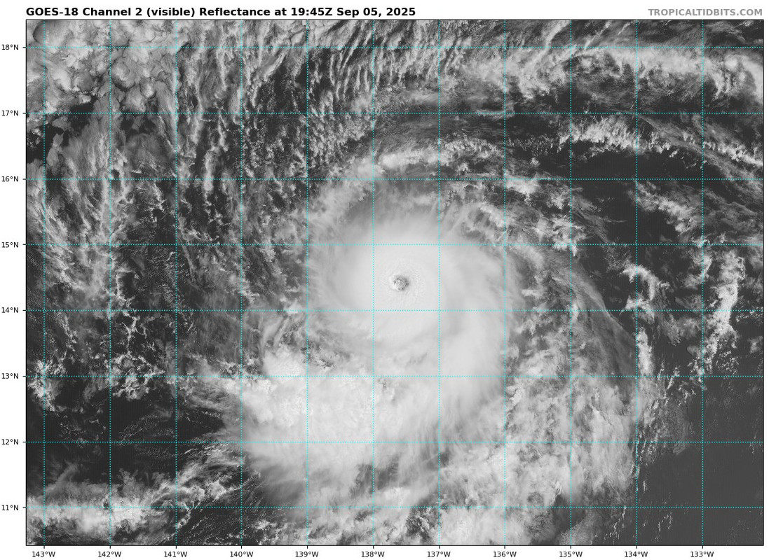
WMG eye since eye temp looks to be over +9C. If the B / W rings meet the thickness criteria, would be a T6.5 on Dvorak. If not, then it's at least a T6.0 with LG/B.
WMG eye since eye temp looks to be over +9C. If the B / W rings meet the thickness criteria, would be a T6.5 on Dvorak. If not, then it's at least a T6.0 with LG/B.
0 likes
RIP Kobe Bryant
-
Kingarabian
- S2K Supporter
- Posts: 16379
- Joined: Sat Aug 08, 2009 3:06 am
- Location: Honolulu, Hawaii
Re: EPAC: KIKO - Hurricane - Discussion
Only models showing some type of impacts are the UKMET and CMC. Rest have shifted ENE of Hawaii.
0 likes
RIP Kobe Bryant
-
Kingarabian
- S2K Supporter
- Posts: 16379
- Joined: Sat Aug 08, 2009 3:06 am
- Location: Honolulu, Hawaii
-
Kingarabian
- S2K Supporter
- Posts: 16379
- Joined: Sat Aug 08, 2009 3:06 am
- Location: Honolulu, Hawaii
-
ElectricStorm

- Category 5
- Posts: 5155
- Age: 25
- Joined: Tue Aug 13, 2019 11:23 pm
- Location: Norman, OK
Re: EPAC: KIKO - Hurricane - Discussion
Probably back up to 115kts+ again, hopefully NHC goes higher than 18z BT
1 likes
B.S Meteorology, University of Oklahoma '25
Please refer to the NHC, NWS, or SPC for official information.
Please refer to the NHC, NWS, or SPC for official information.
-
Kingarabian
- S2K Supporter
- Posts: 16379
- Joined: Sat Aug 08, 2009 3:06 am
- Location: Honolulu, Hawaii
-
Kingarabian
- S2K Supporter
- Posts: 16379
- Joined: Sat Aug 08, 2009 3:06 am
- Location: Honolulu, Hawaii
Re: EPAC: KIKO - Hurricane - Discussion
Past 2 frames it's running back up to a T6.5.
0 likes
RIP Kobe Bryant
-
StormWeather

- Category 1

- Posts: 477
- Joined: Wed Jun 05, 2024 2:34 pm
Re: EPAC: KIKO - Hurricane - Discussion
Kiko is once again a Category 4, and the new forecast peak is 125 kts.
HURRICANE KIKO FORECAST/ADVISORY NUMBER 23
NWS NATIONAL HURRICANE CENTER MIAMI FL EP112025
ISSUED BY THE NWS WEATHER PREDICTION CENTER COLLEGE PARK MD
2100 UTC FRI SEP 05 2025
HURRICANE CENTER LOCATED NEAR 14.5N 137.8W AT 05/2100Z
POSITION ACCURATE WITHIN 30 NM
PRESENT MOVEMENT TOWARD THE WEST-NORTHWEST OR 290 DEGREES AT 9 KT
ESTIMATED MINIMUM CENTRAL PRESSURE 951 MB
MAX SUSTAINED WINDS 115 KT WITH GUSTS TO 140 KT.
64 KT....... 20NE 20SE 15SW 20NW.
50 KT....... 30NE 40SE 25SW 30NW.
34 KT....... 50NE 60SE 50SW 50NW.
4 M SEAS.... 90NE 90SE 90SW 90NW.
WINDS AND SEAS VARY GREATLY IN EACH QUADRANT. RADII IN NAUTICAL
MILES ARE THE LARGEST RADII EXPECTED ANYWHERE IN THAT QUADRANT.
REPEAT...CENTER LOCATED NEAR 14.5N 137.8W AT 05/2100Z
AT 05/1800Z CENTER WAS LOCATED NEAR 14.3N 137.3W
FORECAST VALID 06/0600Z 14.9N 139.1W
MAX WIND 125 KT WITH GUSTS 150 KT.
64 KT... 20NE 20SE 10SW 20NW.
50 KT... 30NE 30SE 20SW 30NW.
34 KT... 50NE 50SE 40SW 60NW.
BULLETIN
Hurricane Kiko Advisory Number 23
NWS National Hurricane Center Miami FL EP112025
Issued by the NWS Weather Prediction Center College Park MD
1100 AM HST Fri Sep 05 2025
...KIKO QUICKLY RE-INTENSIFIES INTO A CATEGORY FOUR HURRICANE AS IT
APPROACHES THE CENTRAL PACIFIC BASIN...
SUMMARY OF 1100 AM HST...2100 UTC...INFORMATION
-----------------------------------------------
LOCATION...14.5N 137.8W
ABOUT 1195 MI...1925 KM ESE OF HILO HAWAII
ABOUT 1400 MI...2255 KM ESE OF HONOLULU HAWAII
MAXIMUM SUSTAINED WINDS...130 MPH...215 KM/H
PRESENT MOVEMENT...WNW OR 290 DEGREES AT 10 MPH...17 KM/H
MINIMUM CENTRAL PRESSURE...951 MB...28.09 INCHES
Hurricane Kiko Discussion Number 23
NWS National Hurricane Center Miami FL EP112025
Issued by the NWS Weather Prediction Center College Park MD
1100 AM HST Fri Sep 05 2025
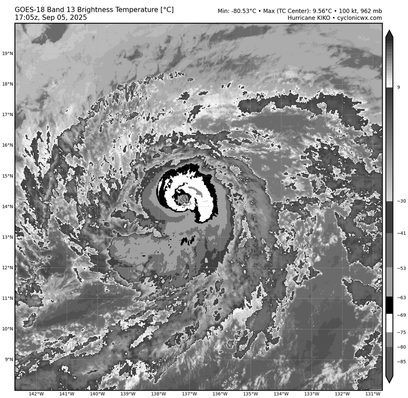
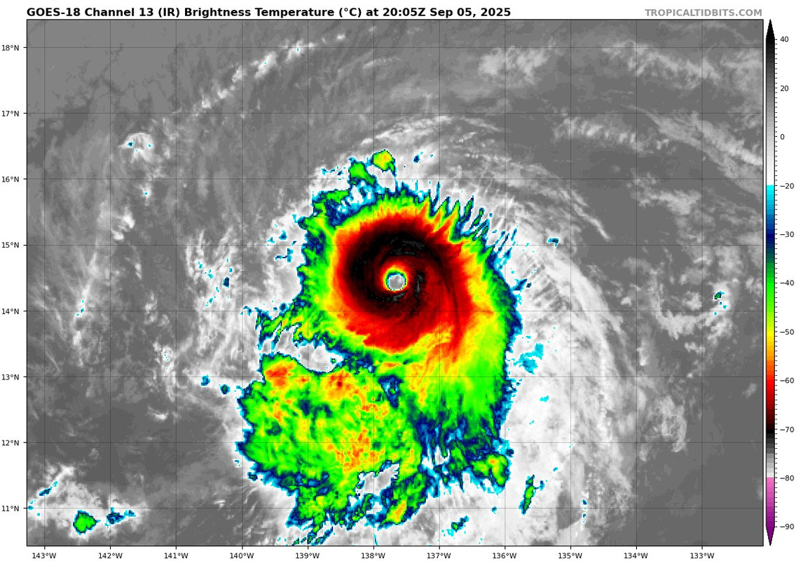
The satellite presentation of Kiko has shown significant improvement
since the last advisory, with the eye clearing out and its coldest
cloud tops more fully encircling it. The most recent subjective
Dvorak current intensity estimates from TAFB and SAB were T6.0/115
kt and T5.5/102 kt. Objective estimates from UW-CIMSS have been
increasing, with the latest ADT estimate up to to 115 knots.
Considering the continuing improvement since the time of the 1800
UTC fixes, the intensity has been set at 115 kts, which could be
conservative as the eye continues to clear out.
Kiko continues to move to the west-northwest, or 290 degrees, at 9
kt. The western extent of a subtropical ridge to the north of the
cyclone is eroding due to a developing upper-level low north of
Hawaii. This general west-northwestward motion along with a gradual
increase in forward speed is forecast into early next week, as Kiko
moves along the southwest periphery of this subtropical ridge and
towards the upper-level low to the north and northwest of the
Hawaiian Islands. The track forecast has shifted northward due to
the slightly more northward initial motion, and poleward shift in
the track guidance. Based on the forecast track Kiko is expected to
cross 140W into the central Pacific Ocean overnight into Saturday
morning. The track forecast remains close to the HCCA consensus
aid. By the end of the forecast track, Kiko may turn more westward
as it becomes increasingly steered by the low-level flow.
The hurricane will remain over warm waters of 27–28C for the next 12
hours, while influenced by light northeasterly vertical wind shear
embedded in a drier than normal mid-level environment. These
environmental factors should keep Kiko a smaller than average sized
storm as the dry air prevents more prominent outer rain bands from
forming. Conditions still appear favorable for additional
intensification, so the latest intensity and given the current
improving structure, more intensification is shown than before, well
above all of the available guidance. This forecast also fits in
with the possibility for Kiko developing annular structure which
could keep it stronger than the forecast intensity guidance.
Thereafter, Kiko will move over cooler waters and an even drier
mid-level environment. After 48 hours, west-southwesterly vertical
wind shear increases steadily, exceeding 30 kt by Wednesday. This
shear may help import the nearby environmental dry air into Kiko's
small core. Thus, rapid weakening of the tropical cyclone is
forecast as Kiko passes to the northeast of the Hawaiian Islands by
the end of the forecast. After the initial bump in short-term
intensity, this forecast trends back to the middle of the consensus
envelope early next week, and then trends lower by the end of the
forecast period.
Key Messages:
1. Kiko is forecast to approach the Hawaiian Islands during the
early to the middle portion of next week. Impacts from rain and wind
remain a possibility, but it is too soon to determine the exact
location or magnitude of these impacts, and interests there should
continue to monitor the progress of this storm.
FORECAST POSITIONS AND MAX WINDS
INIT 05/2100Z 14.5N 137.8W 115 KT 130 MPH
12H 06/0600Z 14.9N 139.1W 125 KT 145 MPH
24H 06/1800Z 15.6N 141.0W 120 KT 140 MPH
36H 07/0600Z 16.3N 143.0W 115 KT 130 MPH
48H 07/1800Z 17.2N 145.0W 100 KT 115 MPH
60H 08/0600Z 18.2N 147.0W 90 KT 105 MPH
72H 08/1800Z 19.4N 149.1W 75 KT 85 MPH
96H 09/1800Z 21.7N 153.5W 50 KT 60 MPH
120H 10/1800Z 23.7N 158.2W 35 KT 40 MPH
NWS NATIONAL HURRICANE CENTER MIAMI FL EP112025
ISSUED BY THE NWS WEATHER PREDICTION CENTER COLLEGE PARK MD
2100 UTC FRI SEP 05 2025
HURRICANE CENTER LOCATED NEAR 14.5N 137.8W AT 05/2100Z
POSITION ACCURATE WITHIN 30 NM
PRESENT MOVEMENT TOWARD THE WEST-NORTHWEST OR 290 DEGREES AT 9 KT
ESTIMATED MINIMUM CENTRAL PRESSURE 951 MB
MAX SUSTAINED WINDS 115 KT WITH GUSTS TO 140 KT.
64 KT....... 20NE 20SE 15SW 20NW.
50 KT....... 30NE 40SE 25SW 30NW.
34 KT....... 50NE 60SE 50SW 50NW.
4 M SEAS.... 90NE 90SE 90SW 90NW.
WINDS AND SEAS VARY GREATLY IN EACH QUADRANT. RADII IN NAUTICAL
MILES ARE THE LARGEST RADII EXPECTED ANYWHERE IN THAT QUADRANT.
REPEAT...CENTER LOCATED NEAR 14.5N 137.8W AT 05/2100Z
AT 05/1800Z CENTER WAS LOCATED NEAR 14.3N 137.3W
FORECAST VALID 06/0600Z 14.9N 139.1W
MAX WIND 125 KT WITH GUSTS 150 KT.
64 KT... 20NE 20SE 10SW 20NW.
50 KT... 30NE 30SE 20SW 30NW.
34 KT... 50NE 50SE 40SW 60NW.
BULLETIN
Hurricane Kiko Advisory Number 23
NWS National Hurricane Center Miami FL EP112025
Issued by the NWS Weather Prediction Center College Park MD
1100 AM HST Fri Sep 05 2025
...KIKO QUICKLY RE-INTENSIFIES INTO A CATEGORY FOUR HURRICANE AS IT
APPROACHES THE CENTRAL PACIFIC BASIN...
SUMMARY OF 1100 AM HST...2100 UTC...INFORMATION
-----------------------------------------------
LOCATION...14.5N 137.8W
ABOUT 1195 MI...1925 KM ESE OF HILO HAWAII
ABOUT 1400 MI...2255 KM ESE OF HONOLULU HAWAII
MAXIMUM SUSTAINED WINDS...130 MPH...215 KM/H
PRESENT MOVEMENT...WNW OR 290 DEGREES AT 10 MPH...17 KM/H
MINIMUM CENTRAL PRESSURE...951 MB...28.09 INCHES
Hurricane Kiko Discussion Number 23
NWS National Hurricane Center Miami FL EP112025
Issued by the NWS Weather Prediction Center College Park MD
1100 AM HST Fri Sep 05 2025
The satellite presentation of Kiko has shown significant improvement
since the last advisory, with the eye clearing out and its coldest
cloud tops more fully encircling it. The most recent subjective
Dvorak current intensity estimates from TAFB and SAB were T6.0/115
kt and T5.5/102 kt. Objective estimates from UW-CIMSS have been
increasing, with the latest ADT estimate up to to 115 knots.
Considering the continuing improvement since the time of the 1800
UTC fixes, the intensity has been set at 115 kts, which could be
conservative as the eye continues to clear out.
Kiko continues to move to the west-northwest, or 290 degrees, at 9
kt. The western extent of a subtropical ridge to the north of the
cyclone is eroding due to a developing upper-level low north of
Hawaii. This general west-northwestward motion along with a gradual
increase in forward speed is forecast into early next week, as Kiko
moves along the southwest periphery of this subtropical ridge and
towards the upper-level low to the north and northwest of the
Hawaiian Islands. The track forecast has shifted northward due to
the slightly more northward initial motion, and poleward shift in
the track guidance. Based on the forecast track Kiko is expected to
cross 140W into the central Pacific Ocean overnight into Saturday
morning. The track forecast remains close to the HCCA consensus
aid. By the end of the forecast track, Kiko may turn more westward
as it becomes increasingly steered by the low-level flow.
The hurricane will remain over warm waters of 27–28C for the next 12
hours, while influenced by light northeasterly vertical wind shear
embedded in a drier than normal mid-level environment. These
environmental factors should keep Kiko a smaller than average sized
storm as the dry air prevents more prominent outer rain bands from
forming. Conditions still appear favorable for additional
intensification, so the latest intensity and given the current
improving structure, more intensification is shown than before, well
above all of the available guidance. This forecast also fits in
with the possibility for Kiko developing annular structure which
could keep it stronger than the forecast intensity guidance.
Thereafter, Kiko will move over cooler waters and an even drier
mid-level environment. After 48 hours, west-southwesterly vertical
wind shear increases steadily, exceeding 30 kt by Wednesday. This
shear may help import the nearby environmental dry air into Kiko's
small core. Thus, rapid weakening of the tropical cyclone is
forecast as Kiko passes to the northeast of the Hawaiian Islands by
the end of the forecast. After the initial bump in short-term
intensity, this forecast trends back to the middle of the consensus
envelope early next week, and then trends lower by the end of the
forecast period.
Key Messages:
1. Kiko is forecast to approach the Hawaiian Islands during the
early to the middle portion of next week. Impacts from rain and wind
remain a possibility, but it is too soon to determine the exact
location or magnitude of these impacts, and interests there should
continue to monitor the progress of this storm.
FORECAST POSITIONS AND MAX WINDS
INIT 05/2100Z 14.5N 137.8W 115 KT 130 MPH
12H 06/0600Z 14.9N 139.1W 125 KT 145 MPH
24H 06/1800Z 15.6N 141.0W 120 KT 140 MPH
36H 07/0600Z 16.3N 143.0W 115 KT 130 MPH
48H 07/1800Z 17.2N 145.0W 100 KT 115 MPH
60H 08/0600Z 18.2N 147.0W 90 KT 105 MPH
72H 08/1800Z 19.4N 149.1W 75 KT 85 MPH
96H 09/1800Z 21.7N 153.5W 50 KT 60 MPH
120H 10/1800Z 23.7N 158.2W 35 KT 40 MPH
Last edited by StormWeather on Fri Sep 05, 2025 3:44 pm, edited 1 time in total.
1 likes
Just an average cyclone tracker
The posts in this forum are NOT official forecasts and should not be used as such. They are just the opinion of the poster and may or may not be backed by sound meteorological data. They are NOT endorsed by any professional institution or storm2k.org. For official information, please refer to the NHC and NWS products
The posts in this forum are NOT official forecasts and should not be used as such. They are just the opinion of the poster and may or may not be backed by sound meteorological data. They are NOT endorsed by any professional institution or storm2k.org. For official information, please refer to the NHC and NWS products


Re: EPAC: KIKO - Hurricane - Discussion
So Kiko manages to become annular after all. Should extend its time as a major somewhat. The basin needs more ACE to catch up with the climatological average especially since there is no storm waiting to form at the moment.
0 likes
Who is online
Users browsing this forum: No registered users and 68 guests