https://x.com/NHC_TAFB/status/1963685306135166998
ATL: Ex INVEST 91L - Discussion (0/0)
Moderator: S2k Moderators
-
cycloneye

- Admin

- Posts: 149691
- Age: 69
- Joined: Thu Oct 10, 2002 10:54 am
- Location: San Juan, Puerto Rico
Re: ATL: INVEST 91L - Discussion (60/90)
2 likes
Visit the Caribbean-Central America Weather Thread where you can find at first post web cams,radars
and observations from Caribbean basin members Click Here
and observations from Caribbean basin members Click Here
-
cycloneye
- Admin
- Posts: 149691
- Age: 69
- Joined: Thu Oct 10, 2002 10:54 am
- Location: San Juan, Puerto Rico
Re: ATL: INVEST 91L - Discussion (60/90)
18z Best Track:

AL, 91, 2025090418, , BEST, 0, 121N, 342W, 20, 1011, DB
1 likes
Visit the Caribbean-Central America Weather Thread where you can find at first post web cams,radars
and observations from Caribbean basin members Click Here
and observations from Caribbean basin members Click Here
-
Hurrilurker

- Category 2

- Posts: 738
- Joined: Mon Jun 09, 2003 3:32 pm
- Location: San Francisco, CA
Re: ATL: INVEST 91L - Discussion (60/90)
That NHC "development cone" keeps steadily ticking more and more south on the west end.
3 likes
-
SconnieCane
- Category 5

- Posts: 1013
- Joined: Thu Aug 02, 2018 5:29 pm
- Location: Madison, WI
Re: ATL: INVEST 91L - Discussion (60/90)
Oh *bleep,* that new red shaded zone of potential formation (not yet really a "cone" based on track forecast points, remember) is a lot further southwest and now encompasses portions of the northern, central AND southern Lesser Antilles.
Operational global runs are well-nigh useless for intensity at this range. There might be a TUTT that imparts detrimental shear on it, there might not.
Operational global runs are well-nigh useless for intensity at this range. There might be a TUTT that imparts detrimental shear on it, there might not.
2 likes
-
cycloneye
- Admin
- Posts: 149691
- Age: 69
- Joined: Thu Oct 10, 2002 10:54 am
- Location: San Juan, Puerto Rico
Re: ATL: INVEST 91L - Discussion (60/90)
0 likes
Visit the Caribbean-Central America Weather Thread where you can find at first post web cams,radars
and observations from Caribbean basin members Click Here
and observations from Caribbean basin members Click Here
-
Blown Away

- S2K Supporter

- Posts: 10253
- Joined: Wed May 26, 2004 6:17 am
Re: ATL: INVEST 91L - Discussion (60/90)
cycloneye wrote:18z Best Track:AL, 91, 2025090418, , BEST, 0, 121N, 342W, 20, 1011, DB
91L may be consolidating a bit north of 12.1N/34.2W?
0 likes
Hurricane Eye Experience: David 79, Irene 99, Frances 04, Jeanne 04, Wilma 05… Hurricane Brush Experience: Andrew 92, Erin 95, Floyd 99, Matthew 16, Irma 17, Ian 22, Nicole 22…

Re: ATL: INVEST 91L - Discussion (60/90)
What time frame are we looking at IF it comes into the Gulf? Trying to make plans for a surgery.
2 likes
Alicia, Rita, Ike, Harvey and Beryl...moved to Splendora lol
-
ouragans

- Category 2
- Posts: 501
- Age: 54
- Joined: Sun Jun 12, 2011 12:09 pm
- Location: Abymes, Guadeloupe F.W.I
- Contact:
Re: ATL: INVEST 91L - Discussion (60/90)
mpic wrote:What time frame are we looking at IF it comes into the Gulf? Trying to make plans for a surgery.
More than 14 days
1 likes
Personal forecast disclaimer
This post is a personal point of view, not an information. Please refer to official statements for life-threatening decisions.
David '79, Frederic '79, Hugo '89, Iris, Luis & Marilyn '95, Georges '98, Lenny '99, Dean '07, Irma '17, Maria '17, Fiona '22, Philippe '23, Tammy '23
16°13'33.3,"6N -61°36'39.5"W
-
cycloneye
- Admin
- Posts: 149691
- Age: 69
- Joined: Thu Oct 10, 2002 10:54 am
- Location: San Juan, Puerto Rico
Re: ATL: INVEST 91L - Discussion (60/90)
5 likes
Visit the Caribbean-Central America Weather Thread where you can find at first post web cams,radars
and observations from Caribbean basin members Click Here
and observations from Caribbean basin members Click Here
-
cycloneye
- Admin
- Posts: 149691
- Age: 69
- Joined: Thu Oct 10, 2002 10:54 am
- Location: San Juan, Puerto Rico
Re: ATL: INVEST 91L - Discussion (60/90)
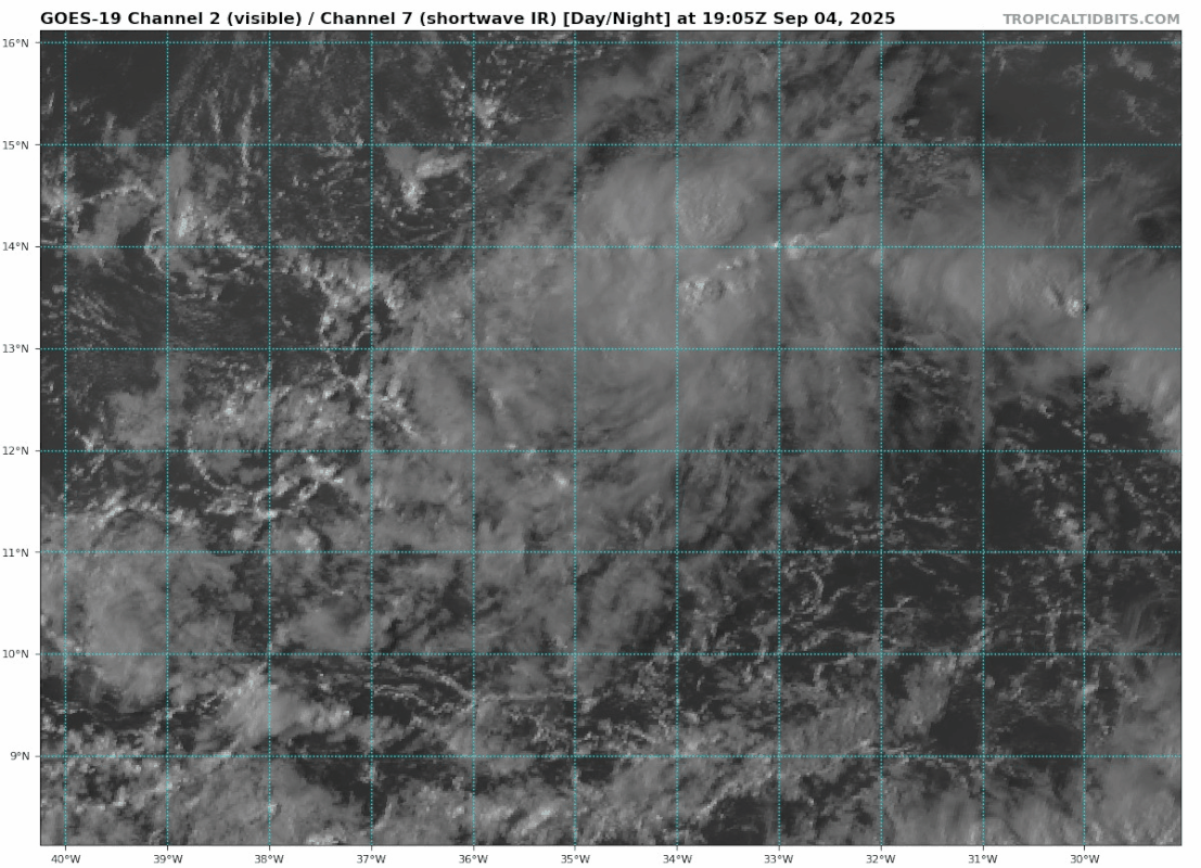
Tropical Weather Outlook
NWS National Hurricane Center Miami FL
800 PM EDT Thu Sep 4 2025
For the North Atlantic...Caribbean Sea and the Gulf of America:
Tropical Atlantic (AL91):
A broad area of low pressure, associated with a tropical wave, is
producing a concentrated but still disorganized area of showers and
thunderstorms over the eastern tropical Atlantic. Environmental
conditions are favorable for development of this system, and a
tropical depression is likely to form by this weekend as it moves
slowly westward at 5 to 10 mph across the central tropical Atlantic.
This system is likely to be near the Lesser Antilles by the middle
to latter part of next week, and interests there should continue to
monitor its progress.
* Formation chance through 48 hours...medium...60 percent.
* Formation chance through 7 days...high...90 percent.
$$
Forecaster Berg
3 likes
Visit the Caribbean-Central America Weather Thread where you can find at first post web cams,radars
and observations from Caribbean basin members Click Here
and observations from Caribbean basin members Click Here

Re: ATL: INVEST 91L - Discussion (60/90)
Someone wake up Wxman or any of the other dozen or so Pro Mets here LOL. Peak week of the season with a 60/90 MDR Invest, along with models that are throwing a grab-bag of intensity & track solutions. Yet, mum's the word from any of them (or Levi for that matter)?? 
2 likes
Andy D
(For official information, please refer to the NHC and NWS products.)
(For official information, please refer to the NHC and NWS products.)
Re: ATL: INVEST 91L - Discussion (60/90)
chaser1 wrote:Someone wake up Wxman or any of the other dozen or so Pro Mets here LOL. Peak week of the season with a 60/90 MDR Invest, along with models that are throwing a grab-bag of intensity & track solutions. Yet, mum's the word from any of them (or Levi for that matter)??
I've been checking Levi's website and nothing yet but he was probably waiting for it to be declared an invest so he should have something to say soon.
1 likes
Re: ATL: INVEST 91L - Discussion (60/90)
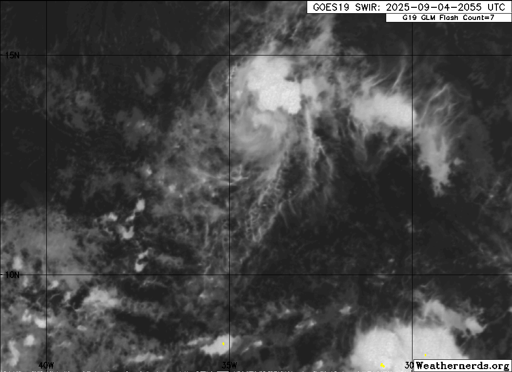
18z best track was 12.1N but this looks more like 13.5N. Probably another round of model changes overnight.
0 likes
-
Deshaunrob17
- Tropical Storm

- Posts: 211
- Joined: Tue Aug 18, 2020 7:49 am
Re: ATL: INVEST 91L - Discussion (60/90)
I’m not surprised one bit that Euro has it weak. Models won’t handle this system properly.
1. Lots of dry air keeping it small- reminds me of how Dorian started .
2. A wave still embedded within the monsoon mess.
I won’t trust models as yet. Also, never trust these small system during the peak of season.
1. Lots of dry air keeping it small- reminds me of how Dorian started .
2. A wave still embedded within the monsoon mess.
I won’t trust models as yet. Also, never trust these small system during the peak of season.
2 likes
-
cycloneye
- Admin
- Posts: 149691
- Age: 69
- Joined: Thu Oct 10, 2002 10:54 am
- Location: San Juan, Puerto Rico
Re: ATL: INVEST 91L - Discussion (60/90)
More south.

AL, 91, 2025090500, , BEST, 0, 117N, 346W, 20, 1011, DB
1 likes
Visit the Caribbean-Central America Weather Thread where you can find at first post web cams,radars
and observations from Caribbean basin members Click Here
and observations from Caribbean basin members Click Here
Re: ATL: INVEST 91L - Discussion (60/90)
cycloneye wrote:More south.AL, 91, 2025090500, , BEST, 0, 117N, 346W, 20, 1011, DB
https://i.imgur.com/VW0f3rB.png
This is starting to look a little spooky!!
1 likes
Re: ATL: INVEST 91L - Discussion (60/90)
cycloneye wrote:More south.AL, 91, 2025090500, , BEST, 0, 117N, 346W, 20, 1011, DB
https://i.imgur.com/VW0f3rB.png
2 likes
Andy D
(For official information, please refer to the NHC and NWS products.)
(For official information, please refer to the NHC and NWS products.)

Re: ATL: INVEST 91L - Discussion (60/90)
BobHarlem wrote:18z best track was 12.1N but this looks more like 13.5N. Probably another round of model changes overnight.
https://i.postimg.cc/Qd5ZGcWp/48741101.gif
91L's mid-level vorticity is well to the north of low-level now, so it could simply be that what we're seeing from satellite at 13-14N isn't making it down to the surface.
If upcoming convective bursts tonight continue to focus around 14N, I wouldn't be surprised if it consolidates further north. That said, the hurricane models seem to suggest that convection will spread from 11N to 14N tonight.
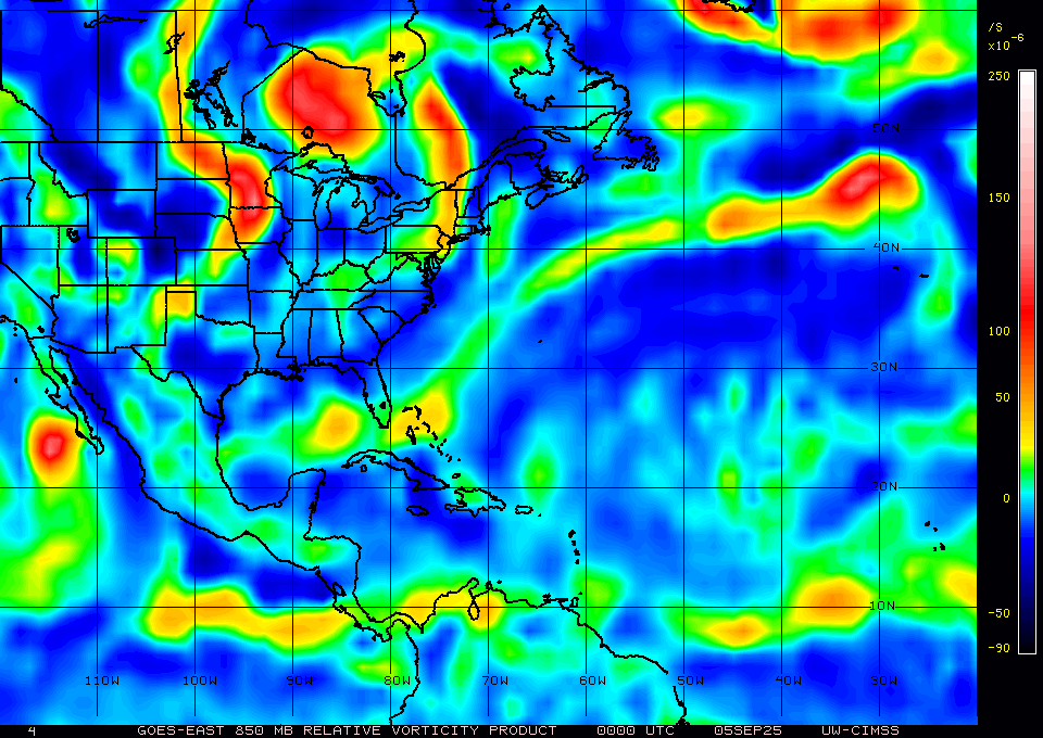
850-700-500 mb vorticity:
0 likes
TC naming lists: retirements and intensity
Most aggressive Advisory #1's in North Atlantic (cr. kevin for starting the list)
Most aggressive Advisory #1's in North Atlantic (cr. kevin for starting the list)
Re: ATL: INVEST 91L - Discussion (60/90)
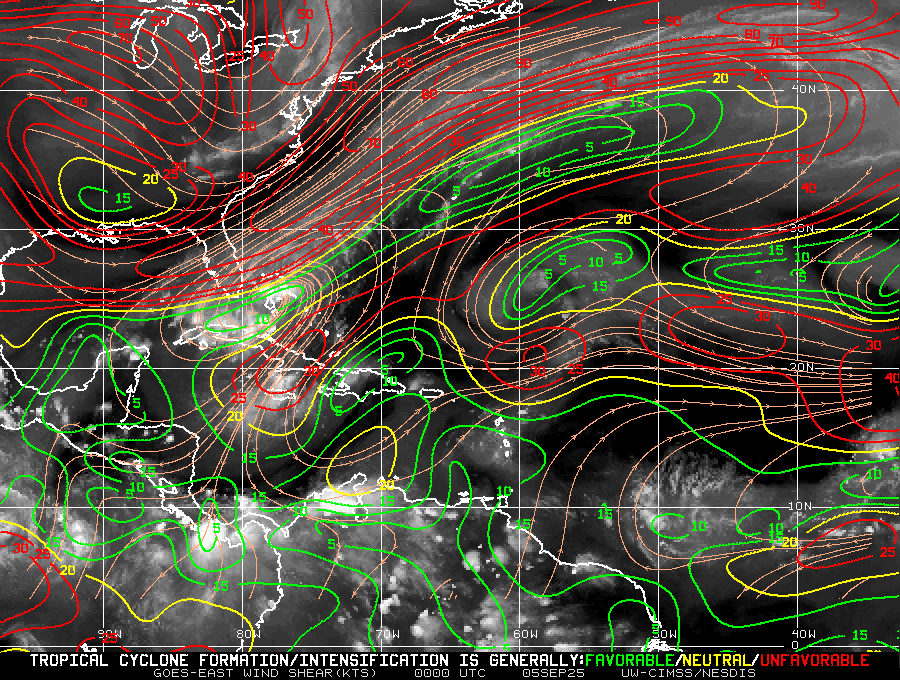
91L is also at a boundary with high shear to the north and low shear to the south, possibly explaining the discrepancy:
0 likes
TC naming lists: retirements and intensity
Most aggressive Advisory #1's in North Atlantic (cr. kevin for starting the list)
Most aggressive Advisory #1's in North Atlantic (cr. kevin for starting the list)
Re: ATL: INVEST 91L - Discussion (60/90)
Albeit slowly, 91L appears to already be moving west of any near term upper level shear (whether it be at 11.5 N or 14.0 N). Point being, the MLC is dominant and it's 2 degrees north of Best Track. My eyes are having a hard time unseeing that.
1 likes
Andy D
(For official information, please refer to the NHC and NWS products.)
(For official information, please refer to the NHC and NWS products.)
Who is online
Users browsing this forum: No registered users and 72 guests