
ATL: Ex-INVEST 91L - Models
Moderator: S2k Moderators
Re: ATL: INVEST 91L - Models
Barbados gets the right front quad here (a lot closer than Beryl got last year to it). Then it goes right over St. Lucia.


Last edited by BobHarlem on Thu Sep 04, 2025 11:27 pm, edited 1 time in total.
0 likes
Re: ATL: INVEST 91L - Models
The 0Z CMC is similar to the GFS in being further S than its prior run and is close to the 0Z GFS as of 144.
0 likes
Personal Forecast Disclaimer:
The posts in this forum are NOT official forecasts and should not be used as such. They are just the opinion of the poster and may or may not be backed by sound meteorological data. They are NOT endorsed by any professional institution or storm2k.org. For official information, please refer to the NHC and NWS products.
The posts in this forum are NOT official forecasts and should not be used as such. They are just the opinion of the poster and may or may not be backed by sound meteorological data. They are NOT endorsed by any professional institution or storm2k.org. For official information, please refer to the NHC and NWS products.
Re: ATL: INVEST 91L - Models
0z Canadian goes right over Martinique, big change from 12z which curved north of the islands. (it goes north of Barbados)

Then over St. Croix and the other US Virgin Islands, then clips the northeastern tip of Puerto Rico.

Final 0z Canadian frame, moving wnw here with strong ridging still.


Then over St. Croix and the other US Virgin Islands, then clips the northeastern tip of Puerto Rico.

Final 0z Canadian frame, moving wnw here with strong ridging still.

Last edited by BobHarlem on Thu Sep 04, 2025 11:50 pm, edited 5 times in total.
0 likes
Re: ATL: INVEST 91L - Models
Looks like an upper trough is going to do some serious damage on it as it moves through the Caribbean on this run.
0 likes
Re: ATL: INVEST 91L - Models
0z GFS goes right over the heart of the "shredder" in Hispaniola. The ridge is pretty strong, looks like it wants to go to Florida again, or at least visit Cuba a bit before so.


1 likes
-
Stratton23
- Category 5

- Posts: 3574
- Joined: Fri Jul 21, 2023 10:59 pm
- Location: Katy, Tx
Re: ATL: INVEST 91L - Models
I dont like seeing the trend of that trough over the eastern US trending weaker and moving out faster, seems like the trend is toward stronger ridging
0 likes
Re: ATL: INVEST 91L - Models
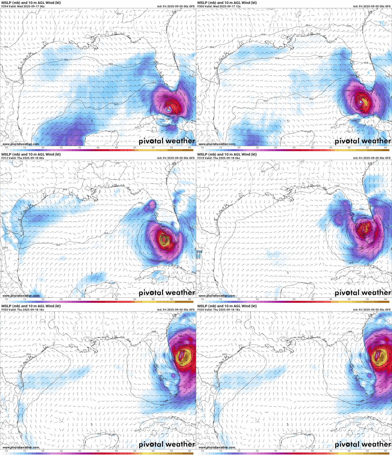
Key West landfall, followed by Naples/Marco Island and over lake Okeechobee, may be a setup for another east coast landfall past Florida also.



0 likes
Re: ATL: INVEST 91L - Models
0Z GEFS is still pretty anemic. It does have one member that passes to the north of Trinidad and Tobago.
0 likes
Re: ATL: INVEST 91L - Models
Both HAFS models seem to develop it a bit more in the next 72 hours.
0 likes
-
Stratton23
- Category 5

- Posts: 3574
- Joined: Fri Jul 21, 2023 10:59 pm
- Location: Katy, Tx
Re: ATL: INVEST 91L - Models
And the Euro just went ka poof completely, 91L dies out before ever getting to the leeward islands
0 likes
-
AxaltaRacing24
- Category 5

- Posts: 1774
- Age: 25
- Joined: Wed Jul 27, 2016 11:14 am
- Location: Jupiter, FL
Re: ATL: INVEST 91L - Models
Stratton23 wrote:And the Euro just went ka poof completely, 91L dies out before ever getting to the leeward islands
Maybe the Euro will be right, but it just has not seemed great this season so far.
0 likes
-
Stratton23
- Category 5

- Posts: 3574
- Joined: Fri Jul 21, 2023 10:59 pm
- Location: Katy, Tx
Re: ATL: INVEST 91L - Models
GFS caved to the Euro in terms of a more southern track, but ensemble support has really started to fall off, i guess we will just have to see what 91L looks like tomorrow
1 likes
- cycloneye
- Admin

- Posts: 149708
- Age: 69
- Joined: Thu Oct 10, 2002 10:54 am
- Location: San Juan, Puerto Rico
Re: ATL: INVEST 91L - Models
A growing trend? 06z ICON barely develops.
0 likes
Visit the Caribbean-Central America Weather Thread where you can find at first post web cams,radars
and observations from Caribbean basin members Click Here
and observations from Caribbean basin members Click Here
-
Cachondo23
- Tropical Storm

- Posts: 131
- Joined: Wed May 25, 2022 5:56 am
Re: ATL: INVEST 91L - Models
GFS very weak so far, if this does not develop in the end it could be a big bust.
0 likes
Re: ATL: INVEST 91L - Models
Meanwhile 06z GFS is farther north than 00z and is showing a low-end cat 1 impacting the islands.


0 likes
Re: ATL: INVEST 91L - Models
0z Euro Ensembles, of the ones that develop -- a lot of them drop it now, a slight majority curve north of the islands again. Only a single google deep mind ensemble member develops it.

0z GFS Ensembles have a lot dropping it also.

0z Google deep mind, 1 lone member


0z GFS Ensembles have a lot dropping it also.

0z Google deep mind, 1 lone member

0 likes
Re: ATL: INVEST 91L - Models
6z GFS, big shift right, passes through some of the northeast islands and then heads out to sea, avoiding Bermuda to the east. Yet another 180 from the 0z run, which was a 180 from the 18z run.
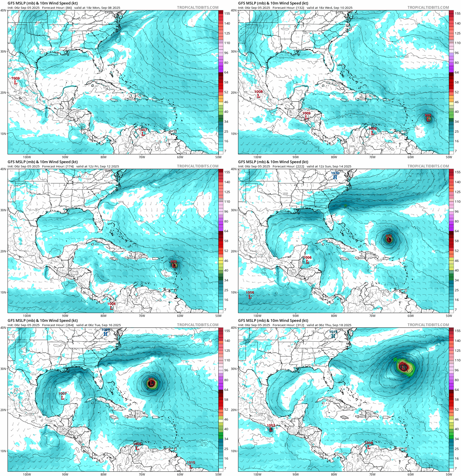
Trend animation focused around Puerto Rico (good luck).
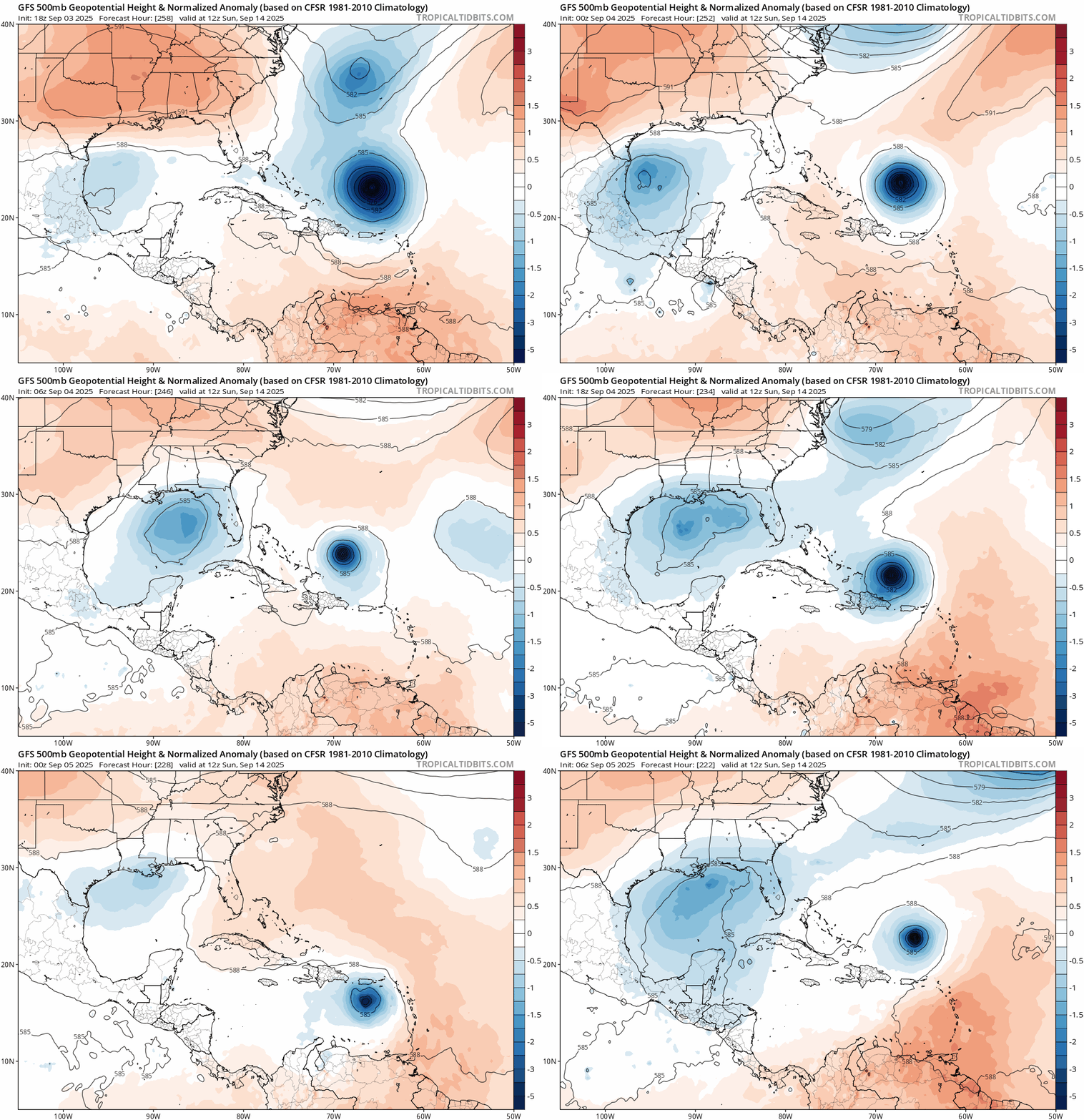

Trend animation focused around Puerto Rico (good luck).

0 likes
-
Stratton23
- Category 5

- Posts: 3574
- Joined: Fri Jul 21, 2023 10:59 pm
- Location: Katy, Tx
Re: ATL: INVEST 91L - Models
And the 06z GEFS shifted south again, with most members ( that do end up developing ) pretty far south in the caribbean, mych different from the OP run lol
0 likes
- Category5Kaiju
- Category 5

- Posts: 4345
- Joined: Thu Dec 24, 2020 12:45 pm
- Location: Seattle during the summer, Phoenix during the winter
Re: ATL: INVEST 91L - Models
It's honestly quite fascinating seeing how the models are trying to get a grasp on 91L. Especially with the operational GFS's highly discrepant runs and with ensemble support going from major hurricanes to barely anything. I really think that this being in the monsoonal trough is making things much more complicated than if it were a clean wave exiting Africa (like Erin).
However, here's what we do know.
- This system is likely going to ride at a fairly low latitude in the MDR, which means islands in the Lesser Antilles should prepare for likely impacts. How bad is still up in the air.
- We're in September, with very warm waters and an upcoming favorable MJO phase. Given climo, it's more likely than not that this system will eventually become something trackable. It also sits at 60/90, so a monkey wrench would have to be thrown in to really have this turn out to be little to nothing.
4 likes
Unless explicitly stated, all information in my posts is based on my own opinions and observations. Tropical storms and hurricanes can be extremely dangerous. Refer to an accredited weather research agency or meteorologist if you need to make serious decisions regarding an approaching storm.
Who is online
Users browsing this forum: No registered users and 76 guests


