EPAC: KIKO - Hurricane - Discussion

Current storms and invests:

Moderators: hurricanetrack, S2k Moderators


The posts in this forum are NOT official forecasts and should not be used as such. They are just the opinion of the poster and may or may not be backed by sound meteorological data. They are NOT endorsed by any professional institution or STORM2K. For official information, please refer to products from the National Hurricane Center and National Weather Service.

Help Support Storm2K
Message
Author
User avatar
StormWeather
Category 1
Category 1
Posts: 345
Joined: Wed Jun 05, 2024 2:34 pm

Re: EPAC: KIKO - Hurricane - Discussion

#221 Postby StormWeather » Sat Sep 06, 2025 9:03 pm

Kingarabian wrote:
StormWeather wrote:
Kingarabian wrote:Might get a new peak here. Looks like we'll get recon just in time.

What’s crazy is that Kiko is on the 26C isotherm exactly and is trying for another Category 4 peak. Let that sink in.

This is also supposed to be another -PDO season but with two CPAC named storms, a July CPAC MH, a EPAC-origin Hurricane north of Hawaii and another MH in the CPAC on the 26C isotherm it has been anything but normal. Let that sink in as well.


More importantly, in a -PMM as well.

The Eastern and Central Pacific have been behaving kind of like an El Niño year of sorts, but with weaker activity.
0 likes   
Just an average cyclone tracker

The posts in this forum are NOT official forecasts and should not be used as such. They are just the opinion of the poster and may or may not be backed by sound meteorological data. They are NOT endorsed by any professional institution or storm2k.org. For official information, please refer to the NHC and NWS products

User avatar
StormWeather
Category 1
Category 1
Posts: 345
Joined: Wed Jun 05, 2024 2:34 pm

Re: EPAC: KIKO - Hurricane - Discussion

#222 Postby StormWeather » Sat Sep 06, 2025 9:05 pm

Kingarabian wrote:
StormWeather wrote:
Kingarabian wrote:Might get a new peak here. Looks like we'll get recon just in time.

What’s crazy is that Kiko is on the 26C isotherm exactly and is trying for another Category 4 peak. Let that sink in.

This is also supposed to be another -PDO season but with two CPAC named storms, a July CPAC MH, a EPAC-origin Hurricane north of Hawaii and another MH in the CPAC on the 26C isotherm it has been anything but normal. Let that sink in as well.


More importantly, in a -PMM as well.

Also the fact that Iona was the first CPAC homebrew storm to reach MH status in July on record, and it did so with a -PDO and -PMM working against it. Only in 2025 I guess, but that’s for another discussion since this thread is on Kiko.
1 likes   
Just an average cyclone tracker

The posts in this forum are NOT official forecasts and should not be used as such. They are just the opinion of the poster and may or may not be backed by sound meteorological data. They are NOT endorsed by any professional institution or storm2k.org. For official information, please refer to the NHC and NWS products

Sciencerocks
Category 5
Category 5
Posts: 9396
Age: 39
Joined: Thu Jul 06, 2017 1:51 am

Re: EPAC: KIKO - Hurricane - Discussion

#223 Postby Sciencerocks » Sat Sep 06, 2025 9:28 pm

Image
1 likes   

User avatar
Hurricane2022
Category 5
Category 5
Posts: 1662
Joined: Tue Aug 23, 2022 11:38 pm
Location: Araçatuba, Brazil

Re: EPAC: KIKO - Hurricane - Discussion

#224 Postby Hurricane2022 » Sat Sep 06, 2025 10:01 pm

This is cinema.
Image
3 likes   
Sorry for the bad English sometimes...!
For reliable and detailed information for any meteorological phenomenon, please consult the National Hurricane Center, Joint Typhoon Warning Center , or your local Meteo Center.

--------

Una cvm Christo, pro Christo, et in Christo. Sit nomen Domini benedictvm.

dexterlabio
Category 5
Category 5
Posts: 3472
Joined: Sat Oct 24, 2009 11:50 pm

Re: EPAC: KIKO - Hurricane - Discussion

#225 Postby dexterlabio » Sat Sep 06, 2025 10:01 pm

To see CPAC overachieving this year may not be too surprising even in a record negative PDO year, if we note that the -PDO signature isn't really a hallmark one this year. PDO has become increasingly negative due to the anomalously warm SSTs off Japan. Perhaps this can be seen as one of the reasons for CPAC being able to sustain MHs one after another.


BULLETIN
Hurricane Kiko Advisory Number 28
NWS Central Pacific Hurricane Center Honolulu HI EP112025
Issued by NWS National Hurricane Center Miami FL
500 PM HST Sat Sep 06 2025

...KIKO RE-STRENGTHENS TO A CATEGORY 4 AS IT MOVES
WEST-NORTHWESTWARD IN THE CENTRAL PACIFIC...


SUMMARY OF 500 PM HST...0300 UTC...INFORMATION
----------------------------------------------
LOCATION...16.5N 142.4W
ABOUT 860 MI...1385 KM ESE OF HILO HAWAII
ABOUT 1065 MI...1715 KM ESE OF HONOLULU HAWAII
MAXIMUM SUSTAINED WINDS...140 MPH...220 KM/H
PRESENT MOVEMENT...WNW OR 295 DEGREES AT 12 MPH...19 KM/H
MINIMUM CENTRAL PRESSURE...946 MB...27.94 INCHES


WATCHES AND WARNINGS
--------------------
There are no coastal watches or warnings in effect.

Interests in the Hawaiian Islands should monitor the progress of
Kiko.


Hurricane Kiko Discussion Number 28
NWS Central Pacific Hurricane Center Honolulu HI EP112025
Issued by NWS National Hurricane Center Miami FL
500 PM HST Sat Sep 06 2025

Kiko's satellite presentation became more impressive during the
afternoon hours, with a well-defined eye surrounded by a large,
symmetric ring of very cold cloud tops. This annular structure has
allowed the hurricane to re-strengthen despite surrounding dry air
and marginal sea surface temperatures as it gradually gains
latitude. Subjective Dvorak Current Intensity estimates have
increased, with HFO at 6.5/127 kt and SAB at 6.0/115 kt. Objective
estimates from UW-CIMSS are also climbing back to as high as 115 kt.
Based on a blend of these data and the satellite appearance, the
initial intensity is set at 120 kt, making Kiko a Category 4
hurricane on the Saffir-Simpson Hurricane Wind Scale once again.

The initial motion is west-northwestward, or 295 degrees at 10 kt.
The cyclone remains steered by the southwestern flank of a mid-level
ridge, while a mid- to upper-level low north of Hawaii is eroding
the ridge’s western extent. This pattern should maintain a
west-northwestward to northwestward track through the weekend. By
early to mid next week (days 3 to 5), as Kiko weakens and becomes
more vertically shallow, the cyclone will be steered more by the
low-level flow, which should induce a gradual turn toward the west
while keeping the center north of the main Hawaiian Islands. The
latest forecast track lies just to the right of the previous NHC
forecast and represents a blend between that solution and the
consensus aids.

Kiko may hold Category 4 strength into the evening, but gradual
weakening is expected to begin overnight, with it likely falling
below major hurricane status by Sunday night. However, its annular
structure introduces some uncertainty regarding the exact rate of
weakening over the next 12–24 hours. Beyond Monday, the combined
effects of increasing mid-level dry air and strengthening
west-southwesterly shear should accelerate the weakening process. By
days 3 to 5, Kiko is forecast to be a much weaker, shallow, and
sheared system as it passes north of the Hawaiian Islands. The
official forecast remains above most of the short-term guidance,
then trends closer to the consensus aids later in the period.

An Air Force Hurricane Hunter aircraft is scheduled to investigate
Kiko later this evening and will provide a better look at Kiko's
intensity and structure.

Key Messages:

1. Kiko is forecast to approach the Hawaiian Islands during the
early to middle portion of next week. While the forecast track
currently calls for Kiko to pass north of the islands, it is still
too soon to determine the exact location or magnitude of potential
impacts from the cyclone's winds or rains. Interests in the
Hawaiian Islands should continue to monitor the progress of this
storm.

2. Swells generated by Kiko are expected to begin reaching the Big
Island and Maui by Sunday. These swells will gradually build and are
forecast to peak along east-facing exposures of the Hawaiian
Islands late Monday through midweek, potentially producing
life-threatening surf and rip currents. Listen for later advisories
and possible warnings from the National Weather Service.


FORECAST POSITIONS AND MAX WINDS

INIT 07/0300Z 16.5N 142.4W 120 KT 140 MPH
12H 07/1200Z 17.2N 143.9W 110 KT 125 MPH
24H 08/0000Z 18.2N 145.9W 95 KT 110 MPH
36H 08/1200Z 19.5N 148.1W 85 KT 100 MPH
48H 09/0000Z 20.8N 150.3W 75 KT 85 MPH
60H 09/1200Z 22.1N 152.5W 65 KT 75 MPH
72H 10/0000Z 23.2N 154.8W 55 KT 65 MPH
96H 11/0000Z 24.8N 159.2W 40 KT 45 MPH
120H 12/0000Z 25.8N 163.5W 30 KT 35 MPH
1 likes   
Personal Forecast Disclaimer:
The posts in this forum are NOT official forecast and should not be used as such. They are just the opinion of the poster and may or may not be backed by sound meteorological data. They are NOT endorsed by any professional institution or storm2k.org. For official information, please refer to the NHC and NWS products.

User avatar
StormWeather
Category 1
Category 1
Posts: 345
Joined: Wed Jun 05, 2024 2:34 pm

Re: EPAC: KIKO - Hurricane - Discussion

#226 Postby StormWeather » Sat Sep 06, 2025 10:08 pm

dexterlabio wrote:To see CPAC overachieving this year may not be too surprising even in a record negative PDO year, if we note that the -PDO signature isn't really a hallmark one this year. PDO has become increasingly negative due to the anomalously warm SSTs off Japan. Perhaps this can be seen as one of the reasons for CPAC being able to sustain MHs one after another.

So wait, a -PDO is warm but a +PDO is cool? Huh?
0 likes   
Just an average cyclone tracker

The posts in this forum are NOT official forecasts and should not be used as such. They are just the opinion of the poster and may or may not be backed by sound meteorological data. They are NOT endorsed by any professional institution or storm2k.org. For official information, please refer to the NHC and NWS products

User avatar
Yellow Evan
Professional-Met
Professional-Met
Posts: 16192
Age: 27
Joined: Fri Jul 15, 2011 12:48 pm
Location: Henderson, Nevada/Honolulu, HI
Contact:

Re: EPAC: KIKO - Hurricane - Discussion

#227 Postby Yellow Evan » Sat Sep 06, 2025 10:16 pm

The PMM has taken on more of a positive look recently, tbf.
0 likes   

User avatar
Hurricane2022
Category 5
Category 5
Posts: 1662
Joined: Tue Aug 23, 2022 11:38 pm
Location: Araçatuba, Brazil

Re: EPAC: KIKO - Hurricane - Discussion

#228 Postby Hurricane2022 » Sat Sep 06, 2025 10:57 pm

1 likes   
Sorry for the bad English sometimes...!
For reliable and detailed information for any meteorological phenomenon, please consult the National Hurricane Center, Joint Typhoon Warning Center , or your local Meteo Center.

--------

Una cvm Christo, pro Christo, et in Christo. Sit nomen Domini benedictvm.

User avatar
xtyphooncyclonex
Category 5
Category 5
Posts: 3864
Age: 23
Joined: Sat Dec 08, 2012 9:07 am
Location: Cebu City
Contact:

Re: EPAC: KIKO - Hurricane - Discussion

#229 Postby xtyphooncyclonex » Sat Sep 06, 2025 11:32 pm

Kiko is a storm that came straight out of the 2015-2018 era. That was peak.

He's pulled off a couple of comebacks already lol
1 likes   
REMINDER: My opinions that I, or any other NON Pro-Met in this forum, are unofficial. Please do not take my opinions as an official forecast and warning. I am NOT a meteorologist. Following my forecasts blindly may lead to false alarm, danger and risk if official forecasts from agencies are ignored.

User avatar
Yellow Evan
Professional-Met
Professional-Met
Posts: 16192
Age: 27
Joined: Fri Jul 15, 2011 12:48 pm
Location: Henderson, Nevada/Honolulu, HI
Contact:

Re: EPAC: KIKO - Hurricane - Discussion

#230 Postby Yellow Evan » Sun Sep 07, 2025 12:31 am

Image

Fading gradually now. I'd wager this was probably 10 maybe 15 knots stronger at peak than whatever recon finds.
1 likes   

User avatar
sasha_B
Tropical Storm
Tropical Storm
Posts: 133
Age: 24
Joined: Sun Jun 30, 2024 4:32 pm
Location: Charleston, SC

Re: EPAC: KIKO - Hurricane - Discussion

#231 Postby sasha_B » Sun Sep 07, 2025 1:28 am

Yellow Evan wrote:https://i.imgur.com/oGuGRe3.gif

Fading gradually now. I'd wager this was probably 10 maybe 15 knots stronger at peak than whatever recon finds.


Looks like recon found 113 kts flight-level winds, though they've yet to sample the northeast quadrant & no eye (or eyewall) dropsonde data has been submitted. I'm inclined to agree with your 'wager' - if there's support for 105~110 kts surface in the area of strongest winds (current readings only really support 95~100), we may have just seen a second 125-kt peak. Presentation has deteriorated in that the CDO has warmed, but the eye remains clear and has yet to show signs of serious disruption.....pressure readings might give a clearer picture of Kiko's current intensity, from which a potential peak would be easier to estimate.
0 likes   

User avatar
cycloneye
Admin
Admin
Posts: 146585
Age: 69
Joined: Thu Oct 10, 2002 10:54 am
Location: San Juan, Puerto Rico

Re: EPAC: KIKO - Hurricane - Discussion

#232 Postby cycloneye » Sun Sep 07, 2025 4:47 am

Hurricane Kiko Discussion Number 29
NWS Central Pacific Hurricane Center Honolulu HI EP112025
Issued by NWS National Hurricane Center Miami FL
1100 PM HST Sat Sep 06 2025

An Air Force Reserve Hurricane Hunter aircraft investigating Kiko
this evening measured a minimum central pressure of 960 mb and
maximum flight-level winds of 113 kt. Although the hurricane
maintains a symmetric annular structure with a well-defined eye, the
surrounding ring of cold cloud tops has warmed over the past few
hours. HFO Dvorak subjective intensity estimates reflected this
weakening trend with a T5.5/102 kt, while SAB had a T5.0/90 kt.
Objective intensity estimates from UW-CIMSS range from 107 to 115
kt. Based on a blend of these data and satellite trends, and
considering the fluctuating intensity that Kiko has exhibited during
the past couple of days, the initial intensity is set at 110 kt,
making Kiko a Category 3 hurricane on the Saffir–Simpson Hurricane
Wind Scale.

The initial motion is west-northwestward, or 300 degrees at 11 kt.
The cyclone remains steered by the southwestern flank of a mid-level
ridge, while a mid- to upper-level low north of Hawaii is eroding
the ridge’s western extent. This pattern should maintain a
west-northwestward to northwestward track through the rest of the
weekend. By early to mid next week (days 3 to 5), as Kiko weakens
and becomes more vertically shallow, the cyclone will be steered
more by the low-level flow, which should induce a gradual turn
toward the west while keeping the center north of the main Hawaiian
Islands. The latest forecast track is nearly identical to the
previous NHC forecast and remains close to the consensus aids.

Kiko has weakened to a Category 3 hurricane this evening, and
additional gradual weakening is expected overnight and into Sunday
as the cyclone remains over cooler waters. It will likely fall below
major hurricane strength by Sunday night. However, its annular
structure introduces some uncertainty regarding the exact rate of
decay over the next 12–24 hours. By Monday, increasing mid-level dry
air and strengthening west-southwesterly shear should lead to a more
pronounced weakening trend. By days 3 to 5, Kiko is forecast to
become a much weaker, shallow, and sheared system as it passes north
of the Hawaiian Islands. The official forecast remains slightly
above most of the short-term guidance, before trending closer to the
consensus aids later in the period.

Another Air Force Hurricane Hunter aircraft is scheduled to
investigate Kiko again around 07/1800 UTC Sunday, which will provide
updated information on its intensity and structure.

Key Messages:

1. Kiko is forecast to approach the Hawaiian Islands during the
early to middle portion of next week. While the forecast track
currently calls for Kiko to pass north of the islands, it is still
too soon to determine the exact location or magnitude of potential
impacts from the cyclone's winds or rains. Interests in the
Hawaiian Islands should continue to monitor the progress of this
storm.

2. Swells generated by Kiko are expected to begin reaching the Big
Island and Maui by Sunday. These swells will gradually build and are
forecast to peak along east-facing exposures of the Hawaiian
Islands late Monday through midweek, potentially producing
life-threatening surf and rip currents. Listen for later advisories
and possible warnings from the National Weather Service.


FORECAST POSITIONS AND MAX WINDS

INIT 07/0900Z 17.1N 143.4W 110 KT 125 MPH
12H 07/1800Z 17.8N 144.9W 100 KT 115 MPH
24H 08/0600Z 18.9N 146.9W 95 KT 110 MPH
36H 08/1800Z 20.2N 149.1W 85 KT 100 MPH
48H 09/0600Z 21.5N 151.4W 75 KT 85 MPH
60H 09/1800Z 22.7N 153.7W 65 KT 75 MPH
72H 10/0600Z 23.6N 155.8W 55 KT 65 MPH
96H 11/0600Z 25.1N 160.2W 40 KT 45 MPH
120H 12/0600Z 26.0N 164.4W 30 KT 35 MPH

$$
Forecaster Gibbs (CPHC)
0 likes   
Visit the Caribbean-Central America Weather Thread where you can find at first post web cams,radars
and observations from Caribbean basin members Click Here

User avatar
Kingarabian
S2K Supporter
S2K Supporter
Posts: 16200
Joined: Sat Aug 08, 2009 3:06 am
Location: Honolulu, Hawaii

Re: EPAC: KIKO - Hurricane - Discussion

#233 Postby Kingarabian » Sun Sep 07, 2025 8:59 am

GEFS had a big shift south. UKMET and CMC showing direct impacts from Kiko but with it likely being a very weak TC.
0 likes   
RIP Kobe Bryant

User avatar
Kingarabian
S2K Supporter
S2K Supporter
Posts: 16200
Joined: Sat Aug 08, 2009 3:06 am
Location: Honolulu, Hawaii

Re: EPAC: KIKO - Hurricane - Discussion

#234 Postby Kingarabian » Sun Sep 07, 2025 11:20 am

:uarrow:
12z Models now all have shifted north.

Image

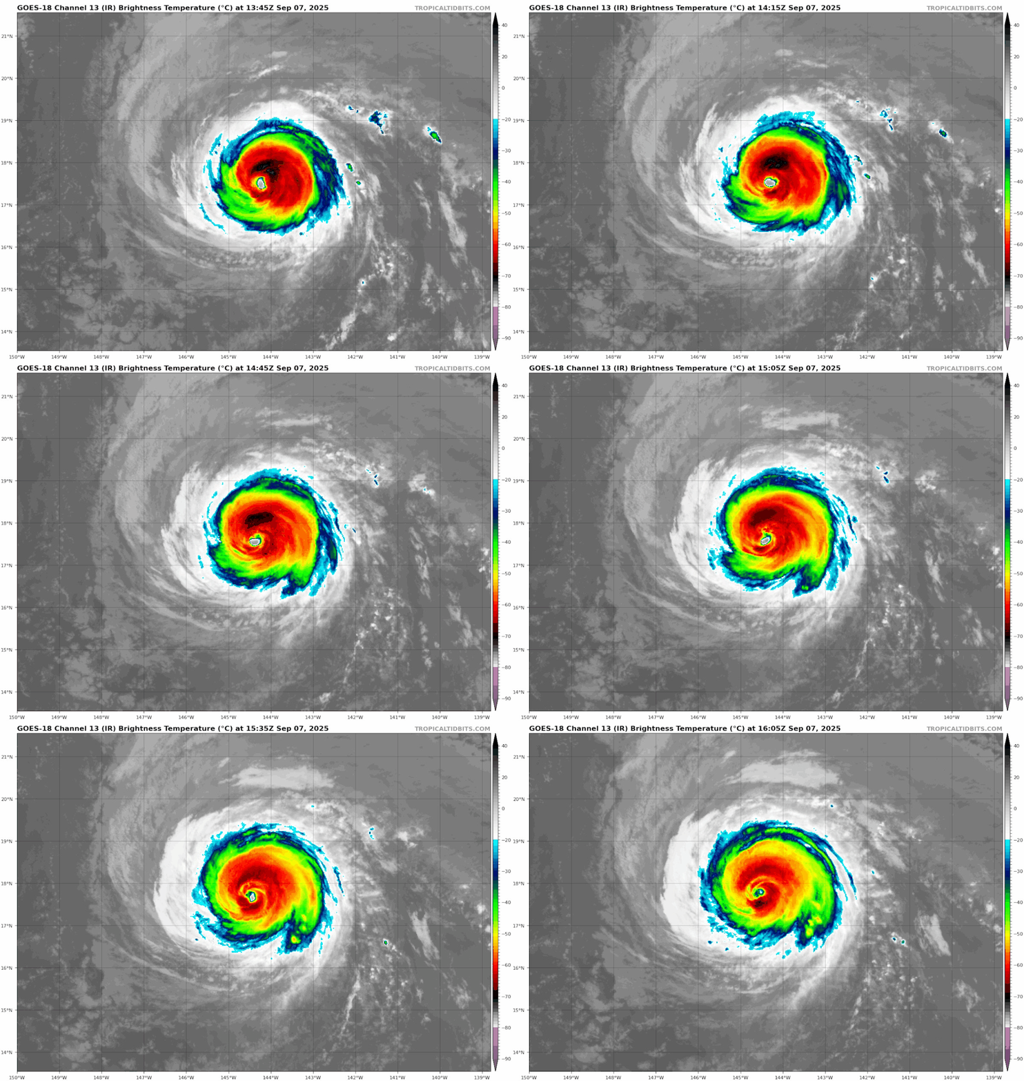
True annular cane.
0 likes   
RIP Kobe Bryant

User avatar
Yellow Evan
Professional-Met
Professional-Met
Posts: 16192
Age: 27
Joined: Fri Jul 15, 2011 12:48 pm
Location: Henderson, Nevada/Honolulu, HI
Contact:

Re: EPAC: KIKO - Hurricane - Discussion

#235 Postby Yellow Evan » Sun Sep 07, 2025 11:39 am

sasha_B wrote:
Yellow Evan wrote:https://i.imgur.com/oGuGRe3.gif

Fading gradually now. I'd wager this was probably 10 maybe 15 knots stronger at peak than whatever recon finds.


Looks like recon found 113 kts flight-level winds, though they've yet to sample the northeast quadrant & no eye (or eyewall) dropsonde data has been submitted. I'm inclined to agree with your 'wager' - if there's support for 105~110 kts surface in the area of strongest winds (current readings only really support 95~100), we may have just seen a second 125-kt peak. Presentation has deteriorated in that the CDO has warmed, but the eye remains clear and has yet to show signs of serious disruption.....pressure readings might give a clearer picture of Kiko's current intensity, from which a potential peak would be easier to estimate.


Recon found 957 mbar at 6z, filling in at 2 mbar/hr. That supports 945 mbar at peak or around 120 knots.
2 likes   

User avatar
cycloneye
Admin
Admin
Posts: 146585
Age: 69
Joined: Thu Oct 10, 2002 10:54 am
Location: San Juan, Puerto Rico

Re: EPAC: KIKO - Hurricane - Discussion

#236 Postby cycloneye » Sun Sep 07, 2025 11:51 am

Hurricane Kiko Discussion Number 30
NWS Central Pacific Hurricane Center Honolulu HI EP112025
Issued by NWS National Hurricane Center Miami FL
500 AM HST Sun Sep 07 2025

Kiko remains a compact hurricane, although the eye has become less
circular during the past few hours. Dvorak CI numbers from SAB,
JTWC, and PHFO now range between 5.5-6.0 (102-115 kt), while
objective numbers from UW-CIMSS are generally between 90-100 kt.
Based on these estimates, the intensity is estimated to be about 100
kt. Another Air Force Reserve Hurricane Hunter aircraft is
scheduled to investigate Kiko around 8 AM HST/1800 UTC.

The hurricane is on a steady west-northwestward trajectory of 300
degrees at 11 kt. A mid-level ridge lies north of Kiko, extending
to about 150W, while a deep-layer low is located north of the
Hawaiian Islands. The steering resulting from this pattern is
expected to keep Kiko on a west-northwestward heading for the next
5 days, with some decrease in speed possible around Friday. Based
on this motion, Kiko is expected to pass to the north of the
Hawaiian Islands on Tuesday and Wednesday, and the most reliable
track models are in good agreement on this scenario. The one main
change in the forecast is that a good chunk of the
guidance is showing a faster motion beyond 48 hours, and the new
NHC forecast is therefore a little faster than the previous
prediction at those forecast times, maintaining a forward speed
of 12-13 kt through day 4.

Kiko is already moving over cool waters of about 25 degrees
Celsius, which is likely causing the current weakening trend.
Although vertical shear is currently low, southwesterly shear of at
least 20 kt is forecast to set in over Kiko in about 24 hours.
Because of the hurricane's small size and it being embedded in a
very dry surrounding environment, this shear is likely to hasten
the weakening trend. The NHC intensity forecast closely follows
the latest HCCA aid, dropping Kiko below hurricane strength just
after 48 hours. While continued weakening is likely thereafter,
there is some uncertainty as to whether Kiko will fall below
tropical storm strength by day 5, as shown in the official
forecast. If model trends continue to show some restrengthening,
then subsequent advisories may keep tropical storm status through 5
days.


Key Messages:

1. Kiko is forecast to pass north of the Hawaiian Islands on
Tuesday and Wednesday. While the risk of direct impacts on
the islands appears to be decreasing, interests there should
continue to monitor Kiko's progress and the latest forecast.

2. Swells generated by Kiko are expected to begin reaching the Big
Island and Maui later today. These swells will gradually build and
are forecast to peak along east-facing exposures of the Hawaiian
Islands late Monday through midweek, potentially producing
life-threatening surf and rip currents. Listen for later advisories
and possible warnings from the National Weather Service.


FORECAST POSITIONS AND MAX WINDS

INIT 07/1500Z 17.6N 144.4W 100 KT 115 MPH
12H 08/0000Z 18.4N 145.9W 95 KT 110 MPH
24H 08/1200Z 19.6N 148.1W 85 KT 100 MPH
36H 09/0000Z 20.9N 150.3W 75 KT 85 MPH
48H 09/1200Z 22.1N 152.7W 65 KT 75 MPH
60H 10/0000Z 23.2N 155.2W 55 KT 65 MPH
72H 10/1200Z 24.2N 157.7W 50 KT 60 MPH
96H 11/1200Z 26.0N 162.4W 40 KT 45 MPH
120H 12/1200Z 27.2N 165.7W 30 KT 35 MPH

$$
Forecaster Berg
0 likes   
Visit the Caribbean-Central America Weather Thread where you can find at first post web cams,radars
and observations from Caribbean basin members Click Here

TomballEd
Category 4
Category 4
Posts: 912
Age: 61
Joined: Wed Aug 16, 2023 4:52 pm
Location: Spring/Klein area, not Tomball

Re: EPAC: KIKO - Hurricane - Discussion

#237 Postby TomballEd » Sun Sep 07, 2025 1:29 pm

I'm not an expert on annular canes, but the word was used, and my understanding was that annular canes resisted cooler water and shear better than non-annular storms.

Kiko has very little deep convection S of the eye now.
2 likes   

User avatar
StormWeather
Category 1
Category 1
Posts: 345
Joined: Wed Jun 05, 2024 2:34 pm

Re: EPAC: KIKO - Hurricane - Discussion

#238 Postby StormWeather » Sun Sep 07, 2025 1:43 pm

A blend of estimates from current recon reports give a raw intensity of 95 kts.

I would go 90 kts, with a pressure of 973 mbs for the 5 pm EST forecast discussion.
Last edited by StormWeather on Sun Sep 07, 2025 3:54 pm, edited 1 time in total.
0 likes   
Just an average cyclone tracker

The posts in this forum are NOT official forecasts and should not be used as such. They are just the opinion of the poster and may or may not be backed by sound meteorological data. They are NOT endorsed by any professional institution or storm2k.org. For official information, please refer to the NHC and NWS products

User avatar
Kingarabian
S2K Supporter
S2K Supporter
Posts: 16200
Joined: Sat Aug 08, 2009 3:06 am
Location: Honolulu, Hawaii

Re: EPAC: KIKO - Hurricane - Discussion

#239 Postby Kingarabian » Sun Sep 07, 2025 1:45 pm

TomballEd wrote:I'm not an expert on annular canes, but the word was used, and my understanding was that annular canes resisted cooler water and shear better than non-annular storms.

Kiko has very little deep convection S of the eye now.


It was used quite a bit. It started to develop annular characteristics about 48 hours. 24 hours ago while it entered its 4th peak and the eye really warmed it showed that it had attained such characteristics as the waters were near 25C and the environment was very dry. But it still had the appearance of a traditional hurricane since it still had dual outflow channels.
Now it has zero banding and looks and is acting as a annular hurricane. Common occurrence in the EPAC. The NHC/CPHC did a really good job in calling for this development to occur well in advance.
3 likes   
RIP Kobe Bryant

User avatar
StormWeather
Category 1
Category 1
Posts: 345
Joined: Wed Jun 05, 2024 2:34 pm

Re: EPAC: KIKO - Hurricane - Discussion

#240 Postby StormWeather » Sun Sep 07, 2025 3:42 pm

Hurricane Kiko Advisory Number 31
NWS Central Pacific Hurricane Center Honolulu HI EP112025
Issued by NWS National Hurricane Center Miami FL
1100 AM HST Sun Sep 07 2025

...AIR FORCE RESERVE HURRICANE HUNTERS FIND THAT KIKO CONTINUES
TO WEAKEN...
...EXPECTED TO PASS NORTH OF THE HAWAIIAN ISLANDS ON TUESDAY AND
WEDNESDAY...


SUMMARY OF 1100 AM HST...2100 UTC...INFORMATION
-----------------------------------------------
LOCATION...18.1N 145.5W
ABOUT 635 MI...1025 KM E OF HILO HAWAII
ABOUT 835 MI...1345 KM ESE OF HONOLULU HAWAII
MAXIMUM SUSTAINED WINDS...110 MPH...175 KM/H
PRESENT MOVEMENT...WNW OR 300 DEGREES AT 13 MPH...20 KM/H
MINIMUM CENTRAL PRESSURE...974 MB...28.77 INCHES


WATCHES AND WARNINGS
--------------------
There are no coastal watches or warnings in effect.

Interests in the Hawaiian Islands should monitor the progress of
Kiko.


DISCUSSION AND OUTLOOK
----------------------
At 1100 AM HST (2100 UTC), the center of Hurricane Kiko was located
near latitude 18.1 North, longitude 145.5 West. Kiko is moving
toward the west-northwest near 13 mph (20 km/h), and this general
motion with a slight increase in forward speed is expected through
Wednesday. On the forecast track, the center of Kiko is expected to
pass north of the Hawaiian Islands on Tuesday and Wednesday.

Reports from an Air Force Reserve Hurricane Hunter aircraft indicate
that maximum sustained winds have decreased to near 110 mph (175
km/h) with higher gusts. Additional weakening is forecast during
the next few days, and Kiko is expected to become a tropical storm
by late Monday or Monday night.

Hurricane-force winds extend outward up to 30 miles (45 km) from the
center and tropical-storm-force winds extend outward up to 80 miles
(130 km).

The minimum central pressure based on dropsonde data is 974 mb
(28.77 inches).


HAZARDS AFFECTING LAND
----------------------
Key messages for Kiko can be found in the Tropical Cyclone
Discussion under AWIPS header HFOTCDCP4 and WMO header WTPA44 PHFO.

SURF: Swells generated by Kiko are expected to begin reaching the
Big Island and Maui today. These swells will gradually build
and are forecast to peak along east-facing exposures of the Hawaiian
Islands late Monday through midweek, potentially producing
life-threatening surf and rip currents. Listen for later advisories
and possible warnings from the National Weather Service.


NEXT ADVISORY
-------------
Next complete advisory at 500 PM HST.

$$
Forecaster Berg
————————————————————————————————————
Hurricane Kiko Discussion Number 31
NWS Central Pacific Hurricane Center Honolulu HI EP112025
Issued by NWS National Hurricane Center Miami FL
1100 AM HST Sun Sep 07 2025


Kiko's eye has become a bit cloud filled during the past few hours,
and cloud-top temperatures around the eye have been gradually
warming. An Air Force Reserve Hurricane Hunter aircraft is
currently investigating the hurricane and measured a 700-mb
flight-level wind of 105 kt in the northeastern quadrant, as well
as a minimum pressure up to 974 mb. Based on the aircraft data,
the current intensity is set at 95 kt, which is also in line with
the latest objective satellite estimates.

The west-northwestward motion of 300/11 kt continues, and a
slightly faster speed on that trajectory is expected at least
through day 4 while Kiko remains on the southwestern periphery of a
mid-level ridge. Based on this motion, Kiko is expected to pass to
the north of the Hawaiian Islands on Tuesday and Wednesday, and the
most reliable track models remain in good agreement on this
scenario. The track guidance is again a little faster with Kiko as
it passes to the north of the islands, and the NHC track forecast
is a bit faster than the previous prediction starting in about 24
hours, but there is no appreciable change in the cross-track
direction. Based on the new forecast, and accounting for typical
forecast errors, there is currently less than a 10 percent chance
of tropical-storm-force winds occurring at any location on the
Hawaiian Islands, and tropical storm watches are not required.

Cool water temperatures appear to be contributing to Kiko's current
weakening. Moderate southwesterly vertical shear is forecast to
develop over Kiko in about 12-18 hours, and that, along with a very
dry surrounding environment, should lead to even quicker weakening.
The new NHC intensity forecast closely follows the HCCA consensus
aids, and shows Kiko falling below hurricane intensity on Monday.
The shear appears to peak in about 48 hours (as much as 30-35 kt),
so if Kiko can survive that period, it's possible that the storm
may weaken more slowly in the latter part of the foreast,
especially with sea surface temperatures along its path expected to
warm to about 27 degrees Celsius by day 3.


Key Messages:

1. Kiko is forecast to pass north of the Hawaiian Islands on Tuesday
and Wednesday. While the risk of direct impacts on the islands
appears to be decreasing, interests there should continue to monitor
Kiko's progress and the latest forecast.

2. Swells generated by Kiko are expected to begin reaching the Big
Island and Maui today. These swells will gradually build and are
forecast to peak along east-facing exposures of the Hawaiian
Islands late Monday through midweek, potentially producing
life-threatening surf and rip currents. Listen for later advisories
and possible warnings from the National Weather Service.


FORECAST POSITIONS AND MAX WINDS

INIT 07/2100Z 18.1N 145.5W 95 KT 110 MPH
12H 08/0600Z 19.0N 147.1W 85 KT 100 MPH
24H 08/1800Z 20.2N 149.3W 70 KT 80 MPH
36H 09/0600Z 21.4N 151.7W 60 KT 70 MPH
48H 09/1800Z 22.6N 154.2W 55 KT 65 MPH
60H 10/0600Z 23.7N 156.9W 50 KT 60 MPH
72H 10/1800Z 24.6N 159.5W 45 KT 50 MPH
96H 11/1800Z 26.6N 163.9W 40 KT 45 MPH
120H 12/1800Z 28.3N 166.6W 35 KT 40 MPH

$$
Forecaster Berg
0 likes   
Just an average cyclone tracker

The posts in this forum are NOT official forecasts and should not be used as such. They are just the opinion of the poster and may or may not be backed by sound meteorological data. They are NOT endorsed by any professional institution or storm2k.org. For official information, please refer to the NHC and NWS products


Return to “Active Storms/Invests - Atlantic/EastPAC/CentralPAC/MED”

Who is online

Users browsing this forum: Majestic-12 [Bot] and 46 guests