Tropical Wave over the Central Caribbean
Moderator: S2k Moderators
Forum rules

The posts in this forum are NOT official forecasts and should not be used as such. They are just the opinion of the poster and may or may not be backed by sound meteorological data. They are NOT endorsed by any professional institution or STORM2K. For official information, please refer to products from the National Hurricane Center and National Weather Service.
-
tropicwatch

- Category 5

- Posts: 3427
- Age: 62
- Joined: Sat Jun 02, 2007 10:01 am
- Location: The Villages, Florida
- Contact:
Re: Tropical Wave SE of the Windward Islands
Starting to see some 925mb vorticity in the area of the latest flare up of convection.
0 likes
Tropicwatch
Agnes 72', Eloise 75, Elena 85', Kate 85', Charley 86', Florence 88', Beryl 94', Dean 95', Erin 95', Opal 95', Earl 98', Georges 98', Ivan 2004', Arlene 2005', Dennis 2005', Ida 2009' Debby 2012' Irma 2017' Michael 2018'
Agnes 72', Eloise 75, Elena 85', Kate 85', Charley 86', Florence 88', Beryl 94', Dean 95', Erin 95', Opal 95', Earl 98', Georges 98', Ivan 2004', Arlene 2005', Dennis 2005', Ida 2009' Debby 2012' Irma 2017' Michael 2018'

Re: Tropical Wave SE of the Windward Islands
0 likes
TC naming lists: retirements and intensity
Most aggressive Advisory #1's in North Atlantic (cr. kevin for starting the list)
Most aggressive Advisory #1's in North Atlantic (cr. kevin for starting the list)
Re: Tropical Wave SE of the Windward Islands
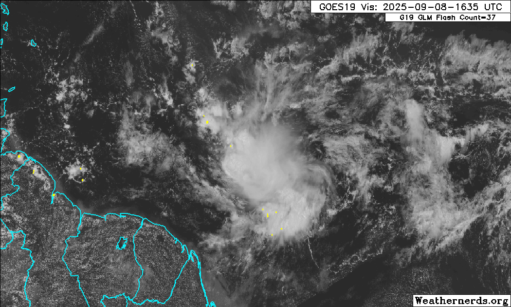
Well, there is some kind of circulation evident on visible satellite imagery. Let’s watch and see. It still has time to avoid SA if it is legitimate 
1 likes


Re: Tropical Wave SE of the Windward Islands
Indeed; some lower level of turning appears at 7.5N and 47W. Sustaining itself or further deepening will be dependant on central convection.
0 likes
Andy D
(For official information, please refer to the NHC and NWS products.)
(For official information, please refer to the NHC and NWS products.)
-
Stratton23
- Category 5
- Posts: 3574
- Joined: Fri Jul 21, 2023 10:59 pm
- Location: Katy, Tx
Re: Tropical Wave SE of the Windward Islands
Interesting to note on the euro/ GFS if you select the 850 MB option, both the euro and gfs show this vigorous disturbance gaining latitude and tracking through the caribbean eventually ending up in the vicinity of the NW caribbean- yucatan peninsula , Euro doesn’t develop but still a weak 850mb signature can be tracked, GFS showing that development in the NW caribbean consistently may have something to do with this tropical wave
2 likes
Re: Tropical Wave SE of the Windward Islands
As of 10:00pm this evening, an increasing defined circulation with strong convection limited to its north quadrant appears to be located near 8N & 48W with an apparent west to WNW motion. I'm skeptical about it being on the surface but it may well be making a go at it. I don't really care what the models are suggesting but I'd project 30/50 - short/long range odds to develop.
1 likes
Andy D
(For official information, please refer to the NHC and NWS products.)
(For official information, please refer to the NHC and NWS products.)
Re: Tropical Wave SE of the Windward Islands
chaser1 wrote:As of 10:00pm this evening, an increasing defined circulation with strong convection limited to its north quadrant appears to be located near 8N & 48W with an apparent west to WNW motion. I'm skeptical about it being on the surface but it may well be making a go at it. I don't really care what the models are suggesting but I'd project 30/50 - short/long range odds to develop.
Hey chaser, Do you think there’s enough Coriolis force way down at 8N to get this to spin up into a TC? I count only 7 TCGs that far S with way more near 10N.
0 likes
Personal Forecast Disclaimer:
The posts in this forum are NOT official forecasts and should not be used as such. They are just the opinion of the poster and may or may not be backed by sound meteorological data. They are NOT endorsed by any professional institution or storm2k.org. For official information, please refer to the NHC and NWS products.
The posts in this forum are NOT official forecasts and should not be used as such. They are just the opinion of the poster and may or may not be backed by sound meteorological data. They are NOT endorsed by any professional institution or storm2k.org. For official information, please refer to the NHC and NWS products.
-
Stratton23
- Category 5
- Posts: 3574
- Joined: Fri Jul 21, 2023 10:59 pm
- Location: Katy, Tx
Re: Tropical Wave SE of the Windward Islands
LarryWx if you look at the 12z euro 850 MB map, despite not developing it does have this wave gaining latitude in the next 2-3 days and actually moving into the caribbean, eventually ends up in the NW caribbean sea near the yucatan peninsula, its possible this could develop if it manages to gain enough latitude in time to avoid SA
1 likes
Re: Tropical Wave SE of the Windward Islands
.LarryWx wrote:chaser1 wrote:As of 10:00pm this evening, an increasing defined circulation with strong convection limited to its north quadrant appears to be located near 8N & 48W with an apparent west to WNW motion. I'm skeptical about it being on the surface but it may well be making a go at it. I don't really care what the models are suggesting but I'd project 30/50 - short/long range odds to develop.
Hey chaser, Do you think there’s enough Coriolis force way down at 8N to get this to spin up into a TC? I count only 7 TCGs that far S with way more near 10N.
Yes I do however..... I'll also admit that the Coriolis force could well be outweighed by the shorter term impact of a strong deep layer flow that within a given region, might still force a tropical cyclone westward. Even more likely would be for this disturbance to still remain entirely shallow, in which case it's motion would remain at the mercy of the low level Easterlies (unless or until a little bit of a vertical structure were to begin to develop).
1 likes
Andy D
(For official information, please refer to the NHC and NWS products.)
(For official information, please refer to the NHC and NWS products.)
Re: Tropical Wave SE of the Windward Islands
Further analysis suggests that a potential center would appear to be under the southeast side of a small but currently expanding CDO. SST's are 29C (and rise to 30C just east of the Southern Windwards and around 10N). Present outflow nicely expands out to the west and north quadrants. The disturbance itself appears to be the leading edge of significantly moist flow environment, with the CDO feature essentially just outside the dry line demarcated by the much dryer air to its west.
It remains to be seen for this disturbance to develope and maintain a singular CDO co-located with an apparent LLC. It could soon go poof following DMAX but it its identity is maintained into tomorrow, then it wouldn't be unreasonable for a TD to develop just east of or while passing through the Windward Islands.
It remains to be seen for this disturbance to develope and maintain a singular CDO co-located with an apparent LLC. It could soon go poof following DMAX but it its identity is maintained into tomorrow, then it wouldn't be unreasonable for a TD to develop just east of or while passing through the Windward Islands.
Last edited by chaser1 on Tue Sep 09, 2025 12:00 am, edited 1 time in total.
1 likes
Andy D
(For official information, please refer to the NHC and NWS products.)
(For official information, please refer to the NHC and NWS products.)
-
Stratton23
- Category 5
- Posts: 3574
- Joined: Fri Jul 21, 2023 10:59 pm
- Location: Katy, Tx
Re: Tropical Wave SE of the Windward Islands
Chaser1 worth watching if it gets into the caribbean, this looks like the wave that the GFS has been consistently developing in the western caribbean, it can be tracked on the 850 mb level
0 likes
Re: Tropical Wave SE of the Windward Islands
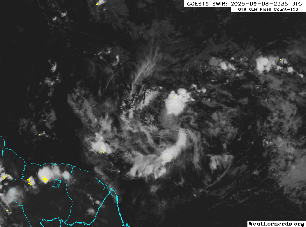
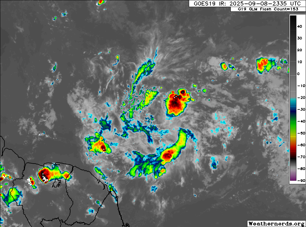
So far tonight, a nice burst of deep convection has sustained itself, even though alignment with the center could be better.
0 likes
TC naming lists: retirements and intensity
Most aggressive Advisory #1's in North Atlantic (cr. kevin for starting the list)
Most aggressive Advisory #1's in North Atlantic (cr. kevin for starting the list)
Re: Tropical Wave SE of the Windward Islands
tropicwatch wrote:Starting to see some 925mb vorticity in the area of the latest flare up of convection.
I'm really having difficulty with the models as a whole. Days ago the GFS was forecasting 91L to develop into a TS but eventually dropped it. Now, it doesn't seem to acknowledge an established tropical disturbance approaching 50W. I can't help but wonder what broke.... bad data, less data collection, data computing issues, or just some new magical meteorological phenomenon impacting our basin (or overall Climate) that science seems challenged to get ahead of and understand?
1 likes
Andy D
(For official information, please refer to the NHC and NWS products.)
(For official information, please refer to the NHC and NWS products.)
Re: Tropical Wave SE of the Windward Islands
Teban54 wrote:So far tonight, a nice burst of deep convection has sustained itself, even though alignment with the center could be better.
[url]https://i.postimg.cc/hjTKqhP3/15559184.gif [/url]
[url]https://i.postimg.cc/brPpY8ZY/15559184-1.gif [/url]
The result of Easterly shear perhaps? I would think that continued convective bursting might overcome light easterly shear. Just the convection part is a big "if" atm.
0 likes
Andy D
(For official information, please refer to the NHC and NWS products.)
(For official information, please refer to the NHC and NWS products.)
Re: Tropical Wave SE of the Windward Islands
Stratton23 wrote:Chaser1 worth watching if it gets into the caribbean, this looks like the wave that the GFS has been consistently developing in the western caribbean, it can be tracked on the 850 mb level
I think you're right. I was suspecting that was the case but had not had the time during the last few days to go back and compare 91L and this disturbance. If the same, and for no other reason then the "attendant" mid level energy to the north of 91L finally being pulled further away, then that alone would seem to better allow a low level feature to possibly develop & deepen.
1 likes
Andy D
(For official information, please refer to the NHC and NWS products.)
(For official information, please refer to the NHC and NWS products.)
-
AJC3

- Admin

- Posts: 4156
- Age: 62
- Joined: Tue Aug 31, 2004 7:04 pm
- Location: Ballston Spa, New York
- Contact:
Re: Tropical Wave SE of the Windward Islands
Stitched MON evening METOP-B and METOP-C ASCAT passes. Looks like the broad, ill-defined center was near 9.5N 46W about 6 hours ago. Roughly 24 hours,ASCAT showed a broad center near 7.9N 40W, so it is gaining latitude, and likely enough to avoid running into SOAM. But we'll see what happens when it enters the accelerating easterlies of the eastern Caribbean "graveyard".

1 likes
Re: Tropical Wave SE of the Windward Islands
chaser1 wrote:Stratton23 wrote:Chaser1 worth watching if it gets into the caribbean, this looks like the wave that the GFS has been consistently developing in the western caribbean, it can be tracked on the 850 mb level
I think you're right. I was suspecting that was the case but had not had the time during the last few days to go back and compare 91L and this disturbance. If the same, and for no other reason then the "attendant" mid level energy to the north of 91L finally being pulled further away, then that alone would seem to better allow a low level feature to possibly develop & deepen.
What’s odd is that the 0Z EPS shows a well defined TC moving WNW toward the northern Leewards (so quite a bit of N component), but from only one member of the 50! The 18Z run has also exactly one member! And the GEFS/GEPS have none.
0 likes
Personal Forecast Disclaimer:
The posts in this forum are NOT official forecasts and should not be used as such. They are just the opinion of the poster and may or may not be backed by sound meteorological data. They are NOT endorsed by any professional institution or storm2k.org. For official information, please refer to the NHC and NWS products.
The posts in this forum are NOT official forecasts and should not be used as such. They are just the opinion of the poster and may or may not be backed by sound meteorological data. They are NOT endorsed by any professional institution or storm2k.org. For official information, please refer to the NHC and NWS products.

Re: Tropical Wave SE of the Windward Islands
Looks like the low-level vorts are not well aligned, with the convection well to the west.
It really needs to start picking up the high TPW air from the Amazon.
Watching.
It really needs to start picking up the high TPW air from the Amazon.
Watching.
1 likes
Re: Tropical Wave SE of the Windward Islands
LarryWx wrote:chaser1 wrote:Stratton23 wrote:Chaser1 worth watching if it gets into the caribbean, this looks like the wave that the GFS has been consistently developing in the western caribbean, it can be tracked on the 850 mb level
I think you're right. I was suspecting that was the case but had not had the time during the last few days to go back and compare 91L and this disturbance. If the same, and for no other reason then the "attendant" mid level energy to the north of 91L finally being pulled further away, then that alone would seem to better allow a low level feature to possibly develop & deepen.
What’s odd is that the 0Z EPS shows a well defined TC moving WNW toward the northern Leewards (so quite a bit of N component), but from only one member of the 50! The 18Z run has also exactly one member! And the GEFS/GEPS have none.
And I can now add the 6Z EPS as having one member with a TC from this. It’s the 3rd EPS run in a row with exactly one member developing a TS+ from this that then goes WNW to NW toward the N Leeward Islands (plenty of N component).
0 likes
Personal Forecast Disclaimer:
The posts in this forum are NOT official forecasts and should not be used as such. They are just the opinion of the poster and may or may not be backed by sound meteorological data. They are NOT endorsed by any professional institution or storm2k.org. For official information, please refer to the NHC and NWS products.
The posts in this forum are NOT official forecasts and should not be used as such. They are just the opinion of the poster and may or may not be backed by sound meteorological data. They are NOT endorsed by any professional institution or storm2k.org. For official information, please refer to the NHC and NWS products.
-
tropicwatch
- Category 5
- Posts: 3427
- Age: 62
- Joined: Sat Jun 02, 2007 10:01 am
- Location: The Villages, Florida
- Contact:
Re: Tropical Wave SE of the Windward Islands
Convection is being persistent and not all over the place.
1 likes
Tropicwatch
Agnes 72', Eloise 75, Elena 85', Kate 85', Charley 86', Florence 88', Beryl 94', Dean 95', Erin 95', Opal 95', Earl 98', Georges 98', Ivan 2004', Arlene 2005', Dennis 2005', Ida 2009' Debby 2012' Irma 2017' Michael 2018'
Agnes 72', Eloise 75, Elena 85', Kate 85', Charley 86', Florence 88', Beryl 94', Dean 95', Erin 95', Opal 95', Earl 98', Georges 98', Ivan 2004', Arlene 2005', Dennis 2005', Ida 2009' Debby 2012' Irma 2017' Michael 2018'
Who is online
Users browsing this forum: AnnularCane and 178 guests