EPAC: MARIO - Remnants - Discussion

Current storms and invests:

Moderators: hurricanetrack, S2k Moderators


The posts in this forum are NOT official forecasts and should not be used as such. They are just the opinion of the poster and may or may not be backed by sound meteorological data. They are NOT endorsed by any professional institution or STORM2K. For official information, please refer to products from the National Hurricane Center and National Weather Service.

Help Support Storm2K
Message
Author
User avatar
cycloneye
Admin
Admin
Posts: 146656
Age: 69
Joined: Thu Oct 10, 2002 10:54 am
Location: San Juan, Puerto Rico

Re: EPAC: THIRTEEN - E - Tropical Depression - Discussion

#21 Postby cycloneye » Thu Sep 11, 2025 9:46 pm

BULLETIN
Tropical Depression Thirteen-E Advisory Number 2
NWS National Hurricane Center Miami FL EP132025
900 PM CST Thu Sep 11 2025

...TROPICAL DEPRESSION THIRTEEN-E HEADING WEST-NORTHWESTWARD OFF THE
COAST OF SOUTHERN MEXICO...


SUMMARY OF 900 PM CST...0300 UTC...INFORMATION
----------------------------------------------
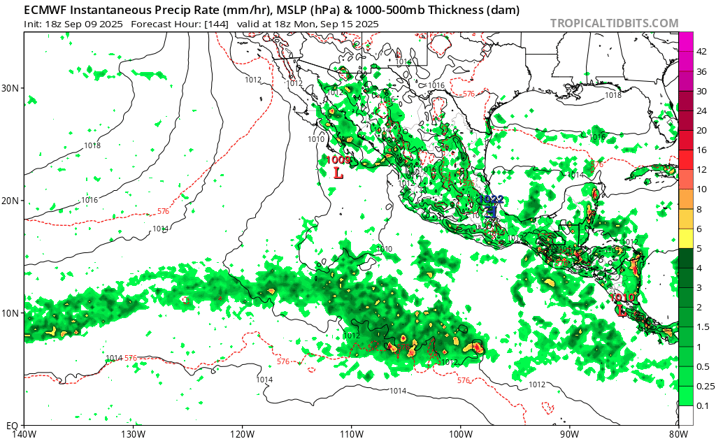
LOCATION...16.0N 99.6W
ABOUT 65 MI...105 KM SSE OF ACAPULCO MEXICO
MAXIMUM SUSTAINED WINDS...35 MPH...55 KM/H
PRESENT MOVEMENT...WNW OR 290 DEGREES AT 12 MPH...19 KM/H
MINIMUM CENTRAL PRESSURE...1007 MB...29.74 INCHES


Tropical Depression Thirteen-E Discussion Number 2
NWS National Hurricane Center Miami FL EP132025
900 PM CST Thu Sep 11 2025

The satellite appearance of Thirteen-E has improved some since the
previous advisory, with deep convection continuing to burst over or
near the estimated low-level center. The latest subjective Dvorak
current intensity estimates from TAFB and SAB were 2.5/35 kt and
2.0/30 kt. Meanwhile the objective estimates from UW-CIMSS have
ranged from 28 to 35 kt since the previous advisory. Based on a
blend of these data, the initial intensity has been held, perhaps
conservatively, at 30 kt for this advisory package.

The depression is moving to the west-northwest, or 290 degrees, at
10 kt. This general motion is expected to continue for the next
couple days, as the cyclone is steered by a mid-level ridge over
northern Mexico and Texas. A turn toward the northwest along with a
decrease in forward speed is expected over the weekend, as the
system moves along the southwestern periphery of the mid-level
ridge, with that motion continuing through day 5. The official
track forecast lies is very close to the previous advisory, roughly
between the corrected consensus HCCA and AI-Driven GDMI track aids.

The circulation of Thirteen-E remains very small, with an estimated
radius of the outermost closed isobar only 80 n mi, and this may be
generous. In the next couple of days, the global models suggest
that moderate northeasterly vertical wind shear, along with the
proximity to land, should limit the system's ability to intensify
significantly, and the intensity forecast only calls for some slow
strengthening. Over the weekend, environmental conditions should
become more favorable for intensification, as the system will be
farther offshore, over very warm water and surrounded by moist
mid-level air, while vertical wind shear will drop off to light
levels and become aligned with the motion of the cyclone. This
should lead to steady strengthening, with the system forecast to
become a hurricane by 72 hours. By day 5, cooler sea surface
temperatures and drier more stable environment should lead to a
weakening trend. The official intensity forecast lies on the higher
end of the intensity guidance envelope and closest to the AI-Driven
GDMI intensity aid.


Key Messages:
1. Heavy rainfall associated with Tropical Depression Thirteen-E
will impact southern and southwestern Mexico through Sunday, which
could result in flash flooding, particularly in areas of higher
terrain.

2. The depression is forecast to become a tropical storm later
tonight, while moving parallel to the southern and southwestern
coasts of Mexico. While the strongest winds are expected to remain
offshore, gusty winds are possible along portions of the southern
and southwestern coast of Mexico from Punta Maldonado through
Manzanillo during the next day or so. Interests in these areas
should monitor the progress of this system.


FORECAST POSITIONS AND MAX WINDS

INIT 12/0300Z 16.0N 99.6W 30 KT 35 MPH
12H 12/1200Z 16.5N 101.3W 35 KT 40 MPH
24H 13/0000Z 17.1N 103.5W 40 KT 45 MPH
36H 13/1200Z 17.6N 105.5W 45 KT 50 MPH
48H 14/0000Z 18.0N 107.1W 50 KT 60 MPH
60H 14/1200Z 18.4N 108.6W 60 KT 70 MPH
72H 15/0000Z 18.9N 109.9W 70 KT 80 MPH
96H 16/0000Z 20.7N 112.6W 70 KT 80 MPH
120H 17/0000Z 23.0N 114.7W 55 KT 65 MPH

$$
Forecaster Jelsema (CPHC)
0 likes   
Visit the Caribbean-Central America Weather Thread where you can find at first post web cams,radars
and observations from Caribbean basin members Click Here

User avatar
cycloneye
Admin
Admin
Posts: 146656
Age: 69
Joined: Thu Oct 10, 2002 10:54 am
Location: San Juan, Puerto Rico

Re: EPAC: THIRTEEN - E - Tropical Depression - Discussion

#22 Postby cycloneye » Fri Sep 12, 2025 3:44 am

BULLETIN
Tropical Depression Thirteen-E Advisory Number 3
NWS National Hurricane Center Miami FL EP132025
300 AM CST Fri Sep 12 2025

...DEPRESSION REMAINS POORLY ORGANIZED OFF THE COAST OF SOUTHWESTERN
MEXICO...


SUMMARY OF 300 AM CST...0900 UTC...INFORMATION
----------------------------------------------
LOCATION...16.5N 100.8W
ABOUT 100 MI...160 KM SSE OF ZIHUATANEJO MEXICO
MAXIMUM SUSTAINED WINDS...35 MPH...55 KM/H
PRESENT MOVEMENT...WNW OR 295 DEGREES AT 12 MPH...19 KM/H
MINIMUM CENTRAL PRESSURE...1007 MB...29.74 INCHES


Tropical Depression Thirteen-E Discussion Number 3
NWS National Hurricane Center Miami FL EP132025
300 AM CST Fri Sep 12 2025

The depression remains poorly organized tonight, with only small
areas of convection bursting to the west of the estimated low-level
center. Recent scatterometer data and surface observations indicate
the circulation remains very small. While believable scatterometer
winds up to about 30 kt were noted offshore in the northern
semicircle of the circulation, observations from the Acapulco
International Airport indicated these winds did not reach the coast
when the system made its closest approach earlier tonight. Since the
overall satellite presentation has slightly worsened since the
earlier scatterometer pass, the initial intensity is held at 30 kt.

The initial motion is west-northwestward (295/10 kt), and the system
should maintain this heading during the next couple of days while
being steered by a mid-level ridge centered over northern Mexico.
Later this weekend through early next week, the system is forecast
to move toward the northwest as it rounds the southwestern portion
of the steering ridge. The NHC track forecast through 60 h has been
nudged slightly northward this cycle, in agreement with the latest
multi-model consensus aids.

In the near term, only modest strengthening is forecast due to the
system's close proximity to land. Some models, including the GFS and
ECMWF, completely lose the circulation later today. But if the
system remains offshore and survives its close passage to the
southwestern coast of Mexico, the environment should become somewhat
more favorable for strengthening with weaker shear conditions over
warm waters. Overall, the intensity guidance trended much lower this
cycle. The updated NHC intensity forecast reflects this trend, but
remains on the high end of the guidance envelope. Future downward
adjustments may be necessary, and it cannot be ruled out that the
system dissipates before the end of the 5-day forecast period.


Key Messages:
1. Heavy rainfall associated with Tropical Depression Thirteen-E
will impact southern and southwestern Mexico through Sunday, which
could result in flash flooding, particularly in areas of higher
terrain.

2. The depression is forecast to become a tropical storm today while
moving parallel to the southwestern coast of Mexico. While the
strongest winds are expected to remain offshore, gusty winds are
possible along portions of the southwestern coast of Mexico from
Acapulco to Manzanillo during the next day or so. Interests in these
areas should monitor the progress of this system.


FORECAST POSITIONS AND MAX WINDS

INIT 12/0900Z 16.5N 100.8W 30 KT 35 MPH
12H 12/1800Z 17.0N 102.5W 35 KT 40 MPH
24H 13/0600Z 17.6N 104.6W 35 KT 40 MPH
36H 13/1800Z 18.1N 106.5W 40 KT 45 MPH
48H 14/0600Z 18.6N 108.1W 45 KT 50 MPH
60H 14/1800Z 19.0N 109.6W 55 KT 65 MPH
72H 15/0600Z 19.5N 110.9W 60 KT 70 MPH
96H 16/0600Z 21.0N 113.0W 60 KT 70 MPH
120H 17/0600Z 23.0N 115.5W 45 KT 50 MPH

$$
Forecaster Reinhart
0 likes   
Visit the Caribbean-Central America Weather Thread where you can find at first post web cams,radars
and observations from Caribbean basin members Click Here

User avatar
Kingarabian
S2K Supporter
S2K Supporter
Posts: 16208
Joined: Sat Aug 08, 2009 3:06 am
Location: Honolulu, Hawaii

Re: EPAC: THIRTEEN - E - Tropical Depression - Discussion

#23 Postby Kingarabian » Fri Sep 12, 2025 7:03 am

Proximity to Mexico really putting a lid on this.
0 likes   
RIP Kobe Bryant

User avatar
cycloneye
Admin
Admin
Posts: 146656
Age: 69
Joined: Thu Oct 10, 2002 10:54 am
Location: San Juan, Puerto Rico

Re: EPAC: THIRTEEN - E - Tropical Depression - Discussion

#24 Postby cycloneye » Fri Sep 12, 2025 9:27 am

EP, 13, 2025091212, , BEST, 0, 170N, 1013W, 35, 1006, TS, 34, NEQ, 0, 0, 0, 20, 1011, 80, 20, 0, 0, E, 0, , 0, 0, MARIO, M,
0 likes   
Visit the Caribbean-Central America Weather Thread where you can find at first post web cams,radars
and observations from Caribbean basin members Click Here

User avatar
StormWeather
Category 1
Category 1
Posts: 356
Joined: Wed Jun 05, 2024 2:34 pm

Re: EPAC: THIRTEEN - E - Tropical Depression - Discussion

#25 Postby StormWeather » Fri Sep 12, 2025 9:41 am

cycloneye wrote:
EP, 13, 2025091212, , BEST, 0, 170N, 1013W, 35, 1006, TS, 34, NEQ, 0, 0, 0, 20, 1011, 80, 20, 0, 0, E, 0, , 0, 0, MARIO, M,

Game start

Let’sa go Mario!
2 likes   
Just an average cyclone tracker

The posts in this forum are NOT official forecasts and should not be used as such. They are just the opinion of the poster and may or may not be backed by sound meteorological data. They are NOT endorsed by any professional institution or storm2k.org. For official information, please refer to the NHC and NWS products

User avatar
StormWeather
Category 1
Category 1
Posts: 356
Joined: Wed Jun 05, 2024 2:34 pm

Re: EPAC: MARIO - Tropical Storm - Discussion

#26 Postby StormWeather » Fri Sep 12, 2025 9:46 am

“Mini Mario”
1 likes   
Just an average cyclone tracker

The posts in this forum are NOT official forecasts and should not be used as such. They are just the opinion of the poster and may or may not be backed by sound meteorological data. They are NOT endorsed by any professional institution or storm2k.org. For official information, please refer to the NHC and NWS products

User avatar
cycloneye
Admin
Admin
Posts: 146656
Age: 69
Joined: Thu Oct 10, 2002 10:54 am
Location: San Juan, Puerto Rico

Re: EPAC: MARIO - Tropical Storm - Discussion

#27 Postby cycloneye » Fri Sep 12, 2025 9:51 am

BULLETIN
Tropical Storm Mario Advisory Number 4
NWS National Hurricane Center Miami FL EP132025
900 AM CST Fri Sep 12 2025

...MINI MARIO FORMS JUST OFF THE COAST OF MEXICO...
...TROPICAL STORM WATCH ISSUED FOR A PORTION OF THE STATE OF
MICHOACAN...


SUMMARY OF 900 AM CST...1500 UTC...INFORMATION
----------------------------------------------
LOCATION...17.2N 101.9W
ABOUT 40 MI...65 KM SSW OF ZIHUATANEJO MEXICO
ABOUT 60 MI...95 KM SSE OF LAZARO CARDENAS MEXICO
MAXIMUM SUSTAINED WINDS...40 MPH...65 KM/H
PRESENT MOVEMENT...WNW OR 295 DEGREES AT 14 MPH...22 KM/H
MINIMUM CENTRAL PRESSURE...1006 MB...29.71 INCHES


Tropical Storm Mario Discussion Number 4
NWS National Hurricane Center Miami FL EP132025
900 AM CST Fri Sep 12 2025

37-GHz AMSR2 data from 0823 UTC did an excellent job showing the
well-defined center of the small tropical cyclone about 20 n mi off
the coast of Guerrero, Mexico. As noted in the previous forecast,
an ASCAT pass from overnight showed maximum winds just over 30 kt.
The convective organization has been increasing since that time,
and the depression has powered up to Tropical Storm Mario with
maximum winds estimated at 35 kt. This is supported by a T2.5/35
kt from TAFB and 35-40 kt objective estimates from ADT, AiDT, and
SATCON.

Model guidance is having a challenging time simulating Mario's
future due to the storm's small size and proximity to Mexico's
coastal topography. Some models, including the ECWMF and many of
the Google DeepMind ensemble members, show the system moving inland
and dissipating today. Assuming Mario stays offshore, it is likely
to contend with moderate shear out of the north or northeast for the
next 36 hours while moving over very warm water temperatures around
30 degrees Celsius. Shear is expected to be low beyond 36 hours,
and some strengthening is therefore shown in the NHC intensity
forecast. Some of the hurricane models continue to show Mario
reaching hurricane strength, but given the large degree of
uncertainty, the NHC forecast leans much closer to the IVCN
consensus at this time. Mario is expected to reach colder waters by
day 5, and transition to a post-tropical cyclone is shown at that
time.

Mario has been moving faster toward the west-northwest (295/12 kt),
moving roughly parallel to the coast of Mexico. A mid-level ridge
extending across northern Mexico westward over the Pacific waters
is expected to keep Mario on a west-northwestward trajectory, but
at a slower speed, for at least the next 4 days. The models that
maintain Mario's identity agree on this scenario, and no
significant changes were made to the NHC track forecast.

Given Mario's very close proximity to the coast of Mexico, the
government of Mexico has issued a Tropical Storm Watch for a small
segment of the coast from Lazaro Cardenas to Punta San Telmo.


Key Messages:
1. Heavy rainfall associated with Tropical Storm Mario will impact
southern Mexico through Sunday, which could result in flash
flooding, particularly in areas of higher terrain.

2. Tropical storm conditions are possible along portions of the
coast of Michoacan today while Mario moves roughly parallel to the
southwestern coast of Mexico. Gusty winds are possible elsewhere
along the coasts of western Guerrero, Michoacan, and Colima through
tonight. Interests in these areas should continue to monitor the
progress of Mario.


FORECAST POSITIONS AND MAX WINDS

INIT 12/1500Z 17.2N 101.9W 35 KT 40 MPH
12H 13/0000Z 17.7N 103.7W 35 KT 40 MPH
24H 13/1200Z 18.2N 105.5W 35 KT 40 MPH
36H 14/0000Z 18.7N 107.1W 40 KT 45 MPH
48H 14/1200Z 19.1N 108.5W 45 KT 50 MPH
60H 15/0000Z 19.5N 110.0W 50 KT 60 MPH
72H 15/1200Z 20.1N 111.4W 55 KT 65 MPH
96H 16/1200Z 21.7N 114.2W 40 KT 45 MPH
120H 17/1200Z 23.5N 117.2W 35 KT 40 MPH...POST-TROPICAL

$$
Forecaster Berg
1 likes   
Visit the Caribbean-Central America Weather Thread where you can find at first post web cams,radars
and observations from Caribbean basin members Click Here

Sciencerocks
Category 5
Category 5
Posts: 9399
Age: 39
Joined: Thu Jul 06, 2017 1:51 am

Re: EPAC: MARIO - Tropical Storm - Discussion

#28 Postby Sciencerocks » Fri Sep 12, 2025 10:09 am

Image
0 likes   

User avatar
cycloneye
Admin
Admin
Posts: 146656
Age: 69
Joined: Thu Oct 10, 2002 10:54 am
Location: San Juan, Puerto Rico

Re: EPAC: MARIO - Tropical Storm - Discussion

#29 Postby cycloneye » Fri Sep 12, 2025 1:24 pm

BULLETIN
Tropical Storm Mario Intermediate Advisory Number 4A
NWS National Hurricane Center Miami FL EP132025
1200 PM CST Fri Sep 12 2025

...TROPICAL STORM WATCH IN EFFECT FOR A PORTION OF THE STATE OF
MICHOACAN...


SUMMARY OF 1200 PM CST...1800 UTC...INFORMATION
-----------------------------------------------
LOCATION...17.4N 102.8W
ABOUT 80 MI...130 KM WSW OF ZIHUATANEJO MEXICO
ABOUT 55 MI...90 KM SW OF LAZARO CARDENAS MEXICO
MAXIMUM SUSTAINED WINDS...40 MPH...65 KM/H
PRESENT MOVEMENT...WNW OR 295 DEGREES AT 14 MPH...22 KM/H
MINIMUM CENTRAL PRESSURE...1006 MB...29.71 INCHES
0 likes   
Visit the Caribbean-Central America Weather Thread where you can find at first post web cams,radars
and observations from Caribbean basin members Click Here

User avatar
cycloneye
Admin
Admin
Posts: 146656
Age: 69
Joined: Thu Oct 10, 2002 10:54 am
Location: San Juan, Puerto Rico

Re: EPAC: MARIO - Tropical Storm - Discussion

#30 Postby cycloneye » Fri Sep 12, 2025 3:40 pm

BULLETIN
Tropical Storm Mario Advisory Number 5
NWS National Hurricane Center Miami FL EP132025
300 PM CST Fri Sep 12 2025

...TINY TROPICAL STORM NEAR THE COAST OF SOUTHWESTERN MEXICO...


SUMMARY OF 300 PM CST...2100 UTC...INFORMATION
----------------------------------------------
LOCATION...17.4N 102.9W
ABOUT 90 MI...140 KM WSW OF ZIHUATANEJO MEXICO
ABOUT 60 MI...100 KM SW OF LAZARO CARDENAS MEXICO
MAXIMUM SUSTAINED WINDS...40 MPH...65 KM/H
PRESENT MOVEMENT...WNW OR 290 DEGREES AT 14 MPH...22 KM/H
MINIMUM CENTRAL PRESSURE...1006 MB...29.71 INCHES


Tropical Storm Mario Discussion Number 5
NWS National Hurricane Center Miami FL EP132025
300 PM CST Fri Sep 12 2025

Mario continues to parallel the coast of southwestern Mexico. An
afternoon scatterometer pass showed that Mario is still located just
off the coast, with deep convection periodically forming near the
low-level center and being sheared off to the west. Peak wind
vectors from the ASCAT pass were only 25 kt, however, the instrument
is likely unable to resolve Mario's peak winds due to the small size
of the storm. The initial intensity is held at 35 kt, closest to
the TAFB Dvorak estimate of T2.5.

Numerical models are still struggling to forecast Mario due to the
storm's tiny circulation and proximity to the Mexican coastline.
The European global model, Google DeepMind, and their ensembles
generally show the system either moving inland or opening into a
trough just offshore later today. Of the systems that maintain
Mario for longer into the forecast period, the intensity guidance
envelope has trended downward this cycle. Moderate vertical wind
shear is expected to plague the system for the next day or so, which
should limit any strengthening. If Mario can survive this stage,
the environmental conditions are forecast to briefly become more
conducive for some gradual intensification early next week. By the
end of the forecast period, cool sea surface temperatures and
increasing shear should quickly weaken and dissipate the small
system. Based on the latest guidance, the NHC intensity forecast
now shows Mario becoming a post-tropical cyclone by day 4 and
dissipating by day 5.

Mario continues to move west-northwestward at an estimated 12 kt,
moving roughly parallel to the coast of Mexico. A mid-level ridge
to the north is expected to keep Mario on a west-northwestward
trajectory, but at a slower forward motion, through the end of the
forecast period. The models that maintain Mario's circulation are
general well clustered, and only minor adjustments were made to the
NHC track forecast.

Given Mario's very close proximity to the coast of Mexico, there is
a Tropical Storm Watch in effect for a small segment of the coast
from Lazaro Cardenas to Punta San Telmo.


Key Messages:
1. Heavy rainfall associated with Tropical Storm Mario will impact
Jalisco and nearby areas into Saturday morning, which could result
in flash flooding, particularly in areas of higher terrain.

2. Tropical storm conditions are possible along portions of the
coast of Michoacan today while Mario moves roughly parallel to the
southwestern coast of Mexico. Gusty winds are possible elsewhere
along the coasts of western Guerrero, Michoacan, and Colima through
tonight. Interests in these areas should continue to monitor the
progress of Mario.


FORECAST POSITIONS AND MAX WINDS

INIT 12/2100Z 17.4N 102.9W 35 KT 40 MPH
12H 13/0600Z 17.8N 104.4W 35 KT 40 MPH
24H 13/1800Z 18.5N 106.1W 35 KT 40 MPH
36H 14/0600Z 19.0N 107.4W 40 KT 45 MPH
48H 14/1800Z 19.5N 109.0W 45 KT 50 MPH
60H 15/0600Z 19.9N 110.3W 50 KT 60 MPH
72H 15/1800Z 20.3N 111.8W 50 KT 60 MPH
96H 16/1800Z 21.3N 114.5W 35 KT 40 MPH...POST-TROPICAL
120H 17/1800Z...DISSIPATED

$$
Forecaster Bucci
0 likes   
Visit the Caribbean-Central America Weather Thread where you can find at first post web cams,radars
and observations from Caribbean basin members Click Here

Sciencerocks
Category 5
Category 5
Posts: 9399
Age: 39
Joined: Thu Jul 06, 2017 1:51 am

Re: EPAC: MARIO - Tropical Storm - Discussion

#31 Postby Sciencerocks » Fri Sep 12, 2025 5:29 pm

Image
0 likes   

User avatar
cycloneye
Admin
Admin
Posts: 146656
Age: 69
Joined: Thu Oct 10, 2002 10:54 am
Location: San Juan, Puerto Rico

Re: EPAC: MARIO - Tropical Depression - Discussion

#32 Postby cycloneye » Fri Sep 12, 2025 9:36 pm

BULLETIN
Tropical Depression Mario Advisory Number 6
NWS National Hurricane Center Miami FL EP132025
900 PM CST Fri Sep 12 2025

...MARIO WEAKENS TO A TROPICAL DEPRESSION AS IT STARTS MOVING
AWAY FROM SOUTHWESTERN MEXICO...
...TROPICAL STORM WATCH DISCONTINUED FOR THE COAST OF MEXICO...


SUMMARY OF 900 PM CST...0300 UTC...INFORMATION
----------------------------------------------
LOCATION...18.1N 104.6W
ABOUT 65 MI...105 KM SSW OF MANZANILLO MEXICO
ABOUT 175 MI...280 KM SSE OF CABO CORRIENTES MEXICO
MAXIMUM SUSTAINED WINDS...35 MPH...55 KM/H
PRESENT MOVEMENT...WNW OR 290 DEGREES AT 15 MPH...24 KM/H
MINIMUM CENTRAL PRESSURE...1007 MB...29.74 INCHES


Tropical Depression Mario Discussion Number 6
NWS National Hurricane Center Miami FL EP132025
900 PM CST Fri Sep 12 2025

The low-level center of Mario was apparent this afternoon near the
convective mass just off of the coast of southwestern Mexico. Since
that time, satellite imagery shows that a large low-pressure area is
developing to the south of Mario, with vorticity centers noted near
17N 106W and 15N 103W. This is causing the small circulation of
Mario to lose its identity as it seems to be becoming a part of the
larger circulation. In addition, the convection near the center has
decreased during the past several hours, and there has been a
corresponding decrease in satellite intensity estimates. Based on
these developments, Mario is downgraded to a tropical depression
with an initial intensity of 30 kt.

The dynamical models show several possible scenarios for the
evolution of Mario during the next few days. The ECMWF and Canadian
models show the system dissipating as it becomes absorbed into the
larger low during the next day or two. The UKMET does not absorb
Mario into the low, but shows it degenerating into a trough and
moving northwestward and then westward around the north side of the
low. The GFS, in contrast, uses the Mario circulation to become the
center of the larger low, although it keeps the winds below 35 kt
through the forecast period. The regional hurricane models show the
possibility of a tropical storm re-forming near or west of Socorro
Island in a few days, although it is unclear whether this
development is related to the current Mario circulation. Given
these scenarios, the current trends, and the previous forecast, the
new intensity forecast calls for Mario to continue as a depression
for 36 h before dissipating inside the larger low. However, an
alternative scenario is that the circulation could degenerate to a
trough at any time.

The initial motion is 290/13. If Mario manages to maintain its
identity, it should turn more westward during the next 36 h as it
moves around the north side of the larger low.


Key Messages:
1. Heavy rainfall associated with Mario will impact Jalisco and
nearby areas into Saturday morning, which could result in flash
flooding, particularly in areas of higher terrain.

2. While all coastal watches have been discontinued for Mexico,
gusty winds are possible elsewhere along the coasts of western
Guerrero, Michoacan, and Colima through tonight. Interests in
these areas should continue to monitor the progress of Mario.


FORECAST POSITIONS AND MAX WINDS

INIT 13/0300Z 18.1N 104.6W 30 KT 35 MPH
12H 13/1200Z 18.8N 106.3W 30 KT 35 MPH
24H 14/0000Z 19.2N 108.0W 30 KT 35 MPH
36H 14/1200Z 19.7N 109.7W 30 KT 35 MPH
48H 15/0000Z...DISSIPATED

$$
Forecaster Beven
0 likes   
Visit the Caribbean-Central America Weather Thread where you can find at first post web cams,radars
and observations from Caribbean basin members Click Here

User avatar
DorkyMcDorkface
Category 4
Category 4
Posts: 927
Age: 27
Joined: Mon Sep 30, 2019 1:32 pm
Location: Mid-Atlantic

Re: EPAC: MARIO - Tropical Depression - Discussion

#33 Postby DorkyMcDorkface » Fri Sep 12, 2025 9:57 pm

cycloneye wrote:
BULLETIN
Tropical Depression Mario Advisory Number 6
NWS National Hurricane Center Miami FL EP132025
900 PM CST Fri Sep 12 2025

...MARIO WEAKENS TO A TROPICAL DEPRESSION AS IT STARTS MOVING
AWAY FROM SOUTHWESTERN MEXICO...
...TROPICAL STORM WATCH DISCONTINUED FOR THE COAST OF MEXICO...


SUMMARY OF 900 PM CST...0300 UTC...INFORMATION
----------------------------------------------
LOCATION...18.1N 104.6W
ABOUT 65 MI...105 KM SSW OF MANZANILLO MEXICO
ABOUT 175 MI...280 KM SSE OF CABO CORRIENTES MEXICO
MAXIMUM SUSTAINED WINDS...35 MPH...55 KM/H
PRESENT MOVEMENT...WNW OR 290 DEGREES AT 15 MPH...24 KM/H
MINIMUM CENTRAL PRESSURE...1007 MB...29.74 INCHES


Tropical Depression Mario Discussion Number 6
NWS National Hurricane Center Miami FL EP132025
900 PM CST Fri Sep 12 2025

The low-level center of Mario was apparent this afternoon near the
convective mass just off of the coast of southwestern Mexico. Since
that time, satellite imagery shows that a large low-pressure area is
developing to the south of Mario, with vorticity centers noted near
17N 106W and 15N 103W. This is causing the small circulation of
Mario to lose its identity as it seems to be becoming a part of the
larger circulation. In addition, the convection near the center has
decreased during the past several hours, and there has been a
corresponding decrease in satellite intensity estimates. Based on
these developments, Mario is downgraded to a tropical depression
with an initial intensity of 30 kt.

The dynamical models show several possible scenarios for the
evolution of Mario during the next few days. The ECMWF and Canadian
models show the system dissipating as it becomes absorbed into the
larger low during the next day or two. The UKMET does not absorb
Mario into the low, but shows it degenerating into a trough and
moving northwestward and then westward around the north side of the
low. The GFS, in contrast, uses the Mario circulation to become the
center of the larger low, although it keeps the winds below 35 kt
through the forecast period. The regional hurricane models show the
possibility of a tropical storm re-forming near or west of Socorro
Island in a few days, although it is unclear whether this
development is related to the current Mario circulation. Given
these scenarios, the current trends, and the previous forecast, the
new intensity forecast calls for Mario to continue as a depression
for 36 h before dissipating inside the larger low. However, an
alternative scenario is that the circulation could degenerate to a
trough at any time.

The initial motion is 290/13. If Mario manages to maintain its
identity, it should turn more westward during the next 36 h as it
moves around the north side of the larger low.


Key Messages:
1. Heavy rainfall associated with Mario will impact Jalisco and
nearby areas into Saturday morning, which could result in flash
flooding, particularly in areas of higher terrain.

2. While all coastal watches have been discontinued for Mexico,
gusty winds are possible elsewhere along the coasts of western
Guerrero, Michoacan, and Colima through tonight. Interests in
these areas should continue to monitor the progress of Mario.


FORECAST POSITIONS AND MAX WINDS

INIT 13/0300Z 18.1N 104.6W 30 KT 35 MPH
12H 13/1200Z 18.8N 106.3W 30 KT 35 MPH
24H 14/0000Z 19.2N 108.0W 30 KT 35 MPH
36H 14/1200Z 19.7N 109.7W 30 KT 35 MPH
48H 15/0000Z...DISSIPATED

$$
Forecaster Beven


Mario could use a mushroom right about now :lol:
2 likes   
Please note the thougths expressed by this account are solely those of the user and are from a hobbyist perspective. For more comprehensive analysis, consult an actual professional meteorologist or meteorology agency.


Floyd 1999 | Isabel 2003 | Hanna 2008 | Irene 2011 | Sandy 2012 | Isaias 2020

MarioProtVI
Category 4
Category 4
Posts: 968
Age: 24
Joined: Sun Sep 29, 2019 7:33 pm
Location: New Jersey

Re: EPAC: MARIO - Tropical Depression - Discussion

#34 Postby MarioProtVI » Fri Sep 12, 2025 9:59 pm

So my own self Mario just seems to be the EPac’s version of 91L from last week. Actually abysmal for the NHem for September.
2 likes   

User avatar
Category5Kaiju
Category 5
Category 5
Posts: 4192
Joined: Thu Dec 24, 2020 12:45 pm
Location: Seattle

Re: EPAC: MARIO - Tropical Depression - Discussion

#35 Postby Category5Kaiju » Fri Sep 12, 2025 10:03 pm

And here I was, watching previous model runs turning this into a formidable hurricane. :lol:

Image
5 likes   
Unless explicitly stated, all info in my posts is based on my own opinions and observations. Tropical storms and hurricanes can be extremely dangerous. Do not think you can beat Mother Nature. Refer to an accredited weather research agency or meteorologist if you need to make serious decisions regarding an approaching storm.

User avatar
Teban54
Category 5
Category 5
Posts: 3336
Joined: Sat May 19, 2018 1:19 pm

Re: EPAC: MARIO - Tropical Depression - Discussion

#36 Postby Teban54 » Fri Sep 12, 2025 10:18 pm

This forecast time, 18z 9/15, was when NHC's advisory #1 expected Mario to peak at 70 kts. Euro's trend:

Image

The MH runs were from a mere 3 days ago.

Here's GFS:

Image
0 likes   

MarioProtVI
Category 4
Category 4
Posts: 968
Age: 24
Joined: Sun Sep 29, 2019 7:33 pm
Location: New Jersey

Re: EPAC: MARIO - Tropical Depression - Discussion

#37 Postby MarioProtVI » Sat Sep 13, 2025 12:40 am

Aaaaand this thing already game over’ed.
0 likes   

User avatar
cycloneye
Admin
Admin
Posts: 146656
Age: 69
Joined: Thu Oct 10, 2002 10:54 am
Location: San Juan, Puerto Rico

Re: EPAC: MARIO - Remnants - Discussion

#38 Postby cycloneye » Sat Sep 13, 2025 12:48 am

Wow, that was a very rapid demise.

Remnants of Mario Tropical Cyclone Update
NWS National Hurricane Center Miami FL EP132025
1130 PM CST Fri Sep 12 2025

...MARIO IS NO LONGER A TROPICAL CYCLONE...
...LAST ADVISORY WILL BE ISSUED SHORTLY...

Recent satellite-derived wind data and satellite imagery indicate
that Mario no longer has a well-defined center of circulation.
Therefore, a special, final, advisory will be issued by 1200 AM
CST...0600 UTC, in lieu of the 0900 UTC advisory.

SUMMARY OF 1130 PM CST...0530 UTC...INFORMATION
----------------------------------------------
LOCATION...18.3N 105.3W
ABOUT 85 MI...135 KM SW OF MANZANILLO MEXICO
MAXIMUM SUSTAINED WINDS...30 MPH...50 KM/H
PRESENT MOVEMENT...WNW OR 290 DEGREES AT 15 MPH...24 KM/H
MINIMUM CENTRAL PRESSURE...1009 MB...29.79 INCHES

$$
Forecaster Reinhart
0 likes   
Visit the Caribbean-Central America Weather Thread where you can find at first post web cams,radars
and observations from Caribbean basin members Click Here

CrazyC83
Professional-Met
Professional-Met
Posts: 34102
Joined: Tue Mar 07, 2006 11:57 pm
Location: Deep South, for the first time!

Re: EPAC: MARIO - Remnants - Discussion

#39 Postby CrazyC83 » Sat Sep 13, 2025 1:36 am

So laughable, even a Goomba could wipe it clean.
0 likes   

al78
Professional-Met
Professional-Met
Posts: 340
Joined: Thu Nov 01, 2018 12:20 pm

Re: EPAC: MARIO - Tropical Depression - Discussion

#40 Postby al78 » Sat Sep 13, 2025 2:57 am

MarioProtVI wrote:So my own self Mario just seems to be the EPac’s version of 91L from last week. Actually abysmal for the NHem for September.


Unlike 91L, it managed to get as far as developing into a tropical storm.

What is going on with the northern hemisphere this year? Something is putting a lid on tropical cyclogenesis on a hemispheric scale. Normally, there is at least one basin that is active at this time of year.
3 likes   


Return to “Active Storms/Invests - Atlantic/EastPAC/CentralPAC/MED”

Who is online

Users browsing this forum: No registered users and 40 guests