07L GABRIELLE 250922 0600 29.7N 62.4W ATL 75 981
NATL: GABRIELLE - Post-Tropical - Discussion
Moderator: S2k Moderators
-
ElectricStorm

- Category 5

- Posts: 5152
- Age: 25
- Joined: Tue Aug 13, 2019 11:23 pm
- Location: Norman, OK
Re: NATL: GABRIELLE - Hurricane - Discussion
2 likes
B.S Meteorology, University of Oklahoma '25
Please refer to the NHC, NWS, or SPC for official information.
Please refer to the NHC, NWS, or SPC for official information.

Re: NATL: GABRIELLE - Hurricane - Discussion
cheezyWXguy wrote:So Gabrielle finally woke up. With no significant impacts to land in the immediate forecast, I’m glad to see it.
Not necessarily. The westernmost islands of the Azores may experience sustained tropical-storm-force winds (possibly gusting to hurricane force) early on Friday morning—local time. When I asked Google AI Does the National Hurricane Center provide forecast guidance for the Azores?, it/he/she (

2 likes
-
MEANINGLESS_NUMBERS
- Category 2

- Posts: 503
- Joined: Mon Nov 02, 2020 1:43 pm
Re: NATL: GABRIELLE - Hurricane - Discussion
Great images of the eye from Bermuda radar: 
3 likes
Emily '87, Felix '95, Gert '99, Fabian '03, Humberto '19, Paulette '20, Teddy '20, Fiona '22, Lee '23, Ernesto '24, Humberto/Imelda '25

Re: NATL: GABRIELLE - Hurricane - Discussion
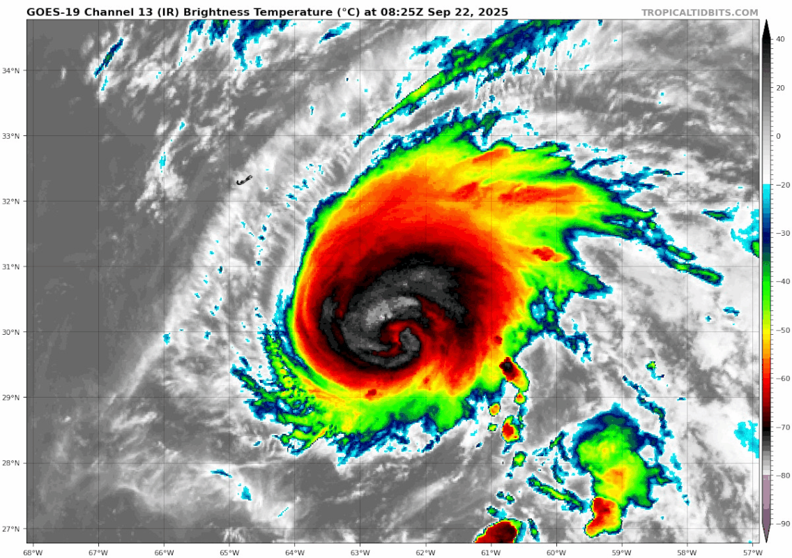
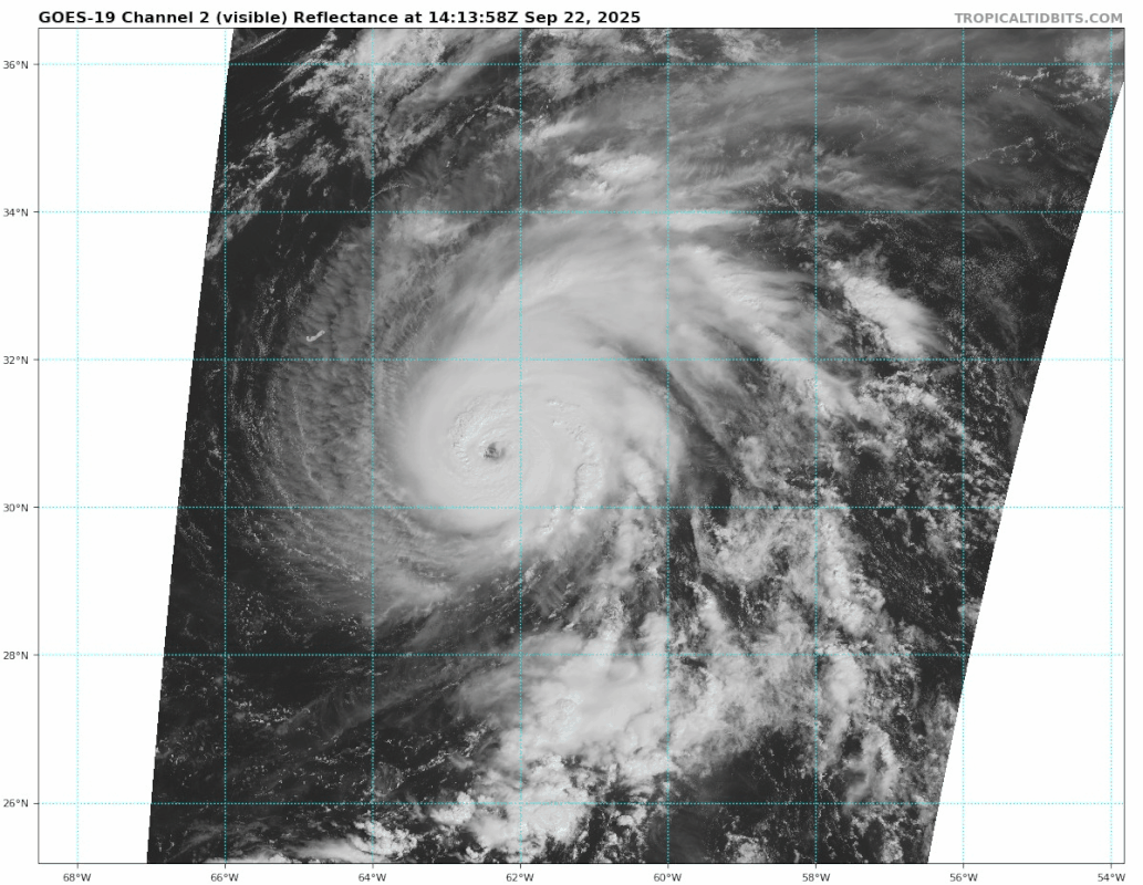
Eye clearing out better on IR and VIS, raw T# shoot up to 5.8. CDO temperature has fallen to -68C. Could be a MH within 12 hours imo.

1 likes

Re: NATL: GABRIELLE - Hurricane - Discussion
80 kts you say?

3 likes
Igor 2010, Sandy 2012, Fay 2014, Gonzalo 2014, Joaquin 2015, Nicole 2016, Humberto 2019, Imelda 2025
I am only a tropical weather enthusiast. My predictions are not official and may or may not be backed by sound meteorological data. For official information, please refer to the NHC and NWS products.
I am only a tropical weather enthusiast. My predictions are not official and may or may not be backed by sound meteorological data. For official information, please refer to the NHC and NWS products.
-
MEANINGLESS_NUMBERS
- Category 2
- Posts: 503
- Joined: Mon Nov 02, 2020 1:43 pm
Re: NATL: GABRIELLE - Hurricane - Discussion
Radar appearance continues to improve through the morning. I think we could see Cat 3 at the next update:

0 likes
Emily '87, Felix '95, Gert '99, Fabian '03, Humberto '19, Paulette '20, Teddy '20, Fiona '22, Lee '23, Ernesto '24, Humberto/Imelda '25
Re: NATL: GABRIELLE - Hurricane - Discussion
Hmm I retract my previous statement, Gabrielle might already be around MH intensity, raw T# up to a very impressive 6.2.


0 likes
-
MEANINGLESS_NUMBERS
- Category 2
- Posts: 503
- Joined: Mon Nov 02, 2020 1:43 pm
Re: NATL: GABRIELLE - Hurricane - Discussion
Bermuda having the luckiest season so far. Majors on both sides. 
0 likes
Emily '87, Felix '95, Gert '99, Fabian '03, Humberto '19, Paulette '20, Teddy '20, Fiona '22, Lee '23, Ernesto '24, Humberto/Imelda '25
Re: NATL: GABRIELLE - Hurricane - Discussion
...GABRIELLE RAPIDLY INTENSIFIES INTO A MAJOR HURRICANE SOUTHEAST OF BERMUDA...
4 likes
-
MarioProtVI
- Category 5
- Posts: 1038
- Age: 24
- Joined: Sun Sep 29, 2019 7:33 pm
- Location: New Jersey
Re: NATL: GABRIELLE - Hurricane - Discussion
...GABRIELLE RAPIDLY INTENSIFIES INTO A MAJOR HURRICANE SOUTHEAST OF BERMUDA...
9:00 AM AST Mon Sep 22
Location: 30.6°N 62.2°W
Moving: N at 10 mph
Min pressure: 957 mb
Max sustained: 120 mph
Hurricane Gabrielle Special Discussion Number 22
NWS National Hurricane Center Miami FL AL072025
900 AM AST Mon Sep 22 2025
Satellite images indicate that Gabrielle has rapidly intensified
into a major hurricane with a well-defined eye. The current
intensity is set to 105 kt, a blend of constrained Dvorak estimates
of about 100 kt with higher Data-T values of 115 kt. Further
intensification is expected today, and the intensity forecast is
raised for the first 24 hours, then kept the same afterwards.
Small changes were made to the wind radii to account for the
stronger hurricane.
No changes were required to the track forecast.
KEY MESSAGES:
1. Gusty winds and showers will be possible across Bermuda today
and tonight as Hurricane Gabrielle passes by to the east.
2. Swells generated by Gabrielle will continue to affect Bermuda
during the next few days. These swells are now reaching the east
coast of the United States from North Carolina northward, as well as
Atlantic Canada, and should continue during the next couple of days.
These swells are likely to cause life-threatening surf and rip
current conditions. Please consult products from your local weather
office.
FORECAST POSITIONS AND MAX WINDS
INIT 22/1300Z 30.6N 62.2W 105 KT 120 MPH
12H 22/1800Z 31.3N 62.1W 115 KT 130 MPH
24H 23/0600Z 32.9N 60.5W 110 KT 125 MPH
36H 23/1800Z 34.4N 57.4W 95 KT 110 MPH
48H 24/0600Z 35.4N 53.1W 90 KT 105 MPH
60H 24/1800Z 36.0N 47.6W 80 KT 90 MPH
72H 25/0600Z 36.7N 41.5W 75 KT 85 MPH
96H 26/0600Z 40.7N 28.9W 70 KT 80 MPH
120H 27/0600Z 44.2N 19.9W 55 KT 65 MPH...POST-TROP/EXTRATROP
2 likes
-
DorkyMcDorkface

- Category 5
- Posts: 1039
- Age: 28
- Joined: Mon Sep 30, 2019 1:32 pm
- Location: Mid-Atlantic
Re: NATL: GABRIELLE - Hurricane - Discussion: Special Advisory= Is now a major cane=105kts


10 likes
Please note the thoughts expressed by this account are solely those of the user and are from a hobbyist perspective. For more comprehensive analysis, consult an actual professional meteorologist or meteorological agency.
Floyd 1999 | Isabel 2003 | Hanna 2008 | Irene 2011 | Sandy 2012 | Isaias 2020

Re: NATL: GABRIELLE - Hurricane - Discussion
From Cat 1 straight to Cat 3 in a special advisory.
Overachiever.
Overachiever.
6 likes
TC naming lists: retirements and intensity
Most aggressive Advisory #1's in North Atlantic (cr. kevin for starting the list)
Most aggressive Advisory #1's in North Atlantic (cr. kevin for starting the list)
-
MGC

- S2K Supporter

- Posts: 5941
- Joined: Sun Mar 23, 2003 9:05 pm
- Location: Pass Christian MS, or what is left.
Re: NATL: GABRIELLE - Hurricane - Discussion
From an ugly duckling to a majestic hurricane. Naked swirl to major. Gabrielle found the sweet spot......MGC
3 likes


-
AnnularCane

- S2K Supporter
- Posts: 2964
- Joined: Thu Jun 08, 2006 9:18 am
- Location: Wytheville, VA
Re: NATL: GABRIELLE - Hurricane - Discussion
She was a beautiful naked swirl. 
2 likes
"But it never rained rain. It never snowed snow. And it never blew just wind. It rained things like soup and juice. It snowed mashed potatoes and green peas. And sometimes the wind blew in storms of hamburgers." -- Judi Barrett, Cloudy with a Chance of Meatballs
Re: NATL: GABRIELLE - Hurricane - Discussion
Eye continues to clear out.
4 likes
TC naming lists: retirements and intensity
Most aggressive Advisory #1's in North Atlantic (cr. kevin for starting the list)
Most aggressive Advisory #1's in North Atlantic (cr. kevin for starting the list)
-
TomballEd
- Category 5
- Posts: 1318
- Age: 62
- Joined: Wed Aug 16, 2023 4:52 pm
- Location: Spring/Klein area, not Tomball
Re: NATL: GABRIELLE - Hurricane - Discussion
This is more like it. OT- Will Extra-Tropical Gabrielle become a North Sea gale center?

0 likes

Re: NATL: GABRIELLE - Hurricane - Discussion
AnnularCane wrote:She was a beautiful naked swirl.
I much prefer her with a little meat on her bones
 , very pretty mid lattitude hurricane.
1 likes


Re: NATL: GABRIELLE - Hurricane - Discussion
Got to give the NHC credit - they suggested this 24 hours ago:
From the 11:00 A.M. SUNDAY advisory:
From the 11:00 A.M. SUNDAY advisory:
Both HAFS-A/B are explicitly forecasting rapid intensification
over the next 24 hours, and given the improving inner core
structure, this seems like a reasonable prediction. Thus, the
NHC intensity forecast will now forecast rapid intensification over
the next 24 h, and peaking Gabrielle as a 95 kt hurricane in 36 h.
This value is on the high side of the intensity guidance, but not as
high as the latest HAFS-A/B runs which both show it becoming a
major hurricane in 36 hours, and that remains a possibility.
Last edited by mitchell on Mon Sep 22, 2025 10:39 am, edited 1 time in total.
1 likes
-
cycloneye

- Admin

- Posts: 149691
- Age: 69
- Joined: Thu Oct 10, 2002 10:54 am
- Location: San Juan, Puerto Rico
Re: NATL: GABRIELLE - Hurricane - Discussion
NOAA3 caught an EWRC going on.
2 likes
Visit the Caribbean-Central America Weather Thread where you can find at first post web cams,radars
and observations from Caribbean basin members Click Here
and observations from Caribbean basin members Click Here
Who is online
Users browsing this forum: No registered users and 59 guests