NATL: GABRIELLE - Post-Tropical - Discussion

Moderator: S2k Moderators

Message
Author
User avatar
cycloneye
Admin
Admin
Posts: 148542
Age: 69
Joined: Thu Oct 10, 2002 10:54 am
Location: San Juan, Puerto Rico

Re: ATL: INVEST 92L - Discussion

#281 Postby cycloneye » Mon Sep 22, 2025 4:30 pm

cycloneye wrote:I say, members who like to follow the tropics, should comment on this system even if it is going to the fishes. If you are an enthusiastic fan of tropical weather, no matter where it goes, you watch it and if you want to make comments about a possible strong hurricane,then come.


I rest my case. :D It has been a very entretaining thread to have comments and discussions and I am happy for the participation. Keep it up as Gabby may still have surprises.
9 likes   
Visit the Caribbean-Central America Weather Thread where you can find at first post web cams,radars
and observations from Caribbean basin members Click Here

User avatar
Europa non è lontana
Tropical Storm
Tropical Storm
Posts: 113
Joined: Wed Nov 11, 2020 10:01 pm

Re: NATL: GABRIELLE - Hurricane - Discussion

#282 Postby Europa non è lontana » Mon Sep 22, 2025 4:43 pm

I have to say, even though extratropical transition is forecasted, it certainly looks like the 12z GFS, as well as the 00z and 06z Euro, show Gabrielle regaining some tropical characteristics as it approaches Iberia...
3 likes   

User avatar
Teban54
Category 5
Category 5
Posts: 3785
Joined: Sat May 19, 2018 1:19 pm

Re: NATL: GABRIELLE - Hurricane - Discussion

#283 Postby Teban54 » Mon Sep 22, 2025 4:50 pm

Gabrielle at sunset

Image

Image
7 likes   

ljmac75
Tropical Storm
Tropical Storm
Posts: 183
Joined: Fri Apr 28, 2023 12:30 am

Re: NATL: GABRIELLE - Hurricane - Discussion

#284 Postby ljmac75 » Mon Sep 22, 2025 4:55 pm

Wow, every hurricane so far this season has become at least a category 4 (yes I know there's only been two).
1 likes   

User avatar
StormWeather
Category 1
Category 1
Posts: 472
Joined: Wed Jun 05, 2024 2:34 pm

Re: NATL: GABRIELLE - Hurricane - Discussion

#285 Postby StormWeather » Mon Sep 22, 2025 5:00 pm


Ngl, but Gabrielle is looking top-tier at the moment. Looks like a 5 based on satellite imagery alone, but I don’t think it is. I would say if this organization holds, I would go 130 kts at 11
1 likes   
Just an average cyclone tracker

The posts in this forum are NOT official forecasts and should not be used as such. They are just the opinion of the poster and may or may not be backed by sound meteorological data. They are NOT endorsed by any professional institution or storm2k.org. For official information, please refer to the NHC and NWS products

User avatar
aspen
Category 5
Category 5
Posts: 9041
Joined: Sat Oct 12, 2019 7:10 pm
Location: Connecticut, USA

Re: NATL: GABRIELLE - Hurricane - Discussion: 5 PM advisory=120kts / 948 mbs

#286 Postby aspen » Mon Sep 22, 2025 5:55 pm

cycloneye wrote:A little bit more stronger at final pass from NOAA2.

Peak Flight-Level Winds: 132kt at 20:42z


Minimum Extrap. Pressure: 945.2mb at 20:47z

Didn’t get an eye drop from that but the E eyewall drop found 120 kt surface winds. Since Gabrielle’s eye has become warmer and better defined in the last 2-3 hours, I think it may be approaching 125-130 kt and 940-ish mbar now.
3 likes   
Irene '11 Sandy '12 Hermine '16 5/15/2018 Derecho Fay '20 Isaias '20 Elsa '21 Henri '21 Ida '21

I am only a meteorology enthusiast who knows a decent amount about tropical cyclones. Look to the professional mets, the NHC, or your local weather office for the best information.

User avatar
Travorum
Category 2
Category 2
Posts: 623
Joined: Tue Sep 05, 2023 9:36 am
Location: Dunedin, FL

Re: NATL: GABRIELLE - Hurricane - Discussion: 5 PM advisory=120kts / 948 mbs

#287 Postby Travorum » Mon Sep 22, 2025 6:02 pm

aspen wrote:
cycloneye wrote:A little bit more stronger at final pass from NOAA2.

Peak Flight-Level Winds: 132kt at 20:42z


Minimum Extrap. Pressure: 945.2mb at 20:47z

Didn’t get an eye drop from that but the E eyewall drop found 120 kt surface winds. Since Gabrielle’s eye has become warmer and better defined in the last 2-3 hours, I think it may be approaching 125-130 kt and 940-ish mbar now.


CDO has cooled too, there's 2/3 to 3/4 of a W ring on Dvorak now.
5 likes   

User avatar
Teban54
Category 5
Category 5
Posts: 3785
Joined: Sat May 19, 2018 1:19 pm

Re: NATL: GABRIELLE - Hurricane - Discussion

#288 Postby Teban54 » Mon Sep 22, 2025 6:31 pm

Image
1 likes   

User avatar
Hurricane2022
Category 5
Category 5
Posts: 1949
Joined: Tue Aug 23, 2022 11:38 pm
Location: Araçatuba, Brazil

Re: NATL: GABRIELLE - Hurricane - Discussion

#289 Postby Hurricane2022 » Mon Sep 22, 2025 6:32 pm

7 likes   
Sorry for the bad English sometimes...!
For reliable and detailed information for any meteorological phenomenon, please consult the National Hurricane Center, Joint Typhoon Warning Center , or your local Meteo Center.

--------

ECCE OMNIA NOVA FACIAM (Ap 21,5).

MEANINGLESS_NUMBERS
Category 2
Category 2
Posts: 502
Joined: Mon Nov 02, 2020 1:43 pm

Re: NATL: GABRIELLE - Hurricane - Discussion

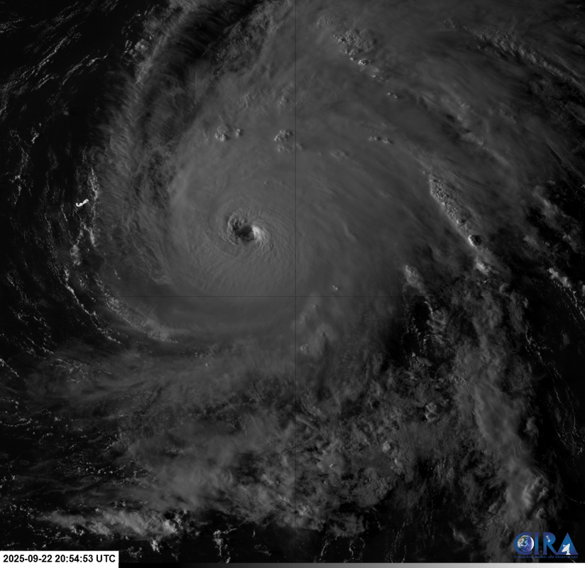
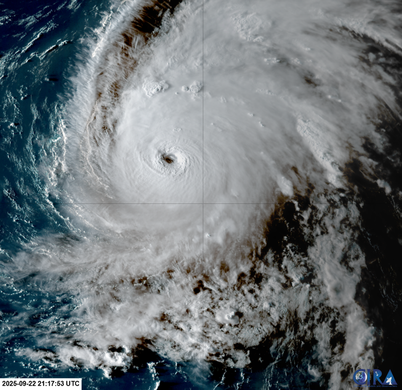
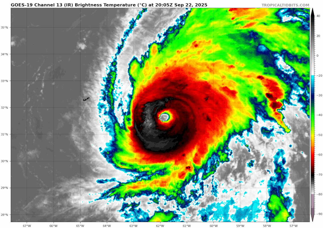
#290 Postby MEANINGLESS_NUMBERS » Mon Sep 22, 2025 6:34 pm

I hope everyone wondering why there was recon in a fish storm is satisfied with the answer! This was a huge miss by the models, the most of aggressive of which still underestimated the speed of RI. Understanding these storms is so important so that forecast misses like this don’t happen again. In this case it fortunately doesn’t matter but imagine a Cat 1 forecast turning into a Cat 4 landfall within 24 hours. Could have been so bad.
8 likes   
Emily '87, Felix '95, Gert '99, Fabian '03, Humberto '19, Paulette '20, Teddy '20, Fiona '22, Lee '23, Ernesto '24, Humberto/Imelda '25

User avatar
StormWeather
Category 1
Category 1
Posts: 472
Joined: Wed Jun 05, 2024 2:34 pm

Re: NATL: GABRIELLE - Hurricane - Discussion

#291 Postby StormWeather » Mon Sep 22, 2025 6:38 pm

MEANINGLESS_NUMBERS wrote:I hope everyone wondering why there was recon in a fish storm is satisfied with the answer! This was a huge miss by the models, the most of aggressive of which still underestimated the speed of RI. Understanding these storms is so important so that forecast misses like this don’t happen again. In this case it fortunately doesn’t matter but imagine a Cat 1 forecast turning into a Cat 4 landfall within 24 hours. Could have been so bad.

I wish we still had recon in storm, because im interested to see whether it’s reached 130 kts or more yet.
2 likes   
Just an average cyclone tracker

The posts in this forum are NOT official forecasts and should not be used as such. They are just the opinion of the poster and may or may not be backed by sound meteorological data. They are NOT endorsed by any professional institution or storm2k.org. For official information, please refer to the NHC and NWS products

User avatar
storm_in_a_teacup
Category 1
Category 1
Posts: 493
Age: 33
Joined: Wed Aug 16, 2017 5:01 pm
Location: Huntsville, Alabama (originally from Houston)
Contact:

Re: NATL: GABRIELLE - Hurricane - Discussion

#292 Postby storm_in_a_teacup » Mon Sep 22, 2025 6:38 pm


OMG just saved this to my meme stash
4 likes   
I know I can't straddle the atmosphere...just a tiny storm in your teacup, girl.

User avatar
Hurricane2022
Category 5
Category 5
Posts: 1949
Joined: Tue Aug 23, 2022 11:38 pm
Location: Araçatuba, Brazil

Re: NATL: GABRIELLE - Hurricane - Discussion

#293 Postby Hurricane2022 » Mon Sep 22, 2025 6:49 pm

Cool.
Image
Image
4 likes   
Sorry for the bad English sometimes...!
For reliable and detailed information for any meteorological phenomenon, please consult the National Hurricane Center, Joint Typhoon Warning Center , or your local Meteo Center.

--------

ECCE OMNIA NOVA FACIAM (Ap 21,5).

User avatar
AnnularCane
S2K Supporter
S2K Supporter
Posts: 2945
Joined: Thu Jun 08, 2006 9:18 am
Location: Wytheville, VA

Re: NATL: GABRIELLE - Hurricane - Discussion

#294 Postby AnnularCane » Mon Sep 22, 2025 6:54 pm

MEANINGLESS_NUMBERS wrote:I hope everyone wondering why there was recon in a fish storm is satisfied with the answer! This was a huge miss by the models, the most of aggressive of which still underestimated the speed of RI. Understanding these storms is so important so that forecast misses like this don’t happen again. In this case it fortunately doesn’t matter but imagine a Cat 1 forecast turning into a Cat 4 landfall within 24 hours. Could have been so bad.


I never even wondered about it, I just figured since she was in recon range... :) Considering how wonky models can be with intensity, I'm surprised forecast misses like that haven't happened more often.
1 likes   
"But it never rained rain. It never snowed snow. And it never blew just wind. It rained things like soup and juice. It snowed mashed potatoes and green peas. And sometimes the wind blew in storms of hamburgers." -- Judi Barrett, Cloudy with a Chance of Meatballs

User avatar
syfr
S2K Supporter
S2K Supporter
Posts: 223
Age: 106
Joined: Fri Oct 26, 2012 7:33 pm
Location: East Central NC

Re: NATL: GABRIELLE - Hurricane - Discussion

#295 Postby syfr » Mon Sep 22, 2025 7:03 pm

What a metamorphosis in 36 hours!

Spectacular.
2 likes   
I'm not a meteorologist, I'm an electronics engineer. While I can probably fix your toaster oven, you're not going to learn about storms from me!

New Mexico had no hurricanes. Then I moved to NC right before Fran.....

Craters
Category 1
Category 1
Posts: 428
Joined: Sat Aug 24, 2013 2:34 pm
Location: Alvin, TX (south of Houston)

Re: NATL: GABRIELLE - Hurricane - Discussion

#296 Postby Craters » Mon Sep 22, 2025 7:27 pm

zzzh wrote:
...GABRIELLE RAPIDLY INTENSIFIES INTO A MAJOR HURRICANE SOUTHEAST OF BERMUDA...

Good call, Kevin!
0 likes   
Nothing that I post here should ever be treated as a forecast or anything resembling one. Please check with your local NWS office or the NHC for forecasts, watches, and warnings.

User avatar
sasha_B
Category 1
Category 1
Posts: 283
Age: 25
Joined: Sun Jun 30, 2024 4:32 pm
Location: Charleston, SC

Re: NATL: GABRIELLE - Hurricane - Discussion

#297 Postby sasha_B » Mon Sep 22, 2025 7:35 pm

07L GABRIELLE 250923 0000 32.1N 61.4W ATL 120 948


Intensity held at 120 kts / 948 hPa for the 0z best track point.
0 likes   

User avatar
cycloneye
Admin
Admin
Posts: 148542
Age: 69
Joined: Thu Oct 10, 2002 10:54 am
Location: San Juan, Puerto Rico

Re: NATL: GABRIELLE - Hurricane - Discussion

#298 Postby cycloneye » Mon Sep 22, 2025 7:36 pm

AL, 07, 2025092300, , BEST, 0, 321N, 614W, 120, 948, HU
1 likes   
Visit the Caribbean-Central America Weather Thread where you can find at first post web cams,radars
and observations from Caribbean basin members Click Here

User avatar
Buck
S2K Supporter
S2K Supporter
Posts: 1199
Joined: Fri Sep 10, 2004 12:04 pm
Location: Atlanta, GA

Re: NATL: GABRIELLE - Hurricane - Discussion

#299 Postby Buck » Mon Sep 22, 2025 7:39 pm

A few more overperforming fish and we might catch up on ACE. Gabi has been fun to watch.
1 likes   

User avatar
weeniepatrol
Category 5
Category 5
Posts: 1339
Joined: Sat Aug 22, 2020 5:30 pm
Location: WA State

Re: NATL: GABRIELLE - Hurricane - Discussion

#300 Postby weeniepatrol » Mon Sep 22, 2025 8:04 pm

Sorry if repost :D

Image
5 likes   


Return to “2025”

Who is online

Users browsing this forum: Google Adsense [Bot] and 24 guests