NATL: IMELDA - Models
Moderator: S2k Moderators
-
Hypercane_Kyle

- Category 5

- Posts: 3465
- Joined: Sat Mar 07, 2015 7:58 pm
- Location: Cape Canaveral, FL
Re: NATL: INVEST 94L - Models
Total crapshoot for track right now, the models are not going to handle a solution involving the complex interaction between two storms very well at all. Florida to Bermuda needs to be on the watch for a potential storm in ~5 days.
4 likes
My posts are my own personal opinion, defer to the National Hurricane Center (NHC) and other NOAA products for decision making during hurricane season.
-
floridasun
- Tropical Storm

- Posts: 245
- Joined: Tue Sep 14, 2021 3:59 pm

Re: NATL: INVEST 94L - Models
18z Euro AI interesting to say the least. Rides 94l up the FL east coast as a hurricane to JAX, stalls and then sling shots 93l NW off eastern NC. The two systems then merge off eastern NC and the new storm bombs out as it very slowly moves north off the Mid-Atlantic coast. My my.
4 likes
-
Category5Kaiju

- Category 5
- Posts: 4352
- Joined: Thu Dec 24, 2020 12:45 pm
- Location: Seattle during the summer, Phoenix during the winter
Re: NATL: INVEST 94L - Models
ronjon wrote:18z Euro AI interesting to say the least. Rides 94l up the FL east coast as a hurricane to JAX, stalls and then sling shots 93l NW off eastern NC. The two systems then merge off eastern NC and the new storm bombs out as it very slowly moves north off the Mid-Atlantic coast. My my.
And we'll call it....Hurricane Humbelda.
5 likes
Unless explicitly stated, all information in my posts is based on my own opinions and observations. Tropical storms and hurricanes can be extremely dangerous. Refer to an accredited weather research agency or meteorologist if you need to make serious decisions regarding an approaching storm.

Re: NATL: INVEST 94L - Models
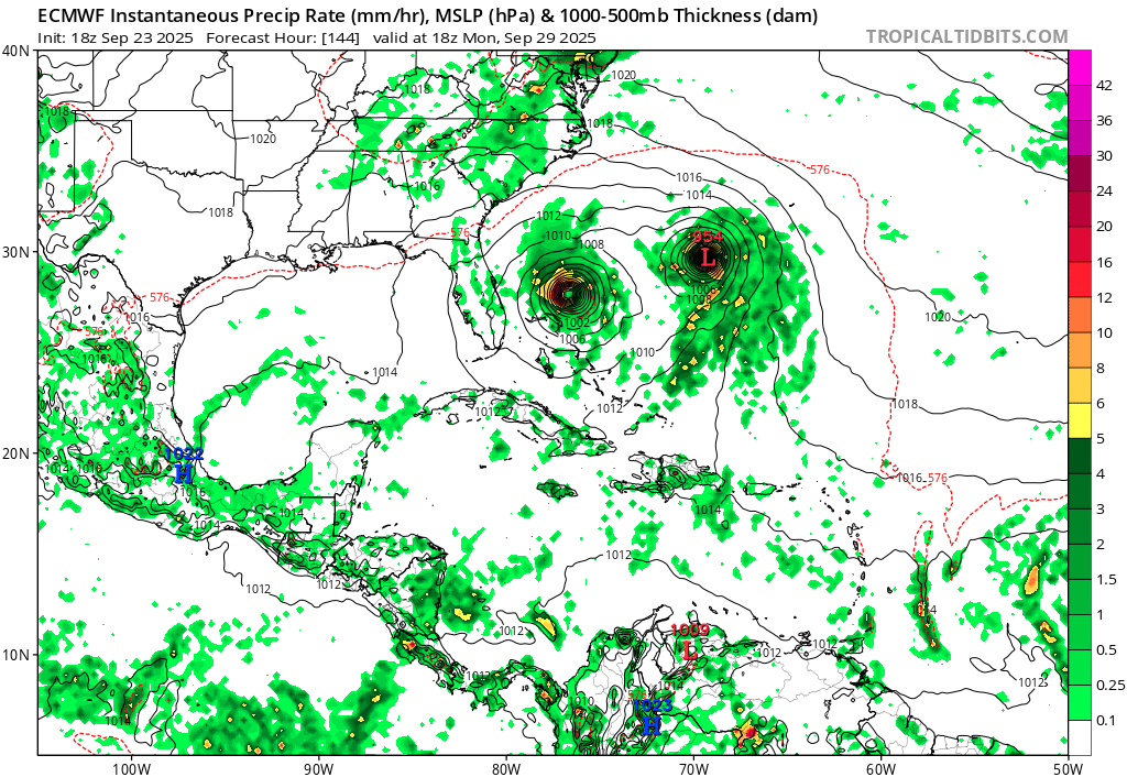
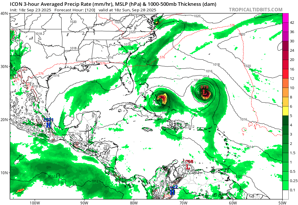
A surprising number of operational models are now not just developing both 93L and 94L, but having both grow into significant hurricanes - and often, extremely close to each other. This trend started at 12z today and continued into 18z.
18z ECMWF. This is the end of the run, and both storms are stronger than 12z.
18z ICON. Compared to the 12z run, 93L's intensity is about the same, and 94L is only a tad weaker.
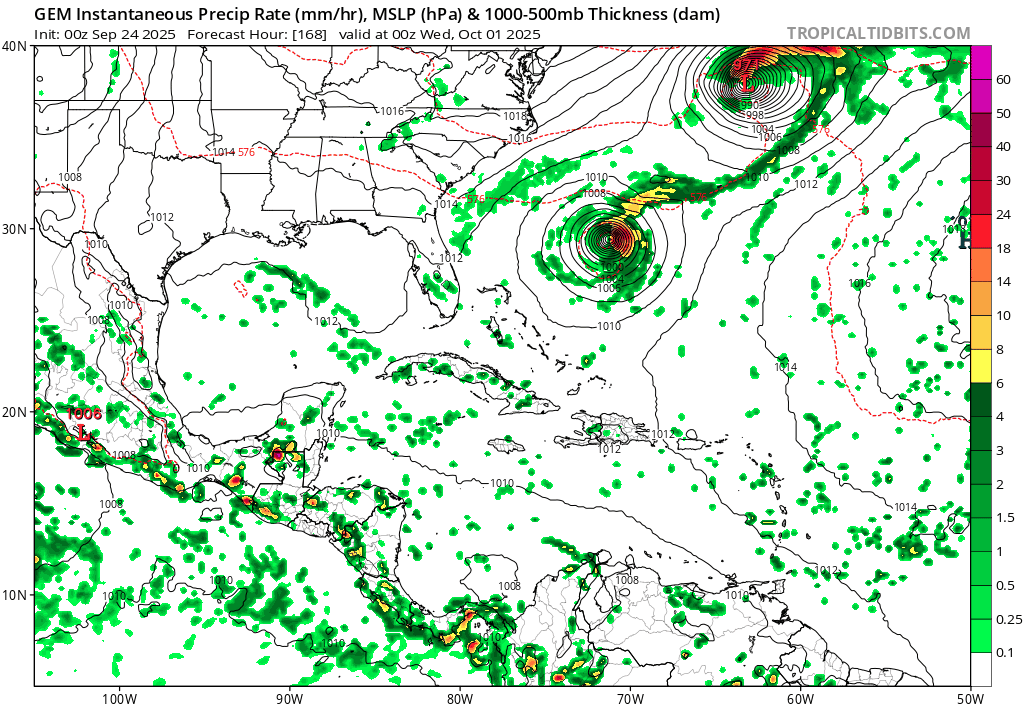
12z CMC, showing a loop with the peaks of both storms.
18z GFS. While much weaker in intensity, the GFS has never really been enthusiastic with either 93L or 94L becoming strong hurricanes. This is also the first GFS run clearly showing both co-existing as TCs. You can argue that it's playing catchup.
Does that give us any certainty? No.
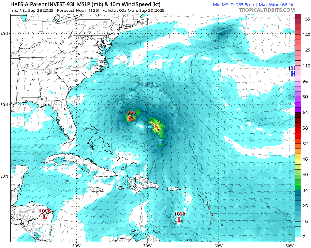
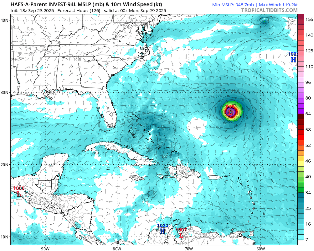
Look no further than 18z HAFS-A Parent: Same model, same init time, just initialized on the two different systems.
18z HAFS-A Parent for 93L: A full Fujiwhara between the two storms, neither of which getting beyond a minimal hurricane at most.
18z HAFS-A Parent for 94L: The "other" storm, 93L, cleanly separates and bombs out. Meanwhile, 94L's vorticity crosses through the Greater Antilles, and slowly organizes from a broad, weak low at the end of the run.
The hurricanes models in general are much less enthusiastic on intensification - or development at all - than the global models.
I don't know why there's such a difference. Perhaps the hurricane models are designed for forecasting a single storm, and struggles with interactions of multiple systems?
18z ECMWF. This is the end of the run, and both storms are stronger than 12z.
18z ICON. Compared to the 12z run, 93L's intensity is about the same, and 94L is only a tad weaker.
12z CMC, showing a loop with the peaks of both storms.
18z GFS. While much weaker in intensity, the GFS has never really been enthusiastic with either 93L or 94L becoming strong hurricanes. This is also the first GFS run clearly showing both co-existing as TCs. You can argue that it's playing catchup.
Does that give us any certainty? No.
Look no further than 18z HAFS-A Parent: Same model, same init time, just initialized on the two different systems.
18z HAFS-A Parent for 93L: A full Fujiwhara between the two storms, neither of which getting beyond a minimal hurricane at most.
18z HAFS-A Parent for 94L: The "other" storm, 93L, cleanly separates and bombs out. Meanwhile, 94L's vorticity crosses through the Greater Antilles, and slowly organizes from a broad, weak low at the end of the run.
The hurricanes models in general are much less enthusiastic on intensification - or development at all - than the global models.
I don't know why there's such a difference. Perhaps the hurricane models are designed for forecasting a single storm, and struggles with interactions of multiple systems?
2 likes
TC naming lists: retirements and intensity
Most aggressive Advisory #1's in North Atlantic (cr. kevin for starting the list)
Most aggressive Advisory #1's in North Atlantic (cr. kevin for starting the list)
Re: NATL: INVEST 94L - Models
How close can two major hurricanes be?
Irma and Jose 2017 are probably the poster boys of two MHs co-existing much closer than one would expect. While both are thought of as MDR hurricanes, counter-intuitively, their closest approach as MHs was when Irma made landfall in Naples FL, while Jose was gaining latitude north of Puerto Rico (18z 9/10/2017). At that time, they were 988 miles apart.
The record for closest co-existing MHs actually belongs to Easy and Fox 1951, both recurving CV storms. At 0z on 9/8/1951, Easy was in the western Atlantic while Fox was in the central Atlantic, 866 miles apart. (The second place belongs to Dog and Easy 1950.)
The 18z Euro run, however, has 93L and 94L become what seems like MHs while being a mere... ~480 miles apart. If it happens, that would cut the previous record almost in half!
1 likes
TC naming lists: retirements and intensity
Most aggressive Advisory #1's in North Atlantic (cr. kevin for starting the list)
Most aggressive Advisory #1's in North Atlantic (cr. kevin for starting the list)
Re: NATL: INVEST 94L - Models
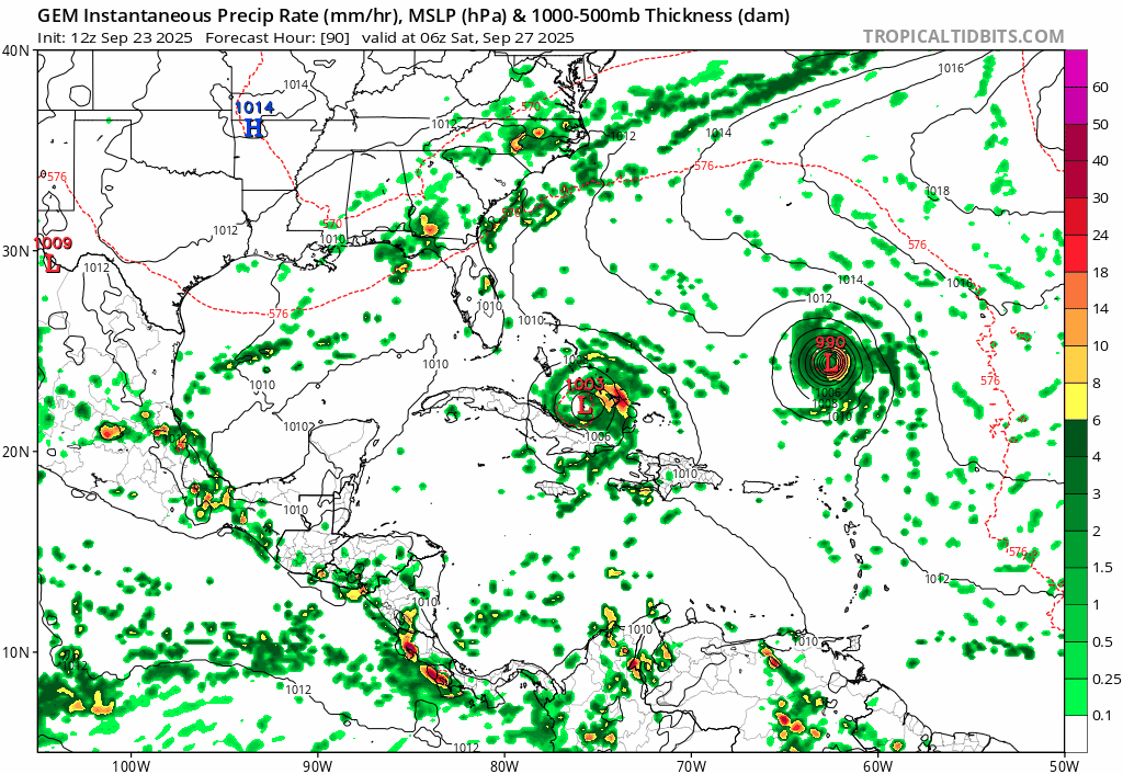
0z GFS: Still develops both and heavily Fujiwhara until they merge, weaker than 18z
0z ICON: 93L is 930 mb through Bermuda and 94L still bombs out afterwards
0z CMC: One of the few times where a model storm moves due south
0z ICON: 93L is 930 mb through Bermuda
and 94L still bombs out afterwards 0z CMC: One of the few times where a model storm moves due south
2 likes
TC naming lists: retirements and intensity
Most aggressive Advisory #1's in North Atlantic (cr. kevin for starting the list)
Most aggressive Advisory #1's in North Atlantic (cr. kevin for starting the list)

Re: NATL: INVEST 94L - Models
00z Euro shows 94L becoming a TS around +96 hr near the Bahamas. Travels NW and becomes a hurricane close to the South Carolina coast at +150 hr. Then travels SE without making landfall and bombs out to a 957 mb MH. Afterwards it follows 93L OTS and weakens to a minimal hurricane or TS for the remainder of its lifetime. Directly impacts Bermuda as a TS at +216 hr.
0 likes

Re: NATL: INVEST 94L - Models
It seems the current question is whether 93 will be able to pull 94 out to see with it or not.
0 likes
Re: NATL: INVEST 94L - Models
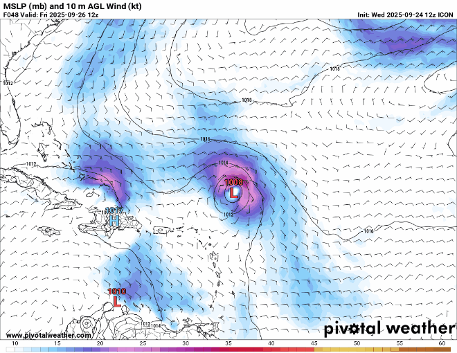
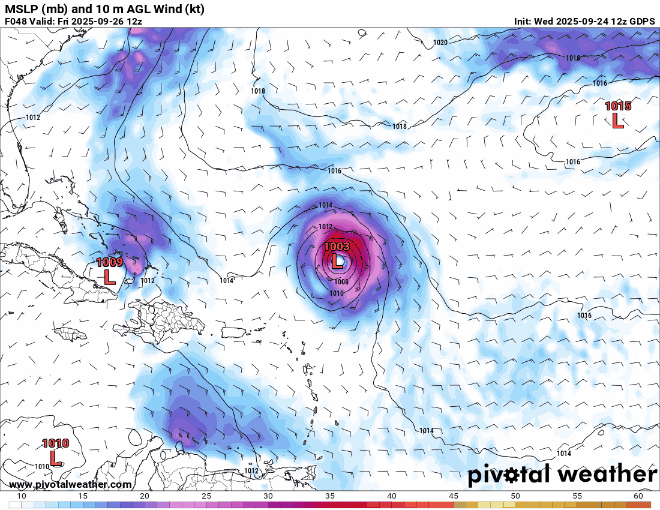
12z ICON has a near-stall close to the Bahamas between +120 and +180 hr which allows 94L to grow from a sheared TS (due to 93L) to a MH.

1 likes
Re: NATL: INVEST 94L - Models
kevin wrote:12z ICON has a near-stall close to the Bahamas between +120 and +180 hr which allows 94L to grow from a sheared TS (due to 93L) to a MH.
https://i.imgur.com/mYpSsp6.png
That would mean a stall over the general region of the Bahamas for almost 5 days. Enough to bring major flooding problems regardless of intensity.
2 likes
TC naming lists: retirements and intensity
Most aggressive Advisory #1's in North Atlantic (cr. kevin for starting the list)
Most aggressive Advisory #1's in North Atlantic (cr. kevin for starting the list)
Re: NATL: INVEST 94L - Models
Animated icon (the two system interaction is hard to convey in stills)
2 likes
Re: NATL: INVEST 94L - Models
Late news, but...
On last night's 0z EPS, there were enough ensemble members that bring 94L into the Carolinas or Georgia, some as hurricanes. Other members recurve (or threaten Bermuda) after interactions with 93L. Either way, there's still great uncertainty.
(And then of course, there's that one (1) member that hits SFL and then FL Panhandle.)
2 likes
TC naming lists: retirements and intensity
Most aggressive Advisory #1's in North Atlantic (cr. kevin for starting the list)
Most aggressive Advisory #1's in North Atlantic (cr. kevin for starting the list)
-
TampaWxLurker
- Tropical Storm
- Posts: 196
- Joined: Thu Aug 01, 2024 8:20 am
Re: NATL: INVEST 94L - Models
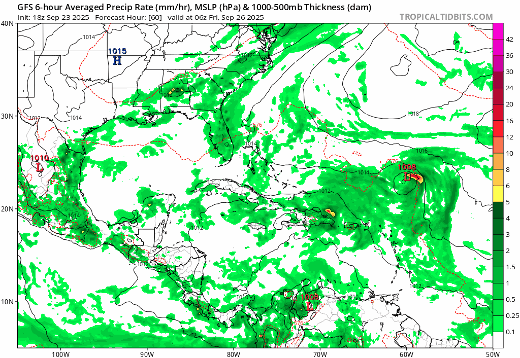
Thru 132 hours, 12z GFS keeps 93L the dominant system, with 94L remaining weak and getting affected by dry air on the west, outflow from major hurricane 94L on the east and high shear on top of it. Barely-to-not-at-all developed on this run.
Edit: Looks like 94L's remnant is following 93L northeast thru 150 hours and getting absorbed into 93L's tail.
Edit: Looks like 94L's remnant is following 93L northeast thru 150 hours and getting absorbed into 93L's tail.
1 likes
Re: NATL: INVEST 94L - Models
12Z UK 94L: TD just NE of C Bahamas moving ESE
NEW TROPICAL CYCLONE FORECAST TO DEVELOP AFTER 108 HOURS
FORECAST POSITION AT T+108 : 24.5N 77.2W
LEAD CENTRAL MAXIMUM WIND
VERIFYING TIME TIME POSITION PRESSURE (MB) SPEED (KNOTS)
-------------- ---- -------- ------------- -------------
0000UTC 29.09.2025 108 24.5N 77.2W 1008 28
1200UTC 29.09.2025 120 25.0N 77.0W 1008 27
0000UTC 30.09.2025 132 25.0N 77.1W 1007 27
1200UTC 30.09.2025 144 24.4N 76.6W 1006 24
0000UTC 01.10.2025 156 23.9N 75.0W 1005 25
1200UTC 01.10.2025 168 CEASED TRACKING
1 likes
Personal Forecast Disclaimer:
The posts in this forum are NOT official forecasts and should not be used as such. They are just the opinion of the poster and may or may not be backed by sound meteorological data. They are NOT endorsed by any professional institution or storm2k.org. For official information, please refer to the NHC and NWS products.
The posts in this forum are NOT official forecasts and should not be used as such. They are just the opinion of the poster and may or may not be backed by sound meteorological data. They are NOT endorsed by any professional institution or storm2k.org. For official information, please refer to the NHC and NWS products.
Re: NATL: INVEST 94L - Models
The 12z GFS (again) never really develops 94L.
The 12z Canadian hasn't ran for whatever reason.
The 12z Canadian hasn't ran for whatever reason.
1 likes

Re: NATL: INVEST 94L - Models
UK and GFS pretty much on the same page. I mean, forget what nomenclature we or NHC might use to define "a T.D.". Whether SLP for 94L drops to 1008, 1006, or 1004mb's.... bottom line is that by 168 hr's, both GFS and UK forecast 94L to be absorbed by the stronger 93L to its east.
Sure, that's no guarantee of what will transpire but when I look at the ICON 200 mb forecast verses the EURO & GFS, I have a harder time buying into the ICON solution. The ICON projects that a dominant upper level ridge won't be over the deepening 93L but rather will expand from the N. Caribbean and shift northward to the Bahamas, right up against a sharpening southern tier CONUS 200 mb jet extending southward over Florida. That may enhance UL divergence but I would think too strong for 94L to maintain vertical integrity and deepen. I would think 94L would eventually have its mid level vorticity pulled to the northeast and absorbed by 93L. Essentially, that seems to be one factor leading the GFS and UK toward a very different solution then ICON.
Sure, that's no guarantee of what will transpire but when I look at the ICON 200 mb forecast verses the EURO & GFS, I have a harder time buying into the ICON solution. The ICON projects that a dominant upper level ridge won't be over the deepening 93L but rather will expand from the N. Caribbean and shift northward to the Bahamas, right up against a sharpening southern tier CONUS 200 mb jet extending southward over Florida. That may enhance UL divergence but I would think too strong for 94L to maintain vertical integrity and deepen. I would think 94L would eventually have its mid level vorticity pulled to the northeast and absorbed by 93L. Essentially, that seems to be one factor leading the GFS and UK toward a very different solution then ICON.
0 likes
Andy D
(For official information, please refer to the NHC and NWS products.)
(For official information, please refer to the NHC and NWS products.)
Re: NATL: INVEST 94L - Models
12z UK. Gets further west/more developed than the GFS, but does get pulled in later. Bahamas no good for cruising this weekend that's for sure.

0 likes
-
jlauderdal
- S2K Supporter

- Posts: 7240
- Joined: Wed May 19, 2004 5:46 am
- Location: NE Fort Lauderdale
- Contact:
Re: RE: Re: NATL: INVEST 94L - Models
Magical power we have in SE FloridaBobHarlem wrote:12z Canadian
Sent from my Pixel 9 using Tapatalk
2 likes
Who is online
Users browsing this forum: No registered users and 26 guests