WPAC: BUALOI - Post-Tropical

Moderator: S2k Moderators

Message
Author
User avatar
Hayabusa
Category 5
Category 5
Posts: 4640
Joined: Sun Sep 16, 2018 1:05 pm

Re: WPAC: Tropical Depression 92W

#21 Postby Hayabusa » Mon Sep 22, 2025 5:31 pm

Up to medium
ABPW10 PGTW 222200
MSGID/GENADMIN/JOINT TYPHOON WRNCEN PEARL HARBOR HI//
SUBJ/SIGNIFICANT TROPICAL WEATHER ADVISORY FOR THE WESTERN AND SOUTH
PACIFIC OCEANS REISSUED/222200Z-230600ZSEP2025//
REF/A/MSG/JOINT TYPHOON WRNCEN PEARL HARBOR HI/221951ZSEP2025//
REF/B/MSG/JOINT TYPHOON WRNCEN PEARL HARBOR HI/221952ZSEP2025//
NARR/REFS A AND B ARE TROPICAL CYCLONE WARNINGS.//
RMKS/
1. WESTERN NORTH PACIFIC AREA (180 TO MALAY PENINSULA):
A. TROPICAL CYCLONE SUMMARY:
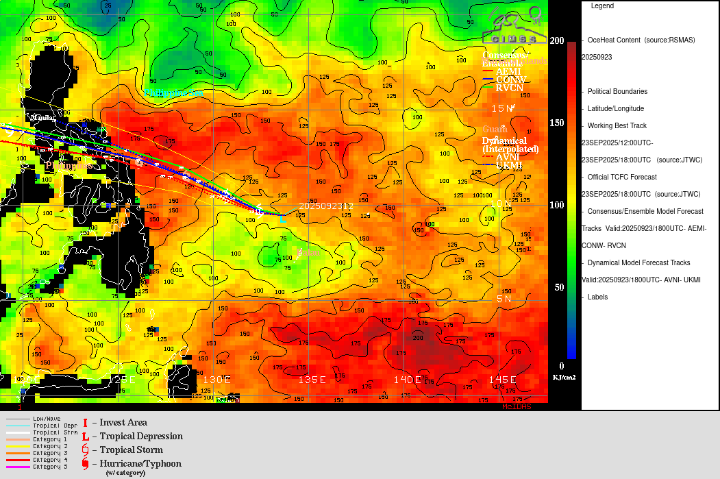
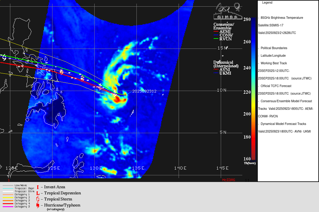
(1) AT 22SEP25 1800Z, TYPHOON 24W (RAGASA) WAS LOCATED NEAR
19.6N 119.3E, APPROXIMATELY 328 NM EAST- SOUTHEAST OF HONG KONG, AND
HAD TRACKED WESTWARD AT 11 KNOTS OVER THE PAST SIX HOURS. MAXIMUM
SUSTAINED SURFACE WINDS WERE ESTIMATED AT 125 KNOTS GUSTING TO 150
KNOTS. SEE REF A (WTPN32 PGTW 222100) FOR FURTHER DETAILS.
(2) AT 22SEP25 1800Z, TYPHOON 25W (NEOGURI) WAS LOCATED NEAR
30.5N 152.8E, APPROXIMATELY 383 NM NORTH OF MINAMI TORI SHIMA, AND HAD
TRACKED EAST-NORTHEASTWARD AT 05 KNOTS OVER THE PAST SIX HOURS.
MAXIMUM SUSTAINED SURFACE WINDS WERE ESTIMATED AT 80 KNOTS GUSTING TO
100 KNOTS. SEE REF B (WTPN33 PGTW 222100) FOR FURTHER DETAILS.
(3) NO OTHER TROPICAL CYCLONES.
B. TROPICAL DISTURBANCE SUMMARY:
(1) THE AREA OF CONVECTION (INVEST 92W) PREVIOUSLY LOCATED NEAR
10.4N 139.2E IS NOW LOCATED NEAR 11.1N 138.2E, APPROXIMATELY 94 NM
NORTH OF YAP. ANIMATED ENHANCED INFRARED SATELLITE IMAGERY (EIR)
DEPICTS PERSISTENT DEEP CONVECTION WITH RAIN BANDS BEGINNING TO
ORGANIZE. IT ALSO SHOWS A SLOWLY CONSOLIDATING LOW LEVEL CIRCULATION
CENTER (LLCC). THE ENVIRONMENT IS FAVORABLE FOR DEVELOPMENT WITH WARM
SEA SURFACE TEMPERATURES (29-30 C) AND MODERATE VERTICAL WIND SHEAR
(15-20 KTS), AND GOOD EQUATORWARD OUTFLOW ALOFT. GLOBAL DETERMINISTIC
MODELS ARE IN GOOD AGREEMENT THAT 92W WILL INTENSIFY OVER THE NEXT 48
HOURS WITH GFS BEING THE MOST INTENSE. GLOBAL ENSEMBLE MODELS ARE IN
AGREEMENT AS WELL THAT 92W WILL CONTINUE TO MOVE WESTWARD AND
INTENSIFY OVER THE NEXT 48 HOURS. MAXIMUM SUSTAINED SURFACE WINDS ARE
ESTIMATED AT 13 TO 18 KNOTS. MINIMUM SEA LEVEL PRESSURE IS ESTIMATED
TO BE NEAR 1008 MB. THE POTENTIAL FOR THE DEVELOPMENT OF A SIGNIFICANT
TROPICAL CYCLONE WITHIN THE NEXT 24 HOURS IS UPGRADED TO MEDIUM.
(2) NO OTHER SUSPECT AREAS.
C. SUBTROPICAL SYSTEM SUMMARY: NONE.
2. SOUTH PACIFIC AREA (WEST COAST OF SOUTH AMERICA TO 135 EAST):
A. TROPICAL CYCLONE SUMMARY: NONE.
B. TROPICAL DISTURBANCE SUMMARY: NONE.
C. SUBTROPICAL SYSTEM SUMMARY: NONE.
3. JUSTIFICATION FOR REISSUE: UPGRADED AREA IN PARA 1.B.(1) TO
MEDIUM.//
NNNN
0 likes   
ヤンデレ女が寝取られるているのを見たい!!!
ECMWF ensemble NWPAC plots: https://ecmwfensnwpac.imgbb.com/
Multimodel NWPAC plots: https://multimodelnwpac.imgbb.com/
GFS Ensemble NWPAC plots (16 & 35 day forecast): https://gefsnwpac.imgbb.com/
Plots updated automatically

User avatar
mrbagyo
Category 5
Category 5
Posts: 3812
Age: 33
Joined: Thu Apr 12, 2012 9:18 am
Location: 14.13N 120.98E
Contact:

Re: WPAC: Tropical Depression 92W

#22 Postby mrbagyo » Mon Sep 22, 2025 7:25 pm

Image
1 likes   
The posts in this forum are NOT official forecast and should not be used as such. They are just the opinion of the poster and may or may not be backed by sound meteorological data. They are NOT endorsed by any professional institution or storm2k.org. For official information, please refer to RSMC, NHC and NWS products.

User avatar
cycloneye
Admin
Admin
Posts: 147569
Age: 69
Joined: Thu Oct 10, 2002 10:54 am
Location: San Juan, Puerto Rico

Re: WPAC: Tropical Depression 92W

#23 Postby cycloneye » Mon Sep 22, 2025 9:29 pm

0 likes   
Visit the Caribbean-Central America Weather Thread where you can find at first post web cams,radars
and observations from Caribbean basin members Click Here

User avatar
cycloneye
Admin
Admin
Posts: 147569
Age: 69
Joined: Thu Oct 10, 2002 10:54 am
Location: San Juan, Puerto Rico

Re: WPAC: Tropical Depression 92W

#24 Postby cycloneye » Mon Sep 22, 2025 10:03 pm

PAGASA with first warning.

TROPICAL CYCLONE ADVISORY NR. 1
Tropical Depression
Issued at 11:00 AM, 23 September 2025
Valid for broadcast until the next bulletin at 11:00 PM today.
THE LOW PRESSURE AREA EAST OF SOUTHERN LUZON DEVELOPED INTO A TROPICAL DEPRESSION.
• Location of Center (10:00 AM)
The center of the Tropical Depression was estimated based on all available data at 1,075 km East of Eastern Visayas (OUTSIDE PAR) (10.7°N, 135.6°E).
• Intensity
Maximum sustained winds of 55 km/h near the center, gustiness of up to 70 km/h, and central pressure of 1006 hPa.
• Present Movement
Westward at 35 km/h
• Extent of Tropical Cyclone Winds
Strong winds extend outwards up to 160 km from the center
GENERAL OUTLOOK FOR THE FORECAST PERIOD
• The tropical depression (TD) is forecast to move generally westward for the next 36 hours and will enter the Philippine Area of Responsibility (PAR) this afternoon or evening and will be given a local name “OPONG”.
• Inside PAR, OPONG is expected to move generally west northwestward as it approaches Eastern Visayas – Southern Luzon area by Friday (26 September) morning. It is expected to cross the Southern Luzon area (Bicol Region – CALABARZON – MIMAROPA) between Friday and Saturday (27 September) and may exit the PAR by Saturday evening. Note that there is still a high uncertainty in the scenario and the track may still change, but still within the area of probability.
• This weather disturbance will steadily intensify while over the Philippine Sea and may reach tropical storm category by tomorrow (24 September). Further intensification is not ruled out. Based on the intensity forecast, hoisting of Wind Signal No. 2 over portions of Southern Luzon and Eastern Visayas is likely. However, further intensification may result in hoisting of Wind Signal No. 3 (highest possible signal).
• The tropical depression outside PAR is less likely to directly affect the weather and sea condition in the next 36 hours. Wind Signal No. 1 will be hoisted over Eastern Visayas as early as tomorrow. Onset of heavy rains directly caused by this weather disturbance is possible by Thursday (25 September).
• This weather disturbance may bring moderate to rough seas over the coastal waters of Eastern Visayas and northeastern Mindanao starting Thursday afternoon. Gale Warning may be raised over Eastern Visayas and Bicol Region as early as Thursday afternoon in anticipation of rough to very rough sea conditions.
Considering these developments, the public and disaster risk reduction and management offices concerned are advised to continue monitoring for updates related to this tropical cyclone.
Unless there is an intermediate issuance, the next tropical cyclone advisory will be issued at 11:00 PM today.


Image
0 likes   
Visit the Caribbean-Central America Weather Thread where you can find at first post web cams,radars
and observations from Caribbean basin members Click Here

User avatar
Hayabusa
Category 5
Category 5
Posts: 4640
Joined: Sun Sep 16, 2018 1:05 pm

Re: WPAC: Tropical Depression 92W

#25 Postby Hayabusa » Tue Sep 23, 2025 12:05 am

JMA TC warning since 00z
Image
TD a
Issued at 2025/09/23 04:15 UTC
Analysis at 09/23 03 UTC
Grade TD
Scale -
Intensity -
Center position N10°55′ (10.9°)
E135°50′ (135.8°)
Direction and speed of movement W Slow
Central pressure 1004 hPa
Maximum wind speed 15 m/s (30 kt)
Maximum wind gust speed 23 m/s (45 kt)
0 likes   
ヤンデレ女が寝取られるているのを見たい!!!
ECMWF ensemble NWPAC plots: https://ecmwfensnwpac.imgbb.com/
Multimodel NWPAC plots: https://multimodelnwpac.imgbb.com/
GFS Ensemble NWPAC plots (16 & 35 day forecast): https://gefsnwpac.imgbb.com/
Plots updated automatically

User avatar
Hayabusa
Category 5
Category 5
Posts: 4640
Joined: Sun Sep 16, 2018 1:05 pm

Re: WPAC: Tropical Depression 92W

#26 Postby Hayabusa » Tue Sep 23, 2025 12:06 am

TCFA since 0200z
Image
WTPN21 PGTW 230200
MSGID/GENADMIN/JOINT TYPHOON WRNCEN PEARL HARBOR HI//
SUBJ/TROPICAL CYCLONE FORMATION ALERT (INVEST 92W)//
RMKS/
1. FORMATION OF A SIGNIFICANT TROPICAL CYCLONE IS POSSIBLE WITHIN
100 NM EITHER SIDE OF A LINE FROM 10.2N 138.4E TO 10.5N 134.3E
WITHIN THE NEXT 12 TO 24 HOURS. AVAILABLE DATA DOES NOT JUSTIFY
ISSUANCE OF NUMBERED TROPICAL CYCLONE WARNINGS AT THIS TIME.
WINDS IN THE AREA ARE ESTIMATED TO BE 18 TO 22 KNOTS. METSAT
IMAGERY AT 230000Z INDICATES THAT A CIRCULATION CENTER IS LOCATED
NEAR 10.2N 138.2E. THE SYSTEM IS MOVING WESTWARD AT 03 KNOTS.
2. REMARKS: THE AREA OF CONVECTION (INVEST 92W) PREVIOUSLY LOCATED NEAR
11.1N 138.2E IS NOW LOCATED 10.2N 138.2E, APPROXIMATELY 40.3 NM NORTH OF
YAP. ANIMATED MULTISPECTRAL SATELLITE IMAGERY (MSI) SHOWS PERSISTENT
DEEP CONVECTION CONSOLIDATING OVER A DEVELOPING LOW LEVEL CIRCULATION
CENTER. A 230035Z ASCAT VERIFIES A CLOSED CIRCULATION HAS DEVELOPED,
WITH 15-20 KNOT WINDS WRAPPING FROM THE NORTH OF THE CIRCULATION CENTER.
THE ENVIRONMENT IS FAVORABLE FOR DEVELOPMENT WITH WARM SEA SURFACE
TEMPERATURES (29-30 C) AND MODERATE VERTICAL WIND SHEAR (15-20 KTS) AND
GOOD EQUATORWARD OUTFLOW ALOFT. GLOBAL DETERMINISTIC MODELS ARE IN GOOD
AGREEMENT THAT 92W WILL INTENSIFY OVER THE NEXT 24 HOURS. GLOBAL
ENSEMBLE MODELS ARE IN AGREEMENT AS WELL THAT 92W WILL CONTINUE TO MOVE
WESTWARD AND INTENSIFY OVER THE NEXT 24 HOURS. MAXIMUM SUSTAINED SURFACE
WINDS ARE ESTIMATED AT 18 TO 22 KNOTS. MINIMUM SEA LEVEL PRESSURE IS
ESTIMATED TO BE NEAR 1007 MB. THE POTENTIAL FOR THE DEVELOPMENT OF A
SIGNIFICANT TROPICAL CYCLONE WITHIN THE NEXT 24 HOURS IS HIGH.
3. THIS ALERT WILL BE REISSUED, UPGRADED TO WARNING OR CANCELLED BY
240200Z.
//
NNNN
0 likes   
ヤンデレ女が寝取られるているのを見たい!!!
ECMWF ensemble NWPAC plots: https://ecmwfensnwpac.imgbb.com/
Multimodel NWPAC plots: https://multimodelnwpac.imgbb.com/
GFS Ensemble NWPAC plots (16 & 35 day forecast): https://gefsnwpac.imgbb.com/
Plots updated automatically

User avatar
Hayabusa
Category 5
Category 5
Posts: 4640
Joined: Sun Sep 16, 2018 1:05 pm

Re: WPAC: Tropical Depression 92W

#27 Postby Hayabusa » Tue Sep 23, 2025 3:25 am

It entered PAR at 4pm, will be locally named Opong
0 likes   
ヤンデレ女が寝取られるているのを見たい!!!
ECMWF ensemble NWPAC plots: https://ecmwfensnwpac.imgbb.com/
Multimodel NWPAC plots: https://multimodelnwpac.imgbb.com/
GFS Ensemble NWPAC plots (16 & 35 day forecast): https://gefsnwpac.imgbb.com/
Plots updated automatically

User avatar
Hayabusa
Category 5
Category 5
Posts: 4640
Joined: Sun Sep 16, 2018 1:05 pm

Re: WPAC: Tropical Depression 92W

#28 Postby Hayabusa » Tue Sep 23, 2025 7:41 am

Hfas makes this an Sts to a cat 1 before landfall
0 likes   
ヤンデレ女が寝取られるているのを見たい!!!
ECMWF ensemble NWPAC plots: https://ecmwfensnwpac.imgbb.com/
Multimodel NWPAC plots: https://multimodelnwpac.imgbb.com/
GFS Ensemble NWPAC plots (16 & 35 day forecast): https://gefsnwpac.imgbb.com/
Plots updated automatically

User avatar
Hayabusa
Category 5
Category 5
Posts: 4640
Joined: Sun Sep 16, 2018 1:05 pm

Re: WPAC: 26W - Tropical Depression

#29 Postby Hayabusa » Tue Sep 23, 2025 8:06 am

26W TWENTYSIX 250923 1200 9.9N 134.4E WPAC 25 1003
0 likes   
ヤンデレ女が寝取られるているのを見たい!!!
ECMWF ensemble NWPAC plots: https://ecmwfensnwpac.imgbb.com/
Multimodel NWPAC plots: https://multimodelnwpac.imgbb.com/
GFS Ensemble NWPAC plots (16 & 35 day forecast): https://gefsnwpac.imgbb.com/
Plots updated automatically

User avatar
cycloneye
Admin
Admin
Posts: 147569
Age: 69
Joined: Thu Oct 10, 2002 10:54 am
Location: San Juan, Puerto Rico

Re: WPAC: 26W - Tropical Depression

#30 Postby cycloneye » Tue Sep 23, 2025 9:33 am

Image
0 likes   
Visit the Caribbean-Central America Weather Thread where you can find at first post web cams,radars
and observations from Caribbean basin members Click Here

User avatar
cycloneye
Admin
Admin
Posts: 147569
Age: 69
Joined: Thu Oct 10, 2002 10:54 am
Location: San Juan, Puerto Rico

Re: WPAC: 26W - Tropical Depression

#31 Postby cycloneye » Tue Sep 23, 2025 9:34 am

The first JTWC forecast.

Image
0 likes   
Visit the Caribbean-Central America Weather Thread where you can find at first post web cams,radars
and observations from Caribbean basin members Click Here

User avatar
cycloneye
Admin
Admin
Posts: 147569
Age: 69
Joined: Thu Oct 10, 2002 10:54 am
Location: San Juan, Puerto Rico

Re: WPAC: BUALOI - Tropical Storm

#32 Postby cycloneye » Tue Sep 23, 2025 3:37 pm

JMA upgrades to TS BUALOI.

T2520(Bualoi)
Issued at 2025/09/23 19:20 UTC
Analysis at 09/23 18 UTC
Grade TS
Scale -
Intensity -
Center position N9°55′ (9.9°)
E133°30′ (133.5°)
Direction and speed of movement W 15 km/h (9 kt)
Central pressure 1000 hPa
Maximum sustained wind speed near center 18 m/s (35 kt)
Maximum wind gust speed 25 m/s (50 kt)
Radius of 30-kt wind area SW440 km (240 NM)
NE330 km (180 NM)
0 likes   
Visit the Caribbean-Central America Weather Thread where you can find at first post web cams,radars
and observations from Caribbean basin members Click Here

User avatar
cycloneye
Admin
Admin
Posts: 147569
Age: 69
Joined: Thu Oct 10, 2002 10:54 am
Location: San Juan, Puerto Rico

Re: WPAC: BUALOI - Tropical Storm

#33 Postby cycloneye » Tue Sep 23, 2025 3:53 pm

JTWC now has Typhoon status before arriving at the Phillippines.

Image
1 likes   
Visit the Caribbean-Central America Weather Thread where you can find at first post web cams,radars
and observations from Caribbean basin members Click Here

User avatar
mrbagyo
Category 5
Category 5
Posts: 3812
Age: 33
Joined: Thu Apr 12, 2012 9:18 am
Location: 14.13N 120.98E
Contact:

Re: WPAC: BUALOI - Tropical Storm

#34 Postby mrbagyo » Tue Sep 23, 2025 7:31 pm

Image
Image
0 likes   
The posts in this forum are NOT official forecast and should not be used as such. They are just the opinion of the poster and may or may not be backed by sound meteorological data. They are NOT endorsed by any professional institution or storm2k.org. For official information, please refer to RSMC, NHC and NWS products.

User avatar
cycloneye
Admin
Admin
Posts: 147569
Age: 69
Joined: Thu Oct 10, 2002 10:54 am
Location: San Juan, Puerto Rico

Re: WPAC: BUALOI - Tropical Storm

#35 Postby cycloneye » Tue Sep 23, 2025 8:01 pm

26W BUALOI 250924 0000 9.4N 132.8E WPAC 40 997
1 likes   
Visit the Caribbean-Central America Weather Thread where you can find at first post web cams,radars
and observations from Caribbean basin members Click Here

User avatar
cycloneye
Admin
Admin
Posts: 147569
Age: 69
Joined: Thu Oct 10, 2002 10:54 am
Location: San Juan, Puerto Rico

Re: WPAC: BUALOI - Tropical Storm

#36 Postby cycloneye » Tue Sep 23, 2025 9:45 pm

Image
0 likes   
Visit the Caribbean-Central America Weather Thread where you can find at first post web cams,radars
and observations from Caribbean basin members Click Here

User avatar
cycloneye
Admin
Admin
Posts: 147569
Age: 69
Joined: Thu Oct 10, 2002 10:54 am
Location: San Juan, Puerto Rico

Re: WPAC: BUALOI - Tropical Storm

#37 Postby cycloneye » Tue Sep 23, 2025 10:20 pm

Image
0 likes   
Visit the Caribbean-Central America Weather Thread where you can find at first post web cams,radars
and observations from Caribbean basin members Click Here

User avatar
Hayabusa
Category 5
Category 5
Posts: 4640
Joined: Sun Sep 16, 2018 1:05 pm

Re: WPAC: BUALOI - Severe Tropical Storm

#38 Postby Hayabusa » Wed Sep 24, 2025 2:15 am

Jma up to STS
0 likes   
ヤンデレ女が寝取られるているのを見たい!!!
ECMWF ensemble NWPAC plots: https://ecmwfensnwpac.imgbb.com/
Multimodel NWPAC plots: https://multimodelnwpac.imgbb.com/
GFS Ensemble NWPAC plots (16 & 35 day forecast): https://gefsnwpac.imgbb.com/
Plots updated automatically

User avatar
Hayabusa
Category 5
Category 5
Posts: 4640
Joined: Sun Sep 16, 2018 1:05 pm

Re: WPAC: BUALOI - Severe Tropical Storm

#39 Postby Hayabusa » Wed Sep 24, 2025 8:35 am

Jma up to 60 kts while Jt 50 kts
0 likes   
ヤンデレ女が寝取られるているのを見たい!!!
ECMWF ensemble NWPAC plots: https://ecmwfensnwpac.imgbb.com/
Multimodel NWPAC plots: https://multimodelnwpac.imgbb.com/
GFS Ensemble NWPAC plots (16 & 35 day forecast): https://gefsnwpac.imgbb.com/
Plots updated automatically

User avatar
xtyphooncyclonex
Category 5
Category 5
Posts: 3869
Age: 24
Joined: Sat Dec 08, 2012 9:07 am
Location: Cebu City
Contact:

Re: WPAC: BUALOI - Severe Tropical Storm

#40 Postby xtyphooncyclonex » Wed Sep 24, 2025 8:49 am

The name that replaced the storm name of the one that destroyed my house (Odette) in Cebu.

Just right when I move to Manila for work training. I hope the Metro is gonna be well-prepared.
0 likes   
REMINDER: My opinions that I, or any other NON Pro-Met in this forum, are unofficial. Please do not take my opinions as an official forecast and warning. I am NOT a meteorologist. Following my forecasts blindly may lead to false alarm, danger and risk if official forecasts from agencies are ignored.


Return to “2025”

Who is online

Users browsing this forum: No registered users and 53 guests